
.gif)
Blue Mountains (ecoregion)
Encyclopedia
United States Environmental Protection Agency
The U.S. Environmental Protection Agency is an agency of the federal government of the United States charged with protecting human health and the environment, by writing and enforcing regulations based on laws passed by Congress...
(EPA) in the U.S. state
U.S. state
A U.S. state is any one of the 50 federated states of the United States of America that share sovereignty with the federal government. Because of this shared sovereignty, an American is a citizen both of the federal entity and of his or her state of domicile. Four states use the official title of...
of Oregon
Oregon
Oregon is a state in the Pacific Northwest region of the United States. It is located on the Pacific coast, with Washington to the north, California to the south, Nevada on the southeast and Idaho to the east. The Columbia and Snake rivers delineate much of Oregon's northern and eastern...
, with small areas over the state border in Idaho
Idaho
Idaho is a state in the Rocky Mountain area of the United States. The state's largest city and capital is Boise. Residents are called "Idahoans". Idaho was admitted to the Union on July 3, 1890, as the 43rd state....
and southeastern Washington. It is also contiguous with the World Wildlife Fund's Blue Mountain forests ecoregion.
Setting
This ecoregion extends from the RedmondRedmond, Oregon
Redmond is a city in Deschutes County, Oregon, United States. Incorporated on July 6, 1910, the city is located on the eastern side of Oregon's Cascade Range, in the High Desert, and is considered the geographical heart of Central Oregon...
area of Central Oregon
Central Oregon
Central Oregon is a geographic region in the U.S. state of Oregon and is traditionally considered to be made up of Deschutes, Jefferson, and Crook counties. Other definitions include larger areas, often encompassing areas to the north towards the Columbia River, eastward towards Burns, or south...
, across a wide swath of the Columbia Plateau
Columbia Plateau (ecoregion)
The Columbia Plateau ecoregion is a Level III ecoregion designated by the United States Environmental Protection Agency in the U.S. states of Oregon and Washington, with small areas over the Washington state border in Idaho...
in Eastern Oregon
Eastern Oregon
Eastern Oregon is the eastern part of the U.S. state of Oregon. It is not an officially recognized geographic entity, thus the boundaries of the region vary according to context. It is sometimes understood to include only the eight easternmost counties in the state; in other contexts, it includes...
, to Hells Canyon
Hells Canyon
Hells Canyon is a wide canyon located along the border of eastern Oregon and western Idaho in the United States. It is North America's deepest river gorge at and part of the Hells Canyon National Recreation Area....
on the Snake River
Snake River
The Snake is a major river of the greater Pacific Northwest in the United States. At long, it is the largest tributary of the Columbia River, the largest North American river that empties into the Pacific Ocean...
at the border of the three states. The ecoregion
Ecoregion
An ecoregion , sometimes called a bioregion, is an ecologically and geographically defined area that is smaller than an ecozone and larger than an ecosystem. Ecoregions cover relatively large areas of land or water, and contain characteristic, geographically distinct assemblages of natural...
is named for the Blue Mountains
Blue Mountains (Oregon)
The Blue Mountains are a mountain range in the western United States, located largely in northeastern Oregon and stretching into southeastern Washington...
and contains a complex of basins and mountain range
Mountain range
A mountain range is a single, large mass consisting of a succession of mountains or narrowly spaced mountain ridges, with or without peaks, closely related in position, direction, formation, and age; a component part of a mountain system or of a mountain chain...
s that, at average 2100-2900m, are lower and more open than the neighboring Cascades
Cascade Range
The Cascade Range is a major mountain range of western North America, extending from southern British Columbia through Washington and Oregon to Northern California. It includes both non-volcanic mountains, such as the North Cascades, and the notable volcanoes known as the High Cascades...
and Northern Rocky Mountains
Northern Rocky Mountains
The Northern Rocky Mountains, usually referred to as the Northern Rockies, are a subdivision of the Canadian Rockies comprising the northern half of the Canadian segment of the Rocky Mountains...
but do include some steep landscape of which Hell's Canyon at 1,660m is North America's deepest gorge. The mountains of the ecoregion include the Strawberry Range, Greenhorn
Greenhorn Mountains (Oregon)
The Greenhorn Mountains are a mountain range in Grant County, Oregon....
, Elkhorn, Aldrich
Aldrich Mountains
The Aldrich Mountains are a mountain range in Grant County, Oregon.-External links:*...
and Maury Mountains
Maury Mountains
The Maury Mountains are a mountain range in Crook County, Oregon....
in the Blue Mountains, the gentler Ochoco Mountains
Ochoco Mountains
The Ochoco Mountains are a mountain range in central Oregon. The Ochoco Mountains form the western end of the Blue Mountains province. The mountains were formed when Permian, Triassic, and Jurassic rocks were slowly uplifted by volcanic eruptions to form the Clarno Formation. Today, the highest...
to the west and the rugged Wallowa Mountains
Wallowa Mountains
The Wallowa Mountains are a mountain range located in the Columbia Plateau of northeastern Oregon in the United States. The range runs approximately 40 mi northwest to southeast in southwestern Wallowa County between the Blue Mountains to the west and the Snake River to the east. The range is...
to the east. Rivers include the Grande Ronde
Grande Ronde River
The Grande Ronde River is a tributary of the Snake River, long, in northeastern Oregon and southeastern Washington in the United States. It drains an area southeast of the Blue Mountains and northwest of the Wallowa Mountains, on the Columbia Plateau...
, Powder River
Powder River (Oregon)
The Powder River is a tributary of the Snake River, approximately long, in northeast Oregon in the United States. It drains an area of the Columbia Plateau on the eastern side of the Blue Mountains...
s and Malheur River
Malheur River
The Malheur River is a tributary of the Snake River in eastern Oregon in the United States. It drains a high desert area, between the Harney Basin and the Blue Mountains and the Snake....
s, all tributaries of the Snake and the John Day
John Day River
The John Day River is a tributary of the Columbia River, approximately long, in northeastern Oregon in the United States. Undammed along its entire length, the river is the third longest free-flowing river in the conterminous United States. There is extensive use of its waters for irrigation. Its...
and Umatilla River
Umatilla River
The Umatilla River is an tributary of the Columbia River in the U.S. state of Oregon. Draining a basin of , it enters the Columbia near the city of Umatilla in the northeastern part of the state...
s, tributaries of the Columbia.
Like the Cascades, but unlike the Northern Rockies, the Blue Mountains are mostly volcanic
Volcanic rock
Volcanic rock is a rock formed from magma erupted from a volcano. In other words, it is an igneous rock of volcanic origin...
in origin. However, the core of the Blue Mountains and the highest ranges, the Wallowa and Elkhorn mountains, are composed of granitic intrusives
Intrusion
An intrusion is liquid rock that forms under Earth's surface. Magma from under the surface is slowly pushed up from deep within the earth into any cracks or spaces it can find, sometimes pushing existing country rock out of the way, a process that can take millions of years. As the rock slowly...
, deep sea sediments
Sedimentary rock
Sedimentary rock are types of rock that are formed by the deposition of material at the Earth's surface and within bodies of water. Sedimentation is the collective name for processes that cause mineral and/or organic particles to settle and accumulate or minerals to precipitate from a solution....
, and metamorphosed rocks.
Flora
Habitats within the ecoregion include desert-like shrubland, bluebunchBluebunch wheatgrass
Pseudoroegneria spicata is a species of grass known by the common name Bluebunch Wheatgrass. This native western North American perennial bunchgrass is known by the scientific synonyms Elymus spicatus and Agropyron spicatum. The grass can be found from Alaska to Texas. It occurs in many types of...
grasslands, pine forest and alpine highlands as well as riverbanks and wetlands. This area is home to some of North America
North America
North America is a continent wholly within the Northern Hemisphere and almost wholly within the Western Hemisphere. It is also considered a northern subcontinent of the Americas...
's largest stands of old growth forest
Old growth forest
An old-growth forest is a forest that has attained great age , and thereby exhibits unique ecological features. An old growth forest has also usually reached a climax community...
including ponderosa pine (Pinus ponderosa), Englemann spruce(Picea engelmannii) and other spruces, western larch (Larix occidentalis) and grand fir (Abies grandis) and other fir
Fir
Firs are a genus of 48–55 species of evergreen conifers in the family Pinaceae. They are found through much of North and Central America, Europe, Asia, and North Africa, occurring in mountains over most of the range...
s (Abies spp.). Other important plants are sagebrush (Artemisia tridentata
Artemisia tridentata
Artemisia tridentata is a shrub or small tree from the family Asteraceae. Some botanists treat it in the segregate genus Seriphidium, as S. tridentatum W. A. Weber, but this is not widely followed...
), juniper (Juniperus occidentalis
Juniperus occidentalis
Juniperus occidentalis is a shrub or tree native to the western United States, growing in mountains at altitudes of 800-3,000 m .-Description:...
), Douglas fir (Pseudotsuga menziesii), lodgepole pine (pinus contorta), shrubs, meadows, grasslands and alpine plants.
Fauna
Birds of the area include Bald EagleBald Eagle
The Bald Eagle is a bird of prey found in North America. It is the national bird and symbol of the United States of America. This sea eagle has two known sub-species and forms a species pair with the White-tailed Eagle...
, Northern Spotted Owl
Northern Spotted Owl
The Northern Spotted Owl, Strix occidentalis caurina, is one of three Spotted Owl subspecies. A Western North American bird in the family Strigidae, genus Strix, it is a medium-sized dark brown owl sixteen to nineteen inches in length and one to one and one sixth pounds. Females are larger than males...
, Lewis's Woodpecker
Lewis's Woodpecker
The Lewis's Woodpecker, Melanerpes lewis, is a large North American species of woodpecker which was named for Meriwether Lewis, one of the explorers who surveyed the areas bought by the United States of America during the Louisiana Purchase.-Description:...
, Williamson's Sapsucker
Williamson's Sapsucker
Williamson's Sapsucker, Sphyrapicus thyroideus, is a medium-sized woodpecker belonging to the genus Sphyrapicus .-Habitat and range:...
, Red-breasted Nuthatch
Red-breasted Nuthatch
The Red-breasted Nuthatch, Sitta canadensis, is a small songbird. The adult has blue-grey upperparts with cinnamon underparts, a white throat and face with a black stripe through the eyes, a straight grey bill and a black crown. Its call, which has been likened to a tin trumpet, is high-pitched...
, Golden-crowned Kinglet
Golden-crowned Kinglet
The Golden-crowned Kinglet, Regulus satrapa, is a very small songbird.Adults are olive-gray on the upperparts with white underparts, with thin bills and short tails. They have white wing bars, a black stripe through the eyes and a yellow crown surrounded by black...
and many migratory species, with the riverbanks important habitat for this birdlife. Mammals that move through the mountain grasslands include elk
Elk
The Elk is the large deer, also called Cervus canadensis or wapiti, of North America and eastern Asia.Elk may also refer to:Other antlered mammals:...
(including the largest herd in North America at Hell's Canyon), Bighorn Sheep
Bighorn Sheep
The bighorn sheep is a species of sheep in North America named for its large horns. These horns can weigh up to , while the sheep themselves weigh up to . Recent genetic testing indicates that there are three distinct subspecies of Ovis canadensis, one of which is endangered: Ovis canadensis sierrae...
and mule deer
Mule Deer
The mule deer is a deer indigenous to western North America. The Mule Deer gets its name from its large mule-like ears. There are believed to be several subspecies, including the black-tailed deer...
.
Threats and preservation
These habitats are vulnerable to logging, livestock grazing, river and fire control schemes and only about 10% of the original forest remains intact. The region includes significant landholdings by the United States Forest ServiceUnited States Forest Service
The United States Forest Service is an agency of the United States Department of Agriculture that administers the nation's 155 national forests and 20 national grasslands, which encompass...
and the Bureau of Land Management
Bureau of Land Management
The Bureau of Land Management is an agency within the United States Department of the Interior which administers America's public lands, totaling approximately , or one-eighth of the landmass of the country. The BLM also manages of subsurface mineral estate underlying federal, state and private...
. Much of the land is grazed by cattle
Cattle
Cattle are the most common type of large domesticated ungulates. They are a prominent modern member of the subfamily Bovinae, are the most widespread species of the genus Bos, and are most commonly classified collectively as Bos primigenius...
, unlike the Cascades
Cascades (ecoregion)
The Cascades ecoregion is a Level III ecoregion designated by the United States Environmental Protection Agency in the U.S. states of Washington, Oregon, and California...
and Northern Rockies ecoregions. Large blocks of intact forest remaining include: Eagle Cap Wilderness
Eagle Cap Wilderness
Eagle Cap Wilderness is a wilderness area located in the Wallowa Mountains of northeastern Oregon , within the Wallowa–Whitman National Forest. The Wilderness was established in 1940. In 1964, it was included in the National Wilderness Preservation System...
in the Wallowa–Whitman National Forest, Hells Canyon National Recreation Area, the North Fork John Day Wilderness
North Fork John Day Wilderness
The North Fork John Day Wilderness is a wilderness area within the Umatilla and Wallowa-Whitman National Forests, in the Blue Mountains of northeastern Oregon....
, Wenaha–Tucannon Wilderness of Umatilla National Forest
Umatilla National Forest
The Umatilla National Forest, in the Blue Mountains of northeast Oregon and southeast Washington, covers an area of 1.4 million acres . In descending order of land area the forest is located in parts of Umatilla, Grant, Columbia, Morrow, Wallowa, Union, Garfield, Asotin, Wheeler, and Walla Walla...
, Strawberry Mountain Wilderness
Strawberry Mountain Wilderness
Strawberry Mountain Wilderness is a wilderness area of the Strawberry Mountain Range, within Malheur National Forest in the Blue Mountains of east Oregon. The area comprises , including mountain peaks and several lakes, and contains more than of hiking trails...
in Malheur National Forest
Malheur National Forest
The Malheur National Forest is a National Forest in the U.S. state of Oregon. It contains 1.7 million acres in the Blue Mountains of eastern Oregon. The forest include high desert grasslands, sage, juniper, pine, fir, and other tree species. Elevations vary from about 4000 feet to the 9038...
and the northern part of Ochoco National Forest
Ochoco National Forest
The Ochoco National Forest is located in Central Oregon in the United States, north and east of the City of Prineville, location of the National Forest Headquarters. It encompasses of rimrock, canyons, geologic oddities, dense pine forests, and high desert terrain, as well as the headwaters of...
. these are all quite fragmented and logging of ponderosa pine in particular is an ongoing threat.
Level IV ecoregions
The Blue Mountains ecoregion has been subdivided into fourteen Level IV ecoregions, as described below. The EPA has not yet published an Ecoregions of Washington poster similar to the informational posters for Oregon and Idaho, and the Washington information presented here is not as complete as the information about the other two states.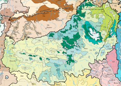
John Day/Clarno Uplands (11a)
The John Day/Clarno Uplands ecoregion forms a ring of semi-aridSemi-arid
A semi-arid climate or steppe climate describes climatic regions that receive precipitation below potential evapotranspiration, but not extremely...
foothills and low mountain
Mountain
Image:Himalaya_annotated.jpg|thumb|right|The Himalayan mountain range with Mount Everestrect 58 14 160 49 Chomo Lonzorect 200 28 335 52 Makalurect 378 24 566 45 Mount Everestrect 188 581 920 656 Tibetan Plateaurect 250 406 340 427 Rong River...
s surrounding the western perimeter of the Blue Mountains. Elevation varies from 1,200 to 5,500 feet (366 to 1,676 m). Highly dissected hills, palisades, and colorful ash beds
Volcanic ash
Volcanic ash consists of small tephra, which are bits of pulverized rock and glass created by volcanic eruptions, less than in diameter. There are three mechanisms of volcanic ash formation: gas release under decompression causing magmatic eruptions; thermal contraction from chilling on contact...
flank the valley
Valley
In geology, a valley or dale is a depression with predominant extent in one direction. A very deep river valley may be called a canyon or gorge.The terms U-shaped and V-shaped are descriptive terms of geography to characterize the form of valleys...
s of the John Day
John Day River
The John Day River is a tributary of the Columbia River, approximately long, in northeastern Oregon in the United States. Undammed along its entire length, the river is the third longest free-flowing river in the conterminous United States. There is extensive use of its waters for irrigation. Its...
and Crooked
Crooked River (Oregon)
The Crooked River is a tributary, long, of the Deschutes River in the U.S. state of Oregon. The river begins at the confluence of South Fork Crooked River and Beaver Creek. Of the two tributaries, the South Fork Crooked River is the larger and is sometimes considered part of the Crooked River proper...
rivers. Scattered butte
Butte
A butte is a conspicuous isolated hill with steep, often vertical sides and a small, relatively flat top; it is smaller than mesas, plateaus, and table landform tables. In some regions, such as the north central and northwestern United States, the word is used for any hill...
s occur. The region has a continental climate
Continental climate
Continental climate is a climate characterized by important annual variation in temperature due to the lack of significant bodies of water nearby...
moderated somewhat by marine influence
Oceanic climate
An oceanic climate, also called marine west coast climate, maritime climate, Cascadian climate and British climate for Köppen climate classification Cfb and subtropical highland for Köppen Cfb or Cwb, is a type of climate typically found along the west coasts at the middle latitudes of some of the...
. Grasslands support Bluebunch wheatgrass
Bluebunch wheatgrass
Pseudoroegneria spicata is a species of grass known by the common name Bluebunch Wheatgrass. This native western North American perennial bunchgrass is known by the scientific synonyms Elymus spicatus and Agropyron spicatum. The grass can be found from Alaska to Texas. It occurs in many types of...
, Idaho fescue, basin wildrye, Wyoming big sagebrush, and Thurber needlegrass. Higher elevations feature western juniper in transition to the ponderosa pine
Ponderosa Pine
Pinus ponderosa, commonly known as the Ponderosa Pine, Bull Pine, Blackjack Pine, or Western Yellow Pine, is a widespread and variable pine native to western North America. It was first described by David Douglas in 1826, from eastern Washington near present-day Spokane...
forest
Forest
A forest, also referred to as a wood or the woods, is an area with a high density of trees. As with cities, depending where you are in the world, what is considered a forest may vary significantly in size and have various classification according to how and what of the forest is composed...
s of the neighboring John Day/Clarno Highlands. Juniper woodlands have expanded markedly into the
sagebrush-grassland during the twentieth century due to a combination of climatic factors, fire suppression, and grazing pressure. Riparian areas support white alder
Alnus rhombifolia
Alnus rhombifolia, the White Alder, is an alder tree native to western North America, from Washington east to western Montana, southeast to the Sierra Nevada, and south through the Peninsular Ranges and Colorado Desert oases in Southern California. It occurs in riparian zone habitats at an...
, mockorange, western chokecherry, clematis
Clematis
Clematis is a genus of about 300 species within the buttercup family Ranunculaceae. Their garden hybrids have been popular among gardeners beginning with Clematis × jackmanii, a garden standby since 1862; more hybrid cultivars are being produced constantly. They are mainly of Chinese and Japanese...
, willow
Willow
Willows, sallows, and osiers form the genus Salix, around 400 species of deciduous trees and shrubs, found primarily on moist soils in cold and temperate regions of the Northern Hemisphere...
s, black cottonwood, and water birch. The largest of the Blue Mountains subregions, the John Day/Clarno Uplands covers 5022 square miles (13,007 km²) in Oregon, including all three units of the John Day Fossil Beds National Monument
John Day Fossil Beds National Monument
John Day Fossil Beds National Monument is a U.S. National Monument in Wheeler and Grant counties in east-central Oregon. Located within the John Day River basin and managed by the National Park Service, the park is known for its well-preserved layers of fossil plants and mammals that lived in the...
and portions of the Warm Springs Indian Reservation
Warm Springs Indian Reservation
The Warm Springs Indian Reservation consists of 1,019.385 sq mi in north central Oregon, in the United States, and is occupied and governed by the Confederated Tribes of Warm Springs.-Tribes:...
and the Crooked River National Grassland
Crooked River National Grassland
Crooked River National Grassland is a National Grassland located in Jefferson County in the north-central part of the U.S. state of Oregon. It has a land area of 112,357 acres . It contains two National Wild and Scenic Rivers, the Deschutes River and the Crooked River...
.
John Day/Clarno Highlands (11b)
The John Day/Clarno Highlands ecoregion is characterized by moderately to highly dissected hills and low mountains that are uniformly covered by Western ponderosa pine forest with a grass and shrub understoryUnderstory
Understory is the term for the area of a forest which grows at the lowest height level below the forest canopy. Plants in the understory consist of a mixture of seedlings and saplings of canopy trees together with understory shrubs and herbs...
. Elevation varies from 3,000 to 6,200 feet (914 to 1,990 m). The region includes broad stream
Stream
A stream is a body of water with a current, confined within a bed and stream banks. Depending on its locale or certain characteristics, a stream may be referred to as a branch, brook, beck, burn, creek, "crick", gill , kill, lick, rill, river, syke, bayou, rivulet, streamage, wash, run or...
s fed more by springs
Spring (hydrosphere)
A spring—also known as a rising or resurgence—is a component of the hydrosphere. Specifically, it is any natural situation where water flows to the surface of the earth from underground...
than by snow melt. The continental climate is tempered by a marine influence; it is not as dry, nor are temperature extremes as great, as in the Continental Zone Highlands. Historically, frequent low intensity wildfire
Wildfire
A wildfire is any uncontrolled fire in combustible vegetation that occurs in the countryside or a wilderness area. Other names such as brush fire, bushfire, forest fire, desert fire, grass fire, hill fire, squirrel fire, vegetation fire, veldfire, and wilkjjofire may be used to describe the same...
s reduced fuel loading in forests of widely spaced old-growth
Old growth forest
An old-growth forest is a forest that has attained great age , and thereby exhibits unique ecological features. An old growth forest has also usually reached a climax community...
ponderosa pine. Today, after years of fire suppression and high grade logging
Logging
Logging is the cutting, skidding, on-site processing, and loading of trees or logs onto trucks.In forestry, the term logging is sometimes used in a narrow sense concerning the logistics of moving wood from the stump to somewhere outside the forest, usually a sawmill or a lumber yard...
, land managers attempt to emulate historical fire regimes to reverse the trend toward dense thickets of young growth that carry hot, stand-replacing fires. Potential vegetation
Vegetation
Vegetation is a general term for the plant life of a region; it refers to the ground cover provided by plants. It is a general term, without specific reference to particular taxa, life forms, structure, spatial extent, or any other specific botanical or geographic characteristics. It is broader...
is mostly open ponderosa pine, with some Douglas-fir
Douglas-fir
Douglas-fir is one of the English common names for evergreen coniferous trees of the genus Pseudotsuga in the family Pinaceae. Other common names include Douglas tree, and Oregon pine. There are five species, two in western North America, one in Mexico, and two in eastern Asia...
, western juniper, mountain-mahogany
Mountain-mahogany
Cercocarpus, commonly known as mountain mahogany, is a small genus of five or six species of deciduous shrubs or small trees in the rose family , native to the western United States and northern Mexico, where they grow in chaparral and semi-desert habitats and climates, often at high altitudes...
, snowberry, mountain big sagebrush, elk sedge
Carex
Carex is a genus of plants in the family Cyperaceae, commonly known as sedges. Other members of the Cyperaceae family are also called sedges, however those of genus Carex may be called "true" sedges, and it is the most species-rich genus in the family. The study of Carex is known as...
, Idaho fescue, and bluebunch wheatgrass. Riparian areas support grand fir
Grand Fir
Abies grandis is a fir native to the Pacific Northwest and Northern California of North America, occurring at altitudes of sea level to 1,800 m...
, mountain alder, red-twig dogwood, ninebark, Wood's rose, Rocky Mountain maple, and willows. The region covers 2475 square miles (6,410 km²) in Oregon, including parts of the Ochoco
Ochoco National Forest
The Ochoco National Forest is located in Central Oregon in the United States, north and east of the City of Prineville, location of the National Forest Headquarters. It encompasses of rimrock, canyons, geologic oddities, dense pine forests, and high desert terrain, as well as the headwaters of...
, Malheur
Malheur National Forest
The Malheur National Forest is a National Forest in the U.S. state of Oregon. It contains 1.7 million acres in the Blue Mountains of eastern Oregon. The forest include high desert grasslands, sage, juniper, pine, fir, and other tree species. Elevations vary from about 4000 feet to the 9038...
, and Umatilla
Umatilla National Forest
The Umatilla National Forest, in the Blue Mountains of northeast Oregon and southeast Washington, covers an area of 1.4 million acres . In descending order of land area the forest is located in parts of Umatilla, Grant, Columbia, Morrow, Wallowa, Union, Garfield, Asotin, Wheeler, and Walla Walla...
national forest
United States National Forest
National Forest is a classification of federal lands in the United States.National Forests are largely forest and woodland areas owned by the federal government and managed by the United States Forest Service, part of the United States Department of Agriculture. Land management of these areas...
s and lower elevations in the Mill Creek
Mill Creek Wilderness
Mill Creek Wilderness is a wilderness area located in the Ochoco National Forest of central Oregon. It was established in 1984 and comprises . Of the three wilderness areas in the Ochoco National Forest - Mill Creek, Bridge Creek, and Black Canyon - Mill Creek is the largest and most heavily...
, Bridge Creek
Bridge Creek Wilderness
Bridge Creek Wilderness is a wilderness area located in the Ochoco Mountains of central Oregon, within the Ochoco National Forest. It was established in 1984 and comprises , making it one of the smallest Wilderness areas in the state.-Topography:...
, Black Canyon
Black Canyon Wilderness
The Black Canyon Wilderness of Oregon is a wilderness area in the Ochoco National Forest. It drainage basin of the South Fork of the John Day River. It lies in Grant and Wheeler counties of Oregon. The nearest city is Dayville, in Grant County. It was established in 1984 and encompasses...
and North Fork John Day
North Fork John Day Wilderness
The North Fork John Day Wilderness is a wilderness area within the Umatilla and Wallowa-Whitman National Forests, in the Blue Mountains of northeastern Oregon....
wilderness areas
National Wilderness Preservation System
The National Wilderness Preservation System of the United States protects federally managed land areas designated for preservation in their natural condition. It was established by the Wilderness Act upon the signature of President Lyndon B. Johnson on September 3, 1964...
.
Maritime-Influenced Zone (11c)
The Maritime-Influenced Zone ecoregion is the portion of the Blue Mountains ecoregion that directly intercepts marine weathersystems moving east through the Columbia River Gorge
Columbia River Gorge
The Columbia River Gorge is a canyon of the Columbia River in the Pacific Northwest of the United States. Up to deep, the canyon stretches for over as the river winds westward through the Cascade Range forming the boundary between the State of Washington to the north and Oregon to the south...
. It is characterized by a dissected, gently-sloping to hilly volcanic plateau
Volcanic plateau
A volcanic plateau is a plateau produced by volcanic activity. There are two main types: lava plateaus and pyroclastic plateaus.-Lava plateau:...
and mountain valleys. Elevation varies from 3,000 to 6,000 feet (914 to 1,829 m). Loess
Loess
Loess is an aeolian sediment formed by the accumulation of wind-blown silt, typically in the 20–50 micrometre size range, twenty percent or less clay and the balance equal parts sand and silt that are loosely cemented by calcium carbonate...
and ash soils over a substrate
Stratum
In geology and related fields, a stratum is a layer of sedimentary rock or soil with internally consistent characteristics that distinguish it from other layers...
of basalt
Basalt
Basalt is a common extrusive volcanic rock. It is usually grey to black and fine-grained due to rapid cooling of lava at the surface of a planet. It may be porphyritic containing larger crystals in a fine matrix, or vesicular, or frothy scoria. Unweathered basalt is black or grey...
retain sufficient moisture to support forest cover at lower elevations than elsewhere in the Blue Mountains. A dense and diverse shrub layer grows beneath the relatively open canopy
Canopy (forest)
In biology, the canopy is the aboveground portion of a plant community or crop, formed by plant crowns.For forests, canopy also refers to the upper layer or habitat zone, formed by mature tree crowns and including other biological organisms .Sometimes the term canopy is used to refer to the extent...
of ponderosa pine and Douglas-fir, which may delay tree regeneration after logging. Vegetation is dominated by Western ponderosa pine forests, with some Douglas-fir and grand fir. The understory and riparian shrub cover feature snowberry, spiraea
Spiraea
Spiraea , is a genus of about 80-100 species of shrubs in the family Rosaceae, subfamily Spiraeoideae. They are native to the temperate Northern Hemisphere, with the greatest diversity in eastern Asia....
, ninebark, serviceberry
Serviceberry
Amelanchier , also known as shadbush, shadwood or shadblow, serviceberry or sarvisberry, wild pear, juneberry, saskatoon, sugarplum or wild-plum, and chuckley pear is a genus of about 20 species of deciduous-leaved shrubs and small trees in the Rose family .Amelanchier is native to temperate regions...
, and red-twig dogwood. The herbaceous
Herbaceous
A herbaceous plant is a plant that has leaves and stems that die down at the end of the growing season to the soil level. They have no persistent woody stem above ground...
ground cover ground cover features heartleaf arnica, pinegrass
Calamagrostis
Calamagrostis, or Small-reed or Reedgrass, is a genus in the Grass family Poaceae with about 260 species that occur mainly in temperate regions of the Northern Hemisphere and the southern hemisphere. Towards equatorial latitudes, species of Calamagrostis generally occur at higher elevations in...
, elk sedge, Idaho fescue, Sandberg's bluegrass, and bluebunch wheatgrass. The region covers 1391 square miles (3,603 km²) in Oregon, as well as small areas across the border in Washington, and includes public land within the Umatilla National Forest
Umatilla National Forest
The Umatilla National Forest, in the Blue Mountains of northeast Oregon and southeast Washington, covers an area of 1.4 million acres . In descending order of land area the forest is located in parts of Umatilla, Grant, Columbia, Morrow, Wallowa, Union, Garfield, Asotin, Wheeler, and Walla Walla...
.
Melange (11d)
The Melange ecoregion is characterized by dissected mid-elevation mountains with the complex geologyGeology
Geology is the science comprising the study of solid Earth, the rocks of which it is composed, and the processes by which it evolves. Geology gives insight into the history of the Earth, as it provides the primary evidence for plate tectonics, the evolutionary history of life, and past climates...
typical of mélange
Mélange
In geology, a mélange is a large-scale breccia, a mappable body of rock characterized by a lack of continuous bedding and the inclusion of fragments of rock of all sizes, contained in a fine-grained deformed matrix. The mélange typically consists of a jumble of large blocks of varied lithologies...
formations. Elevation varies from 3,500 to 7,500 feet (1,067 to 2,286 m). The mountains are mostly blanketed in Tertiary
Tertiary
The Tertiary is a deprecated term for a geologic period 65 million to 2.6 million years ago. The Tertiary covered the time span between the superseded Secondary period and the Quaternary...
basalt but have a core of mixed metamorphic, metavolcanic, metasedimentary, and sedimentary rocks. Soils are drought
Drought
A drought is an extended period of months or years when a region notes a deficiency in its water supply. Generally, this occurs when a region receives consistently below average precipitation. It can have a substantial impact on the ecosystem and agriculture of the affected region...
y and high in magnesium
Magnesium
Magnesium is a chemical element with the symbol Mg, atomic number 12, and common oxidation number +2. It is an alkaline earth metal and the eighth most abundant element in the Earth's crust and ninth in the known universe as a whole...
, creating a poor medium for plant growth; reforestation
Reforestation
Reforestation is the natural or intentional restocking of existing forests and woodlands that have been depleted, usually through deforestation....
problems limit logging. Placer mining
Placer mining
Placer mining is the mining of alluvial deposits for minerals. This may be done by open-pit or by various surface excavating equipment or tunneling equipment....
for gold
Gold
Gold is a chemical element with the symbol Au and an atomic number of 79. Gold is a dense, soft, shiny, malleable and ductile metal. Pure gold has a bright yellow color and luster traditionally considered attractive, which it maintains without oxidizing in air or water. Chemically, gold is a...
altered the structure of many stream channels and left extensive tailings
Tailings
Tailings, also called mine dumps, slimes, tails, leach residue, or slickens, are the materials left over after the process of separating the valuable fraction from the uneconomic fraction of an ore...
piles in riparian areas. Lithology
Lithology
The lithology of a rock unit is a description of its physical characteristics visible at outcrop, in hand or core samples or with low magnification microscopy, such as colour, texture, grain size, or composition. It may be either a detailed description of these characteristics or be a summary of...
affects soil, vegetation, and the quantity and quality of surface water, which vary across the region. Forests are dominated by Douglas-fir, ponderosa pine, and lodgepole pine
Lodgepole Pine
Lodgepole Pine, Pinus contorta, also known as Shore Pine, is a common tree in western North America. Like all pines, it is evergreen.-Subspecies:...
, with subalpine fir
Subalpine Fir
The Subalpine Fir or Rocky Mountain Fir is a western North American fir, native to the mountains of Yukon, British Columbia and western Alberta in Canada; southeastern Alaska, Washington, Oregon, Idaho, western Montana, Wyoming, Utah, Colorado, New Mexico, Arizona, northeastern Nevada, and the...
, western larch
Western Larch
Western Larch is a species of larch native to the mountains of western North America, in Canada in southeastern British Columbia and southwestern Alberta, and in the United States in eastern Washington, eastern Oregon, northern Idaho and western Montana.It is a large deciduous coniferous tree...
, and grand fir; elsewhere, juniper steppe woodlands, shrublands, and grasslands are found. Understory plants include mountain-mahogany, snowberry, serviceberry, grouse huckleberry
Huckleberry
Huckleberry is a common name used in North America for several species of plants in two closely related genera in the family Ericaceae:* Vaccinium* GaylussaciaHuckleberry may also refer to:-Plants:...
, snowberry, prince’s pine, sidebells pyrola
Pyrola
Pyrola is a genus of evergreen herbaceous plants in the family Ericaceae. Under the old Cronquist system it was placed in its own family Pyrolaceae, but genetic research showed it belonged in the family Ericaceae. The species are commonly known as wintergreen, a name shared with several other...
, twinflower
Twinflower
Linnaea is a plant genus in the family Caprifoliaceae . The genus includes a single, generally boreal to subarctic woodland subshrub species, Linnaea borealis, commonly known as Twinflower .This plant was a favorite of Carl Linnaeus, founder of the modern system of biological nomenclature, for...
, pinegrass, elk sedge, heartleaf arnica, Idaho fescue, and bluebunch wheatgrass. Riparian areas support mountain alder, red-twig dogwood, prickly currant, black currant, Columbia monk’s hood, and bluebells
Mertensia
Mertensia is a genus of about 40 species of perennial herbaceous plants with bell-shaped blue flowers opening from pink-tinged buds. This is one of several plants commonly called bluebell.The genus is named after the German botanist Franz Carl Mertens....
. The region covers 1228 square miles (3,181 km²) in Oregon and 285 square miles (738 km²) in Idaho, including parts of the Malheur, Umatilla, and Payette
Payette National Forest
The Payette National Forest, is a U.S. National Forest located in central western Idaho, in parts of Valley, Idaho, Adams, and Washington counties. The land area consists of approximately 2.3 million acres of federally managed lands...
national forests and lower elevations in the Strawberry Mountain
Strawberry Mountain Wilderness
Strawberry Mountain Wilderness is a wilderness area of the Strawberry Mountain Range, within Malheur National Forest in the Blue Mountains of east Oregon. The area comprises , including mountain peaks and several lakes, and contains more than of hiking trails...
, Monument Rock
Monument Rock Wilderness
The Monument Rock Wilderness Area is a wilderness area within the Malheur and Wallowa-Whitman National Forests in Blue Mountains of eastern Oregon. It was designated by the United States Congress in 1984 and comprises...
, and North Fork John Day Wilderness
North Fork John Day Wilderness
The North Fork John Day Wilderness is a wilderness area within the Umatilla and Wallowa-Whitman National Forests, in the Blue Mountains of northeastern Oregon....
es.
Wallowas/Seven Devils Mountains (11e)
The Wallowas/Seven Devils Mountains ecoregion consists of deeply dissected mountains in the WallowasWallowa Mountains
The Wallowa Mountains are a mountain range located in the Columbia Plateau of northeastern Oregon in the United States. The range runs approximately 40 mi northwest to southeast in southwestern Wallowa County between the Blue Mountains to the west and the Snake River to the east. The range is...
and Seven Devil
Seven Devils Mountains
The Seven Devils are notable peaks in west central Idaho in the Hells Canyon Wilderness. They are above the east bank of the Snake River, which forms the Idaho-Oregon border. The mountains are part of the Rocky Mountains, and the tallest peaks are 7900 vertical feet above the adjacent Snake...
ranges. It occupies the mid-elevation zone between the Subalpine-Alpine Zone and the Continental Zone Foothills, at an elevation of 3,000 to 9,200 feet (914 to 2,804 m). Perennial streams following fault line
Fault line
In geology, fault line refers to the surface trace of a fault.Fault line, Fault Line, or faultline may also refer to:* "Faultline", a song from the 2008 studio album Versus by The Haunted...
s have eroded deep canyon
Canyon
A canyon or gorge is a deep ravine between cliffs often carved from the landscape by a river. Rivers have a natural tendency to reach a baseline elevation, which is the same elevation as the body of water it will eventually drain into. This forms a canyon. Most canyons were formed by a process of...
s. The character of the region's xeric forest varies between moister maritime-influenced and drier continental areas, particularly in the diversity and extent of the shrub understory. The region is dominated by Western ponderosa pine, lodgepole pine, Douglas-fir, and grand fir, with western larch, ninebark, snowberry, Rocky Mountain maple, serviceberry, mountain big sagebrush, low sagebrush
Artemisia arbuscula
Artemisia arbuscula is a species of sagebrush known by the common names little sagebrush, low sagebrush, or black sagebrush....
, big huckleberry
Huckleberry
Huckleberry is a common name used in North America for several species of plants in two closely related genera in the family Ericaceae:* Vaccinium* GaylussaciaHuckleberry may also refer to:-Plants:...
, grouse huckleberry, twinflower, prince’s pine, elk sedge, and pinegrass. Higher elevations support subalpine fir. The region covers 526 square miles (1,362 km²) in Oregon and 251 square miles (650 km²) in Idaho, containing parts of the Wallowa-Whitman
Wallowa-Whitman National Forest
The Wallowa–Whitman National Forest is a United States National Forest in Oregon. Formed by a merger of the formerly separate Wallowa and Whitman national forests, it is located in the northeastern corner of the state, in Wallowa, Baker, Union, Grant, and Umatilla counties in Oregon, and includes...
, Nez Perce
Nez Perce National Forest
The Nez Perce National Forest is located in Idaho County in central western Idaho in the northwestern United States. The forest is bounded on the east by the state of Montana, on the north by the Palouse region, and on the south and west by the Clearwater National Forest. It has a total area of...
, and Payette national forests.
Canyons and Dissected Highlands (11f)
The Canyons and Dissected Highlands ecoregion is characterized by steeply sloping, upper river canyons and dissected plateaus in the rain shadowRain shadow
A rain shadow is a dry area on the lee side of a mountainous area. The mountains block the passage of rain-producing weather systems, casting a "shadow" of dryness behind them. As shown by the diagram to the right, the warm moist air is "pulled" by the prevailing winds over a mountain...
of the mountains. It includes the southern Seven Devils Mountains and pieces of the uplifted Columbia Plateau, where the basalt has been eroded to a series of knife-edge ridge
Ridge
A ridge is a geological feature consisting of a chain of mountains or hills that form a continuous elevated crest for some distance. Ridges are usually termed hills or mountains as well, depending on size. There are several main types of ridges:...
s flanked by deep canyons. The region occupies the elevational zone above the unforested Canyons and Dissected Uplands, at an elevation of 4,000 to 6,400 feet (1,219 to 1,951 m). The steep terrain
Terrain
Terrain, or land relief, is the vertical and horizontal dimension of land surface. When relief is described underwater, the term bathymetry is used...
limits human activities. The region is drier than the marine-influenced Mesic Forest Zone that exists at similar elevations to the west. Moisture retaining loess and ash soils support Douglas-fir, larch, and grand fir on relatively level benches and Douglas-fir in unstable colluvial soils on steep canyon slopes. Western ponderosa pine forest is also present, with ninebark, snowberry, oceanspray, heartleaf arnica, elk sedge, Idaho fescue, bluebunch wheatgrass, and bluegrass. Riparian areas support mountain alder, stinking and prickly currant, thimbleberry
Thimbleberry
Rubus parviflorus, commonly called thimbleberry or salmonberry, is a species of Rubus, native to western and northern North America, from Alaska east to Ontario and Michigan, and south to northern Mexico...
, and Columbia monk’s hood. The region covers 1093 square miles (2,831 km²) in Oregon, 535 square miles (1,386 km²) in Idaho, and smaller areas in Washington, including parts of the Wallowa-Whitman
Wallowa-Whitman National Forest
The Wallowa–Whitman National Forest is a United States National Forest in Oregon. Formed by a merger of the formerly separate Wallowa and Whitman national forests, it is located in the northeastern corner of the state, in Wallowa, Baker, Union, Grant, and Umatilla counties in Oregon, and includes...
, Nez Perce
Nez Perce National Forest
The Nez Perce National Forest is located in Idaho County in central western Idaho in the northwestern United States. The forest is bounded on the east by the state of Montana, on the north by the Palouse region, and on the south and west by the Clearwater National Forest. It has a total area of...
, and Payette National Forest
Payette National Forest
The Payette National Forest, is a U.S. National Forest located in central western Idaho, in parts of Valley, Idaho, Adams, and Washington counties. The land area consists of approximately 2.3 million acres of federally managed lands...
s, the Wenaha–Tucannon Wilderness, and the Hells Canyon National Recreation Area
Hells Canyon National Recreation Area
Hells Canyon National Recreation Area is a United States National Recreation Area located on the borders of the U.S. states of Oregon and Idaho. The recreation area was established by U.S...
.
Canyons and Dissected Uplands (11g)
The Canyons and Dissected Uplands ecoregion is characterized by deep river canyons and dissected plateaus at an elevation of 1,000 to 5,000 feet (304 to 1,524 m). The SnakeSnake River
The Snake is a major river of the greater Pacific Northwest in the United States. At long, it is the largest tributary of the Columbia River, the largest North American river that empties into the Pacific Ocean...
, Grand Ronde
Grande Ronde River
The Grande Ronde River is a tributary of the Snake River, long, in northeastern Oregon and southeastern Washington in the United States. It drains an area southeast of the Blue Mountains and northwest of the Wallowa Mountains, on the Columbia Plateau...
, Imnaha
Imnaha River
The Imnaha River is a tributary of the Snake River in the U.S. state of Oregon. Flowing generally east near the headwaters and then north through Wallowa County, the entire river is designated Wild and Scenic...
, and Salmon
Salmon River (Idaho)
The Salmon River is located in Idaho in the northwestern United States. The Salmon is also known as The River of No Return. It flows for through central Idaho, draining and dropping more than between its headwaters, near Galena Summit above the Sawtooth Valley in the Sawtooth National...
river canyons have cut through the Columbia Plateau to depths of 2,000 to 5,000 feet (610 to 1,524 m). Basalt and metamorphosed rocks are typically exposed in the canyon walls; the rock assemblage differs from the basalts of the Lower Snake and Clearwater Canyons in the Columbia Plateau ecoregion
Columbia Plateau (ecoregion)
The Columbia Plateau ecoregion is a Level III ecoregion designated by the United States Environmental Protection Agency in the U.S. states of Oregon and Washington, with small areas over the Washington state border in Idaho...
. The canyons provide a refuge for elk
Elk
The Elk is the large deer, also called Cervus canadensis or wapiti, of North America and eastern Asia.Elk may also refer to:Other antlered mammals:...
, bighorn sheep
Bighorn Sheep
The bighorn sheep is a species of sheep in North America named for its large horns. These horns can weigh up to , while the sheep themselves weigh up to . Recent genetic testing indicates that there are three distinct subspecies of Ovis canadensis, one of which is endangered: Ovis canadensis sierrae...
, mountain goat
Mountain goat
The Mountain Goat , also known as the Rocky Mountain Goat, is a large-hoofed mammal found only in North America. Despite its vernacular name, it is not a member of Capra, the genus of true goats...
s, and a concentration of wintering bald eagle
Bald Eagle
The Bald Eagle is a bird of prey found in North America. It is the national bird and symbol of the United States of America. This sea eagle has two known sub-species and forms a species pair with the White-tailed Eagle...
s. Of the major historic Snake River salmon
Salmon
Salmon is the common name for several species of fish in the family Salmonidae. Several other fish in the same family are called trout; the difference is often said to be that salmon migrate and trout are resident, but this distinction does not strictly hold true...
stocks, the coho
Coho salmon
The Coho salmon, Oncorhynchus kisutch, is a species of anadromous fish in the salmon family. Coho salmon are also known as silver salmon or "silvers". It is the state animal of Chiba, Japan.-Description:...
and sockeye
Sockeye salmon
Sockeye salmon , also called red salmon or blueback salmon in the USA, is an anadromous species of salmon found in the Northern Pacific Ocean and rivers discharging into it...
are extinct, the chinook
Chinook salmon
The Chinook salmon, Oncorhynchus tshawytscha, is the largest species in the pacific salmon family. Other commonly used names for the species include King salmon, Quinnat salmon, Spring salmon and Tyee salmon...
are threatened, and summer steelhead are in decline. The depth of the canyons and the exposed metamorphic rocks result in stony soils on canyon slopes that retain little moisture. Lower north-facing slopes and upper south-facing slopes support Douglas-fir, ponderosa pine, and Idaho fescue. Lower south-facing slopes support bluebunch wheatgrass and arrowleaf balsamroot
Balsamorhiza
Balsamorhiza is a genus of plants in the sunflower family known commonly as balsamroots. These are perennials with fleshy taproots and caudices bearing erect stems and large, basal leaves. Atop the tall stems are showy yellow sunflower-like blooms. Balsamroots are native to western North America...
. Upper north-facing slopes support grand fir, ninebark, and pinegrass. Overgrazed areas are dominated by cheatgrass and exotic annuals. Riparian areas in the Snake River canyons feature hackberry and bluebunch wheatgrass. The tributary canyons feature mockorange, poison-ivy, red-twig dogwood, snowberry, and Rocky Mountain maple. The region covers 1091 square miles (2,826 km²) in Oregon, 859 square miles (2,225 km²) in Idaho, and smaller areas in Washington, including much of the Hells Canyon National Recreation Area and parts of the Wallowa-Whitman, Payette, and Nez Perce national forests.
Continental Zone Highlands (11h)
The Continental Zone Highlands ecoregion is a moderately dissected, mountainous volcanic plateau, with scattered cinder coneCinder cone
According to the , Cinder Cone is the proper name of 1 cinder cone in Canada and 7 cinder cones in the United States:In Canada: Cinder Cone In the United States:...
s, at an elevation of 4,000 to 6,700 feet (1,219 to 2,042 m). The region experiences seasonal temperature extremes and low annual precipitation
Precipitation (meteorology)
In meteorology, precipitation In meteorology, precipitation In meteorology, precipitation (also known as one of the classes of hydrometeors, which are atmospheric water phenomena is any product of the condensation of atmospheric water vapor that falls under gravity. The main forms of precipitation...
. Many of its perennial streams flow south to end in the alkaline basins of the High Desert Wetlands of the Northern Basin and Range ecoregion
Northern Basin and Range (ecoregion)
The Northern Basin and Range ecoregion is a Level III ecoregion designated by the United States Environmental Protection Agency in the U.S. states of Oregon, Idaho, Nevada, Utah, and California. It contains dissected lava plains, rolling hills, alluvial fans, valleys, and scattered mountain ranges...
. Frequent wildfires once influenced the open character of the forest. The predominant forest cover is ponderosa pine with a shrub or bunchgrass understory; the region lacks a zone of true firs found in other highland areas in the Blue Mountains. Characteristic species include ponderosa pine, Douglas-fir, grand fir, juniper, antelope bitterbrush, snowberry, mountain-mahogany, mountain big sagebrush, stiff sagebrush, elk sedge, pinegrass, bluebunch wheatgrass, and Idaho fescue. The region covers 1555 square miles (4,027 km²) in Oregon, including parts of the Ochoco
Ochoco National Forest
The Ochoco National Forest is located in Central Oregon in the United States, north and east of the City of Prineville, location of the National Forest Headquarters. It encompasses of rimrock, canyons, geologic oddities, dense pine forests, and high desert terrain, as well as the headwaters of...
and Malheur National Forest
Malheur National Forest
The Malheur National Forest is a National Forest in the U.S. state of Oregon. It contains 1.7 million acres in the Blue Mountains of eastern Oregon. The forest include high desert grasslands, sage, juniper, pine, fir, and other tree species. Elevations vary from about 4000 feet to the 9038...
s.
Continental Zone Foothills (11i)
The Continental Zone Foothills ecoregion consists of foothills, hills, and scattered buttes lying between Oregon's Blue and Wallowa mountains and the northwestern Snake River PlainSnake River Plain (ecoregion)
The Snake River Plain ecoregion is a Level III ecoregion designated by the United States Environmental Protection Agency in the U.S. states of Idaho and Oregon. It follows the Snake River across Idaho, stretching roughly from the Wyoming border to Eastern Oregon in the xeric intermontane west...
, at an elevation of 1,800 to 6,600 feet (550 to 2,010 m). The combined masses of the Cascade Range and the Blue and Wallowa mountains block any maritime influence, creating a continental climate. As a result, plants are subject to wide temperature ranges, high evapotranspiration
Evapotranspiration
Evapotranspiration is a term used to describe the sum of evaporation and plant transpiration from the Earth's land surface to atmosphere. Evaporation accounts for the movement of water to the air from sources such as the soil, canopy interception, and waterbodies...
, and high early-season moisture stress
Moisture stress
Moisture stress occurs when the water in a plant's cells is reduced to less than normal levels. This can occur because of a lack of water in the plant's root zone, higher rates of transpiration than the rate of moisture uptake by the roots, for example, because of an inability to absorb water due...
. The distribution of desert
Desert
A desert is a landscape or region that receives an extremely low amount of precipitation, less than enough to support growth of most plants. Most deserts have an average annual precipitation of less than...
shrubs varies with soil depth, texture
Soil texture
Soil texture is a qualitative classification tool used in both the field and laboratory to determine classes for agricultural soils based on their physical texture. The classes are distinguished in the field by the 'textural feel' which can be further clarified by separating the relative...
, and elevation. The sagebrush steppe
Sagebrush steppe
The sagebrush steppe is a type of shrub-steppe, which is a dry-xeric environment and plant community found in the Western United States and western Canada...
features mountain-mahogany, bitterbrush, bluebunch wheatgrass, mountain big sagebrush, Idaho fescue, Wyoming big sagebrush, Sandberg bluegrass, and, on schist
Schist
The schists constitute a group of medium-grade metamorphic rocks, chiefly notable for the preponderance of lamellar minerals such as micas, chlorite, talc, hornblende, graphite, and others. Quartz often occurs in drawn-out grains to such an extent that a particular form called quartz schist is...
, Nevada greasebush
Glossopetalon
Glossopetalon is a small genus of shrubs in the plant family Crossosomataceae. These plants are sometimes called greasebushes. They are native to the western United States and northern Mexico, where they can be found on dry mountain slopes...
. Scattered Douglas-fir
Douglas-fir
Douglas-fir is one of the English common names for evergreen coniferous trees of the genus Pseudotsuga in the family Pinaceae. Other common names include Douglas tree, and Oregon pine. There are five species, two in western North America, one in Mexico, and two in eastern Asia...
and ponderosa pine
Ponderosa Pine
Pinus ponderosa, commonly known as the Ponderosa Pine, Bull Pine, Blackjack Pine, or Western Yellow Pine, is a widespread and variable pine native to western North America. It was first described by David Douglas in 1826, from eastern Washington near present-day Spokane...
forests also occur. The region provides important wildlife habitat. Mountain-mahogany and bitterbrush provide winter cover and forage
Forage
Forage is plant material eaten by grazing livestock.Historically the term forage has meant only plants eaten by the animals directly as pasture, crop residue, or immature cereal crops, but it is also used more loosely to include similar plants cut for fodder and carried to the animals, especially...
for mule deer
Mule Deer
The mule deer is a deer indigenous to western North America. The Mule Deer gets its name from its large mule-like ears. There are believed to be several subspecies, including the black-tailed deer...
. Rodent
Rodent
Rodentia is an order of mammals also known as rodents, characterised by two continuously growing incisors in the upper and lower jaws which must be kept short by gnawing....
s, songbird
Songbird
A songbird is a bird belonging to the suborder Passeri of the perching birds . Another name that is sometimes seen as scientific or vernacular name is Oscines, from Latin oscen, "a songbird"...
s, and upland game birds also use the fruits of bitterbrush. The second largest of the Blue Mountains subregions, the Continental Zone Foothills is located in the easternmost part of the region, covering 3715 square miles (9,622 km²) in Oregon and 591 square miles (1,531 km²) in Idaho.
Blue Mountain Basins (11k)
The Blue Mountain Basins ecoregion is characterized by flat to rolling alluvial valleys containing floodplainFloodplain
A floodplain, or flood plain, is a flat or nearly flat land adjacent a stream or river that stretches from the banks of its channel to the base of the enclosing valley walls and experiences flooding during periods of high discharge...
s, fluvial terraces
Stream terrace
Fluvial terraces are elongated terraces that flank the sides of floodplains and fluvial valleys all over the world. They consist of a relatively level strip of land, called a “tread,” separated from either an adjacent floodplain, other fluvial terraces, or uplands by distinctly steeper strips of...
, and scattered buttes in the Wallowa, Grande Ronde, and Baker
Baker River (Washington)
The Baker River is an approximately , southward-flowing tributary of the Skagit River in northwestern Washington in the United States. It drains an area of the high North Cascades in the watershed of Puget Sound north of Seattle, and east of Mount Baker...
valleys. The Wallowa Valley also includes outwash
Sandur
A sandur is a glacial outwash plain formed of sediments deposited by meltwater at the terminus of a glacier.- Formation :Sandar are found in glaciated areas, such as Svalbard, Kerguelen Islands, and Iceland...
terraces, moraine
Moraine
A moraine is any glacially formed accumulation of unconsolidated glacial debris which can occur in currently glaciated and formerly glaciated regions, such as those areas acted upon by a past glacial maximum. This debris may have been plucked off a valley floor as a glacier advanced or it may have...
s, and a low elevation basalt plateau. Elevation varies from 2,600 to 5,000 feet (792 to 1,524 m). All three valleys are faultbounded graben
Graben
In geology, a graben is a depressed block of land bordered by parallel faults. Graben is German for ditch. Graben is used for both the singular and plural....
s or depressions
Depression (geology)
A depression in geology is a landform sunken or depressed below the surrounding area. Depressions may be formed by various mechanisms.Structural or tectonic related:...
filled with sediment
Sediment
Sediment is naturally occurring material that is broken down by processes of weathering and erosion, and is subsequently transported by the action of fluids such as wind, water, or ice, and/or by the force of gravity acting on the particle itself....
s. The Wallowa and Grande Ronde valleys have a marine-moderated climate and moisture-retaining loess soils. The Baker Valley, located in the rain shadow of the Elkhorn Mountains, is drier and has areas of alkaline soil. All three valleys receive stream flow from the surrounding mountains. Most of the floodplain wetland
Wetland
A wetland is an area of land whose soil is saturated with water either permanently or seasonally. Wetlands are categorised by their characteristic vegetation, which is adapted to these unique soil conditions....
s have been drained for agriculture
Agriculture
Agriculture is the cultivation of animals, plants, fungi and other life forms for food, fiber, and other products used to sustain life. Agriculture was the key implement in the rise of sedentary human civilization, whereby farming of domesticated species created food surpluses that nurtured the...
, but a remnant exists in the Grande Ronde Basin at the Ladd Marsh state wildlife area. The Baker Valley features sagebrush steppe composed of Wyoming big sagebrush, bluebunch wheatgrass, and Idaho fescue. The Wallowa and Grande Ronde valleys features grassland containing bluebunch wheatgrass and Idaho fescue. Wetlands support tufted hairgrass, sedges, basin wildrye, and black greasewood. The region covers 1984 square miles (5,139 km²) in Oregon, along the I-84
Interstate 84 in Oregon
In the U.S. state of Oregon, Interstate 84 travels east–west, following the Columbia River and the rough path of the old Oregon Trail from Portland east to Idaho. For this reason, it is also known as most of the Columbia River Highway No. 2 and all of the Old Oregon Trail Highway No. 6 . It...
corridor between La Grande
La Grande, Oregon
-Demographics:As of the census of 2000, there were 12,327 people, 5,124 households, and 2,982 families residing in the city. The population density was 2,833.5 people per square mile . There were 5,483 housing units at an average density of 1,260.3 per square mile...
and Baker City
Baker City, Oregon
Baker City is a city in and the county seat of Baker County, Oregon, United States. It was named after Edward D. Baker. The population was 9,828 at the 2010 census.-History:...
and in the Wallowa Valley near Enterprise
Enterprise, Oregon
Enterprise is a city in and the county seat of Wallowa County, Oregon, United States. The population was 1,895 at the 2000 census, with an estimated population of 1,940 in 2007.- History :...
.
Mesic Forest Zone (11l)
The disjunct Mesic Forest Zone ecoregion is characterized by a dissected, volcanic plateau and mid-elevation mountains containing the highest forested areas in the Blue Mountains, western Wallowa Mountains, and western Seven Devils Mountains. Elevation varies from 4,000 to 7,700 feet (1,219 to 2,347 m). The climate is influenced by maritime air traveling up the Columbia River Gorge, with higher precipitation than other forested regions in the Blue Mountains. Snow persists late into the spring. The ashy soil holds moisture during the dry season and supports a productive spruce-fir forest. The region's boundaries correspond to the distribution of true fir forest before the modern era of fire suppression and high grade logging. Cold slopes feature subalpine fir, Engelmann spruceEngelmann Spruce
Picea engelmannii is a species of spruce native to western North America, from central British Columbia and southwest Alberta, southwest to northern California and southeast to Arizona and New Mexico; there are also two isolated populations in northern Mexico...
, mountain hemlock
Mountain Hemlock
Tsuga mertensiana, known as Mountain Hemlock, is a species of hemlock native to the west coast of North America, with its northwestern limit on the Kenai Peninsula, Alaska, and its southeastern limit in northern Tulare County, California....
, lodgepole pine, big huckleberry, grouse huckleberry, Utah honeysuckle
Honeysuckle
Honeysuckles are arching shrubs or twining vines in the family Caprifoliaceae, native to the Northern Hemisphere. There are about 180 species of honeysuckle, 100 of which occur in China; Europe, India and North America have only about 20 native species each...
, sidebells pyrola, roundleaved violet, and northwestern sedge
Carex
Carex is a genus of plants in the family Cyperaceae, commonly known as sedges. Other members of the Cyperaceae family are also called sedges, however those of genus Carex may be called "true" sedges, and it is the most species-rich genus in the family. The study of Carex is known as...
. Cool moist slopes feature grand fir, western larch, queen’s cup beadlily, and prince’s pine. Drier slopes feature Douglas-fir, ponderosa pine, Rocky Mountain maple, ninebark, pinegrass, elk sedge, and bigleaf sandwort
Moehringia
Moehringia is a genus of flowering plants in the family Caryophyllaceae. Members of this genus and of some other genera in Caryophyllaceae are commonly called sandworts. They are found only in the north temperate zone. Moehringia was established by Linnaeus in 1753. Its type species is M....
. Lower, drier sites support ponderosa pine. The region covers 2226 square miles (5,765 km²) in Oregon, 47 square miles (122 km²) in Idaho, and small areas in Washington, including parts of the Malheur, Ochoco, Umatilla, and Wallowa-Whitman national forests, and significant portions of the Mill Creek, Bridge Creek, Black Canyon, Monument Rock, North Fork John Day, North Fork Umatilla
North Fork Umatilla Wilderness
The North Fork Umatilla Wilderness is a wilderness area located inside the Umatilla National Forest, in the Blue Mountains of northeastern Oregon...
, and Eagle Cap
Eagle Cap Wilderness
Eagle Cap Wilderness is a wilderness area located in the Wallowa Mountains of northeastern Oregon , within the Wallowa–Whitman National Forest. The Wilderness was established in 1940. In 1964, it was included in the National Wilderness Preservation System...
wildernesses.
Subalpine-Alpine Zone (11m)
The Subalpine-Alpine Zone ecoregion includes high elevation, glaciated mountains with arêteArete
Areté is the term meaning "virtue" or "excellence", from Greek ἈρετήArete may also be used:*as a given name of persons or things:**Queen Arete , a character in Homer's Odyssey.***197 Arete, an asteroid....
s, cirque
Cirque
Cirque may refer to:* Cirque, a geological formation* Makhtesh, an erosional landform found in the Negev desert of Israel and Sinai of Egypt*Cirque , an album by Biosphere* Cirque Corporation, a company that makes touchpads...
s, and tarns
Tarn (lake)
A tarn is a mountain lake or pool, formed in a cirque excavated by a glacier. A moraine may form a natural dam below a tarn. A corrie may be called a cirque.The word is derived from the Old Norse word tjörn meaning pond...
. High gradient streams have boulder
Boulder
In geology, a boulder is a rock with grain size of usually no less than 256 mm diameter. While a boulder may be small enough to move or roll manually, others are extremely massive....
and cobble
Cobblestone
Cobblestones are stones that were frequently used in the pavement of early streets. "Cobblestone" is derived from the very old English word "cob", which had a wide range of meanings, one of which was "rounded lump" with overtones of large size...
substrates. Elevation varies from 6,500 to 9,900 feet (1,981 to 3,018 m). The region begins where the forest cover becomes broken by alpine meadows and continues through alpine meadowland to include the exposed rock, permanent snowfields, and glacial ice of the highest mountain peaks. Very open forests of subalpine fir, Engelmann spruce, and whitebark pine
Whitebark Pine
Pinus albicaulis, known commonly as Whitebark Pine, Pitch Pine, Scrub Pine, and Creeping Pine occurs in the mountains of the Western United States and Canada, specifically the subalpine areas of the Sierra Nevada, the Cascade Range, the Pacific Coast Ranges, and the northern Rocky Mountains –...
tolerate the cold soils, deep snowpack, and extremely short growing season near timberline. Dry south-facing slopes support mountain big sagebrush and Idaho fescue. At the treeline, krummholz
Krummholz
Krummholz or Krumholtz formation — also called Knieholz — is a particular feature of subarctic and subalpine tree line landscapes. Continual exposure to fierce, freezing winds causes vegetation to become stunted and deformed...
is found. Wet meadows support heather
Cassiope
Cassiope is a genus of 9-12 small shrubby species in the family Ericaceae. They are native to the Arctic and north temperate montane regions. Common names, shared with several other similar related genera, include heather and heath....
and Parry’s rush
Juncus
Juncus is a genus in the plant family Juncaceae. It consists of some 200 to 300 or more species of grassy plants commonly called rushes...
. Historically, green fescue and sedges covered high alpine meadows and ridges, particularly in the Wallowas; but, following intense sheep grazing in the early twentieth century, many alpine plant associations reverted to seral or exotic species on rocky subsoil
Subsoil
Subsoil, or substrata, is the layer of soil under the topsoil on the surface of the ground. The subsoil may include substances such as clay and/or sand that has only been partially broken down by air, sunlight, water, wind etc., to produce true soil...
. The region covers 540 square miles (1,399 km²) Oregon, in the heart of the Eagle Cap
Eagle Cap Wilderness
Eagle Cap Wilderness is a wilderness area located in the Wallowa Mountains of northeastern Oregon , within the Wallowa–Whitman National Forest. The Wilderness was established in 1940. In 1964, it was included in the National Wilderness Preservation System...
and Strawberry Mountain Wilderness
Strawberry Mountain Wilderness
Strawberry Mountain Wilderness is a wilderness area of the Strawberry Mountain Range, within Malheur National Forest in the Blue Mountains of east Oregon. The area comprises , including mountain peaks and several lakes, and contains more than of hiking trails...
es, and 71 square miles (184 km²) in Idaho, in the Payette National Forest
Payette National Forest
The Payette National Forest, is a U.S. National Forest located in central western Idaho, in parts of Valley, Idaho, Adams, and Washington counties. The land area consists of approximately 2.3 million acres of federally managed lands...
.
Deschutes River Valley (11n)
The Deschutes River Valley ecoregion, named for the Deschutes River, which it partially contains, is a broad valley with deeply incised streams. The southern part is capped by basalt and nearly level. In the northern part, the basalt cap is absent, and the terrain is more rolling and dissected. Elevation varies from 2,000 to 4,000 feet (610 to 1,219 m), with buttes as high as 5300 feet (1,615 m). The climate has a marine influence, and the region is less arid than the botanically similar High Lava Plains of the Northern Basin and Range ecoregion to the southeast. Because of the proximity of the High CascadesCascades (ecoregion)
The Cascades ecoregion is a Level III ecoregion designated by the United States Environmental Protection Agency in the U.S. states of Washington, Oregon, and California...
, stream density and water availability are high. As a result, human population density
Population density
Population density is a measurement of population per unit area or unit volume. It is frequently applied to living organisms, and particularly to humans...
is much higher than in the High Lava Plains. Canals carry river water to irrigated farms on floodplains and terraces growing grass seed, winter wheat
Winter wheat
Winter wheat is a type of wheat that is planted from September to December in the Northern Hemisphere. Winter wheat sprouts before freezing occurs, then becomes dormant until the soil warms in the spring. Winter wheat needs a few weeks of cold before being able to flower, however persistent snow...
, potatoes, alfalfa
Alfalfa
Alfalfa is a flowering plant in the pea family Fabaceae cultivated as an important forage crop in the US, Canada, Argentina, France, Australia, the Middle East, South Africa, and many other countries. It is known as lucerne in the UK, France, Australia, South Africa and New Zealand, and known as...
, mint
Mentha
Mentha is a genus of flowering plants in the family Lamiaceae . The species are not clearly distinct and estimates of the number of species varies from 13 to 18. Hybridization between some of the species occurs naturally...
, onion
Onion
The onion , also known as the bulb onion, common onion and garden onion, is the most widely cultivated species of the genus Allium. The genus Allium also contains a number of other species variously referred to as onions and cultivated for food, such as the Japanese bunching onion The onion...
s, carrot
Carrot
The carrot is a root vegetable, usually orange in colour, though purple, red, white, and yellow varieties exist. It has a crisp texture when fresh...
s for seed, and garlic
Garlic
Allium sativum, commonly known as garlic, is a species in the onion genus, Allium. Its close relatives include the onion, shallot, leek, chive, and rakkyo. Dating back over 6,000 years, garlic is native to central Asia, and has long been a staple in the Mediterranean region, as well as a frequent...
. Potential natural vegetation includes Wyoming big sagebrush, antelope bitterbrush, basin big sagebrush, mountain big sagebrush, bluebunch wheatgrass, Idaho fescue, and needle-and-thread on the sagebrush steppe, with western juniper on shallow, rocky soils. Riparian areas support white alder, black hawthorn, ponderosa pine, and juniper. Himalayan blackberry, reed canary grass
Reed canary grass
Reed canarygrass, Phalaris arundinacea, is a tall, perennial bunchgrass that commonly forms extensive single-species stands along the margins of lakes and streams and in wet open areas, with a wide distribution in Europe, Asia, northern Africa and North America.-Description:The stems can reach 2.5...
, and sweet clover are introduced species. The region covers 1576 square miles (4,082 km²) along the Deschutes and Crooked rivers in Oregon, in a triangle defined roughly by Warm Springs
Warm Springs, Oregon
Warm Springs is a census-designated place and an unincorporated community in Jefferson County, Oregon, United States. Located on the Warm Springs Indian Reservation, the community is also known as the "Warm Springs Agency." The population was 2,431 at the 2000 census.-Geography:Warm Springs is...
, Prineville
Prineville, Oregon
Prineville is a city in and the county seat of Crook County, Oregon, United States. It was named for the first merchant located in the present location, Barney Prine. The population was 9,253 at the 2010 census.- History :...
, and Bend
Bend, Oregon
Bend is a city in and the county seat of Deschutes County, Oregon, United States, and the principal city of the Bend, Oregon Metropolitan Statistical Area. Bend is Central Oregon's largest city, and, despite its modest size, is the de facto metropolis of the region, owing to the low population...
. It includes parts of the Warm Springs Indian Reservation
Warm Springs Indian Reservation
The Warm Springs Indian Reservation consists of 1,019.385 sq mi in north central Oregon, in the United States, and is occupied and governed by the Confederated Tribes of Warm Springs.-Tribes:...
and the Crooked River National Grassland
Crooked River National Grassland
Crooked River National Grassland is a National Grassland located in Jefferson County in the north-central part of the U.S. state of Oregon. It has a land area of 112,357 acres . It contains two National Wild and Scenic Rivers, the Deschutes River and the Crooked River...
.
Cold Basins (11o)
The Cold Basins ecoregion contains cold, wet valleys and basins and wet meadowWet meadow
A wet meadow is a semi-wetland meadow which is saturated with water throughout much of the year. Wet meadows may occur because of poor drainage or the receipt of large amounts of water from rain or melted snow. They may also occur in riparian zones....
s at an elevation of 3,600 to 6,000 feet (1,097 to 1,829 m). The high meadows are often alluvial and have a high water table
Water table
The water table is the level at which the submarine pressure is far from atmospheric pressure. It may be conveniently visualized as the 'surface' of the subsurface materials that are saturated with groundwater in a given vicinity. However, saturated conditions may extend above the water table as...
and silt
Silt
Silt is granular material of a size somewhere between sand and clay whose mineral origin is quartz and feldspar. Silt may occur as a soil or as suspended sediment in a surface water body...
or clay
Clay
Clay is a general term including many combinations of one or more clay minerals with traces of metal oxides and organic matter. Geologic clay deposits are mostly composed of phyllosilicate minerals containing variable amounts of water trapped in the mineral structure.- Formation :Clay minerals...
soils. Streams, if not channelized, are meandering and have a dynamic interaction with their flood plains. These unconstrained streams provide pool habitats that are important to salmonids. The short growing season
Growing season
In botany, horticulture, and agriculture the growing season is the period of each year when native plants and ornamental plants grow; and when crops can be grown....
and saturated soil make these basins unsuitable for most crops, except hay, but they are heavily grazed by cattle and elk. Potential natural vegetation includes sedges, mountain big sagebrush, low sagebrush, and Idaho fescue on the sagebrush steppe and tufted hairgrass, Baltic rush, and alien Kentucky bluegrass in the wetlands and wet meadows. The smallest of the Blue Mountains subregions, the Cold Basins covers 400 square miles (1,036 km²) in several disjunct areas in central and eastern Oregon.
See also
- Ecoregions defined by the EPA and the Commission for Environmental CooperationCommission for Environmental CooperationThe Commission for Environmental Cooperation was established by Canada, Mexico, and the United States to implement the North American Agreement on Environmental Cooperation , the environmental side accord to the North American Free Trade Agreement...
:- List of ecoregions in North America (CEC)
- List of ecoregions in the United States (EPA)
- List of ecoregions in Oregon
- List of ecoregions in Idaho
- List of ecoregions in Washington
- The conservation group World Wildlife Fund maintains an alternate classification system:
- List of ecoregions (WWF)
- List of ecoregions in the United States (WWF)