
Water table
Encyclopedia
Atmospheric pressure
Atmospheric pressure is the force per unit area exerted into a surface by the weight of air above that surface in the atmosphere of Earth . In most circumstances atmospheric pressure is closely approximated by the hydrostatic pressure caused by the weight of air above the measurement point...
. It may be conveniently visualized as the 'surface' of the subsurface materials that are saturated with groundwater
Groundwater
Groundwater is water located beneath the ground surface in soil pore spaces and in the fractures of rock formations. A unit of rock or an unconsolidated deposit is called an aquifer when it can yield a usable quantity of water. The depth at which soil pore spaces or fractures and voids in rock...
in a given vicinity. However, saturated conditions may extend above the water table as surface tension holds water in some pores below atmospheric pressure. Individual points on the water table are typically measured as the elevation that the water rises to in a well screened in the shallow groundwater.
The groundwater may be from infiltrating precipitation or from groundwater flowing into the aquifer. In areas with sufficient precipitation, water infiltrates through pore spaces in the soil, passing through the unsaturated zone. At increasing depths water fills in more of the pore spaces in the soils, until the zone of saturation is reached. In permeable or porous materials, such as sands and well fractured bedrock, the water table forms a relatively horizontal plane. Below the water table, in the phreatic zone
Phreatic zone
The phreatic zone, or zone of saturation, is the area in an aquifer, below the water table, in which relatively all pores and fractures are saturated with water. The phreatic zone may fluctuate with changes of season and during wet and dry periods....
, permeable units that yield groundwater are called aquifer
Aquifer
An aquifer is a wet underground layer of water-bearing permeable rock or unconsolidated materials from which groundwater can be usefully extracted using a water well. The study of water flow in aquifers and the characterization of aquifers is called hydrogeology...
s. The ability of the aquifer
Aquifer
An aquifer is a wet underground layer of water-bearing permeable rock or unconsolidated materials from which groundwater can be usefully extracted using a water well. The study of water flow in aquifers and the characterization of aquifers is called hydrogeology...
to store groundwater
Groundwater
Groundwater is water located beneath the ground surface in soil pore spaces and in the fractures of rock formations. A unit of rock or an unconsolidated deposit is called an aquifer when it can yield a usable quantity of water. The depth at which soil pore spaces or fractures and voids in rock...
is dependent on the primary and secondary porosity
Porosity
Porosity or void fraction is a measure of the void spaces in a material, and is a fraction of the volume of voids over the total volume, between 0–1, or as a percentage between 0–100%...
and permeability
Permeability (fluid)
Permeability in fluid mechanics and the earth sciences is a measure of the ability of a porous material to allow fluids to pass through it.- Units :...
of the rock or soil. In soil that are less permeable, such as tight bedrock formations and historic lakebed deposits, the water table may be more difficult to define.
The water table should not be confused with the water level in a deeper well. If a deeper aquifer
Aquifer
An aquifer is a wet underground layer of water-bearing permeable rock or unconsolidated materials from which groundwater can be usefully extracted using a water well. The study of water flow in aquifers and the characterization of aquifers is called hydrogeology...
has a lower permeable unit that confines the upward flow, then the water level in a well screened in this aquifer may rise to a level that is greater or less than the elevation of the actual water table. The elevation of the water in this deeper well is dependent upon the pressure in the deeper aquifer and is referred to as the potentiometric surface
Potentiometric surface
A potentiometric surface is based on hydraulic principles. For example, we know that two connected storage tanks with one full and one empty will gradually fill/drain to the same level. This is because of atmospheric pressure and gravity. A potentiometric surface is the imaginary line where a given...
, not the water table.
Form
The water table may vary due to seasonal changes in precipitationPrecipitation (meteorology)
In meteorology, precipitation In meteorology, precipitation In meteorology, precipitation (also known as one of the classes of hydrometeors, which are atmospheric water phenomena is any product of the condensation of atmospheric water vapor that falls under gravity. The main forms of precipitation...
, evapotranspiration
Evapotranspiration
Evapotranspiration is a term used to describe the sum of evaporation and plant transpiration from the Earth's land surface to atmosphere. Evaporation accounts for the movement of water to the air from sources such as the soil, canopy interception, and waterbodies...
, topography
Topography
Topography is the study of Earth's surface shape and features or those ofplanets, moons, and asteroids...
and structural geology
Structural geology
Structural geology is the study of the three-dimensional distribution of rock units with respect to their deformational histories. The primary goal of structural geology is to use measurements of present-day rock geometries to uncover information about the history of deformation in the rocks, and...
. In undeveloped regions with permeable soils that receive sufficient amounts of precipitation
Precipitation (meteorology)
In meteorology, precipitation In meteorology, precipitation In meteorology, precipitation (also known as one of the classes of hydrometeors, which are atmospheric water phenomena is any product of the condensation of atmospheric water vapor that falls under gravity. The main forms of precipitation...
, the water table typically slopes toward rivers that act to drain the groundwater away and release the pressure in the aquifer. Springs, rivers, lakes and oases
Oasis
In geography, an oasis or cienega is an isolated area of vegetation in a desert, typically surrounding a spring or similar water source...
occur when the water table reaches the surface. Springs commonly form on hillsides, where the Earth's slanting surface may "intersect" with the water table. Groundwater entering rivers and lakes accounts for the base-flow water levels in water bodies.
Surface topography
Within an aquifer, the water table is rarely horizontal, but reflects the surface relief due to the capillary effect in soilSoil
Soil is a natural body consisting of layers of mineral constituents of variable thicknesses, which differ from the parent materials in their morphological, physical, chemical, and mineralogical characteristics...
s, sediment
Sediment
Sediment is naturally occurring material that is broken down by processes of weathering and erosion, and is subsequently transported by the action of fluids such as wind, water, or ice, and/or by the force of gravity acting on the particle itself....
s and other porous media. In the aquifer, groundwater flows from points of higher pressure to points of lower pressure, and the direction of groundwater flow typically has both a horizontal and a vertical component. The slope of the water table is known as the hydraulic gradient, which depends on the rate at which water is added to and removed from the aquifer and the permeability of the material. The water table does not always mimic the topography due to variations in the underlying geological structure (e.g. folded, faulted, fractured bedrock).
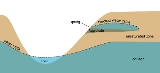
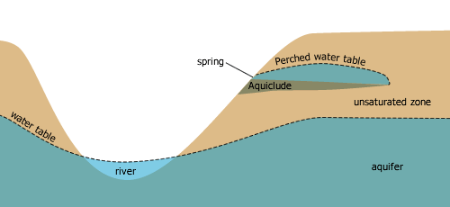
Perched water tables
A perched water table (or perched aquifer) is an aquifer that occurs above the regional water table, in the vadose zoneVadose zone
The vadose zone, also termed the unsaturated zone, is the portion of Earth between the land surface and the top of the phreatic zone i.e. the position at which the groundwater is at atmospheric pressure . Hence the vadose zone extends from the top of the ground surface to the water table...
. This occurs when there is an impermeable layer of rock or sediment (aquiclude) or relatively impermeable layer (aquitard) above the main water table/aquifer but below the surface of the land. If a perched aquifer's flow intersects the Earth's dry surface, at a valley wall for example, the water is discharged as a spring
Spring (hydrosphere)
A spring—also known as a rising or resurgence—is a component of the hydrosphere. Specifically, it is any natural situation where water flows to the surface of the earth from underground...
.
Fluctuations
Tidal fluctuations
On low-lying oceanic islands with porous soil, fresh water tends to collect in lenticular pools on top of the denser seawater intruding from the sides of the islands. Such an island's freshwater lens, and thus the water table, rises and falls with the tides.Seasonal fluctuations
In some regions, for example, Great BritainGreat Britain
Great Britain or Britain is an island situated to the northwest of Continental Europe. It is the ninth largest island in the world, and the largest European island, as well as the largest of the British Isles...
or California
California
California is a state located on the West Coast of the United States. It is by far the most populous U.S. state, and the third-largest by land area...
, winter precipitation
Precipitation (meteorology)
In meteorology, precipitation In meteorology, precipitation In meteorology, precipitation (also known as one of the classes of hydrometeors, which are atmospheric water phenomena is any product of the condensation of atmospheric water vapor that falls under gravity. The main forms of precipitation...
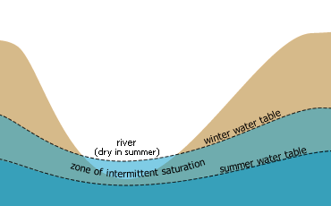
is often higher than summer precipitation and so the groundwater storage is not fully recharged in summer. Consequently, the water table is lower in the summer period yearly. This disparity between the level of the winter and summer water table is known as the zone of intermittent saturation, wherein the water table will fluctuate in response to climatic conditions.
Long term fluctuations
Fossil waterFossil water
Fossil water or paleowater is groundwater that has remained sealed in an aquifer for a long period of time. Water can rest underground in "fossil aquifers" for thousands or even millions of years...
is groundwater that has remained in an aquifer for millennia, and occurs mainly in desert
Desert
A desert is a landscape or region that receives an extremely low amount of precipitation, less than enough to support growth of most plants. Most deserts have an average annual precipitation of less than...
s. Fossil water is non-renewable by present day rainfall due to its depth below the surface, and any extraction causes a permanent change in the water table in such regions.
Effects on Climate
Aquifer drawdownDrawdown
Drawdown has four distinct meanings:* Drawdown , a lowering of a reservoir or a change in hydraulic head in an aquifer, typically due to pumping a well.* Drawdown , decline in the value of an investment, below its all-time high....
or overdrafting
Overdrafting
Overdrafting is the process of extracting groundwater beyond the safe yield or equilibrium yield of the aquifer.Since every groundwater basin recharges at a different rate depending upon precipitation, vegetative cover and soil conservation practises, the quantity of groundwater that can be safely...
and the pumping of fossil water
Fossil water
Fossil water or paleowater is groundwater that has remained sealed in an aquifer for a long period of time. Water can rest underground in "fossil aquifers" for thousands or even millions of years...
increases the total amount of water in the hydrosphere
Hydrosphere
A hydrosphere in physical geography describes the combined mass of water found on, under, and over the surface of a planet....
that is subject to transpiration
Transpiration
Transpiration is a process similar to evaporation. It is a part of the water cycle, and it is the loss of water vapor from parts of plants , especially in leaves but also in stems, flowers and roots. Leaf surfaces are dotted with openings which are collectively called stomata, and in most plants...
and evaporation
Evaporation
Evaporation is a type of vaporization of a liquid that occurs only on the surface of a liquid. The other type of vaporization is boiling, which, instead, occurs on the entire mass of the liquid....
thereby causing accretion
Accretion (atmosphere)
Accretion is an atmospheric science term for when an ice crystal or snowflake hits a supercooled liquid droplet, which then freeze together. This increases the size of the water particle. A common example of this that is visible to people is graupel....
in water vapour and cloud cover
Cloud cover
Cloud cover refers to the fraction of the sky obscured by clouds when observed from a particular location...
which are the primary absorbers of infrared
Infrared
Infrared light is electromagnetic radiation with a wavelength longer than that of visible light, measured from the nominal edge of visible red light at 0.74 micrometres , and extending conventionally to 300 µm...
radiation in the earth's atmosphere
Atmosphere
An atmosphere is a layer of gases that may surround a material body of sufficient mass, and that is held in place by the gravity of the body. An atmosphere may be retained for a longer duration, if the gravity is high and the atmosphere's temperature is low...
. Adding water to the system has a forcing effect
Global warming
Global warming refers to the rising average temperature of Earth's atmosphere and oceans and its projected continuation. In the last 100 years, Earth's average surface temperature increased by about with about two thirds of the increase occurring over just the last three decades...
on the whole earth system
Gaia hypothesis
The Gaia hypothesis, also known as Gaia theory or Gaia principle, proposes that all organisms and their inorganic surroundings on Earth are closely integrated to form a single and self-regulating complex system, maintaining the conditions for life on the planet.The scientific investigation of the...
, an accurate estimate of which hydrogeological fact is yet to be quantified.
See also
- GroundwaterGroundwaterGroundwater is water located beneath the ground surface in soil pore spaces and in the fractures of rock formations. A unit of rock or an unconsolidated deposit is called an aquifer when it can yield a usable quantity of water. The depth at which soil pore spaces or fractures and voids in rock...
- Groundwater recharge
- AquiferAquiferAn aquifer is a wet underground layer of water-bearing permeable rock or unconsolidated materials from which groundwater can be usefully extracted using a water well. The study of water flow in aquifers and the characterization of aquifers is called hydrogeology...
- HydrogeologyHydrogeologyHydrogeology is the area of geology that deals with the distribution and movement of groundwater in the soil and rocks of the Earth's crust, . The term geohydrology is often used interchangeably...
- Watertable controlWatertable controlWatertable control is the practice of controlling the water table in agricultural land by subsurface drainage with proper criteria to improve the crop production.- Description and definitions :...
- Origin of water on EarthOrigin of water on EarthThe question of the origin of water on Earth, or the question of why there is clearly more water on the Earth than on the other planets of the Solar System, has not been clarified...
- SalinitySalinitySalinity is the saltiness or dissolved salt content of a body of water. It is a general term used to describe the levels of different salts such as sodium chloride, magnesium and calcium sulfates, and bicarbonates...
- Salinity in AustraliaSalinity in AustraliaSoil salinity and dryland salinity are two problems degrading the environment of Australia. Salinity is a concern in most states, but especially in the south-west of Western Australia....