

Canyon
Encyclopedia

Ravine
A ravine is a landform narrower than a canyon and is often the product of streamcutting erosion. Ravines are typically classified as larger in scale than gullies, although smaller than valleys. A ravine is generally a fluvial slope landform of relatively steep sides, on the order of twenty to...
between cliff
Cliff
In geography and geology, a cliff is a significant vertical, or near vertical, rock exposure. Cliffs are formed as erosion landforms due to the processes of erosion and weathering that produce them. Cliffs are common on coasts, in mountainous areas, escarpments and along rivers. Cliffs are usually...
s often carved from the landscape by a river. Rivers have a natural tendency to reach a baseline elevation, which is the same elevation as the body of water it will eventually drain into. This forms a canyon. Most canyons were formed by a process of long-time erosion
Erosion
Erosion is when materials are removed from the surface and changed into something else. It only works by hydraulic actions and transport of solids in the natural environment, and leads to the deposition of these materials elsewhere...
from a plateau
Plateau
In geology and earth science, a plateau , also called a high plain or tableland, is an area of highland, usually consisting of relatively flat terrain. A highly eroded plateau is called a dissected plateau...
level. The cliff
Cliff
In geography and geology, a cliff is a significant vertical, or near vertical, rock exposure. Cliffs are formed as erosion landforms due to the processes of erosion and weathering that produce them. Cliffs are common on coasts, in mountainous areas, escarpments and along rivers. Cliffs are usually...
s form because harder rock strata that are resistant to erosion and weathering remain exposed on the valley walls. Canyons are much more common in arid areas than in wet areas because physical weathering has a greater effect in arid zones. The wind and water from the river combine to erode and cut away less resistant materials such as shales. The freezing and expansion of water also serves to help form canyons. Water seeps into cracks between the rocks and freezes, pushing the rocks apart and eventually causing large chunks to break off the canyon walls which are also known as frost wedging. Canyon walls are often formed of resistant sandstone
Sandstone
Sandstone is a sedimentary rock composed mainly of sand-sized minerals or rock grains.Most sandstone is composed of quartz and/or feldspar because these are the most common minerals in the Earth's crust. Like sand, sandstone may be any colour, but the most common colours are tan, brown, yellow,...
s or granite
Granite
Granite is a common and widely occurring type of intrusive, felsic, igneous rock. Granite usually has a medium- to coarse-grained texture. Occasionally some individual crystals are larger than the groundmass, in which case the texture is known as porphyritic. A granitic rock with a porphyritic...
. Submarine canyon
Submarine canyon
A submarine canyon is a steep-sided valley on the sea floor of the continental slope. Many submarine canyons are found as extensions to large rivers; however there are some that have no such association. Canyons cutting the continental slopes have been found at depths greater than 2 km below sea...
s form underwater, generally at the mouths of rivers. The word canyon is Spanish in origin (cañón, kaˈɲon). The word canyon is generally used in the United States
United States
The United States of America is a federal constitutional republic comprising fifty states and a federal district...
, while the word gorge is more common in Europe and Oceania
Oceania
Oceania is a region centered on the islands of the tropical Pacific Ocean. Conceptions of what constitutes Oceania range from the coral atolls and volcanic islands of the South Pacific to the entire insular region between Asia and the Americas, including Australasia and the Malay Archipelago...
, though it is also used in some parts of the United States and Canada. The military derived word defile
Defile (geography)
Defile is a geographic term for a narrow pass or gorge between mountains or hills. It has its origins as a military description of a pass through which troops can march only in a narrow column or with a narrow front...
is occasionally used in the United Kingdom
United Kingdom
The United Kingdom of Great Britain and Northern IrelandIn the United Kingdom and Dependencies, other languages have been officially recognised as legitimate autochthonous languages under the European Charter for Regional or Minority Languages...
.
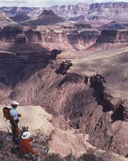
A famous example is the Grand Canyon
Grand Canyon
The Grand Canyon is a steep-sided canyon carved by the Colorado River in the United States in the state of Arizona. It is largely contained within the Grand Canyon National Park, the 15th national park in the United States...
in
Arizona
Arizona
Arizona ; is a state located in the southwestern region of the United States. It is also part of the western United States and the mountain west. The capital and largest city is Phoenix...
with an average depth of one mile and a volume of 4.17 trillion cubic metres. In the southwestern United States, canyons are important archeologically because of the many cliff-dwelling
Cliff-dwelling
Cliff dwelling is the general archaeological term for the habitations of prehistorical peoples, formed by using niches or caves in high cliffs, with more or less excavation or with additions in the way of masonry....
s built there, largely by the earlier inhabitants, Ancient Pueblo Peoples
Ancient Pueblo Peoples
Ancient Pueblo People or Ancestral Pueblo peoples were an ancient Native American culture centered on the present-day Four Corners area of the United States, comprising southern Utah, northern Arizona, northwest New Mexico, and southern Colorado...
.
The Yarlung Zangbo Grand Canyon (or Tsangpo Canyon), along the Yarlung Tsangpo River in Tibet
Tibet Autonomous Region
The Tibet Autonomous Region , Tibet or Xizang for short, also called the Xizang Autonomous Region is a province-level autonomous region of the People's Republic of China , created in 1965....
, China
People's Republic of China
China , officially the People's Republic of China , is the most populous country in the world, with over 1.3 billion citizens. Located in East Asia, the country covers approximately 9.6 million square kilometres...
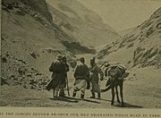
, is regarded by some as the deepest canyon in the world at 18,000 feet, and is slightly longer than Grand Canyon making it one of the world's largest. The Kali Gandaki Gorge
Kali Gandaki Gorge
The Kali Gandaki Gorge or Andha Galchi is the gorge of the Kali Gandaki in the Himalayas in Nepal, by some measures the deepest gorge in the world....
in midwest Nepal is seen by others to be the deepest canyon, with a 21,000 foot difference between the level of the river and the peaks surrounding it.
Sometimes large rivers run through canyons as the result of gradual geological uplift. These are called entrenched river
Entrenched river
An entrenched river is a river that is confined to a canyon or gorge, usually with a relatively narrow width and little or no flood plain, and often with meanders worn into the landscape...
s, because they are unable to easily alter their course. The Colorado River in the Southwest
Southwestern United States
The Southwestern United States is a region defined in different ways by different sources. Broad definitions include nearly a quarter of the United States, including Arizona, California, Colorado, Nevada, New Mexico, Oklahoma, Texas and Utah...
and the Snake River
Snake River
The Snake is a major river of the greater Pacific Northwest in the United States. At long, it is the largest tributary of the Columbia River, the largest North American river that empties into the Pacific Ocean...
in the Northwest
Northwestern United States
The Northwestern United States comprise the northwestern states up to the western Great Plains regions of the United States, and consistently include the states of Oregon, Washington, Idaho, Montana, Wyoming, to which part of southeast Alaska is also sometimes included...
are two examples of tectonic uplift
Tectonic uplift
Tectonic uplift is a geological process most often caused by plate tectonics which increases elevation. The opposite of uplift is subsidence, which results in a decrease in elevation. Uplift may be orogenic or isostatic.-Orogenic uplift:...
.
Canyons often form in areas of limestone
Limestone
Limestone is a sedimentary rock composed largely of the minerals calcite and aragonite, which are different crystal forms of calcium carbonate . Many limestones are composed from skeletal fragments of marine organisms such as coral or foraminifera....
rock. Limestone is to a certain extent soluble, so cave
Cave
A cave or cavern is a natural underground space large enough for a human to enter. The term applies to natural cavities some part of which is in total darkness. The word cave also includes smaller spaces like rock shelters, sea caves, and grottos.Speleology is the science of exploration and study...
systems form in the rock. When these collapse a canyon is left, for example in the Mendip Hills
Mendip Hills
The Mendip Hills is a range of limestone hills to the south of Bristol and Bath in Somerset, England. Running east to west between Weston-super-Mare and Frome, the hills overlook the Somerset Levels to the south and the Avon Valley to the north...
in Somerset
Somerset
The ceremonial and non-metropolitan county of Somerset in South West England borders Bristol and Gloucestershire to the north, Wiltshire to the east, Dorset to the south-east, and Devon to the south-west. It is partly bounded to the north and west by the Bristol Channel and the estuary of the...
and Yorkshire Dales
Yorkshire Dales
The Yorkshire Dales is the name given to an upland area in Northern England.The area lies within the historic county boundaries of Yorkshire, though it spans the ceremonial counties of North Yorkshire, West Yorkshire and Cumbria...
in Yorkshire
Yorkshire
Yorkshire is a historic county of northern England and the largest in the United Kingdom. Because of its great size in comparison to other English counties, functions have been increasingly undertaken over time by its subdivisions, which have also been subject to periodic reform...
, England.
A canyon may also refer to a rift between two mountain peaks such as those in ranges such as the Rocky Mountains
Rocky Mountains
The Rocky Mountains are a major mountain range in western North America. The Rocky Mountains stretch more than from the northernmost part of British Columbia, in western Canada, to New Mexico, in the southwestern United States...
, the Alps
Alps
The Alps is one of the great mountain range systems of Europe, stretching from Austria and Slovenia in the east through Italy, Switzerland, Liechtenstein and Germany to France in the west....
, the Himalayas
Himalayas
The Himalaya Range or Himalaya Mountains Sanskrit: Devanagari: हिमालय, literally "abode of snow"), usually called the Himalayas or Himalaya for short, is a mountain range in Asia, separating the Indian subcontinent from the Tibetan Plateau...
or the Andes
Andes
The Andes is the world's longest continental mountain range. It is a continual range of highlands along the western coast of South America. This range is about long, about to wide , and of an average height of about .Along its length, the Andes is split into several ranges, which are separated...
. Usually a river or stream and erosion carve out such splits between mountains. Examples of mountain type canyons are Provo Canyon
Provo Canyon
Provo Canyon is a canyon located in unincorporated Utah County, Utah, USA and Wasatch County, Utah. Provo Canyon splits between Mount Timpanogos on the north and Mount Cascade on the south. The canyon extends from Orem on the west end to Heber City on the east. The canyon's main thoroughfare is...
in Utah or Yosemite National Park
Yosemite National Park
Yosemite National Park is a United States National Park spanning eastern portions of Tuolumne, Mariposa and Madera counties in east central California, United States. The park covers an area of and reaches across the western slopes of the Sierra Nevada mountain chain...
in California's Sierra Nevada. Canyons within mountains or gorges that only have an opening on one side are called box canyon
Box canyon
Box Canyon is a Box canyon in Ouray County, Colorado, United States. It was originally founded as a mining camp and helped the city of Ouray establish itself as a permanent community. Box Canyon is home to Box Canyon Falls, a 285-foot waterfall, with quartzite walls that extend almost one hundred...
s. Slot canyon
Slot canyon
A slot canyon is a narrow canyon, formed by the wear of water rushing through rock. A slot canyon is significantly deeper than it is wide. Some slot canyons can measure less than one metre across at the top but drop more than 30 m to the floor of the canyon.Most slot canyons are formed in...
s are very narrow canyons, often with smooth walls.
Largest canyons
- Tsangpo Canyon in TibetTibet Autonomous RegionThe Tibet Autonomous Region , Tibet or Xizang for short, also called the Xizang Autonomous Region is a province-level autonomous region of the People's Republic of China , created in 1965....
, ChinaPeople's Republic of ChinaChina , officially the People's Republic of China , is the most populous country in the world, with over 1.3 billion citizens. Located in East Asia, the country covers approximately 9.6 million square kilometres... - Grand CanyonGrand CanyonThe Grand Canyon is a steep-sided canyon carved by the Colorado River in the United States in the state of Arizona. It is largely contained within the Grand Canyon National Park, the 15th national park in the United States...
in ArizonaArizonaArizona ; is a state located in the southwestern region of the United States. It is also part of the western United States and the mountain west. The capital and largest city is Phoenix...
, United StatesUnited StatesThe United States of America is a federal constitutional republic comprising fifty states and a federal district... - Copper CanyonCopper CanyonCopper Canyon is a group of canyons consisting of six distinct canyons in the Sierra Tarahumara in the southwestern part of the state of Chihuahua in Mexico...
in Chihuahua, MexicoMexicoThe United Mexican States , commonly known as Mexico , is a federal constitutional republic in North America. It is bordered on the north by the United States; on the south and west by the Pacific Ocean; on the southeast by Guatemala, Belize, and the Caribbean Sea; and on the east by the Gulf of...
The definition of "largest canyon" is rather imprecise, as a canyon can be large by its depth, length, or the total area of the canyon system. Also the inaccessibility of the major canyons in the Himalaya contributes to their not being regarded as candidates for the biggest canyon. The definition of "deepest canyon" is similarly imprecise, especially if one includes mountain canyons as well as canyons cut through relatively flat plateau
Plateau
In geology and earth science, a plateau , also called a high plain or tableland, is an area of highland, usually consisting of relatively flat terrain. A highly eroded plateau is called a dissected plateau...
s (which have a somewhat well-defined rim elevation).
List of canyons
- Black Canyon of the Gunnison, Colorado, USA
- Blyde River CanyonBlyde River CanyonThe Blyde River Canyon is a significant natural feature of South Africa, located in Mpumalanga, and forming the northern part of the Drakensberg escarpment. It is in length and is, on average, around deep. The Dam itself, when full, is at an altitude of 665m . The Canyon consists mostly of red...
, MpumalangaMpumalangaMpumalanga , is a province of South Africa. The name means east or literally "the place where the sun rises" in Swazi, Xhosa, Ndebele and Zulu. Mpumalanga lies in eastern South Africa, north of KwaZulu-Natal and bordering Swaziland and Mozambique. It constitutes 6.5% of South Africa's land area...
, South Africa - Canyon de Chelly, ArizonaArizonaArizona ; is a state located in the southwestern region of the United States. It is also part of the western United States and the mountain west. The capital and largest city is Phoenix...
, USA - Canyon Sainte-AnneCanyon Sainte-AnneCanyon Sainte-Anne is a spectacular, steep-sided gorge, carved by the Sainte-Anne-du-Nord River, 6 km east of Beaupré, Quebec, Canada. The river drops over a waterfall within the canyon.- Site and Visitors :...
, QuebecQuebecQuebec or is a province in east-central Canada. It is the only Canadian province with a predominantly French-speaking population and the only one whose sole official language is French at the provincial level....
, Canada - Charyn CanyonCharyn CanyonCharyn Canyon is an 80 km canyon in Kazakhstan on the Charyn River, 200 km east of Almaty, close to the Chinese border. It is part of the Charyn National Park, which is established 23 February 2004 and located within the territory of the Uyghur and Kegen Districts of the Almaty Province.It...
, Kazakhstan - Harmanköy Canyon, Bilecik Turkey
- Chicamocha CanyonChicamocha National ParkChicamocha National Park also known as Panachi is a Colombian Natural park along the Chicamocha Canyon located 50 km from the city of Bucaramanga, Santander...
, SantanderSantander DepartmentSantander is a department of Colombia. Santander inherited the name of one of the nine original states of the United States of Colombia. It is located in the central northern part of the country, east of the Magdalena River, bordered to the south and southeast by Boyacá, to the northeast by Norte...
, Colombia - Colca CanyonColca CanyonColca Canyon is a canyon of the Colca River in southern Peru. Peru's third most-visited tourist destination with about 160,000 visitors annually, it's located about 100 miles northwest of Arequipa...
, ArequipaArequipaArequipa is the capital city of the Arequipa Region in southern Peru. With a population of 836,859 it is the second most populous city of the country...
, Peru - Copper CanyonCopper CanyonCopper Canyon is a group of canyons consisting of six distinct canyons in the Sierra Tarahumara in the southwestern part of the state of Chihuahua in Mexico...
, Chihuahua, Mexico - Cotahuasi CanyonCotahuasi CanyonCotahuasi Canyon near the city of Arequipa in Peru is the deepest canyon in the world. Its maximum depth is 3535 metres in the vicinity of Ninancocha, 335 metres more than the Colca Canyon. The Cotahuasi Canyon is an impressive chasm that the river has eroded between two enormous mountain massifs:...
, ArequipaArequipaArequipa is the capital city of the Arequipa Region in southern Peru. With a population of 836,859 it is the second most populous city of the country...
, Peru - Fish River CanyonFish River CanyonThe Fish River Canyon is located in the south of Namibia. It is the second largest canyon in the world and the largest in Africa, as well as the second most visited tourist attraction in Namibia. It features a gigantic ravine, in total about long, up to 27 km wide and in places almost 550 metres...
, NamibiaNamibiaNamibia, officially the Republic of Namibia , is a country in southern Africa whose western border is the Atlantic Ocean. It shares land borders with Angola and Zambia to the north, Botswana to the east and South Africa to the south and east. It gained independence from South Africa on 21 March... - Fraser CanyonFraser CanyonThe Fraser Canyon is an 84 km landform of the Fraser River where it descends rapidly through narrow rock gorges in the Coast Mountains en route from the Interior Plateau of British Columbia to the Fraser Valley...
, British ColumbiaBritish ColumbiaBritish Columbia is the westernmost of Canada's provinces and is known for its natural beauty, as reflected in its Latin motto, Splendor sine occasu . Its name was chosen by Queen Victoria in 1858...
, Canada - Grand Canyon of Torotoro, TorotoroTorotoroTorotoro is the name of:*Torotoro - a small town in the Potosí Department in Bolivia*Torotoro National Park - a national park in the Potosí Department in Bolivia...
, Potosi DepartmentPotosí DepartmentPotosí Department is a department in southwestern Bolivia. It comprises 118,218 km² with 709,013 inhabitants . The capital is the city of Potosí....
, Bolivia - Grand Canyon of the YellowstoneGrand Canyon of the YellowstoneThe Grand Canyon of the Yellowstone is the first large canyon on the Yellowstone River downstream from Yellowstone Falls in Yellowstone National Park...
, Wyoming, USA - Guartelá Canyon, ParanáParaná (state)Paraná is one of the states of Brazil, located in the South of the country, bordered on the north by São Paulo state, on the east by the Atlantic Ocean, on the south by Santa Catarina state and the Misiones Province of Argentina, and on the west by Mato Grosso do Sul and the republic of Paraguay,...
, Brazil - Hells CanyonHells CanyonHells Canyon is a wide canyon located along the border of eastern Oregon and western Idaho in the United States. It is North America's deepest river gorge at and part of the Hells Canyon National Recreation Area....
, Idaho and Oregon, USA - Horseshoe CanyonHorseshoe Canyon (Alberta)Horseshoe Canyon is a region of badlands surrounded by prairie in the province of Alberta, Canada. It is located about 17 km west of Drumheller, Alberta, along Highway 9....
, Alberta, Canada - Huasteca Canyon, MonterreyMonterreyMonterrey , is the capital city of the northeastern state of Nuevo León in the country of Mexico. The city is anchor to the third-largest metropolitan area in Mexico and is ranked as the ninth-largest city in the nation. Monterrey serves as a commercial center in the north of the country and is the...
, Mexico - Kanionet e Skraparit, AlbaniaAlbaniaAlbania , officially known as the Republic of Albania , is a country in Southeastern Europe, in the Balkans region. It is bordered by Montenegro to the northwest, Kosovo to the northeast, the Republic of Macedonia to the east and Greece to the south and southeast. It has a coast on the Adriatic Sea...
- Kings Canyon (Northern Territory)Kings Canyon (Northern Territory)Kings Canyon is part of the Watarrka National Park in Northern Territory, Australia. Sitting at the western end of the George Gill Range, it is 323 km southwest of Alice Springs and 1,316 km south of Darwin.- Description :...
, Australia - Little River Canyon, Alabama, USA
- Logan CanyonLogan CanyonLogan Canyon is a canyon that cuts its way through the Bear River Mountains, a branch of the Wasatch Range, in northeastern Utah. The canyon is popular for both summer and winter activities, especially rock-climbing, hiking, camping, fishing, snowmobiling, and skiing, at the Beaver Mountain ski...
, Utah, USA - Matka CanyonMatka CanyonMatka is a canyon located west of Skopje, Macedonia. Covering roughly 5,000 hectares, Matka is one of the most popular outdoor destinations in Macedonia and is home to several medieval monasteries.-Geology:...
, Republic of Macedonia - Nfeye Canyon, Portugal
- Nine Mile CanyonNine Mile CanyonNine Mile Canyon is a canyon, approximately long, located in the counties of Carbon and Duchesne in eastern Utah, in the Western United States. Promoted as "the world’s longest art gallery," the canyon is known for its extensive rock art, most of it created by the Fremont culture and the Ute people...
, Utah, USA - Ouimet CanyonOuimet CanyonOuimet Canyon is a large gorge in the Canadian province of Ontario, about northeast of Thunder Bay in Dorion Township. The gorge is deep, wide and in length, protected in the Ouimet Canyon Provincial Park....
, Ontario, Canada - Palo Duro CanyonPalo Duro CanyonPalo Duro Canyon is a canyon system of the Caprock Escarpment located in the Texas Panhandle near the city of Amarillo, Texas, United States. As the second largest canyon in the United States, it is roughly long and has an average width of , but reaches a width of at places. Its depth is around...
, Texas, USA - Rugova CanyonRugova CanyonThe Rugova Canyon is a long canyon in Kosovo. It is located in the Prokletije close to the border with Montenegro. The city of Peć is located at the entrance of the canyon. Rugova Canyon is one of the most popular tourist attractions in Kosovo.-Notes:...
, KosovoKosovoKosovo is a region in southeastern Europe. Part of the Ottoman Empire for more than five centuries, later the Autonomous Province of Kosovo and Metohija within Serbia...
, Europe - Saturban canyon, SantanderSantander DepartmentSantander is a department of Colombia. Santander inherited the name of one of the nine original states of the United States of Colombia. It is located in the central northern part of the country, east of the Magdalena River, bordered to the south and southeast by Boyacá, to the northeast by Norte...
, Colombia - Somoto Canyon, Somoto, MadrizSomoto, MadrizSomoto, meaning The Valley of Geese, is a town located in the hills of northern Nicaragua around 20 km south-west of Ocotal, and is in the municipality of Madriz. It was founded as a town in 1867, and since 1936, has been the capital of Madriz. Somoto is also home to the Somoto Canyon, a relatively...
, Nicaragua - Shnizow Canyon, UşakUsakUşak is a city in the interior part of the Aegean Region of Turkey. The city has a population of 180,414 and is the capital of Uşak Province. The mayor is Ali Erdoğan ....
, Turkey - St. Christopher's Canyon (Cañon de San Cristobal), Barranquitas/Aibonito, Puerto Rico
- Sumidero CanyonSumidero CanyonSumidero Canyon is a narrow and deep canyon surrounded by a national park located just north of the city of Tuxtla Gutiérrez in the Mexican state of Chiapas. The canyon’s creation began around the same time as the Grand Canyon in the U.S. state of Arizona, by a crack in the area’s crust and...
, ChiapasChiapasChiapas officially Estado Libre y Soberano de Chiapas is one of the 31 states that, with the Federal District, comprise the 32 Federal Entities of Mexico. It is divided in 118 municipalities and its capital city is Tuxtla Gutierrez. Other important cites in Chiapas include San Cristóbal de las...
, Mexico - Tara River CanyonTara River CanyonThe Tara River Canyon , also known as the Tara River Gorge, is the longest canyon in Montenegro. It is 82 kilometers long and is 1,300 meters at its deepest, making it the deepest river canyon in Europe...
, MontenegroMontenegroMontenegro Montenegrin: Crna Gora Црна Гора , meaning "Black Mountain") is a country located in Southeastern Europe. It has a coast on the Adriatic Sea to the south-west and is bordered by Croatia to the west, Bosnia and Herzegovina to the northwest, Serbia to the northeast and Albania to the...
, Europe - Valla Canyon, KureKureKure can refer to:*KURE, a radio station in Ames, Iowa*Kure Software Koubou, Japanese video game development company*Kure, Hiroshima , a city in Hiroshima prefecture, Japan**Kure Line, a rail line in the city...
,Turkey - Waimea Canyon, Hawaii, USA
- Yarlung Zangbo Grand Canyon, Tibet Autonomous RegionTibet Autonomous RegionThe Tibet Autonomous Region , Tibet or Xizang for short, also called the Xizang Autonomous Region is a province-level autonomous region of the People's Republic of China , created in 1965....
, China - Tara River CanyonTara River CanyonThe Tara River Canyon , also known as the Tara River Gorge, is the longest canyon in Montenegro. It is 82 kilometers long and is 1,300 meters at its deepest, making it the deepest river canyon in Europe...
, MontenegroMontenegroMontenegro Montenegrin: Crna Gora Црна Гора , meaning "Black Mountain") is a country located in Southeastern Europe. It has a coast on the Adriatic Sea to the south-west and is bordered by Croatia to the west, Bosnia and Herzegovina to the northwest, Serbia to the northeast and Albania to the...
, Europe
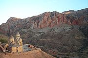
List of gorges
- Aragvi River GorgeAragvi RiverThe Aragvi River and its basin is located in Georgia on the southern slope of the Caucasus Mountains. The river is 112 km in length. The basin covers an area 2,724 km² The ground strata is mostly sandstone, slate, and limestone. The hydro-electricity dam built on the river produces much of...
, Georgia (country)Georgia (country)Georgia is a sovereign state in the Caucasus region of Eurasia. Located at the crossroads of Western Asia and Eastern Europe, it is bounded to the west by the Black Sea, to the north by Russia, to the southwest by Turkey, to the south by Armenia, and to the southeast by Azerbaijan. The capital of... - Avon GorgeAvon GorgeThe Avon Gorge is a 1.5-mile long gorge on the River Avon in Bristol, England. The gorge runs south to north through a limestone ridge west of Bristol city centre, and about 3 miles from the mouth of the river at Avonmouth. The gorge forms the boundary between the unitary authorities of...
, BristolBristolBristol is a city, unitary authority area and ceremonial county in South West England, with an estimated population of 433,100 for the unitary authority in 2009, and a surrounding Larger Urban Zone with an estimated 1,070,000 residents in 2007...
, England - Bog Walk Gorge, Saint Catherine Parish, Jamaica
- Bued Gorge, BenguetBenguetBenguet is a landlocked province of the Philippines in the Cordillera Administrative Region in Luzon. Its capital is La Trinidad and borders, clockwise from the south, Pangasinan, La Union, Ilocos Sur, Mountain Province, Ifugao, and Nueva Vizcaya....
, Philippines - Buller GorgeBuller GorgeThe Buller Gorge is a gorge located in the northwest of the South Island of New Zealand. The Buller River flows through the deep canyon between Murchison and Westport. Land Information New Zealand lists two sections for the gorge, Upper Buller Gorge and Lower Buller Gorge. State Highway 6 runs...
, BullerBuller District200px|rightBuller District, administered by the Buller District Council is an administrative region in the West Coast Region of New Zealand. It covers Westport, Karamea, Reefton and Inangahua Junction. Its land area is 7,953.12 km²...
, New Zealand - Cataract GorgeCataract GorgeThe Cataract Gorge is a river gorge in Launceston, northern Tasmania, Australia and is one of the region's premier tourist attractions. It is found at the lower section of the South Esk River...
, LauncestonLaunceston, TasmaniaLaunceston is a city in the north of the state of Tasmania, Australia at the junction of the North Esk and South Esk rivers where they become the Tamar River. Launceston is the second largest city in Tasmania after the state capital Hobart...
, Australia - Cheddar Gorge, SomersetSomersetThe ceremonial and non-metropolitan county of Somerset in South West England borders Bristol and Gloucestershire to the north, Wiltshire to the east, Dorset to the south-east, and Devon to the south-west. It is partly bounded to the north and west by the Bristol Channel and the estuary of the...
, England - Chovar Gorge, Kathmandu, NepalNepalNepal , officially the Federal Democratic Republic of Nepal, is a landlocked sovereign state located in South Asia. It is located in the Himalayas and bordered to the north by the People's Republic of China, and to the south, east, and west by the Republic of India...
- Columbia River GorgeColumbia River GorgeThe Columbia River Gorge is a canyon of the Columbia River in the Pacific Northwest of the United States. Up to deep, the canyon stretches for over as the river winds westward through the Cascade Range forming the boundary between the State of Washington to the north and Oregon to the south...
, OregonOregonOregon is a state in the Pacific Northwest region of the United States. It is located on the Pacific coast, with Washington to the north, California to the south, Nevada on the southeast and Idaho to the east. The Columbia and Snake rivers delineate much of Oregon's northern and eastern...
/Washington USA - Corrieshalloch GorgeCorrieshalloch GorgeCorrieshalloch Gorge is situated on the Droma River 20 km S of Ullapool in the Scottish Highlands. It is 1.5 km long, 60m deep and formed at the end of the last ice age by rapid erosion caused by meltwater. The 46m Falls of Measach can be viewed from a viewing platform and a Victorian...
, UllapoolUllapoolUllapool is a small town of around 1,300 inhabitants in Ross and Cromarty, Highland, Scotland. Despite its small size, it is the largest settlement for many miles around, and is a major tourist destination of Scotland. The North Atlantic Drift passes by Ullapool, bringing moderate temperatures...
, Scotland - Galston GorgeGalston GorgeGalston Gorge is part of the picturesque Berowra Valley Regional Park in Sydney, Australia and separates Galston from Hornsby Heights. It contains a narrow stretch of road with a one-way wooden bridge across Tunks Creek, a tributary of Berowra Creek. Here traffic must wait for cars already on the...
, NSWNew South WalesNew South Wales is a state of :Australia, located in the east of the country. It is bordered by Queensland, Victoria and South Australia to the north, south and west respectively. To the east, the state is bordered by the Tasman Sea, which forms part of the Pacific Ocean. New South Wales...
, Australia - Gorropu, SardiniaSardiniaSardinia is the second-largest island in the Mediterranean Sea . It is an autonomous region of Italy, and the nearest land masses are the French island of Corsica, the Italian Peninsula, Sicily, Tunisia and the Spanish Balearic Islands.The name Sardinia is from the pre-Roman noun *sard[],...
, Italy - Ironbridge GorgeIronbridge GorgeThe Ironbridge Gorge is a deep gorge formed by the River Severn in Shropshire, England.Originally called the Severn Gorge, the gorge now takes its name from its famous Iron Bridge, the first iron bridge of its kind in the world, and a monument to the industry that began there...
, ShropshireShropshireShropshire is a county in the West Midlands region of England. For Eurostat purposes, the county is a NUTS 3 region and is one of four counties or unitary districts that comprise the "Shropshire and Staffordshire" NUTS 2 region. It borders Wales to the west...
, England - Kali Gandaki GorgeKali Gandaki GorgeThe Kali Gandaki Gorge or Andha Galchi is the gorge of the Kali Gandaki in the Himalayas in Nepal, by some measures the deepest gorge in the world....
, GandakiGandakiGandaki may refer to:*Gandaki River, Nepal*Gandaki Zone, Nepal...
, NepalNepalNepal , officially the Federal Democratic Republic of Nepal, is a landlocked sovereign state located in South Asia. It is located in the Himalayas and bordered to the north by the People's Republic of China, and to the south, east, and west by the Republic of India... - Kloof, KwaZulu-NatalKloof, KwaZulu-NatalKloof is a leafy, middle- to upper class suburb and small town, that includes a smaller area called Everton, in the greater Durban area of eThekwini in KwaZulu-Natal, South Africa....
, South AfricaSouth AfricaThe Republic of South Africa is a country in southern Africa. Located at the southern tip of Africa, it is divided into nine provinces, with of coastline on the Atlantic and Indian oceans...
(The word Kloof means 'gorge' in AfrikaansAfrikaansAfrikaans is a West Germanic language, spoken natively in South Africa and Namibia. It is a daughter language of Dutch, originating in its 17th century dialects, collectively referred to as Cape Dutch .Afrikaans is a daughter language of Dutch; see , , , , , .Afrikaans was historically called Cape...
) - Komati GorgeKomati GorgeKomati Gorge is a river valley in the Mpumalanga Province in central South Africa, which features vertical sandstone cliffs that provide habitat for a wide diversity of wildlife. Komati Gorge is located near the communities of Carolina and Machadodorp...
, South Africa - Lanner GorgeLanner GorgeThe Lanner Gorge is located in the far North of the Kruger National Park. It forms the boundary between the Kruger National Park to the South and the Makuleke Concession to the North...
, South Africa - Letchworth State ParkLetchworth State ParkLetchworth State Park is a New York state park located 35 miles southwest of Rochester and 60 miles southeast of Buffalo in Livingston and Wyoming counties. The park is roughly 17 miles long, covering of land along the Genesee River...
(Genesee River Gorge), New YorkNew YorkNew York is a state in the Northeastern region of the United States. It is the nation's third most populous state. New York is bordered by New Jersey and Pennsylvania to the south, and by Connecticut, Massachusetts and Vermont to the east...
, USA - Linville Gorge WildernessLinville Gorge WildernessThe Linville Gorge Wilderness is the third largest wilderness area in North Carolina and one of only two wilderness gorges in the Southern United States...
, North CarolinaNorth CarolinaNorth Carolina is a state located in the southeastern United States. The state borders South Carolina and Georgia to the south, Tennessee to the west and Virginia to the north. North Carolina contains 100 counties. Its capital is Raleigh, and its largest city is Charlotte...
, USA - Manawatu GorgeManawatu GorgeThe Manawatu Gorge runs between the Ruahine and Tararua Ranges of the North Island of New Zealand, linking the Manawatu and Hawke's Bay regions...
, Manawatu, North Island, New Zealand - Montalban Gorge, Philippines
- New River GorgeNew River Gorge National RiverThe New River Gorge National River is a unit of the United States National Park Service designed to protect and maintain the New River Gorge in southern West Virginia. Established in 1978, the NPS-protected area stretches for from just downstream of Hinton to Hawks Nest State Park near Ansted.New...
, West Virginia, USA - Niagara GorgeNiagara FallsThe Niagara Falls, located on the Niagara River draining Lake Erie into Lake Ontario, is the collective name for the Horseshoe Falls and the adjacent American Falls along with the comparatively small Bridal Veil Falls, which combined form the highest flow rate of any waterfalls in the world and has...
, Canada/USA - North and South Gorges of North Stradbroke IslandNorth Stradbroke IslandNorth Stradbroke Island is an Australian island in the state of Queensland, 30 km southeast of the capital Brisbane. Before 1896 the island was part of the Stradbroke Island. In that year a storm separated it from South Stradbroke Island, forming the Jumpinpin Channel. It is known...
, QLDQueenslandQueensland is a state of Australia, occupying the north-eastern section of the mainland continent. It is bordered by the Northern Territory, South Australia and New South Wales to the west, south-west and south respectively. To the east, Queensland is bordered by the Coral Sea and Pacific Ocean...
, Australia - Katherine Gorge of Nitmiluk National ParkNitmiluk National ParkNitmiluk National Park which is in the Northern Territory of Australia, 244 km southeast of Darwin, has been established around a series of gorges on the Katherine River and Edith Falls...
in Australia - Pankisi GorgePankisi GorgeThe Pankisi Gorge or Pankisi is a valley region in Georgia, in the northeastern corner of the country, bordering the Chechnyan republic of the Russian Federation. Administratively, it is included in the Akhmeta district of the Kakheti region...
, Georgia (country)Georgia (country)Georgia is a sovereign state in the Caucasus region of Eurasia. Located at the crossroads of Western Asia and Eastern Europe, it is bounded to the west by the Black Sea, to the north by Russia, to the southwest by Turkey, to the south by Armenia, and to the southeast by Azerbaijan. The capital of... - Pine Creek GorgePine Creek GorgePine Creek Gorge, also known as, The Grand Canyon of Pennsylvania, is situated in approximately 160,000 acres of the Tioga State Forest in the U.S. State of Pennsylvania along Pine Creek. The Canyon begins south of Ansonia, near Wellsboro, along U.S. Route 6 and continues for approximately...
, Pennsylvania, USA - Quechee Gorge, Vermont, USA
- Red River GorgeRed River GorgeThe Red River Gorge is a canyon system on the Red River in east-central Kentucky. Geologically, it is part of the Pottsville Escarpment.Much of the Gorge is located inside the Daniel Boone National Forest and has been subsequently reserved as the Red River Gorge Geological Area, an area of around...
, Kentucky, USA - Richtis GorgeRichtis GorgeRichtis Gorge refers to a gorge in Crete, Greece . It is a state protected park near Exo Mouliana, Sitia, eastern Crete that starts at the traditional village Exo Mouliana, which is located on the national road between Agios Nikolaos and Sitia and ends at the secluded Richtis beach, just east of...
, CreteCreteCrete is the largest and most populous of the Greek islands, the fifth largest island in the Mediterranean Sea, and one of the thirteen administrative regions of Greece. It forms a significant part of the economy and cultural heritage of Greece while retaining its own local cultural traits...
, Greece - Rio Grande GorgeRio Grande GorgeThe Rio Grande Gorge runs from northwest to southeast of Taos, New Mexico, through the basalt flows of the Taos Plateau volcanic field. The gorge depth is 800 feet just south of the Gorge Bridge, which spans the gorge ten miles northwest of Taos....
, New MexicoNew MexicoNew Mexico is a state located in the southwest and western regions of the United States. New Mexico is also usually considered one of the Mountain States. With a population density of 16 per square mile, New Mexico is the sixth-most sparsely inhabited U.S...
, USA - Royal GorgeRoyal GorgeThe Royal Gorge is a canyon on the Arkansas River near Cañon City, Colorado. With a width of at its base and a few hundred feet at its top, and a depth of in places, the 10-mile-long canyon is a narrow, steep gorge through the granite of Fremont Peak...
, Colorado, USA - Samaria GorgeSamaria GorgeThe Samariá Gorge is aNational Park of Greece on the island of Crete - a major tourist attraction of the island - and a World's Biosphere Reserve....
, CreteCreteCrete is the largest and most populous of the Greek islands, the fifth largest island in the Mediterranean Sea, and one of the thirteen administrative regions of Greece. It forms a significant part of the economy and cultural heritage of Greece while retaining its own local cultural traits...
, Greece - SiqSiqal-Siq is the main entrance to the ancient city of Petra in southern Jordan. The dim, narrow gorge winds its way approximately one mile and ends at Petra's most elaborate ruin, Al Khazneh .The Siq is a natural geological fault produced by tectonic forces and worn smooth by water erosion...
, PetraPetraPetra is a historical and archaeological city in the Jordanian governorate of Ma'an that is famous for its rock cut architecture and water conduits system. Established sometime around the 6th century BC as the capital city of the Nabataeans, it is a symbol of Jordan as well as its most visited...
, Jordan - Talari GorgesTalari GorgesThe Talari Gorges or Gorges de Talary are a series of gorges on the Sénégal River in Mali, between the towns of Bafoulabé and Galougo in the Kayes Region, at an altitude of about 75 meters or 249 feet above sea level. They are celebrated for their grandiose beauty. Downstream, to the...
, MaliMaliMali , officially the Republic of Mali , is a landlocked country in Western Africa. Mali borders Algeria on the north, Niger on the east, Burkina Faso and the Côte d'Ivoire on the south, Guinea on the south-west, and Senegal and Mauritania on the west. Its size is just over 1,240,000 km² with... - Tallulah GorgeTallulah GorgeThe Tallulah Gorge is a gorge that is formed by the Tallulah River cutting through the Tallulah Dome rock formation. The gorge is approximately long and features rocky cliffs up to high. Through it, a series of falls known as Tallulah Falls, drop a total of in one mile...
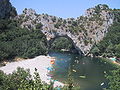
, Georgia, USA - Gorges du TarnGorges du TarnThe Gorges du Tarn is a canyon formed by the Tarn River between the Causse Méjean and the Causse de Sauveterre, in southern France. The canyon, mainly located in the Lozère département, and partially in the Aveyron département, is about -long and 400m to 600m deep.-Geography:The architecture of...
, France - Taroko Gorge of Taroko National ParkTaroko National ParkTaroko National Park is one of the seven national parks in Taiwan and was named after the Taroko Gorge, the landmark gorge of the park. The park spans Taichung City, Nantou County, and Hualien County....
, Taiwan - Three Gorges, ChongqingChongqingChongqing is a major city in Southwest China and one of the five national central cities of China. Administratively, it is one of the PRC's four direct-controlled municipalities , and the only such municipality in inland China.The municipality was created on 14 March 1997, succeeding the...
, China - Tiger Leaping GorgeTiger Leaping GorgeTiger Leaping Gorge is a canyon on the Yangtze River – locally called the Golden Sands River – located 60 km north of Lijiang City, Yunnan in southwestern China...
, YunnanYunnanYunnan is a province of the People's Republic of China, located in the far southwest of the country spanning approximately and with a population of 45.7 million . The capital of the province is Kunming. The province borders Burma, Laos, and Vietnam.Yunnan is situated in a mountainous area, with...
, China - Verdon GorgeVerdon GorgeThe Verdon Gorge , in south-eastern France , is a river canyon that is often considered to be one of Europe's most beautiful. It is about 25 kilometres long and up to 700 metres deep...
, ProvenceProvenceProvence ; Provençal: Provença in classical norm or Prouvènço in Mistralian norm) is a region of south eastern France on the Mediterranean adjacent to Italy. It is part of the administrative région of Provence-Alpes-Côte d'Azur...
, France - ViamalaViamalaViamala or Via Mala is an ancient and notorious section of the Hinterrhein River between Zillis-Reischen and Thusis in the Canton of Graubünden...
, GraubündenGraubündenGraubünden or Grisons is the largest and easternmost canton of Switzerland. The canton shares borders with the cantons of Ticino, Uri, Glarus and St. Gallen and international borders with Italy, Austria and Liechtenstein...
, Switzerland - Vikos GorgeVikos GorgeThe Vikos Gorge is a gorge in the Pindus Mountains of northern Greece. It lies on the southern slopes of Mount Tymfi, with a length of about 20 km, depth ranging from 450 m to 1600 m and width from 400 m to some meters at its narrowest part....
, Vikos–Aoös National Park, Greece
List of other features causing gorges or canyons
- Ardèche River, France
- Bued River, Philippines
- Danube River, Europe, including the Iron GateIron Gate (Danube)The Iron Gates The gorge lies between Romania in the north and Serbia in the south. At this point, the river separates the southern Carpathian Mountains from the northwestern foothills of the Balkan Mountains. The Romanian, Hungarian, Slovakian, Turkish, German and Bulgarian names literally mean...
- RuinaultaRuinaultaRuinaulta is a canyon created by the Vorderrhein in the debris of the Flims Rockslide just upstream of its confluence with the Hinter Rhine at Reichenau, Eastern Switzerland. It is sometimes known as the Rhine Canyon, or Swiss Grand Canyon...
, cutting Flims RockslideFlims RockslideFlims Rockslide occurred some 10000 years ago. It is known as the biggest Landslide incident in the Alps and the biggest worldwide whose effects are still visible, moving some of rock, about 300 times that of the historic Swiss Goldau landslide. The town of Flims can be found at the line where...
, Switzerland - Kings RiverKings River (California)The Kings River is a major river of south-central California. About long, it drains an area of the high western Sierra Nevada and the Central Valley. A large alluvial fan has formed where the river's gradient decreases in the Central Valley so the river divides into distributaries...
of the Kings Canyon National ParkKings Canyon National ParkKings Canyon National Park is a National Park in the southern Sierra Nevada, east of Fresno, California. The park was established in 1940 and covers...
, California, USA - South Nahanni RiverSouth Nahanni RiverThe South Nahanni River is a major tributary of the Liard River, located roughly 500 kilometres west of Yellowknife in the Northwest Territories of Canada. It is the centerpiece of Nahanni National Park Reserve...
in CanadaCanadaCanada is a North American country consisting of ten provinces and three territories. Located in the northern part of the continent, it extends from the Atlantic Ocean in the east to the Pacific Ocean in the west, and northward into the Arctic Ocean...
http://www.chrs.ca/Rivers/SouthNahanni/SouthNahanni-F_e.htm - Steall WaterfallSteall WaterfallThe spectacular waterfall known variously as An Steall Bàn, Steall Waterfall or Steall Falls is situated in Glen Nevis near Fort William, Highland, Scotland. It is Britain's second highest waterfall with a single drop of 120 metres...
of Glen NevisGlen NevisGlen Nevis is a glen in Lochaber, Highland, Scotland, with Fort William at its foot. It is bordered to the south by the Mamore range, and to the north by the highest mountains in the British Isles: Ben Nevis, Càrn Mor Dearg, Aonach Mòr, and Aonach Beag...
, LochaberLochaberDistrict of Lochaber 1975 to 1996Highland council area shown as one of the council areas of ScotlandLochaber is one of the 16 ward management areas of the Highland Council of Scotland and one of eight former local government districts of the two-tier Highland region...
, Scotland - Gorges de Hérault, France
- Sierra y Cañones de GuaraSierra de GuaraThe Sierra de Guara is a mountain massif in the province of Huesca, the most northerly province in the autonomous community of Aragon, Spain. Its highest point is Tozal de Guara .It lies around 25km northeast of the city of Huesca itself...
, Alquezar, Spain.
Canyons on other planetary bodies
- Valles MarinerisValles MarinerisValles Marineris is a system of canyons that runs along the Martian surface east of the Tharsis region...
on MarsMarsMars is the fourth planet from the Sun in the Solar System. The planet is named after the Roman god of war, Mars. It is often described as the "Red Planet", as the iron oxide prevalent on its surface gives it a reddish appearance...
, the largest known canyon in the solar system - Ithaca ChasmaIthaca ChasmaIthaca Chasma is a valley on Saturn's moon Tethys, named after the island of Ithaca, in Greece. It is on average 100 km wide, 3 to 5 km deep and 2,000 km long, running approximately three-quarters of the way around Tethys' circumference, making it one of the longer valleys in the...
on SaturnSaturnSaturn is the sixth planet from the Sun and the second largest planet in the Solar System, after Jupiter. Saturn is named after the Roman god Saturn, equated to the Greek Cronus , the Babylonian Ninurta and the Hindu Shani. Saturn's astronomical symbol represents the Roman god's sickle.Saturn,...
's moon TethysTethys (moon)Tethys or Saturn III is a mid-sized moon of Saturn about across. It was discovered by G. D. Cassini in 1684 and is named after titan Tethys of Greek mythology. Tethys is pronounced |Odysseus]] is about 400 km in diameter, while the largest graben—Ithaca Chasma is about 100 km wide and...
Venus has many craters and canyons on its surface. The troughs on the planet are part of a system of canyons that is more than 6 400 km long.
See also
- Antecedent drainage streamAntecedent drainage streamAn antecedent stream or antecedent drainage is a stream that follows a course that formed before the tectonic uplift of the surrounding terrain and maintained its course through continuous downcutting of its valley. Also referred to as a "superposed stream."...
- CanyoningCanyoningCanyoning is traveling in canyons using a variety of techniques that may include other outdoor activities such as walking, scrambling, climbing, jumping, abseiling, and/or swimming....
- DallesDallesDalles is the plural form of the French dalle, usually translated as a flagstone or paving-stone but with other meanings, including a drain-gutter on the bridge of a ship. In the combination dalles des morts it usually means a gravestone. In voyageur French, it came to mean a rapids or narrows on...
- Draw (terrain)Draw (terrain)A draw a terrain feature formed by two parallel ridges or spurs with low ground in between them. The area of low ground itself is the draw, and it is defined by the spurs surrounding it...
- GeomorphologyGeomorphologyGeomorphology is the scientific study of landforms and the processes that shape them...
- GullyGullyA gully is a landform created by running water, eroding sharply into soil, typically on a hillside. Gullies resemble large ditches or small valleys, but are metres to tens of metres in depth and width...
- List of landforms
- RavineRavineA ravine is a landform narrower than a canyon and is often the product of streamcutting erosion. Ravines are typically classified as larger in scale than gullies, although smaller than valleys. A ravine is generally a fluvial slope landform of relatively steep sides, on the order of twenty to...