
Umatilla National Forest
Encyclopedia
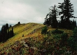
The Umatilla National Forest, in the Blue Mountains
of northeast Oregon
and southeast Washington, covers an area of 1.4 million acres (5,700 km²). In descending order of land area the forest is located in parts of Umatilla
, Grant
, Columbia, Morrow
, Wallowa
, Union
, Garfield, Asotin, Wheeler
, and Walla Walla counties. (Columbia, Garfield, Asotin, and Walla Walla counties are in Washington, while the rest are in Oregon.) More than three-quarters of the forest lies in the state of Oregon. Forest headquarters are located in Pendleton, Oregon
. There are local ranger
district offices in Heppner
and Ukiah
in Oregon, and in Pomeroy
and Walla Walla
in Washington.
 The Umatilla National Forest takes its name from the Umatilla Indian
word meaning "water rippling over sand." Explorers Lewis and Clark passed through the area in 1805 on the Columbia River
, and Marcus and Narcissa Whitman
passed through in 1836 to establish a mission at Wailatpu near Walla Walla, Washington
. Thousands of emigrants later followed the Oregon Trail
west, and many remained in the Blue Mountain region. Discovery of gold in Oregon in 1851 led to the settlement of the North Fork John Day River area. More than $10 million in gold and silver were mined, and remnants of the era are still visible in the National Forest. Some claims are still being mined.
Umatilla was established on July 1, 1908 from part of Blue Mountains National Forest
and all of Heppner National Forest
. Wenaha National Forest
was added on November 5, 1920.
, mountain goat, mule deer
, whitetail deer, grey wolf, cougar, coyote, badger, Merriam's turkeys, transplanted wild rio grande turkeys, blue
and ruffed grouse
, Franklin's grouse, chinook salmon
, silver salmon, steelhead, rainbow trout
., brook trout, and lake trout.
Spout Springs Ski Area in Oregon and Bluewood Ski Area
in Washington operate under special use permit within the forest.
Blue Mountains (Oregon)
The Blue Mountains are a mountain range in the western United States, located largely in northeastern Oregon and stretching into southeastern Washington...
of northeast Oregon
Oregon
Oregon is a state in the Pacific Northwest region of the United States. It is located on the Pacific coast, with Washington to the north, California to the south, Nevada on the southeast and Idaho to the east. The Columbia and Snake rivers delineate much of Oregon's northern and eastern...
and southeast Washington, covers an area of 1.4 million acres (5,700 km²). In descending order of land area the forest is located in parts of Umatilla
Umatilla County, Oregon
Umatilla County is a county located in the U.S. state of Oregon. It is included in the 8 county definition of Eastern Oregon. The county is named for the Umatilla River. In 2010, its population was 75,889...
, Grant
Grant County, Oregon
Grant County is a county located in the U.S. state of Oregon. It is included in the 8 county definition of Eastern Oregon. In 2010, its population was 7,445. It is named for President Ulysses S. Grant, who served as an army officer in the Oregon Territory, and at the time of the county's creation...
, Columbia, Morrow
Morrow County, Oregon
Morrow County is a county located in the U.S. state of Oregon, on the south side of the Columbia River. It is included in the 8 county definition of Eastern Oregon. The county is named for one of its first white settlers, Jackson L. Morrow, who was a member of the state legislature when the county...
, Wallowa
Wallowa County, Oregon
Wallowa County is a county located in the U.S. state of Oregon. It is included in the 8 county definition of Eastern Oregon. According to Oregon Geographic Names, the origins of the county's name are uncertain, with the most likely explanation being that it is derived from the Nez Perce term for a...
, Union
Union County, Oregon
Union County is a county located in the U.S. state of Oregon. It is included in the 8 county definition of Eastern Oregon. The county is named for the town of Union, which is located within its boundaries; in 2010, the county population was 25,748. The county seat is La Grande.-History:Union County...
, Garfield, Asotin, Wheeler
Wheeler County, Oregon
As of the census of 2000, there were 1,547 people, 653 households, and 444 families residing in the county. The population density was 1 people per square mile . There were 842 housing units at an average density of 0 per square mile...
, and Walla Walla counties. (Columbia, Garfield, Asotin, and Walla Walla counties are in Washington, while the rest are in Oregon.) More than three-quarters of the forest lies in the state of Oregon. Forest headquarters are located in Pendleton, Oregon
Pendleton, Oregon
Pendleton is a city in Umatilla County, Oregon, United States. Pendleton was named in 1868 by the county commissioners for George H. Pendleton, Democratic candidate for Vice-President in the 1864 presidential campaign. The population was 16,612 at the 2010 census...
. There are local ranger
National Park Ranger
National Park Service Rangers are among the uniformed employees charged with protecting and preserving areas set aside in the National Park System by the United States Congress and/or the President of the United States...
district offices in Heppner
Heppner, Oregon
The city of Heppner is the county seat of Morrow County, Oregon, United States. It was originally called Standsbury Flat for George W. Standsbury, one of the first white settlers in the area. It was later renamed to honor Henry Heppner, a Jewish pioneer who opened the first general store there in...
and Ukiah
Ukiah, Oregon
Ukiah is a city in Umatilla County, Oregon, United States. The population was 255 at the 2000 census. It is part of the Pendleton–Hermiston Micropolitan Statistical Area.-Geography:...
in Oregon, and in Pomeroy
Pomeroy, Washington
Pomeroy is a city in Garfield County, Washington, United States. The population was 1,425 at the 2010 census. It is the county seat of Garfield County.-Geography: Pomeroy is located at ....
and Walla Walla
Walla Walla, Washington
Walla Walla is the largest city in and the county seat of Walla Walla County, Washington, United States. The population was 31,731 at the 2010 census...
in Washington.
Human history
Umatilla (tribe)
The Umatilla are a Sahaptin-speaking Native American group living on the Umatilla Indian Reservation, who traditionally inhabited the Columbia Plateau region of the northwestern United States....
word meaning "water rippling over sand." Explorers Lewis and Clark passed through the area in 1805 on the Columbia River
Columbia River
The Columbia River is the largest river in the Pacific Northwest region of North America. The river rises in the Rocky Mountains of British Columbia, Canada, flows northwest and then south into the U.S. state of Washington, then turns west to form most of the border between Washington and the state...
, and Marcus and Narcissa Whitman
Marcus Whitman
Marcus Whitman was an American physician and Oregon missionary in the Oregon Country. Along with his wife Narcissa Whitman he started a mission in what is now southeastern Washington state in 1836, which would later become a stop along the Oregon Trail...
passed through in 1836 to establish a mission at Wailatpu near Walla Walla, Washington
Walla Walla, Washington
Walla Walla is the largest city in and the county seat of Walla Walla County, Washington, United States. The population was 31,731 at the 2010 census...
. Thousands of emigrants later followed the Oregon Trail
Oregon Trail
The Oregon Trail is a historic east-west wagon route that connected the Missouri River to valleys in Oregon and locations in between.After 1840 steam-powered riverboats and steamboats traversing up and down the Ohio, Mississippi and Missouri rivers sped settlement and development in the flat...
west, and many remained in the Blue Mountain region. Discovery of gold in Oregon in 1851 led to the settlement of the North Fork John Day River area. More than $10 million in gold and silver were mined, and remnants of the era are still visible in the National Forest. Some claims are still being mined.
Umatilla was established on July 1, 1908 from part of Blue Mountains National Forest
Blue Mountains National Forest
Blue Mountains National Forest was established as the Blue Mountains Forest Reserve by the U.S. Forest Service in Oregon on March 15, 1906 with from portions of the Baker City Forest Reserve and other lands. It became a National Forest on March 4, 1907...
and all of Heppner National Forest
Heppner National Forest
Heppner National Forest was established as the Heppner Forest Reserve by the U.S. Forest Service in Oregon on July 18, 1906 with . It became a National Forest on March 4, 1907. On July 1, 1908 the entire forest was combined with part of Blue Mountains National Forest to establish Umatilla...
. Wenaha National Forest
Wenaha National Forest
Wenaha National Forest was established as the Wenaha Forest Reserve by the U.S. Forest Service in Oregon and Washington on May 12, 1905 with . It became a National Forest on March 4, 1907. On November 5, 1920 the entire forest was transferred to Umatilla National Forest and the name was...
was added on November 5, 1920.
Wildlife
Common wildlife in the Umatilla National Forest include Shira's moose, rocky mountain elk, bighorn sheepBighorn Sheep
The bighorn sheep is a species of sheep in North America named for its large horns. These horns can weigh up to , while the sheep themselves weigh up to . Recent genetic testing indicates that there are three distinct subspecies of Ovis canadensis, one of which is endangered: Ovis canadensis sierrae...
, mountain goat, mule deer
Mule Deer
The mule deer is a deer indigenous to western North America. The Mule Deer gets its name from its large mule-like ears. There are believed to be several subspecies, including the black-tailed deer...
, whitetail deer, grey wolf, cougar, coyote, badger, Merriam's turkeys, transplanted wild rio grande turkeys, blue
Blue Grouse
The genus Dendragapus, contains two closely related species of grouse that have often been treated as a single variable taxon . The two species are the Dusky Grouse and the Sooty Grouse...
and ruffed grouse
Ruffed Grouse
The Ruffed Grouse is a medium-sized grouse occurring in forests from the Appalachian Mountains across Canada to Alaska. It is non-migratory.The Ruffed Grouse is frequently referred to as a "partridge"...
, Franklin's grouse, chinook salmon
Chinook salmon
The Chinook salmon, Oncorhynchus tshawytscha, is the largest species in the pacific salmon family. Other commonly used names for the species include King salmon, Quinnat salmon, Spring salmon and Tyee salmon...
, silver salmon, steelhead, rainbow trout
Rainbow trout
The rainbow trout is a species of salmonid native to tributaries of the Pacific Ocean in Asia and North America. The steelhead is a sea run rainbow trout usually returning to freshwater to spawn after 2 to 3 years at sea. In other words, rainbow trout and steelhead trout are the same species....
., brook trout, and lake trout.
Wilderness
More than 20 percent of the Umatilla National Forest is classified as wilderness:- Wenaha–Tucannon Wilderness, 177,400 acres (718 km²), straddles the border between Oregon and Washington.
- North Fork John Day WildernessNorth Fork John Day WildernessThe North Fork John Day Wilderness is a wilderness area within the Umatilla and Wallowa-Whitman National Forests, in the Blue Mountains of northeastern Oregon....
, 121,800 acres (493 km²), is in the southeast section of the National Forest. - North Fork Umatilla WildernessNorth Fork Umatilla WildernessThe North Fork Umatilla Wilderness is a wilderness area located inside the Umatilla National Forest, in the Blue Mountains of northeastern Oregon...
, 20,200 acres (82 km²), contains the narrow valley of the North Fork Umatilla River, the source of the Umatilla RiverUmatilla RiverThe Umatilla River is an tributary of the Columbia River in the U.S. state of Oregon. Draining a basin of , it enters the Columbia near the city of Umatilla in the northeastern part of the state...
.
Vegetation
A 1993 Forest Service study estimated that the extent of old growth in the forest was 190741 acres (77,190.2 ha)Recreation
Common recreational activities in the Umatilla National Forest include camping, hiking, fishing, hunting, wildlife watching, skiing, and rafting.Spout Springs Ski Area in Oregon and Bluewood Ski Area
Bluewood Ski Area
Ski Bluewood, formerly known as "Bluewood Ski Area," is an alpine ski area in southeastern Washington, United States. Located in Columbia County, at the northern end of the Blue Mountains in the Umatilla National Forest, the elevation at the base area is above sea level, with a summit of...
in Washington operate under special use permit within the forest.
External links
- Umatilla National Forest, USDA Forest Service