
.gif)
Northern Basin and Range (ecoregion)
Encyclopedia
United States Environmental Protection Agency
The U.S. Environmental Protection Agency is an agency of the federal government of the United States charged with protecting human health and the environment, by writing and enforcing regulations based on laws passed by Congress...
(EPA) in the U.S. states of Oregon
Oregon
Oregon is a state in the Pacific Northwest region of the United States. It is located on the Pacific coast, with Washington to the north, California to the south, Nevada on the southeast and Idaho to the east. The Columbia and Snake rivers delineate much of Oregon's northern and eastern...
, Idaho
Idaho
Idaho is a state in the Rocky Mountain area of the United States. The state's largest city and capital is Boise. Residents are called "Idahoans". Idaho was admitted to the Union on July 3, 1890, as the 43rd state....
, Nevada
Nevada
Nevada is a state in the western, mountain west, and southwestern regions of the United States. With an area of and a population of about 2.7 million, it is the 7th-largest and 35th-most populous state. Over two-thirds of Nevada's people live in the Las Vegas metropolitan area, which contains its...
, Utah
Utah
Utah is a state in the Western United States. It was the 45th state to join the Union, on January 4, 1896. Approximately 80% of Utah's 2,763,885 people live along the Wasatch Front, centering on Salt Lake City. This leaves vast expanses of the state nearly uninhabited, making the population the...
, and California
California
California is a state located on the West Coast of the United States. It is by far the most populous U.S. state, and the third-largest by land area...
. It contains dissected
Dissected plateau
A dissected plateau is a plateau area that has been severely eroded so that the relief is sharp. Such an area may be referred to as mountainous, but dissected plateaus are distinguishable from orogenic mountain belts by the lack of folding, metamorphism, extensive faulting, or magmatic activity...
lava plain
Lava plain
A lava plain, also called a lava field or lava bed, is a large expanse of nearly flat-lying lava flows. Such features are generally composed of highly-fluid basalt lava, and can extend for tens or even hundreds of miles across the underlying terrain...
s, rolling hill
Hill
A hill is a landform that extends above the surrounding terrain. Hills often have a distinct summit, although in areas with scarp/dip topography a hill may refer to a particular section of flat terrain without a massive summit A hill is a landform that extends above the surrounding terrain. Hills...
s, alluvial fan
Alluvial fan
An alluvial fan is a fan-shaped deposit formed where a fast flowing stream flattens, slows, and spreads typically at the exit of a canyon onto a flatter plain. A convergence of neighboring alluvial fans into a single apron of deposits against a slope is called a bajada, or compound alluvial...
s, valley
Valley
In geology, a valley or dale is a depression with predominant extent in one direction. A very deep river valley may be called a canyon or gorge.The terms U-shaped and V-shaped are descriptive terms of geography to characterize the form of valleys...
s, and scattered mountain range
Mountain range
A mountain range is a single, large mass consisting of a succession of mountains or narrowly spaced mountain ridges, with or without peaks, closely related in position, direction, formation, and age; a component part of a mountain system or of a mountain chain...
s in the northern part of the Great Basin
Great Basin
The Great Basin is the largest area of contiguous endorheic watersheds in North America and is noted for its arid conditions and Basin and Range topography that varies from the North American low point at Badwater Basin to the highest point of the contiguous United States, less than away at the...
. Although arid
Arid
A region is said to be arid when it is characterized by a severe lack of available water, to the extent of hindering or even preventing the growth and development of plant and animal life...
, the ecoregion
Ecoregion
An ecoregion , sometimes called a bioregion, is an ecologically and geographically defined area that is smaller than an ecozone and larger than an ecosystem. Ecoregions cover relatively large areas of land or water, and contain characteristic, geographically distinct assemblages of natural...
is higher and cooler than the Snake River Plain
Snake River Plain (ecoregion)
The Snake River Plain ecoregion is a Level III ecoregion designated by the United States Environmental Protection Agency in the U.S. states of Idaho and Oregon. It follows the Snake River across Idaho, stretching roughly from the Wyoming border to Eastern Oregon in the xeric intermontane west...
to the north and has more available moisture and a cooler climate
Climate
Climate encompasses the statistics of temperature, humidity, atmospheric pressure, wind, rainfall, atmospheric particle count and other meteorological elemental measurements in a given region over long periods...
than the Central Basin and Range to the south. Its southern boundary is determined by the highest shoreline of Pleistocene
Pleistocene
The Pleistocene is the epoch from 2,588,000 to 11,700 years BP that spans the world's recent period of repeated glaciations. The name pleistocene is derived from the Greek and ....
Lake Bonneville
Lake Bonneville
Lake Bonneville was a prehistoric pluvial lake that covered much of North America's Great Basin region. Most of the territory it covered was in present-day Utah, though parts of the lake extended into present-day Idaho and Nevada. Formed about 32,000 years ago, it existed until about 14,500 years...
, which once inundated the Central Basin and Range. The western part of the region is internally drained; its eastern stream network
Drainage basin
A drainage basin is an extent or an area of land where surface water from rain and melting snow or ice converges to a single point, usually the exit of the basin, where the waters join another waterbody, such as a river, lake, reservoir, estuary, wetland, sea, or ocean...
drains to the Snake River
Snake River
The Snake is a major river of the greater Pacific Northwest in the United States. At long, it is the largest tributary of the Columbia River, the largest North American river that empties into the Pacific Ocean...
system.
The valleys support sagebrush steppe
Sagebrush steppe
The sagebrush steppe is a type of shrub-steppe, which is a dry-xeric environment and plant community found in the Western United States and western Canada...
or saltbush vegetation. Mollisol soils
Mollisols
Mollisols are a soil order in USDA soil taxonomy. Mollisols form in semi-arid to semi-humid areas, typically under a grassland cover. They are most commonly found in the mid-latitudes, namely in North America, mostly east of the Rocky Mountains, in South America in Argentina and Brazil, and in...
are common, in contrast to the aridisols
Aridisols
Aridisols are a soil order in USA soil taxonomy. Aridisols form in an arid or semi-arid climate. Aridisols dominate the deserts and xeric shrublands, which occupy about one third of the Earth's land surface...
of the Central Basin. Juniper
Juniper
Junipers are coniferous plants in the genus Juniperus of the cypress family Cupressaceae. Depending on taxonomic viewpoint, there are between 50-67 species of juniper, widely distributed throughout the northern hemisphere, from the Arctic, south to tropical Africa in the Old World, and to the...
-dominated woodland
Woodland
Ecologically, a woodland is a low-density forest forming open habitats with plenty of sunlight and limited shade. Woodlands may support an understory of shrubs and herbaceous plants including grasses. Woodland may form a transition to shrubland under drier conditions or during early stages of...
occurs on rugged, stony uplands. The mountain ranges are covered in mountain sagebrush, Idaho fescue, Douglas-fir
Douglas-fir
Douglas-fir is one of the English common names for evergreen coniferous trees of the genus Pseudotsuga in the family Pinaceae. Other common names include Douglas tree, and Oregon pine. There are five species, two in western North America, one in Mexico, and two in eastern Asia...
, subalpine
Subalpine
The subalpine zone is the biotic zone immediately below tree line around the world. Species that occur in this zone depend on the location of the zone on the Earth, for example, Snow Gum in Australia, or Subalpine Larch, Mountain Hemlock and Subalpine Fir in western North America.Trees in the...
forests, or aspen
Aspen
Populus section Populus, of the Populus genus, includes the aspen trees and the white poplar Populus alba. The five typical aspens are all native to cold regions with cool summers, in the north of the Northern Hemisphere, extending south at high altitudes in the mountains. The White Poplar, by...
. Today, most of the region is used for livestock
Livestock
Livestock refers to one or more domesticated animals raised in an agricultural setting to produce commodities such as food, fiber and labor. The term "livestock" as used in this article does not include poultry or farmed fish; however the inclusion of these, especially poultry, within the meaning...
grazing
Grazing
Grazing generally describes a type of feeding, in which a herbivore feeds on plants , and also on other multicellular autotrophs...
. Dryland
Dryland farming
Dryland farming is an agricultural technique for non-irrigated cultivation of drylands.-Locations:Dryland farming is used in the Great Plains, the Palouse plateau of Eastern Washington, and other arid regions of North America, the Middle East and in other grain growing regions such as the steppes...
and irrigated cropland are found in some areas, but in general the soil
Soil
Soil is a natural body consisting of layers of mineral constituents of variable thicknesses, which differ from the parent materials in their morphological, physical, chemical, and mineralogical characteristics...
s are less suitable for agriculture
Agriculture
Agriculture is the cultivation of animals, plants, fungi and other life forms for food, fiber, and other products used to sustain life. Agriculture was the key implement in the rise of sedentary human civilization, whereby farming of domesticated species created food surpluses that nurtured the...
than those in the Columbia Plateau
Columbia Plateau (ecoregion)
The Columbia Plateau ecoregion is a Level III ecoregion designated by the United States Environmental Protection Agency in the U.S. states of Oregon and Washington, with small areas over the Washington state border in Idaho...
and the Snake River Plain ecoregions. Most public lands in the region are managed by the Bureau of Land Management
Bureau of Land Management
The Bureau of Land Management is an agency within the United States Department of the Interior which administers America's public lands, totaling approximately , or one-eighth of the landmass of the country. The BLM also manages of subsurface mineral estate underlying federal, state and private...
.
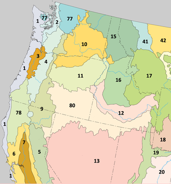
The Northern Basin and Range ecoregion has been subdivided into fourteen Level IV ecoregions, as described below. Level IV mapping is not yet complete in California, and the information below includes only the sections in Oregon, Idaho, Nevada, and Utah.
Level IV ecoregions
Dissected High Lava Plateau (80a)
The Dissected High Lava Plateau ecoregion is a broad to gently rolling basaltBasalt
Basalt is a common extrusive volcanic rock. It is usually grey to black and fine-grained due to rapid cooling of lava at the surface of a planet. It may be porphyritic containing larger crystals in a fine matrix, or vesicular, or frothy scoria. Unweathered basalt is black or grey...
plateau
Plateau
In geology and earth science, a plateau , also called a high plain or tableland, is an area of highland, usually consisting of relatively flat terrain. A highly eroded plateau is called a dissected plateau...
cut by deep, sheer-walled canyon
Canyon
A canyon or gorge is a deep ravine between cliffs often carved from the landscape by a river. Rivers have a natural tendency to reach a baseline elevation, which is the same elevation as the body of water it will eventually drain into. This forms a canyon. Most canyons were formed by a process of...
s, with perennial and intermittent streams draining to the Snake River. Elevation varies from 4,000 to 7,300 feet (1,219 to 2,225 m). The region is less wooded, lower, and more arid than neighboring subregions in the Northern Basin and Range. It differs from sagebrush-dominated regions in the Central Basin and Range in having higher precipitation
Precipitation (meteorology)
In meteorology, precipitation In meteorology, precipitation In meteorology, precipitation (also known as one of the classes of hydrometeors, which are atmospheric water phenomena is any product of the condensation of atmospheric water vapor that falls under gravity. The main forms of precipitation...
and colder winters. Potential natural vegetation is mostly sagebrush steppe; Wyoming big sagebrush and black sagebrush are abundant, as well as Douglas rabbitbrush, Idaho fescue, bluebunch wheatgrass
Bluebunch wheatgrass
Pseudoroegneria spicata is a species of grass known by the common name Bluebunch Wheatgrass. This native western North American perennial bunchgrass is known by the scientific synonyms Elymus spicatus and Agropyron spicatum. The grass can be found from Alaska to Texas. It occurs in many types of...
, western wheatgrass
Western Wheatgrass
Pascopyrum is a monotypic genus of grass containing the sole species Pascopyrum smithii, which is known by the common name western wheatgrass. This is a sod-forming rhizomatous perennial grass which is native and common in North America. It grows in grassland and prairie in the Great Plains, where...
, Thurber's needlegrass, bottlebrush squirreltail, Great Basin wildrye, Sandberg's bluegrass, Indian ricegrass
Indian ricegrass
Oryzopsis hymenoides is a perennial cool-season bunchgrass. It is native to western North America east of the Cascades from British Columbia and Alberta south to southern California, northeastern Mexico, and Texas...
, and cheatgrass. Juniper-pinyon
Pinyon pine
The pinyon pine group grows in the southwestern United States and in Mexico. The trees yield edible pinyon nuts, which were a staple of the Native Americans, and are still widely eaten...
woodlands grow on rocky and gravelly uplands. Understory
Understory
Understory is the term for the area of a forest which grows at the lowest height level below the forest canopy. Plants in the understory consist of a mixture of seedlings and saplings of canopy trees together with understory shrubs and herbs...
species are denser and biological soil crusts tend to be more extensive and in better condition than at similar elevations in the Central Basin and Range. Cheatgrass has replaced depleted bunchgrasses in overgrazed areas. One of the largest Northern Basin and Range subregions, the Dissected High Lava Plateau covers 5364 square miles (13,893 km²) in Idaho, 3984 square miles (10,319 km²) in Oregon, 3537 square miles (9,161 km²) in Nevada, and 412 square miles (1,067 km²) in Utah, including much of the Owyhee Desert
Owyhee Desert
The Owyhee Desert ecoregion, within the Deserts and xeric shrublands Biome, is in the Northwestern United States. The Owyhee Uplands Bypass passes through the desert.-Geography:...
. It is primarily used for rangeland
Rangeland
Rangelands are vast natural landscapes in the form of grasslands, shrublands, woodlands, wetlands, and deserts. Types of rangelands include tallgrass and shortgrass prairies, desert grasslands and shrublands, woodlands, savannas, chaparrals, steppes, and tundras...
and wildlife habitat. Contiguous areas in California have not been mapped yet.
Semiarid Hills and Low Mountains (80b)
The Semiarid Hills and Low Mountains ecoregion is higher and more rugged than the sagebrush plains and basins of neighboring regions. It is composed of unglaciatedGlacier
A glacier is a large persistent body of ice that forms where the accumulation of snow exceeds its ablation over many years, often centuries. At least 0.1 km² in area and 50 m thick, but often much larger, a glacier slowly deforms and flows due to stresses induced by its weight...
mountain slopes, hills, and alluvial fans at an elevation of 4,600 to 9,000 feet (1,402 to 2,743 m). The region is covered by mountain big sagebrush, low sagebrush, and associated grasses and understory plants, including bluebunch wheatgrass, Sandberg bluegrass, Great Basin wildrye, Indian ricegrass, cheatgrass, Idaho fescue, needle-and-thread grass, snowberry, and serviceberry
Serviceberry
Amelanchier , also known as shadbush, shadwood or shadblow, serviceberry or sarvisberry, wild pear, juneberry, saskatoon, sugarplum or wild-plum, and chuckley pear is a genus of about 20 species of deciduous-leaved shrubs and small trees in the Rose family .Amelanchier is native to temperate regions...
. Scattered juniper woodlands grow on shallow and rocky soils. These hills represent the northern limit for both pinyon and Utah juniper; western juniper replaces them to the west and north. Groves of aspen grow on alluvial fans and along stream networks, with some lodgepole pine
Lodgepole Pine
Lodgepole Pine, Pinus contorta, also known as Shore Pine, is a common tree in western North America. Like all pines, it is evergreen.-Subspecies:...
and Douglas-fir. Geyer willow and Booth willow are also present in riparian areas
Riparian zone
A riparian zone or riparian area is the interface between land and a river or stream. Riparian is also the proper nomenclature for one of the fifteen terrestrial biomes of the earth. Plant habitats and communities along the river margins and banks are called riparian vegetation, characterized by...
. The region includes stream
Stream
A stream is a body of water with a current, confined within a bed and stream banks. Depending on its locale or certain characteristics, a stream may be referred to as a branch, brook, beck, burn, creek, "crick", gill , kill, lick, rill, river, syke, bayou, rivulet, streamage, wash, run or...
s that have been designated for protection as critical or high priority habitat
Habitat
* Habitat , a place where a species lives and grows*Human habitat, a place where humans live, work or play** Space habitat, a space station intended as a permanent settlement...
for Yellowstone cutthroat trout
Yellowstone cutthroat trout
The Yellowstone cutthroat trout is a subspecies of the cutthroat trout and is a freshwater fish in the salmon family of the order Salmoniformes. Native only to a few U.S...
and other fish. Water quality has been lightly to moderately degraded by human activities, such as historic gold mining
Gold mining
Gold mining is the removal of gold from the ground. There are several techniques and processes by which gold may be extracted from the earth.-History:...
and livestock grazing, which is the primary land use today. The ecoregion covers 3567 square miles (9,238 km²) in Idaho, 1011 square miles (2,618 km²) in Nevada, and 479 square miles (1,241 km²) in Utah, including Shoshone
Shoshone
The Shoshone or Shoshoni are a Native American tribe in the United States with three large divisions: the Northern, the Western and the Eastern....
and Bannock
Bannock (tribe)
The Bannock tribe of the Northern Paiute are an indigenous people of the Great Basin. Their traditional lands include southeastern Oregon, southeastern Idaho, western Wyoming, and southwestern Montana...
land on the Fort Hall Indian Reservation
Fort Hall Indian Reservation
The Fort Hall Indian Reservation is an Indian reservation of the federally recognized Shoshone-Bannock Tribes in the U.S. state of Idaho. It is located in southeastern Idaho on the Snake River Plain north of Pocatello, and comprises 814.874 sq mi of land area in four counties: Bingham, Power,...
and public land within the Sawtooth
Sawtooth National Forest
Sawtooth National Forest is in Idaho and Utah was protected in 1905 by U.S. President Theodore Roosevelt as the Sawtooth Forest Reserve. Today the forest administers over 2.1 million acres of some of the most remote forestland in the lower 48 states, and there are over 1,000 lakes and 3,000...
and Caribou-Targhee
Caribou-Targhee National Forest
Caribou-Targhee National Forest is located in the states of Idaho and Wyoming, with a small section in Utah in the United States. The forest is broken into several separate sections and extends over . To the east the forest borders Yellowstone National Park, Grand Teton National Park and...
national forests.
High Elevation Forests and Shrublands (80c)
The High Elevation Forests and Shrublands ecoregion is composed of steep, rugged, unglaciated mountains with cold winters, at an elevation of 6,000 to 9,900 feet (1,829 to 3,018 m). It is characterized by a mix of conifers, mountain brush, and sagebrush grassland. North-facing slopes may support Douglas-fir, lodgepole pine, subalpine conifers, aspen, and snowberry. South-facing slopes may support mountain big sagebrush, serviceberry, snowberry, Idaho fescue, chokecherryChokecherry
Prunus virginiana, commonly called chokecherry, bitter-berry, or Virginia bird cherry, is a species of bird cherry native to North America, where it is found almost throughout the continent except for the Deep South and the far north.-Growth:It is a suckering shrub or small tree growing to 5 m tall...
, mountain brome
Bromus
Bromus is a large genus of the grass family . Estimates in the scientific literature of the number of species have ranged from 100 to 400, but plant taxonomists currently recognize around 160–170 species...
, bluegrass, and bluebunch wheatgrass. Open grassland grows on wide ridge
Ridge
A ridge is a geological feature consisting of a chain of mountains or hills that form a continuous elevated crest for some distance. Ridges are usually termed hills or mountains as well, depending on size. There are several main types of ridges:...
tops. Engelmann spruce
Engelmann Spruce
Picea engelmannii is a species of spruce native to western North America, from central British Columbia and southwest Alberta, southwest to northern California and southeast to Arizona and New Mexico; there are also two isolated populations in northern Mexico...
and subalpine fir
Subalpine Fir
The Subalpine Fir or Rocky Mountain Fir is a western North American fir, native to the mountains of Yukon, British Columbia and western Alberta in Canada; southeastern Alaska, Washington, Oregon, Idaho, western Montana, Wyoming, Utah, Colorado, New Mexico, Arizona, northeastern Nevada, and the...
may be found in upper canyon
Canyon
A canyon or gorge is a deep ravine between cliffs often carved from the landscape by a river. Rivers have a natural tendency to reach a baseline elevation, which is the same elevation as the body of water it will eventually drain into. This forms a canyon. Most canyons were formed by a process of...
s. The region covers 943 square miles (2,442 km²) in southeastern Idaho and 126 square miles (326 km²) in northwestern Utah, including land within the Sawtooth and Caribou-Targhee national forests.
Pluvial Lake Basins (80d)
The Pluvial Lake Basins ecoregion contained vast lakeLake
A lake is a body of relatively still fresh or salt water of considerable size, localized in a basin, that is surrounded by land. Lakes are inland and not part of the ocean and therefore are distinct from lagoons, and are larger and deeper than ponds. Lakes can be contrasted with rivers or streams,...
s during the Pleistocene epoch that have now mostly disappeared. It is characterized by gently sloping, internally drained basins with lake terraces, playas
Dry lake
Dry lakes are ephemeral lakebeds, or a remnant of an endorheic lake. Such flats consist of fine-grained sediments infused with alkali salts. Dry lakes are also referred to as alkali flats, sabkhas, playas or mud flats...
, beach plains, stream terrace
Stream terrace
Fluvial terraces are elongated terraces that flank the sides of floodplains and fluvial valleys all over the world. They consist of a relatively level strip of land, called a “tread,” separated from either an adjacent floodplain, other fluvial terraces, or uplands by distinctly steeper strips of...
s, intermittent lakes, fan skirts, and cool springs
Spring (hydrosphere)
A spring—also known as a rising or resurgence—is a component of the hydrosphere. Specifically, it is any natural situation where water flows to the surface of the earth from underground...
. Elevation varies from 4,200 to 6,200 feet (1,280 to 1,890 m). Some basin floor playas collect and evaporate water seasonally, but not as extensively as the High Desert Wetlands. Dry lake beds near the Cascade Mountains have a significant layer of volcanic ash
Volcanic ash
Volcanic ash consists of small tephra, which are bits of pulverized rock and glass created by volcanic eruptions, less than in diameter. There are three mechanisms of volcanic ash formation: gas release under decompression causing magmatic eruptions; thermal contraction from chilling on contact...
. Greasewood
Greasewood
Greasewood, Sarcobatus, is a genus of one or two species of flowering plants. Traditionally it has been treated in the family Chenopodiaceae, but the APG II system, of 2003, places it in the family Sarcobataceae....
, inland saltgrass, and seepweed grow in alkaline soils. Better drained, less alkaline soils are dominated by Wyoming big sagebrush and basin big sagebrush, with rubber rabbitbrush, Great Basin wildrye, bottlebrush squirreltail, Indian ricegrass, Sandberg's bluegrass, Thurber's needlegrass, and cheatgrass. The land is used for rangeland and sprinkler-irrigated alfalfa
Alfalfa
Alfalfa is a flowering plant in the pea family Fabaceae cultivated as an important forage crop in the US, Canada, Argentina, France, Australia, the Middle East, South Africa, and many other countries. It is known as lucerne in the UK, France, Australia, South Africa and New Zealand, and known as...
farming. The region covers 2092 square miles (5,418 km²) in Oregon and 342 square miles (886 km²) in Nevada.
High Desert Wetlands (80e)
The nearly level High Desert Wetlands ecoregion consists of high desertHigh Desert (Oregon)
The Oregon High Desert is a region of the U.S. state of Oregon, located east of the Cascade Range and south of the Blue Mountains, in the central and eastern parts of the state. Divided into a southern region and a northern region, the desert covers most of five Oregon counties and averages above...
lakes and surrounding wetland
Wetland
A wetland is an area of land whose soil is saturated with water either permanently or seasonally. Wetlands are categorised by their characteristic vegetation, which is adapted to these unique soil conditions....
s that provide critical habitat for nesting and migratory
Bird migration
Bird migration is the regular seasonal journey undertaken by many species of birds. Bird movements include those made in response to changes in food availability, habitat or weather. Sometimes, journeys are not termed "true migration" because they are irregular or in only one direction...
birds and associated upland birds and mammals. Elevation varies from 4,000 to 5,200 feet (1,219 to 1,646 m). The fine-textured soils are poorly drained, and basins collect water seasonally. Although water levels fluctuate from year to year, lakes and wetlands in this region hold water more consistently than on the coarser, better drained soils of the Pluvial Lake Basins. Sedges
Cyperaceae
Cyperaceae are a family of monocotyledonous graminoid flowering plants known as sedges, which superficially resemble grasses or rushes. The family is large, with some 5,500 species described in about 109 genera. These species are widely distributed, with the centers of diversity for the group...
, rushes
Scirpus
The plant genus Scirpus consists of a large number of aquatic, grass-like species in the family Cyperaceae , many with the common names club-rush or bulrush . Other common names are deergrass or grassweed.The genus has a cosmopolitan distribution, and grows in wetlands and moist soil...
, black greasewood, tufted hairgrass, mat muhly
Muhlenbergia
Muhlenbergia is a genus of grass in the Poaceae family. It is named in honour of the American amateur botanist Gotthilf Heinrich Ernst Muhlenberg. There are around 155 species. Many are known by the common name muhly....
, meadow barley, creeping wildrye
Leymus
Leymus is a genus of the true grass family . The common name for this genus is "wild rye"; however, members of the genus Elymus are also sometimes given the same common name...
, and Nevada bluegrass
Poa
Poa is a genus of about 500 species of grasses, native to the temperate regions of both hemispheres. Common names include meadow-grass , bluegrass , tussock , and speargrass. "Poa" is Greek for fodder...
occur in wetter areas. Drier areas support basin big sagebrush, Wyoming big sagebrush, silver sagebrush
Artemisia cana
Artemisia cana is a species of sagebrush native to western and central North America, having three subspecies. It known by many common names, including silver sagebrush, sticky sagebrush, silver wormwood, hoary sagebrush, and dwarf sagebrush...
, bluebunch wheatgrass, basin wildrye, Idaho fescue, Thurber's needlegrass, and cheatgrass. The region covers 1651 square miles (4,276 km²) in Oregon, including the Malheur National Wildlife Refuge
Malheur National Wildlife Refuge
Malheur National Wildlife Refuge is located roughly south of the town of Burns, Oregon. The refuge area is roughly T shaped with the southernmost base at Frenchglen, the left top at Malheur Lake and the right top at Harney Lake....
and land surrounding Malheur Lake
Malheur Lake
Malheur Lake is a lake in an arid region of eastern Oregon, United States near Burns, Oregon. The lake is fed by Donner und Blitzen River from the south and the Silvies River from the north. Malheur Lake has no outlet, though water escapes through ground seepage and by evaporation; widespread...
, Paulina Marsh, Summer Lake
Summer Lake (Oregon)
Summer Lake is a large, shallow, alkali lake in Lake County, Oregon, United States. It is approximately long and wide, and is located five miles south of the small, unincorporated community of Summer Lake, Oregon. The lake was named by explorer John C. Fremont on his expedition into Central...
, Lake Abert
Lake Abert
Lake Abert is a large, shallow, alkali lake in Lake County, Oregon, United States. It is approximately long and wide at its widest point. It is located northwest of the small, unincorporated community of Valley Falls, Oregon. The lake was named in honor of Colonel John James Abert by explorer...
, and the Warner Lakes. It also includes 105 square miles (272 km²) in Idaho and 56 square miles (145 km²) in Nevada, on and around the Duck Valley Indian Reservation
Duck Valley Indian Reservation
The Duck Valley Indian Reservation was established as a homeland for members of both the Shoshone and Paiute tribes of Native Americans. It lies directly on the state line between Idaho and Nevada in the western United States...
.
Owyhee Uplands and Canyons (80f)
The Owyhee Uplands and Canyons ecoregion is a sagebrush steppe containing deep river canyons, barren lava fields, badlandsBadlands
A badlands is a type of dry terrain where softer sedimentary rocks and clay-rich soils have been extensively eroded by wind and water. It can resemble malpaís, a terrain of volcanic rock. Canyons, ravines, gullies, hoodoos and other such geological forms are common in badlands. They are often...
, and tuffaceous outcrop
Outcrop
An outcrop is a visible exposure of bedrock or ancient superficial deposits on the surface of the Earth. -Features:Outcrops do not cover the majority of the Earth's land surface because in most places the bedrock or superficial deposits are covered by a mantle of soil and vegetation and cannot be...
s that are riddled by cave
Cave
A cave or cavern is a natural underground space large enough for a human to enter. The term applies to natural cavities some part of which is in total darkness. The word cave also includes smaller spaces like rock shelters, sea caves, and grottos.Speleology is the science of exploration and study...
s. Elevation varies from 2,500 to 6,600 feet (762 to 2,012 m). Although the region's climate and vegetation are similar to the Dissected High Lava Plateau, its lithology
Lithology
The lithology of a rock unit is a description of its physical characteristics visible at outcrop, in hand or core samples or with low magnification microscopy, such as colour, texture, grain size, or composition. It may be either a detailed description of these characteristics or be a summary of...
is more varied, stream density is higher, and water availability is greater. These attributes, combined with its remote location, make the region a particularly valuable refuge for wildlife. The steppe is characterized by Wyoming big sagebrush, basin big sagebrush, Douglas rabbitbrush, bluebunch wheatgrass, Idaho fescue, bottlebrush squirreltail, Sandberg's bluegrass, and cheatgrass. Rocky areas support scattered western juniper. It is mostly used for rangeland and wildlife habitat, with some hay and small grain farming. Cheatgrass has replaced depleted bunchgrasses in overgrazed areas. The region covers 2991 square miles (7,747 km²) in Oregon and 1293 square miles (3,349 km²) in Idaho, including Lake Owyhee and the Owyhee
Owyhee River
The Owyhee River is a tributary of the Snake River located in northern Nevada, southwestern Idaho and southeastern Oregon in the United States. It is long. The river's drainage basin is in area, one of the largest subbasins of the Columbia Basin...
, Malheur
Malheur River
The Malheur River is a tributary of the Snake River in eastern Oregon in the United States. It drains a high desert area, between the Harney Basin and the Blue Mountains and the Snake....
, and Succor
Succor Creek
Succor Creek is a tributary of the Snake River in the U.S. states of Idaho and Oregon. The creek begins in the Owyhee Mountains in Owyhee County, Idaho. After flowing for about in Idaho, Succor Creek enters Malheur County, Oregon, where it flows for before re-entering Idaho for its final...
drainages.
High Lava Plains (80g)
The High Lava Plains ecoregion is a vast, nearly level to undulating sagebrush steppe containing scattered volcanic coneVolcanic cone
Volcanic cones are among the simplest volcanic formations. They are built by ejecta from a volcanic vent, piling up around the vent in the shape of a cone with a central crater. Volcanic cones are of different types, depending upon the nature and size of the fragments ejected during the eruption...
s and butte
Butte
A butte is a conspicuous isolated hill with steep, often vertical sides and a small, relatively flat top; it is smaller than mesas, plateaus, and table landform tables. In some regions, such as the north central and northwestern United States, the word is used for any hill...
s. Elevation varies from 4,200 to 6,800 feet (1,280 to 2,073 m). The region is similar to the Dissected High Lava Plateau in its physiography, climate, and vegetation, but, unlike the plateau, it is internally drained. As a result, it lacks anadromous fish runs. It also differs from the plateau in having numerous intermittent lakes on the impermeable volcanic
Volcanic rock
Volcanic rock is a rock formed from magma erupted from a volcano. In other words, it is an igneous rock of volcanic origin...
bedrock
Bedrock
In stratigraphy, bedrock is the native consolidated rock underlying the surface of a terrestrial planet, usually the Earth. Above the bedrock is usually an area of broken and weathered unconsolidated rock in the basal subsoil...
. Vegetation on the steppe includes Wyoming big sagebrush, low sagebrush, mountain big sagebrush, Lahontan sagebrush, bluebunch wheatgrass, Sandberg's bluegrass, Thurber's needlegrass, bottlebrush squirreltail, and Idaho fescue. Silver sagebrush, creeping wildrye, and mat muhly are found in depressions
Depression (geology)
A depression in geology is a landform sunken or depressed below the surrounding area. Depressions may be formed by various mechanisms.Structural or tectonic related:...
. Shallow and rocky soils support scattered western juniper. The federally threatened
Endangered Species Act
The Endangered Species Act of 1973 is one of the dozens of United States environmental laws passed in the 1970s. Signed into law by President Richard Nixon on December 28, 1973, it was designed to protect critically imperiled species from extinction as a "consequence of economic growth and...
Warner sucker fish
Warner Sucker
The Warner Sucker is a rare species of ray-finned fish in the Catostomidae family. It is native to Oregon in the United States, where it is found only in the Warner Basin, its distribution extending just into Nevada and California. It is a federally listed threatened species...
lives in permanent, shallow, weedy lakes and spawns in Nevada's Twelvemile Creek. The Wall Canyon area supports a unique fish species, the Wall Canyon sucker
Catostomus
Catostomus is a genus of fish belonging to the family Catostomidae, commonly known as suckers.- Species :FishBase lists 27 species:* Catostomus ardens D. S. Jordan & C. H. Gilbert, 1881...
. Higher elevations once supported Lahontan cutthroat trout but water availability limits their present distribution. The largest of the Northern Basin and Range subregions, the High Lava Plains covers 10262 square miles (26,578 km²) in Oregon and 5740 square miles (14,867 km²) in Nevada, featuring a variety of land uses, including rangeland, wildlife habitat, irrigated pastureland and cropland, historic gold and silver mines, and active opal mines and clay quarries
Quarry
A quarry is a type of open-pit mine from which rock or minerals are extracted. Quarries are generally used for extracting building materials, such as dimension stone, construction aggregate, riprap, sand, and gravel. They are often collocated with concrete and asphalt plants due to the requirement...
. It contains the Sheldon National Wildlife Refuge
Sheldon National Wildlife Refuge
The Sheldon National Wildlife Refuge is a national wildlife refuge located on the northern border of the U.S. state of Nevada. A very small part extends northward into Oregon. It is managed by the United States Fish and Wildlife Service as the Nevada component of the Sheldon-Hart Mountain...
and lower elevations in the Hart Mountain National Antelope Refuge
Hart Mountain National Antelope Refuge
Hart Mountain National Antelope Refuge is a National Wildlife Refuge on Hart Mountain in southeastern Oregon, which protects more than and more than 300 species of wildlife, including pronghorn antelope, bighorn sheep, mule deer, sage grouse, and redband trout...
. Contiguous areas in California have not been mapped yet.
Saltbush-Dominated Valleys (80h)
The Saltbush-Dominated Valleys ecoregion, externally drained by the Snake River, is composed of gently sloping valley bottoms and alluvial fans dominated by salt-tolerant vegetation that distinguishes it from the sagebrush steppe of surrounding regions. Elevation varies from 4,500 to 6,000 feet (1,372 to 1,829 m). Light-colored soils with high salt and alkali content are common; they are dry for extended periods and may be leached of salt by irrigation water. Potential natural vegetation is mostly saltbush-greasewood, featuring Nuttall sagebrush, squirreltail, shadscale, winterfat, and greasewood. Basin sagebrush, Wyoming big sagebrush, bluebunch wheatgrass, needlegrass, bluegrass, and Indian ricegrass are also present. The region covers 438 square miles (1,134 km²) in Idaho and 52 square miles (134.7 km²) in Utah, in the Raft RiverRaft River
The Raft River is a tributary of the Snake River located in northern Utah and southern Idaho in the United States. It is part of the Columbia River Basin.-Course:...
drainage. The land is used primarily for rangeland and irrigated agriculture.
Sagebrush Steppe Valleys (80i)
The Sagebrush Steppe Valleys ecoregion consists of gently sloping, unforested terraces, basin rims, valley bottoms, footslopes, bajadasAlluvial fan
An alluvial fan is a fan-shaped deposit formed where a fast flowing stream flattens, slows, and spreads typically at the exit of a canyon onto a flatter plain. A convergence of neighboring alluvial fans into a single apron of deposits against a slope is called a bajada, or compound alluvial...
, and alluvial fans, with an elevation of 4,600 to 6,500 feet (1,403 to 1,981 m). Less rugged than the surrounding hills and mountains, it is dominated by sagebrush grassland and lacks the woodlands, open conifer forests, and saltbush–greasewood vegetation of neighboring regions. The valleys drain mostly to the Snake River and fish assemblages are unlike those of the internally drained basins to the south. Potential vegetation includes bluebunch wheatgrass, Wyoming big sagebrush, cheatgrass, and Sandberg bluegrass. The steppe valleys are less suitable for cropland agriculture and have less available water than many parts of the Snake River Plain, but non-irrigated wheat and barley farming is common. The region covers 1865 square miles (4,830 km²) in southeastern Idaho and 7 square miles (18 km²) across the Utah border.
Semiarid Uplands (80j)
The disjunct Semiarid Uplands ecoregion includes scattered hills, low mountains, volcanic cones, buttes, and rocky outcrops that rise out of the drier Dissected High Lava Plateau and High Lava Plains, as well as midelevation zones in the HartHart Mountain
Hart Mountain is a fault-block mountain, in Lake County, Oregon, USA. It lies about to the east of Lakeview.It is sometimes confused with a mountain range, but is more properly described as one mountain. The two highest peaks are Warner Peak and Hart Peak.The top of the mountain is part of the...
, Steens
Steens Mountain
Steens Mountain is a large fault-block mountain in the southeastern part of the U.S. state of Oregon. Located in Harney County, it stretches some and rises from an elevation of about above the Alvord Desert to its peak at...
, Owyhee
Owyhee Mountains
The Owyhee Mountains are a mountain range in Owyhee County, Idaho and Malheur County, Oregon.- References :...
, Jarbidge
Jarbidge Mountains
The Jarbidge Mountains are a range of high peaks in northern Elko County, in northeastern Nevada in the western United States. The range extends southward approximately 25 miles from a point near the small community of Jarbidge. To the east is the East Fork of the Jarbidge River, O'Neil...
, and Santa Rosa
Santa Rosa Range
The Santa Rosa Range is a line of mountains in northern Nevada in the western United States. The range extends for approximately 75 miles north from the Humboldt River west of Winnemucca through eastern Humboldt County to the border with Oregon. The highest peaks in the range are Granite Peak ...
mountains. Elevation varies from 4,800 to 9,700 feet (1,463 to 2,957 m). Finely textured soils support big sagebrush, low sagebrush, antelope bitterbrush, serviceberry, snowberry, mountain-mahogany
Mountain-mahogany
Cercocarpus, commonly known as mountain mahogany, is a small genus of five or six species of deciduous shrubs or small trees in the rose family , native to the western United States and northern Mexico, where they grow in chaparral and semi-desert habitats and climates, often at high altitudes...
, and associated grasses, such as Idaho fescue, bluebunch wheatgrass, Sandberg bluegrass, Nevada bluegrass, Great Basin wildrye, bottlebrush squirreltail, mountain brome, and Thurber needlegrass. Aspen and chokecherry are found in protected snow pockets, with willow and chokecherry in riparian areas. Rockier soils support juniper steppe woodlands. The density and extent of juniper varies over time and is dependent on long-term climate fluctuations, grazing pressure, and fire suppression. Juniper woodland is currently absent in the Jarbidge and Santa Rosa mountains, where mountain brush and scattered aspen groves occupy the woodland zone. Cold water fisheries occur in the moderate to high gradient perennial streams; threatened bull trout
Bull trout
The bull trout, Salvelinus confluentus, is a char of the family Salmonidae native to northwestern North America. Historically, S. confluentus has been known as the "Dolly Varden" , but was re-classified as a separate species in 1980. Bull trout are listed as a threatened species under the U.S....
are found in the Jarbidge River
Jarbidge River
The Jarbidge River is a , high altitude river in northern Nevada and southwest Idaho in the United States. The Jarbidge originates as two main forks in the Jarbidge Mountains of northeastern Nevada and then flows through basalt and rhyolite canyons on the high plateau of the Owyhee Desert before...
watershed, and limited numbers of Lahontan cutthroat trout
Lahontan cutthroat trout
Lahontan cutthroat trout is the largest subspecies of cutthroat trout, and the state fish of Nevada.-Natural history:...
are found in the Santa Rosa range. Extensive gold mining operations continue, especially in the mountains near Jarbidge
Jarbidge, Nevada
Jarbidge is an unincorporated community in Elko County, Nevada, United States. It lies on the edge of the Jarbidge Wilderness, several miles south of the Idaho/Nevada border. Noted locally for its remoteness, the community is usually accessed by road from Rogerson in Twin Falls County, Idaho...
and Tuscacora
Tuscarora, Nevada
Tuscarora is an unincorporated community in Elko County, Nevada. It is home to two small schools provided by the Elko County School District. Tuscarora is part of the Elko Micropolitan Statistical Area....
. The region covers 3151 square miles (8,161 km²) in Nevada, 1041 square miles (2,696 km²) in Oregon, and 550 square miles (1,424 km²) in Idaho. Public lands include the Humboldt-Toiyabe National Forest
Humboldt-Toiyabe National Forest
The Humboldt-Toiyabe National Forest is the principal U.S. National Forest located in the U.S. state of Nevada. With an area of , it is the largest National Forest of the United States outside of Alaska...
and the Hart Mountain National Antelope Refuge.
Partly Forested Mountains (80k)
The Partly Forested Mountains ecoregion occupies the elevational belt above the Semiarid Uplands on the Jarbidge, IndependenceIndependence Mountains
The Independence Mountains are a range of peaks and hills in northern Elko County, in northeastern Nevada in the western United States. The range extends northward approximately from a point near Carlin to the banks of the Owyhee River. To the east is the North Fork of the Humboldt River, and to...
, Owyhee, and Steens mountains, from 6,500 to 10,900 feet (1,981 to 3,322 m). These are partially glaciated, high, rugged mountains with glacial features including moraine
Moraine
A moraine is any glacially formed accumulation of unconsolidated glacial debris which can occur in currently glaciated and formerly glaciated regions, such as those areas acted upon by a past glacial maximum. This debris may have been plucked off a valley floor as a glacier advanced or it may have...
s, cirque
Cirque
Cirque may refer to:* Cirque, a geological formation* Makhtesh, an erosional landform found in the Negev desert of Israel and Sinai of Egypt*Cirque , an album by Biosphere* Cirque Corporation, a company that makes touchpads...
s, and tarn (lake)
Tarn (lake)
A tarn is a mountain lake or pool, formed in a cirque excavated by a glacier. A moraine may form a natural dam below a tarn. A corrie may be called a cirque.The word is derived from the Old Norse word tjörn meaning pond...
s. Perennial or intermittent, high gradient, cold streams are fed by snowmelt
Snowmelt
In hydrology, snowmelt is surface runoff produced from melting snow. It can also be used to describe the period or season during which such runoff is produced. Water produced by snowmelt is an important part of the annual water cycle in many parts of the world, in some cases contributing high...
and springs, supporting federally threatened bull trout and Lahontan cutthroat trout in Nevada. Riffle
Riffle
A Riffle is a short, relatively shallow and coarse-bedded length of stream over which the stream flows at higher velocity and higher turbulence than it normally does in comparison to a pool....
segments have cobble
Cobblestone
Cobblestones are stones that were frequently used in the pavement of early streets. "Cobblestone" is derived from the very old English word "cob", which had a wide range of meanings, one of which was "rounded lump" with overtones of large size...
or boulder
Boulder
In geology, a boulder is a rock with grain size of usually no less than 256 mm diameter. While a boulder may be small enough to move or roll manually, others are extremely massive....
substrate
Stratum
In geology and related fields, a stratum is a layer of sedimentary rock or soil with internally consistent characteristics that distinguish it from other layers...
s. Annual precipitation is sufficient to support a Great Basin pine forest community of Douglas-fir, subalpine fir, ponderosa pine
Ponderosa Pine
Pinus ponderosa, commonly known as the Ponderosa Pine, Bull Pine, Blackjack Pine, or Western Yellow Pine, is a widespread and variable pine native to western North America. It was first described by David Douglas in 1826, from eastern Washington near present-day Spokane...
, and limber pine
Limber Pine
The Limber Pine, Pinus flexilis, is a species of pine tree-the family Pinaceae that occurs in the mountains of the Western United States, Mexico, and Canada. It is also called Southwestern White Pine and Rocky Mountain White Pine...
, with whitebark pine
Whitebark Pine
Pinus albicaulis, known commonly as Whitebark Pine, Pitch Pine, Scrub Pine, and Creeping Pine occurs in the mountains of the Western United States and Canada, specifically the subalpine areas of the Sierra Nevada, the Cascade Range, the Pacific Coast Ranges, and the northern Rocky Mountains –...
near the tree line, and aspen stands in riparian meadow
Meadow
A meadow is a field vegetated primarily by grass and other non-woody plants . The term is from Old English mædwe. In agriculture a meadow is grassland which is not grazed by domestic livestock but rather allowed to grow unchecked in order to make hay...
s, moist draws, and wet depressions. The understory features low juniper, mountain big sagebrush, mountain brush, serviceberry, snowberry, mountain-mahogany, Idaho fescue, sheep fescue, rough fescue
Rough Fescue
Rough Fescue, Festuca scabrella, is a native, perennial bunchgrass found throughout northwestern North America.-Distribution:Canada...
, bottlebrush squirreltail, prairie lupine
Lupin
Lupinus, commonly known as Lupins or lupines , is a genus in the legume family . The genus comprises about 280 species , with major centers of diversity in South and western North America , and the Andes and secondary centers in the Mediterranean region and Africa Lupinus, commonly known as Lupins...
, mountain brome, bluebunch wheatgrass, and Sandberg bluegrass. Small areas of tundra
Tundra
In physical geography, tundra is a biome where the tree growth is hindered by low temperatures and short growing seasons. The term tundra comes through Russian тундра from the Kildin Sami word tūndâr "uplands," "treeless mountain tract." There are three types of tundra: Arctic tundra, alpine...
and alpine meadows are found at the highest elevations. On Steens Mountain, above the juniper woodland zone of the Semirarid Uplands, the landscape is almost treeless; broad areas of mountain big sagebrush alternate with scattered groves of aspen. Alpine areas on Steens Mountain were seriously eroded following intense grazing by domestic sheep in the late 19th century. The region covers 105 square miles (272 km²) in Nevada, 103 square miles (267 km²) in Oregon, and 38 square miles (98 km²) in Idaho, and contains the Jarbidge Wilderness
Jarbidge Wilderness
The Jarbidge Wilderness is located in the upper elevations of the Jarbidge Mountains in northern Elko County, in northeastern Nevada in the western United States. Established in 1964, it was the first wilderness area in the state...
in the Humboldt-Toiyabe National Forest.
Salt Shrub Valleys (80l)
The Salt Shrub Valleys ecoregion is composed of arid basins formerly inundated by Pleistocene lakes. Elevation varies from 3,500 to 5,200 feet (1,067 to 1,585 m) The nearly flat to gently sloping basins and playas are poorly drained, have a high water tableWater table
The water table is the level at which the submarine pressure is far from atmospheric pressure. It may be conveniently visualized as the 'surface' of the subsurface materials that are saturated with groundwater in a given vicinity. However, saturated conditions may extend above the water table as...
, and retain water seasonally. They are flanked by bajadas and alluvial fans. The region also contains wetlands, hot spring
Hot spring
A hot spring is a spring that is produced by the emergence of geothermally heated groundwater from the Earth's crust. There are geothermal hot springs in many locations all over the crust of the earth.-Definitions:...
s, terraces, dune
Dune
In physical geography, a dune is a hill of sand built by wind. Dunes occur in different forms and sizes, formed by interaction with the wind. Most kinds of dunes are longer on the windward side where the sand is pushed up the dune and have a shorter "slip face" in the lee of the wind...
s, and a few hills. Soils, climate, and vegetation are transitional to the Central Basin and Range to the south. Characteristically, the basin floors have strongly saline and very alkaline soils that support black greasewood, inland saltgrass, bud sagebrush, shadscale, alkali sacaton
Sporobolus
Sporobolus is a genus of grasses in the family Poaceae. They are usually called dropseed grasses or sacaton grasses. They are typical prairie and savanna plants, and they occur in other types of open habitat in warmer climates....
, rushes, basin wildrye, bottlebrush squirreltail, and cheatgrass. Alluvial fans and hills support Wyoming big sagebrush, spiny hopsage, rabbitbrush, Thurber needlegrass, Indian ricegrass, Sandberg bluegrass, and bottlebrush squirreltail. The region covers 725 square miles (1,878 km²) in Oregon and 355 square miles (919 km²) in Nevada, including a small part of the Sheldon National Wildlife Refuge.
Barren Playas (80m)
The Barren Playas ecoregion includes the playas and sand dunes of Summer LakeSummer Lake (Oregon)
Summer Lake is a large, shallow, alkali lake in Lake County, Oregon, United States. It is approximately long and wide, and is located five miles south of the small, unincorporated community of Summer Lake, Oregon. The lake was named by explorer John C. Fremont on his expedition into Central...
, Silver Lake
Silver Lake (Oregon)
Silver Lake is a lake in Lake County, Oregon, United States. It is east of the community of Silver Lake. It is unknown who first gave the lake its descriptive name. Central Oregon residents attribute it to John C. Frémont, although no proof has been found, and he would not have seen the lake on...
, and the Alvord Desert
Alvord Desert
The Alvord Desert is a desert located in Harney County, in southeastern Oregon in the western United States. It is roughly southeast of Steens Mountain. The Alvord Desert is a dry lake bed and averages of rain a year. Two mountain ranges separate it from the Pacific Ocean—the Coast Range, and...
, three of the most arid areas in Oregon. Elevation varies from 4,500 to 5,000 feet (1,372 to 1,524 m), with a local relief
Terrain
Terrain, or land relief, is the vertical and horizontal dimension of land surface. When relief is described underwater, the term bathymetry is used...
of less than 100 feet (30 m). On the playas, lake levels and salinity fluctuate seasonally and yearly. Playas are ponded during wet intervals and eroded
Erosion
Erosion is when materials are removed from the surface and changed into something else. It only works by hydraulic actions and transport of solids in the natural environment, and leads to the deposition of these materials elsewhere...
by wind when dry. Surface material is clayey, saline, alkaline, and poorly drained. Sand dunes and mud flats occur. This region is mostly barren; vegetation, where present, is sparse and composed of very salt-tolerant plants, such as alkali sacaton and black greasewood. The region covers 179 square miles (464 km²) in Oregon. It is nonarable
Arable land
In geography and agriculture, arable land is land that can be used for growing crops. It includes all land under temporary crops , temporary meadows for mowing or pasture, land under market and kitchen gardens and land temporarily fallow...
and is used for recreation and migratory bird habitat.
See also
- Ecoregions defined by the EPA and the Commission for Environmental CooperationCommission for Environmental CooperationThe Commission for Environmental Cooperation was established by Canada, Mexico, and the United States to implement the North American Agreement on Environmental Cooperation , the environmental side accord to the North American Free Trade Agreement...
:
- The conservation group World Wildlife Fund maintains an alternate classification system:
- List of ecoregions (WWF)
- List of ecoregions in the United States (WWF)
- Colloquial terms for the region:
- Basin and RangeBasin and RangeThe Basin and Range Province is a vast physiographic region defined by a unique topographic expression. Basin and Range topography is characterized by abrupt changes in elevation, alternating between narrow faulted mountain chains and flat arid valleys or basins...
- Basin and Range Province
- Basin and Range