

Ancash Region
Encyclopedia
Ancash is a region in northern Peru
. It is bordered by the La Libertad region
on the north, the Huánuco
and Pasco
regions on the east, the Lima
region on the south, and the Pacific Ocean
on the west. Its capital is the city of Huaraz
, and its largest city and port is Chimbote
. The name of the region originates from the Quechua word anqash, which means blue
.
 Ancash is a land of contrasts. It has two, great longitudinal valley
s, which combine the mountain characteristics of the Callejón de Huaylas (Alley of Huaylas) with the sylvan ones of the Alto Marañón
. Miles of sandy beaches abut the blue waters of the Pacific.
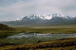
The territory of the coast, high plateau
s and Andean
punas of the Ancash Region are flat, while the rest of the territory, in the Andes, is very rough. In the west, slopes with strong declivity form narrow canyons with abrupt and deserted sides.
The rough territory of the region is crossed by two mountain range
s: on the
western side, it's the Cordillera Negra
(the Black Mountain Range), which has peaks without glacier
s, and on the eastern side, it's the Cordillera Blanca
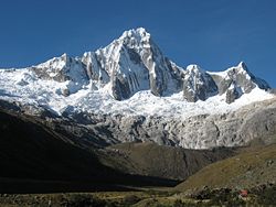
(the White Mountain Range), which has many peaks covered with snow and ice, like the Huascarán
and the Alpamayo
. Between these two mountain ranges, the Santa River
flows through the so-called Callejón de Huaylas. This alley narrows to form the Cañón del Pato
(Duck Canyon). Also along the Pacific slopes, the Santa River has shaped a wide valley in the punas which narrows into the Cordillera Negra where the Cañón del Pato canyon was formed.
The snow-covered peak of Huascarán, highest summit
of Peru and second of the Americas
, reaches a height of 6,768 m (22,205 ft, 4.2 miles) and contrasts with the 6,263 m (20,548 ft) deep trough
of Chimbote found in the ocean west of Ancash. Remnants of glaciers created many lagoons, such as Llanganuco and Paron.
Following the Pan-American highway
north from Lima
, the territory of the region of Ancash begins just beyond the Fortress of Paramonga, between wide fields of sugarcane
, and across the Fortaleza River
, 206 kilometres (128 mi) from Lima.
Along the coast of Ancash, from the Fortaleza River to the Santa River, the Pacific exerts great influence. The Peruvian current
and the El Niño current
exert considerable and sometimes tragic effect on local lives and regional economies.
Normally, the Peruvian current, also known as the Humboldt Current
, brings cold water and lots of fish. With the development of the shoals
of anchoveta
, the Ancash ports and creeks
became commercial fishing centers. During the 1950s, the bay
of Chimbote was the top fishing port of the world.
However, when warmer waters from the north, such as the current of El Niño, bring catastrophic rains to the coast and sea, the shoals
of anchoveta disappear, leaving the fishing fleet
s plants paralyzed; and flooding rivers cause serious damage to the lands and cities. The cycles of these two sea currents that affect Peru are hard to predict.
Further north along the Pan-American highway, numerous islands and islets dot the sea near the coast. Most are home only to guano
seabirds. From south to north, the most important islands include:
The coastal region of Peru includes many peninsula
s, creeks
, warm bays and sand beach
es, full of color. Because of the lack of roads and difficult terrain, many of these are inaccessible by land. The most important beaches include:
Much of this coast is a monotonous stretch of huge sand desert
s, a common denominator in all Peruvian coastal regions because of the influence of the Humboldt Current.
Along the rivers, there are green valleys, cultivated mainly with sugarcane
, rice
and cotton
.
From south to north, the main rivers of the Ancash coast are the following:
Of these rivers, the only one with water year-round is the Santa River; its sources are the Cordillera Blanca's glaciers and lagoons. The other rivers, as with most rivers of the Peruvian coast, are intermittent, depending on the highland rains or the advance of El Niño.
(department of Lima
), where Simón Bolívar planned his Peruvian liberty expedition, is 202 kilometres (126 mi) north of Lima on the Pan-American Highway. At this point begins the highway that leads to the Callejón de Huaylas. This road is completely paved, although it often has to be repaired because of the extreme damage caused by the huayco
s (avalanches) and the rains. The same problem affects most Peruvian roads, especially the ones in the mountains
and rainforest
.
This highway is 287 kilometres (178 mi) long, with an extremely comfortable course, especially in the steep climbing stretches through the Cordillera Negra (Black Range) up to the summit of Conococha
, 4,100 metres (13,451 ft) above sea level. From there, the road begins to go down toward the Callejón de Huaylas.
The trip Lima-Huaraz-Caraz of 468 kilometres (254 mi) can be made in seven hours by car. Modern buses take eight hours in the same stretch.
East of Pativilca, for about 20 kilometres (12 mi) the highway passes between wide fields planted with sugarcane in extensive fields, parallel to the Fortaleza river
bed
.
At Huaricanga
town, the road enters the department of Ancash. At this point, the highway begins a slow ascent of the first spurs
of the Cordillera Negra. This stretch continues for about 50 kilometres (31 mi). The climb gets suddenly steeper beyond the towns of Chasquitambo
and Chaucayán, with many bends and serpentines
.
 This mountain range
is composed by gigantic summits covered with snow, which are among the most beautiful of the world. The White mountain range is considered the highest tropical mountain range in the world. It borders the Callejón de Huaylas
to the east. It has a length of 180 km.
It has 35 peaks
that are higher than 6000 m and many other smaller ones, a real symphony of summits
with different grades of difficulty in climbing.
This mountain range was called White, not only for its eternal snow but also for the chemical constitution of its quartz
and feldspar
rocks. It has the highest summit
in Peru
and the fifth one in America
after Aconcagua
, Ojos del Salado
, Bonete
and Mercedario
: Huascarán
, whose south peak
reaches 6768 msnm. Huascarán
's north peak
reaches 6655 m.
Alpamayo
, which height has been estimated in 5,947 m, has been considered as "the most beautiful snow mountain of the world". This statement was achieved by the distinguished Peru
vian mountaineer
César Morales Arnao, who sent the photo of Alpamayo
to the world contest of scenic beauty made in 1966 in Münich
, Germany
.
North Huandoy
reaches 6395 m, Huantsán reaches 6410 m, Chopicalqui
reaches 6354 m, North Copa reaches 6173 m, Artesonraju
reaches 6025 m, South Santa Cruz reaches 6259 m and Hualcán reaches 6126 m.
The beauty of the Cordillera Blanca
is largely determined by the Cordillera Negra
, because this mountain range
soften the winds that come from the Pacific ocean
. The Cordillera Negra
, acting as a shield, avoids the thaw of the big glacier
s from the Cordillera Blanca
.
The Cordillera Negra
has rocky peaks
with very little winter snowfall, reaching a maximum height of 5500 m. Its name comes from the comparison with the white snowy peaks of the Cordillera Blanca
.
 The Huascarán National Park
is one of the most outstanding conservation parks in Peru
, due to its landscapes that are full of peaks
, lake
s, canyon
s, torrents
and waterfall
s. Inside its borders, it can be observed the whole Cordillera Blanca
and seven peaks
of more than 6000 m height. They constitute one of the main international focuses for climbers and mountaineers
. It was stated as a National Park
on July 1, 1975 with a surface of 340,000 ha and a length of 158 km. This National Park
includes parts of the following provinces: Recuay
, Huaraz
, Carhuaz
, Yungay
, Huaylas
, Pomabamba
, Mariscal Luzuriaga
, Huari
, Corongo
, Sihuas
and Bolognesi
. This park has also been stated as a Biosphere reservation and as a World Heritage Site
by the UNESCO
.
The park territory is very uneven. It has snowy summits
, which altitudes vary between 5000 and 6768 msnm. It also has gullies
, that are deeply encased because of the fluvioglacial erosion
, and a great number of lagoon
s. Inside the borders of the park, there are 663 glacier
s that are distributed throughout 180 km, from the Tuco peak in the south up to Champará in the north.
Regarding its climate
, there are two very well defined season
s:
Its flora
is countless and beautiful, including important groups of Puya Raimondi
. In its fauna
, there are brown brockets
, taruca
s, spectacled bear
s, vicuña
s, pumas, foxes
, vizcachas, weasels
, andean mountain cats, opossums
, hog-nosed skunk
s, etc.
There is also a great number of bird
s, predominating duck
s, american coot
s and hummingbirds
.
-Huaraz
is not a very highly travelled road. The highway begins with a paved path that arrives up to Yaután
. Then it quickly begins to ascend through an unpaved path by the sides of the Cordillera Negra
(Black mountain range), following the course of the Casma River
. This route becomes more steep once it arrives to Pariacoto
. Along the road, there are not important towns at all, except for Pira that offers some traveler's services.
This route, extremely steep and narrow, goes between big abysses and gullies
. It can be seen small rural districts with chacras (smallholding
s) that have been sown with potato
es, wheat
, barley
and other food products. It can also be seen livestock
and a lot of human activity.
The gullies
of the Cordillera Negra
-that goes, simultaneously, with the Cordillera Blanca
throughout 150 km- are gloomy and dark. Most of them are dry or their flow
is scarce. From north to south, there are some hills like Rumicruz (5020 m), Rocarre (5187 m), Cerro Rico (5015 m), and Chonta (4810 m).
The Cordillera Blanca
's beauty is largely determined by the Cordillera Negra
, because this mountain range
soften the winds that come from the Pacific ocean
. The Cordillera Negra
, acts like a shield and avoids the thaw of the big glacier
s that are located in the Cordillera Blanca
.
The Cordillera Negra
has rocky peaks
with very little winter snow
, reaching a maximum height of 5500 m. Its name comes from the comparison with the white snowy peaks of the Cordillera Blanca
.
to Huallanca
, there are approximately 140 km. This unpaved and very little travelled highway is a provisional line over the embankment
of the old railroad. This railway and several tunnels were destroyed by the catastrophe of 1970.
The highway, outside Chimbote
, goes through the wide flat and fertile embankments
of the Santa valley and it continuous its course up to Huallanca
.
From Chuquicara, the highway becomes narrower. The Chuquicara river is a big Santa
's tributary for its right bank. Its waters are black because they contain abundant coal sediments proceeding from the heights of Pallasca.
From Huallanca
, it is possible to travel through the Cañon del Pato
. This canyon is one the many canyons that are along the 370 km of the Santa river
. The Santa river
has its source in the Conococha lagoon. This river is the most important river in the coast, because its annual water mass is 6100 millions of m3. As centuries went by, it has formed a narrow pass of 2000 m of altitude in the Cordillera Negra
.
In this place, the waters turn into whirlpools and rapids before going out from a narrow gorge of 500 m that is called Cañon del Pato
(Duck Cannyon). This water fall constitutes the source of hydroelectric energy in the Power station of the Cañón del Pato
, in Huallanca
.
From Huallanca
, it is possible to enter to the Callejon de Huaylas
by the highway that takes to Caraz
. It is also a way to enter to the callejon de Conchucos
(Conchucos alley).
. It is connected by a highway that goes from Catac
to Huallanca
.
There are eight provinces of the Ancash Region that cover the Callejon de Conchucos. They are Huari
, Asunción
, Antonio Raimondi, Mariscal Luzuriaga
, Pomabamba
, Sihuas
, Corongo
and Pallasca
. This Callejón is located to the east of the Cordillera Blanca
, that is to say, to the other side of the Callejon of Huaylas
, before the Marañon river
.
The topography
of the soil presents high summits
, deep valley
s and inhospitable punas, making it a rough zone, such as most of the highland
in Peru
.
The northern provinces of Pallasca
and Corongo
have their own direct access towards Chimbote
and the Callejon of Huaylas. The other provinces have a longitudinal highway of double entry, one from Huari
and the other one from Huallanca
and Sihuas
, joining Pomabamba
, Luzuriaga
and Raimondi.
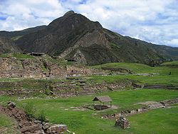 Between the years 400 and 600 BC, the first Peruvian civilization, known as Chavín
, originated and flourished in this zone. The importance of this culture lies not only in its antiquity but in the history and culture it shares with other cultures along the Andean
and Amazonian
territories. As archaeologist Julio C. Tello
put it, "Chavín was the mother of all the cultures that later bloomed in the old Peru
." The name Chavín comes from the Quechua word Chaupin, which translates as center or headquarters. Tello believed that people came from the Amazonas
, scaled the Andes, and developed the Chavín culture.
During the Inca age, the population of the Santa valley was assimilated into the Inca empire by Pachacuti.
The first Spaniards
came to Huaylas attracted by the fame of the silver veins
of the region. In time, the Spanish destroyed the Inca cities. It was during this time that Jeronimo de Alvarado founded the city of Huaraz. Though in the Colonial Age
this city held little importance and its artistic and cultural life did not have much relevance, it became the headquarters for Simón Bolívar
during his campaign to liberate Peru.
The 1970 Ancash earthquake
devastated the region, killing more than 50,000 people and damaging 186,000 houses in one of the deadliest natural disasters in Peru.
Today, most of the Ancash population is concentrated in the Callejón de Huaylas
.
). Crops cultivated in Ancash include potatoes, wheat and barley.
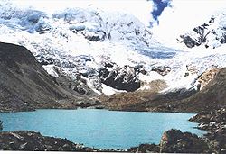 Ancash's geographical center, the Callejón de Huaylas, is an area of intense interest to tourists. This is due to its large variety of natural attractions, its sport and recreational facilities, and the nearby archaeological remains of the ancient cultures that once flourished there. The Cordillera Blanca, the highest peak in the Peruvian Andes, offers an interesting attraction for tourists visiting Peru. Visitors also come to see the natural beauty of the area's glaciers and valleys and to enjoy the many lagoon
s and thermal fountains.
Ancash is sometimes referred to as the "Switzerland
of Peru." There is the four mile high Huascarán, home to the Huascarán National Park
. There is also the Alpamayo peak, considered one of the most beautiful in the world.
Among archaeological sites of interest, Ancash has many vestiges of old cultures, including the Guitarrero Cave (10,000 BC), the pre-Columbian
ruins of Chavín de Huántar
. Hunsakay, Willkawain, Sechín, and Pañamarca are also well-known.
In addition, the region has a network of local roads.
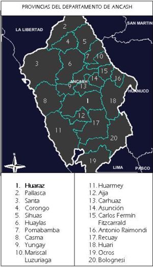 The region is divided into 20 province
s (provincias, singular: provincia), which comprise 166 district
s (distritos, singular: distrito). Its capital is Huaraz.
The provinces and their capitals are:
Peru
Peru , officially the Republic of Peru , is a country in western South America. It is bordered on the north by Ecuador and Colombia, on the east by Brazil, on the southeast by Bolivia, on the south by Chile, and on the west by the Pacific Ocean....
. It is bordered by the La Libertad region
La Libertad Region
La Libertad is a region in northwestern Peru. Formerly it was known as the 'Department of La Libertad" , a political division that generally corresponds to a state in the United States of America...
on the north, the Huánuco
Huánuco Region
Huánuco is a region in central Peru. It is bordered by the La Libertad, San Martín, Loreto and Ucayali regions on the north; the Ucayali Region on the east; the Pasco Region on the south; and the Lima and Ancash regions on the west. Its capital is the city of Huánuco.Huánuco has a rough topography...
and Pasco
Pasco Region
Pasco is a region in central Peru. Its capital is Cerro de Pasco.-Political division:The region is divided into 3 provinces , which are composed of 28 districts .-Provinces:...
regions on the east, the Lima
Lima Region
Lima Region, also known as Lima Provincias, is one of twenty-five regions of Peru. Located in the central coast of the country, its regional seat is Huacho....
region on the south, and the Pacific Ocean
Pacific Ocean
The Pacific Ocean is the largest of the Earth's oceanic divisions. It extends from the Arctic in the north to the Southern Ocean in the south, bounded by Asia and Australia in the west, and the Americas in the east.At 165.2 million square kilometres in area, this largest division of the World...
on the west. Its capital is the city of Huaraz
Huaraz
Huaraz is a city in Peru. It is the capital of the Departmento de Ancash and the seat of government of the Provincia de Huaraz . The urban agglomerations population is distributed over the districts of Huaraz and Independencia. It was estimated in 2007 to exceed 120,000...
, and its largest city and port is Chimbote
Chimbote
Chimbote is the largest city in the Ancash Region of Peru, and the capital of both Santa Province and Chimbote District.The city is located on the coast in Chimbote Bay, south of Trujillo and north of Lima on the North Pan-American highway. It is the start of a chain of important cities like...
. The name of the region originates from the Quechua word anqash, which means blue
Blue
Blue is a colour, the perception of which is evoked by light having a spectrum dominated by energy with a wavelength of roughly 440–490 nm. It is considered one of the additive primary colours. On the HSV Colour Wheel, the complement of blue is yellow; that is, a colour corresponding to an equal...
.
Geography
Valley
In geology, a valley or dale is a depression with predominant extent in one direction. A very deep river valley may be called a canyon or gorge.The terms U-shaped and V-shaped are descriptive terms of geography to characterize the form of valleys...
s, which combine the mountain characteristics of the Callejón de Huaylas (Alley of Huaylas) with the sylvan ones of the Alto Marañón
Alto Marañón
Alto Marañón is a region in Peru with an area of more than 30,000 square kilometres. It is located within the northeastern region of the Marañón. The region has five significant rivers and a population in excess of 40,000 people. The population is distributed across 240 communities of mainly...
. Miles of sandy beaches abut the blue waters of the Pacific.
The territory of the coast, high plateau
Plateau
In geology and earth science, a plateau , also called a high plain or tableland, is an area of highland, usually consisting of relatively flat terrain. A highly eroded plateau is called a dissected plateau...
s and Andean
Andes
The Andes is the world's longest continental mountain range. It is a continual range of highlands along the western coast of South America. This range is about long, about to wide , and of an average height of about .Along its length, the Andes is split into several ranges, which are separated...
punas of the Ancash Region are flat, while the rest of the territory, in the Andes, is very rough. In the west, slopes with strong declivity form narrow canyons with abrupt and deserted sides.
The rough territory of the region is crossed by two mountain range
Mountain range
A mountain range is a single, large mass consisting of a succession of mountains or narrowly spaced mountain ridges, with or without peaks, closely related in position, direction, formation, and age; a component part of a mountain system or of a mountain chain...
s: on the
western side, it's the Cordillera Negra
Cordillera Negra
The Cordillera Negra is part of the Cordillera Oriental, one of three mountain ranges in the Andes Mountains of west central Peru.-Size:...
(the Black Mountain Range), which has peaks without glacier
Glacier
A glacier is a large persistent body of ice that forms where the accumulation of snow exceeds its ablation over many years, often centuries. At least 0.1 km² in area and 50 m thick, but often much larger, a glacier slowly deforms and flows due to stresses induced by its weight...
s, and on the eastern side, it's the Cordillera Blanca
Cordillera Blanca
The Cordillera Blanca is a mountain range in the Ancash Region of Peru. Part of the larger Andes range, it includes 33 major peaks over high in an area wide and long.-Overview:...
(the White Mountain Range), which has many peaks covered with snow and ice, like the Huascarán
Huascarán
Huascarán or Nevado Huascarán is a mountain in the Peruvian province of Yungay, situated in the Cordillera Blanca range of the Western Andes. The highest southern summit of Huascarán is the highest point in Peru, and all the Earth's Tropics...
and the Alpamayo
Alpamayo
Alpamayo is one of the most conspicuous peaks in the Cordillera Blanca mountain range of the Peruvian Andes.It is a steep , almost perfect pyramid of ice, one of a number of peaks that compose the Santa Cruz massif, the northernmost massif of the Cordillera Blanca...
. Between these two mountain ranges, the Santa River
Santa River
The Santa River is a river in the South American Andes cordillera in the Ancash Region of northwest central Peru.-River Course:Laguna Conococha, at an altitude of 4050 m above sea level and at , is considered the headwaters of the Rio Santa. Laguna Conococha itself is fed by small streams from the...
flows through the so-called Callejón de Huaylas. This alley narrows to form the Cañón del Pato
Cañón del Pato
Cañón del Pato is on the Rio Santa at the north end of the Callejón de Huaylas in north-central Peru. The mostly rocky canyon walls are too steep and arid for cultivation, and in only a few places are the slopes of the imposingly rugged canyon suitable even for grazing domestic animals...
(Duck Canyon). Also along the Pacific slopes, the Santa River has shaped a wide valley in the punas which narrows into the Cordillera Negra where the Cañón del Pato canyon was formed.
The snow-covered peak of Huascarán, highest summit
Summit (topography)
In topography, a summit is a point on a surface that is higher in elevation than all points immediately adjacent to it. Mathematically, a summit is a local maximum in elevation...
of Peru and second of the Americas
Americas
The Americas, or America , are lands in the Western hemisphere, also known as the New World. In English, the plural form the Americas is often used to refer to the landmasses of North America and South America with their associated islands and regions, while the singular form America is primarily...
, reaches a height of 6,768 m (22,205 ft, 4.2 miles) and contrasts with the 6,263 m (20,548 ft) deep trough
Trough (geology)
In geology, a trough generally refers to a linear structural depression that extends laterally over a distance, while being less steep than a trench.A trough can be a narrow basin or a geologic rift....
of Chimbote found in the ocean west of Ancash. Remnants of glaciers created many lagoons, such as Llanganuco and Paron.
Following the Pan-American highway
Pan-American Highway
The Pan-American Highway is a network of roads measuring about in total length. Except for an rainforest break, called the Darién Gap, the road links the mainland nations of the Americas in a connected highway system. According to Guinness World Records, the Pan-American Highway is the world's...
north from Lima
Lima
Lima is the capital and the largest city of Peru. It is located in the valleys of the Chillón, Rímac and Lurín rivers, in the central part of the country, on a desert coast overlooking the Pacific Ocean. Together with the seaport of Callao, it forms a contiguous urban area known as the Lima...
, the territory of the region of Ancash begins just beyond the Fortress of Paramonga, between wide fields of sugarcane
Sugarcane
Sugarcane refers to any of six to 37 species of tall perennial grasses of the genus Saccharum . Native to the warm temperate to tropical regions of South Asia, they have stout, jointed, fibrous stalks that are rich in sugar, and measure two to six metres tall...
, and across the Fortaleza River
Fortaleza River
The Fortaleza River is a river of Paraná state in southern Brazil.-References:*...
, 206 kilometres (128 mi) from Lima.
Along the coast of Ancash, from the Fortaleza River to the Santa River, the Pacific exerts great influence. The Peruvian current
Humboldt Current
The Humboldt Current , also known as the Peru Current, is a cold, low-salinity ocean current that flows north-westward along the west coast of South America from the southern tip of Chile to northern Peru. It is an eastern boundary current flowing in the direction of the equator, and can extend...
and the El Niño current
El Niño-Southern Oscillation
El Niño/La Niña-Southern Oscillation, or ENSO, is a quasiperiodic climate pattern that occurs across the tropical Pacific Ocean roughly every five years...
exert considerable and sometimes tragic effect on local lives and regional economies.
Normally, the Peruvian current, also known as the Humboldt Current
Humboldt Current
The Humboldt Current , also known as the Peru Current, is a cold, low-salinity ocean current that flows north-westward along the west coast of South America from the southern tip of Chile to northern Peru. It is an eastern boundary current flowing in the direction of the equator, and can extend...
, brings cold water and lots of fish. With the development of the shoals
Swarm
Swarm behaviour, or swarming, is a collective behaviour exhibited by animals of similar size which aggregate together, perhaps milling about the same spot or perhaps moving en masse or migrating in some direction. As a term, swarming is applied particularly to insects, but can also be applied to...
of anchoveta
Peruvian anchoveta
The Peruvian anchoveta is a fish of the anchovy family, Engraulidae.Anchoveta are pelagic fish in the southeastern Pacific Ocean, and are regularly caught on the coasts of Peru, and Chile. They live for up to 4 years, reaching 20 cm, with recruitment occurring after only about 6 months when...
, the Ancash ports and creeks
Creek (tidal)
A tidal creek, tidal channel, or estuary is the portion of a stream that is affected by ebb and flow of ocean tides, in the case that the subject stream discharges to an ocean, sea or strait. Thus this portion of the stream has variable salinity and electrical conductivity over the tidal cycle...
became commercial fishing centers. During the 1950s, the bay
Headlands and bays
Headlands and bays are two related features of the coastal environment.- Geology and geography :Headlands and bays are often found on the same coastline. A bay is surrounded by land on three sides, whereas a headland is surrounded by water on three sides. Headlands are characterized by high,...
of Chimbote was the top fishing port of the world.
However, when warmer waters from the north, such as the current of El Niño, bring catastrophic rains to the coast and sea, the shoals
Swarm
Swarm behaviour, or swarming, is a collective behaviour exhibited by animals of similar size which aggregate together, perhaps milling about the same spot or perhaps moving en masse or migrating in some direction. As a term, swarming is applied particularly to insects, but can also be applied to...
of anchoveta disappear, leaving the fishing fleet
Fishing fleet
A fishing fleet is an aggregate of commercial fishing vessels. The term may be used of all vessels operating out of a particular port, all vessels engaged in a particular type of fishing , or all fishing vessels of a country or region.Although fishing vessels are not formally organized as if they...
s plants paralyzed; and flooding rivers cause serious damage to the lands and cities. The cycles of these two sea currents that affect Peru are hard to predict.
Further north along the Pan-American highway, numerous islands and islets dot the sea near the coast. Most are home only to guano
Guano
Guano is the excrement of seabirds, cave dwelling bats, and seals. Guano manure is an effective fertilizer due to its high levels of phosphorus and nitrogen and also its lack of odor. It was an important source of nitrates for gunpowder...
seabirds. From south to north, the most important islands include:
- Tortuga Island (Turtle Island)
- La Viuda IslandLa Viuda IslandLa Viuda Island is an island of Peru.The island received its name "The Widow" after the frigate Mercedes sank off the island's shores in 1852, drowning 1,200, including a the boat captain, whose wife survived the tragedy....
(The Widow Island) - Blanca IslandBlanca IslandBlanca Island is a Peruvian island located at 09°06'18.0 south and 78°37'18.0 west. It has an area of approximately 3200 m long and 920 m wide. Its maximum height measures 204 m. Its relief is very rough, rocky. The contours are very deep, especially in the west of the island...
(White Island) - Santa Island (Holy Island)
The coastal region of Peru includes many peninsula
Peninsula
A peninsula is a piece of land that is bordered by water on three sides but connected to mainland. In many Germanic and Celtic languages and also in Baltic, Slavic and Hungarian, peninsulas are called "half-islands"....
s, creeks
Creek (tidal)
A tidal creek, tidal channel, or estuary is the portion of a stream that is affected by ebb and flow of ocean tides, in the case that the subject stream discharges to an ocean, sea or strait. Thus this portion of the stream has variable salinity and electrical conductivity over the tidal cycle...
, warm bays and sand beach
Beach
A beach is a geological landform along the shoreline of an ocean, sea, lake or river. It usually consists of loose particles which are often composed of rock, such as sand, gravel, shingle, pebbles or cobblestones...
es, full of color. Because of the lack of roads and difficult terrain, many of these are inaccessible by land. The most important beaches include:
- Grande Beach
- La Gramita Beach
- Las Salinas Beach
Much of this coast is a monotonous stretch of huge sand desert
Desert
A desert is a landscape or region that receives an extremely low amount of precipitation, less than enough to support growth of most plants. Most deserts have an average annual precipitation of less than...
s, a common denominator in all Peruvian coastal regions because of the influence of the Humboldt Current.
Along the rivers, there are green valleys, cultivated mainly with sugarcane
Sugarcane
Sugarcane refers to any of six to 37 species of tall perennial grasses of the genus Saccharum . Native to the warm temperate to tropical regions of South Asia, they have stout, jointed, fibrous stalks that are rich in sugar, and measure two to six metres tall...
, rice
Rice
Rice is the seed of the monocot plants Oryza sativa or Oryza glaberrima . As a cereal grain, it is the most important staple food for a large part of the world's human population, especially in East Asia, Southeast Asia, South Asia, the Middle East, and the West Indies...
and cotton
Gossypium barbadense
Gossypium barbadense, also known as extra long staple cotton as it generally has a staple of at least 1 3/8" or longer, is a species of cotton plant. Some types of ELS cotton are American Pima, Egyptian Giza, Indian Suvin, Chinese Xiniang, Sudanese Barakat, and Russian Tonkovoloknistyi...
.
From south to north, the main rivers of the Ancash coast are the following:
- Huarmey RiverHuarmey RiverThe Huarmey River in Peru is a seasonal river, with flows in the months of December to March; along with the underground water it is a vital source for the agricultural activities, industrial and domestic in the region....
- Culebras River
- Casma RiverCasma RiverThe Casma is a river that crosses northern Casma province in the Ancash Region of Peru. It originates in the Black Mountain Range and drains into the Pacific Ocean.Major tributaries include the Sechín River and the Grande River ....
- Sechín RiverSechín RiverSechín River in Peru, Ancash Region remains dry for long seasons, increasing its volume at times of rain in the mountain range. It is of irregular regime, due to this is known as Loco River. It rises at an altitude of 4385 m.s.n.m. in Cordillera Negra and it ends at the Casma River....
- Nepeña River
- Lacramarca RiverLacramarca RiverLacramarca River is a river that flows through the Santa Province of Peru....
- Santa River
Of these rivers, the only one with water year-round is the Santa River; its sources are the Cordillera Blanca's glaciers and lagoons. The other rivers, as with most rivers of the Peruvian coast, are intermittent, depending on the highland rains or the advance of El Niño.
Pativilca-Caraz-Huallanca Route
The historical village of PativilcaPativilca
Pativilca is a town in central Peru, capital of the district Pativilca in the province Barranca in the region Lima.-External links:...
(department of Lima
Lima Region
Lima Region, also known as Lima Provincias, is one of twenty-five regions of Peru. Located in the central coast of the country, its regional seat is Huacho....
), where Simón Bolívar planned his Peruvian liberty expedition, is 202 kilometres (126 mi) north of Lima on the Pan-American Highway. At this point begins the highway that leads to the Callejón de Huaylas. This road is completely paved, although it often has to be repaired because of the extreme damage caused by the huayco
Huayco
A huayco or huaico is a Peruvian term that refers to a flash flood caused by torrential rains occurring high in the mountains, especially during the weather known as El Niño....
s (avalanches) and the rains. The same problem affects most Peruvian roads, especially the ones in the mountains
Quechua (Geography)
Quechua is one of the eight Natural Regions of Peru and is between 2,300 and 3,500 m above sea level. It is composed of big valleys divided by rivers fed by estival rains.Its flora includes Andean alder, gongapa, and arracacha...
and rainforest
Rupa-Rupa
Rupa-Rupa or High Jungle is one of the eight natural regions of Peru. It is located between 400 and 1,000 m above the sea level. This region has lots of narrow and long valleys and fluvial mountain trails...
.
This highway is 287 kilometres (178 mi) long, with an extremely comfortable course, especially in the steep climbing stretches through the Cordillera Negra (Black Range) up to the summit of Conococha
Laguna Conococha
Laguna Conococha is a lake in the Andes-Cordillera of South America in north-western Peru.Laguna Conococha is situated in the Ancash Region at an altitude of 4,050 m above sea level and at on the road from Callejón de Huaylas to Chiquián.The lake is seen as the headwaters of Río Santa which from...
, 4,100 metres (13,451 ft) above sea level. From there, the road begins to go down toward the Callejón de Huaylas.
The trip Lima-Huaraz-Caraz of 468 kilometres (254 mi) can be made in seven hours by car. Modern buses take eight hours in the same stretch.
East of Pativilca, for about 20 kilometres (12 mi) the highway passes between wide fields planted with sugarcane in extensive fields, parallel to the Fortaleza river
Fortaleza River
The Fortaleza River is a river of Paraná state in southern Brazil.-References:*...
bed
Stream bed
A stream bed is the channel bottom of a stream, river or creek; the physical confine of the normal water flow. The lateral confines or channel margins, during all but flood stage, are known as the stream banks or river banks. In fact, a flood occurs when a stream overflows its banks and flows onto...
.
At Huaricanga
Huaricanga
Huaricanga is the earliest city of the Norte Chico civilization. It existed around 3500 BCE and was the oldest city in the Americas and one of the earliest cities in the world."-References:...
town, the road enters the department of Ancash. At this point, the highway begins a slow ascent of the first spurs
Spur (mountain)
A spur is a subsidiary summit of a hill or mountain. By definition, spurs have low topographic prominence, as they are lower than their parent summit and are closely connected to them on the same ridgeline...
of the Cordillera Negra. This stretch continues for about 50 kilometres (31 mi). The climb gets suddenly steeper beyond the towns of Chasquitambo
Chasquitambo
Chasquitambo is a location in the Peruvian district of Colquioc, Bolognesi Province, located in the Department of Ancash, belonging to the Region Ancash....
and Chaucayán, with many bends and serpentines
Serpentine shape
Serpentine refers to the curved shape of an object or design which resembles the letter s, a sine wave or a snake; the latter is the derivation of the term.- Examples :* The Serpentine River...
.
The White Mountain Range
Mountain range
A mountain range is a single, large mass consisting of a succession of mountains or narrowly spaced mountain ridges, with or without peaks, closely related in position, direction, formation, and age; a component part of a mountain system or of a mountain chain...
is composed by gigantic summits covered with snow, which are among the most beautiful of the world. The White mountain range is considered the highest tropical mountain range in the world. It borders the Callejón de Huaylas
Callejón de Huaylas
The Santa Valley is a inter-andean valley in the Ancash Region in the north-central highlands of Peru. Due to its location between two mountain ranges it is known as Callejón de Huaylas —Alley of Huaylas—, whereas Huaylas refers to the name of the territorial division's name during the Viceroyalty...
to the east. It has a length of 180 km.
It has 35 peaks
Summit (topography)
In topography, a summit is a point on a surface that is higher in elevation than all points immediately adjacent to it. Mathematically, a summit is a local maximum in elevation...
that are higher than 6000 m and many other smaller ones, a real symphony of summits
Summit (topography)
In topography, a summit is a point on a surface that is higher in elevation than all points immediately adjacent to it. Mathematically, a summit is a local maximum in elevation...
with different grades of difficulty in climbing.
This mountain range was called White, not only for its eternal snow but also for the chemical constitution of its quartz
Quartz
Quartz is the second-most-abundant mineral in the Earth's continental crust, after feldspar. It is made up of a continuous framework of SiO4 silicon–oxygen tetrahedra, with each oxygen being shared between two tetrahedra, giving an overall formula SiO2. There are many different varieties of quartz,...
and feldspar
Feldspar
Feldspars are a group of rock-forming tectosilicate minerals which make up as much as 60% of the Earth's crust....
rocks. It has the highest summit
Summit (topography)
In topography, a summit is a point on a surface that is higher in elevation than all points immediately adjacent to it. Mathematically, a summit is a local maximum in elevation...
in Peru
Peru
Peru , officially the Republic of Peru , is a country in western South America. It is bordered on the north by Ecuador and Colombia, on the east by Brazil, on the southeast by Bolivia, on the south by Chile, and on the west by the Pacific Ocean....
and the fifth one in America
Americas
The Americas, or America , are lands in the Western hemisphere, also known as the New World. In English, the plural form the Americas is often used to refer to the landmasses of North America and South America with their associated islands and regions, while the singular form America is primarily...
after Aconcagua
Aconcagua
Aconcagua is the highest mountain in the Americas at . It is located in the Andes mountain range, in the Argentine province of Mendoza and it lies west by north of its capital, the city of Mendoza. The summit is also located about 5 kilometres from San Juan Province and 15 kilometres from the...
, Ojos del Salado
Ojos del Salado
Nevado Ojos del Salado is a massive stratovolcano in the Andes on the Argentina-Chile border and the highest volcano in the world at . It is also the second highest mountain in the Western Hemisphere and Southern Hemisphere and the highest in Chile...
, Bonete
Bonete
Cerro Bonete is a mountain in the north of the province of La Rioja, Argentina, near the provincial border with Catamarca. Its summit is 6,759 m above mean sea level, making it the fourth highest separate mountain in the Americas . SRTM data disproves the frequently made claim that its summit is...
and Mercedario
Mercedario
Cerro Mercedario is the highest peak of the Cordillera de la Ramada range and the eighth highest mountain of the Andes. It is located 100 km to the north of Aconcagua, in the Argentine province of San Juan...
: Huascarán
Huascarán
Huascarán or Nevado Huascarán is a mountain in the Peruvian province of Yungay, situated in the Cordillera Blanca range of the Western Andes. The highest southern summit of Huascarán is the highest point in Peru, and all the Earth's Tropics...
, whose south peak
Summit (topography)
In topography, a summit is a point on a surface that is higher in elevation than all points immediately adjacent to it. Mathematically, a summit is a local maximum in elevation...
reaches 6768 msnm. Huascarán
Huascarán
Huascarán or Nevado Huascarán is a mountain in the Peruvian province of Yungay, situated in the Cordillera Blanca range of the Western Andes. The highest southern summit of Huascarán is the highest point in Peru, and all the Earth's Tropics...
's north peak
Summit (topography)
In topography, a summit is a point on a surface that is higher in elevation than all points immediately adjacent to it. Mathematically, a summit is a local maximum in elevation...
reaches 6655 m.
Alpamayo
Alpamayo
Alpamayo is one of the most conspicuous peaks in the Cordillera Blanca mountain range of the Peruvian Andes.It is a steep , almost perfect pyramid of ice, one of a number of peaks that compose the Santa Cruz massif, the northernmost massif of the Cordillera Blanca...
, which height has been estimated in 5,947 m, has been considered as "the most beautiful snow mountain of the world". This statement was achieved by the distinguished Peru
Peru
Peru , officially the Republic of Peru , is a country in western South America. It is bordered on the north by Ecuador and Colombia, on the east by Brazil, on the southeast by Bolivia, on the south by Chile, and on the west by the Pacific Ocean....
vian mountaineer
Mountaineering
Mountaineering or mountain climbing is the sport, hobby or profession of hiking, skiing, and climbing mountains. While mountaineering began as attempts to reach the highest point of unclimbed mountains it has branched into specialisations that address different aspects of the mountain and consists...
César Morales Arnao, who sent the photo of Alpamayo
Alpamayo
Alpamayo is one of the most conspicuous peaks in the Cordillera Blanca mountain range of the Peruvian Andes.It is a steep , almost perfect pyramid of ice, one of a number of peaks that compose the Santa Cruz massif, the northernmost massif of the Cordillera Blanca...
to the world contest of scenic beauty made in 1966 in Münich
Munich
Munich The city's motto is "" . Before 2006, it was "Weltstadt mit Herz" . Its native name, , is derived from the Old High German Munichen, meaning "by the monks' place". The city's name derives from the monks of the Benedictine order who founded the city; hence the monk depicted on the city's coat...
, Germany
Germany
Germany , officially the Federal Republic of Germany , is a federal parliamentary republic in Europe. The country consists of 16 states while the capital and largest city is Berlin. Germany covers an area of 357,021 km2 and has a largely temperate seasonal climate...
.
North Huandoy
Huandoy
Huandoy is the second-tallest peak of the Cordillera Blanca section of the Andes, after Nevado Huascarán. These two peaks are rather nearby, separated only by the Llanganuco ravine with its Lagunas Llanganuco ....
reaches 6395 m, Huantsán reaches 6410 m, Chopicalqui
Chopicalqui
Chopicalqui is a mountain in the Cordillera Blanca in the Andes of Peru. With a summit altitude of 6,354 meters above sea level, it is one of the Cordillera Blanca's highest peaks....
reaches 6354 m, North Copa reaches 6173 m, Artesonraju
Artesonraju
Artesonraju is a peak in the Cordillera Blanca mountain range, a part of the Peruvian Andes, is also known as Arteson. To reach the lake there is a dirt road from Caraz which climbs +2000m along 32km in about 1:40 hours. At Pueblo Paron there's a check point and a gate, where visitors must pay...
reaches 6025 m, South Santa Cruz reaches 6259 m and Hualcán reaches 6126 m.
The beauty of the Cordillera Blanca
Cordillera Blanca
The Cordillera Blanca is a mountain range in the Ancash Region of Peru. Part of the larger Andes range, it includes 33 major peaks over high in an area wide and long.-Overview:...
is largely determined by the Cordillera Negra
Cordillera Negra
The Cordillera Negra is part of the Cordillera Oriental, one of three mountain ranges in the Andes Mountains of west central Peru.-Size:...
, because this mountain range
Mountain range
A mountain range is a single, large mass consisting of a succession of mountains or narrowly spaced mountain ridges, with or without peaks, closely related in position, direction, formation, and age; a component part of a mountain system or of a mountain chain...
soften the winds that come from the Pacific ocean
Pacific Ocean
The Pacific Ocean is the largest of the Earth's oceanic divisions. It extends from the Arctic in the north to the Southern Ocean in the south, bounded by Asia and Australia in the west, and the Americas in the east.At 165.2 million square kilometres in area, this largest division of the World...
. The Cordillera Negra
Cordillera Negra
The Cordillera Negra is part of the Cordillera Oriental, one of three mountain ranges in the Andes Mountains of west central Peru.-Size:...
, acting as a shield, avoids the thaw of the big glacier
Glacier
A glacier is a large persistent body of ice that forms where the accumulation of snow exceeds its ablation over many years, often centuries. At least 0.1 km² in area and 50 m thick, but often much larger, a glacier slowly deforms and flows due to stresses induced by its weight...
s from the Cordillera Blanca
Cordillera Blanca
The Cordillera Blanca is a mountain range in the Ancash Region of Peru. Part of the larger Andes range, it includes 33 major peaks over high in an area wide and long.-Overview:...
.
The Cordillera Negra
Cordillera Negra
The Cordillera Negra is part of the Cordillera Oriental, one of three mountain ranges in the Andes Mountains of west central Peru.-Size:...
has rocky peaks
Summit (topography)
In topography, a summit is a point on a surface that is higher in elevation than all points immediately adjacent to it. Mathematically, a summit is a local maximum in elevation...
with very little winter snowfall, reaching a maximum height of 5500 m. Its name comes from the comparison with the white snowy peaks of the Cordillera Blanca
Cordillera Blanca
The Cordillera Blanca is a mountain range in the Ancash Region of Peru. Part of the larger Andes range, it includes 33 major peaks over high in an area wide and long.-Overview:...
.
Huascarán National Park
Huascarán National Park
Huascarán National Park is a national park in the Cordillera Blanca, a range of the Andes, in Ancash of central Peru. It was also pronounced as Natural Heritage of Humanity and recognized as Reserve of Biosphere Core. The highest mountain in Peru is located in the park...
is one of the most outstanding conservation parks in Peru
Peru
Peru , officially the Republic of Peru , is a country in western South America. It is bordered on the north by Ecuador and Colombia, on the east by Brazil, on the southeast by Bolivia, on the south by Chile, and on the west by the Pacific Ocean....
, due to its landscapes that are full of peaks
Summit (topography)
In topography, a summit is a point on a surface that is higher in elevation than all points immediately adjacent to it. Mathematically, a summit is a local maximum in elevation...
, lake
Lake
A lake is a body of relatively still fresh or salt water of considerable size, localized in a basin, that is surrounded by land. Lakes are inland and not part of the ocean and therefore are distinct from lagoons, and are larger and deeper than ponds. Lakes can be contrasted with rivers or streams,...
s, canyon
Canyon
A canyon or gorge is a deep ravine between cliffs often carved from the landscape by a river. Rivers have a natural tendency to reach a baseline elevation, which is the same elevation as the body of water it will eventually drain into. This forms a canyon. Most canyons were formed by a process of...
s, torrents
Stream
A stream is a body of water with a current, confined within a bed and stream banks. Depending on its locale or certain characteristics, a stream may be referred to as a branch, brook, beck, burn, creek, "crick", gill , kill, lick, rill, river, syke, bayou, rivulet, streamage, wash, run or...
and waterfall
Waterfall
A waterfall is a place where flowing water rapidly drops in elevation as it flows over a steep region or a cliff.-Formation:Waterfalls are commonly formed when a river is young. At these times the channel is often narrow and deep. When the river courses over resistant bedrock, erosion happens...
s. Inside its borders, it can be observed the whole Cordillera Blanca
Cordillera Blanca
The Cordillera Blanca is a mountain range in the Ancash Region of Peru. Part of the larger Andes range, it includes 33 major peaks over high in an area wide and long.-Overview:...
and seven peaks
Summit (topography)
In topography, a summit is a point on a surface that is higher in elevation than all points immediately adjacent to it. Mathematically, a summit is a local maximum in elevation...
of more than 6000 m height. They constitute one of the main international focuses for climbers and mountaineers
Mountaineering
Mountaineering or mountain climbing is the sport, hobby or profession of hiking, skiing, and climbing mountains. While mountaineering began as attempts to reach the highest point of unclimbed mountains it has branched into specialisations that address different aspects of the mountain and consists...
. It was stated as a National Park
National park
A national park is a reserve of natural, semi-natural, or developed land that a sovereign state declares or owns. Although individual nations designate their own national parks differently A national park is a reserve of natural, semi-natural, or developed land that a sovereign state declares or...
on July 1, 1975 with a surface of 340,000 ha and a length of 158 km. This National Park
National park
A national park is a reserve of natural, semi-natural, or developed land that a sovereign state declares or owns. Although individual nations designate their own national parks differently A national park is a reserve of natural, semi-natural, or developed land that a sovereign state declares or...
includes parts of the following provinces: Recuay
Recuay Province
-Political division:Recuay is divided into ten districts, which are:...
, Huaraz
Huaraz Province
The Huaraz Province is one of twenty provinces of the Ancash Region in Peru. It was created on August 5, 1857 during the presidency of Ramón Castilla. Geographically, the province is located over the Callejón de Huaylas and the western slopes of the Cordillera Negra.The Regional Museum of...
, Carhuaz
Carhuaz Province
-Political division:Carhuaz is divided into eleven districts, which are:-External links:...
, Yungay
Yungay Province
-Political division:Yungay is divided into eight districts, which are:-External links:...
, Huaylas
Huaylas Province
-Political division:Huaylas is divided into ten districts, which are:-External links:...
, Pomabamba
Pomabamba Province
The Pomabamba Province is one of twenty provinces of the Ancash Region in Peru. It was formerly called pumapampa - the lion's plain - and today it is also known as "The City of Cedars". It is located at the left bank of the Pomabamba river, at above sea level...
, Mariscal Luzuriaga
Mariscal Luzuriaga Province
The Mariscal Luzuriaga Province is one of 20 provinces of the Ancash Region in Peru. It was created by law 12541 on January 12, 1956. Since the Inca roads crossed its territory up to the Ecuador, where its capital Piscobamba is located now, there was a strategic tambo during the Inca's...
, Huari
Huari Province
The Huari Province is one of twenty provinces of the Ancash Region in Peru. The famous Chavín de Huantar archaeological site is located in this province.-Political division:Huari is divided into sixteen districts, which are:-External links:...
, Corongo
Corongo Province
The Corongo Province is one of 20 provinces of the Ancash Region in Peru. Its capital is Corongo located at an altitude of 3,141 m ....
, Sihuas
Sihuas Province
The Sihuas Province is one of twenty provinces of the Ancash Region in Peru. It is bordered by provinces of Huaylas and Corongo on the west, Pallasca Province on the north, La Libertad Region on the east, and Pomabamba Province on the south....
and Bolognesi
Bolognesi Province
The Bolognesi Province is one of 20 provinces of the Ancash Region of Peru.-Political division:Bolognesi is divided into fifteen districts, which are:...
. This park has also been stated as a Biosphere reservation and as a World Heritage Site
World Heritage Site
A UNESCO World Heritage Site is a place that is listed by the UNESCO as of special cultural or physical significance...
by the UNESCO
UNESCO
The United Nations Educational, Scientific and Cultural Organization is a specialized agency of the United Nations...
.
The park territory is very uneven. It has snowy summits
Summit (topography)
In topography, a summit is a point on a surface that is higher in elevation than all points immediately adjacent to it. Mathematically, a summit is a local maximum in elevation...
, which altitudes vary between 5000 and 6768 msnm. It also has gullies
Gully
A gully is a landform created by running water, eroding sharply into soil, typically on a hillside. Gullies resemble large ditches or small valleys, but are metres to tens of metres in depth and width...
, that are deeply encased because of the fluvioglacial erosion
Fluvioglacial landform
Fluvioglacial landforms are landforms molded by glacial meltwater. This discharge of glacial streams, both over the surface and beneath the ice sheet , is higher in the warmer summer months. As subglacial water often flows under pressure, it has a high velocity and is very turbulent...
, and a great number of lagoon
Lagoon
A lagoon is a body of shallow sea water or brackish water separated from the sea by some form of barrier. The EU's habitat directive defines lagoons as "expanses of shallow coastal salt water, of varying salinity or water volume, wholly or partially separated from the sea by sand banks or shingle,...
s. Inside the borders of the park, there are 663 glacier
Glacier
A glacier is a large persistent body of ice that forms where the accumulation of snow exceeds its ablation over many years, often centuries. At least 0.1 km² in area and 50 m thick, but often much larger, a glacier slowly deforms and flows due to stresses induced by its weight...
s that are distributed throughout 180 km, from the Tuco peak in the south up to Champará in the north.
Regarding its climate
Climate
Climate encompasses the statistics of temperature, humidity, atmospheric pressure, wind, rainfall, atmospheric particle count and other meteorological elemental measurements in a given region over long periods...
, there are two very well defined season
Season
A season is a division of the year, marked by changes in weather, ecology, and hours of daylight.Seasons result from the yearly revolution of the Earth around the Sun and the tilt of the Earth's axis relative to the plane of revolution...
s:
- The dry seasonDry seasonThe dry season is a term commonly used when describing the weather in the tropics. The weather in the tropics is dominated by the tropical rain belt, which oscillates from the northern to the southern tropics over the course of the year...
, from April to September, becoming worse between the months of June and August; and - The wet seasonWet seasonThe the wet season, or rainy season, is the time of year, covering one or more months, when most of the average annual rainfall in a region occurs. The term green season is also sometimes used as a euphemism by tourist authorities. Areas with wet seasons are dispersed across portions of the...
, from October to May, which highest rainfall is between January and March.
Its flora
Flora
Flora is the plant life occurring in a particular region or time, generally the naturally occurring or indigenous—native plant life. The corresponding term for animals is fauna.-Etymology:...
is countless and beautiful, including important groups of Puya Raimondi
Puya raimondii
Puya Raimondi, also known as Queen of the Andes is an endemic species of the altoandina zone of Bolivia and Peru, found at an altitude of 3200 – 4800 m...
. In its fauna
Fauna
Fauna or faunæ is all of the animal life of any particular region or time. The corresponding term for plants is flora.Zoologists and paleontologists use fauna to refer to a typical collection of animals found in a specific time or place, e.g. the "Sonoran Desert fauna" or the "Burgess shale fauna"...
, there are brown brockets
Brown Brocket
The Brown Brocket or Gray Brocket is a species of even-toed ungulate in the Cervidae family. It is found in Argentina, Bolivia, Brazil, Colombia, Ecuador, French Guiana, Guyana, Peru, Suriname, Trinidad and Tobago, Uruguay, and Venezuela.-Source:* Deer Specialist Group 2000. . Downloaded on...
, taruca
Taruca
The Taruca , or North Andean Deer, is a species of deer that ranges across the Andes of Peru and Bolivia and the north of Chile and the northwest of Argentina...
s, spectacled bear
Spectacled Bear
The spectacled bear , also known as the Andean bear and locally as ukuko, jukumari or ucumari, is the last remaining short-faced bear and the closest living relative to the Florida spectacled bear and short-faced bears of the Middle Pleistocene to Late Pleistocene age.The spectacled bear is a...
s, vicuña
Vicuña
The vicuña or vicugna is one of two wild South American camelids, along with the guanaco, which live in the high alpine areas of the Andes. It is a relative of the llama, and is now believed to share a wild ancestor with domesticated alpacas, which are raised for their fibre...
s, pumas, foxes
Culpeo
The culpeo , sometimes known as the culpeo zorro or Andean fox , is a South American species of wild dog. It is the second largest native canid on the continent after the maned wolf. In its appearance it bears many similarities to the widely recognized red fox...
, vizcachas, weasels
Long-tailed Weasel
The long-tailed weasel , also known as the bridled weasel or big stoat is a species of mustelid distributed from southern Canada throughout all the United States and Mexico, southward through all of Central America and into northern South America.-Evolution:The long-tailed weasel is the product of...
, andean mountain cats, opossums
Common Opossum
The common opossum , also called the southern or black-eared opossum, is a mammal species living from the northeast of Mexico to Bolivia, including the Lesser Antilles, where it is called manicou. It prefers the woods, but can also live in fields and cities...
, hog-nosed skunk
Hog-nosed skunk
The hog-nosed skunks belong to the genus Conepatus and are members of the family Mephitidae . They are native to the Americas. They have white backs and tails and black underparts...
s, etc.
There is also a great number of bird
Bird
Birds are feathered, winged, bipedal, endothermic , egg-laying, vertebrate animals. Around 10,000 living species and 188 families makes them the most speciose class of tetrapod vertebrates. They inhabit ecosystems across the globe, from the Arctic to the Antarctic. Extant birds range in size from...
s, predominating duck
Duck
Duck is the common name for a large number of species in the Anatidae family of birds, which also includes swans and geese. The ducks are divided among several subfamilies in the Anatidae family; they do not represent a monophyletic group but a form taxon, since swans and geese are not considered...
s, american coot
American Coot
The American Coot is a bird of the family Rallidae, inhabiting wetlands and open water bodies. Measuring in length and across the wings, adults have a short thick white bill and white frontal shield, which usually has a reddish-brown spot near the top of the bill between the eyes...
s and hummingbirds
Amazilia Hummingbird
The Amazilia Hummingbird is a species of hummingbird, a family of small near passerine birds. The Loja Hummingbird , with less rufous to the underparts, is sometimes considered a subspecies of the Amazilia Hummingbird....
.
Extreme sports in the Callejón de Huaylas and the Huascarán National Park
- MountaineeringMountaineeringMountaineering or mountain climbing is the sport, hobby or profession of hiking, skiing, and climbing mountains. While mountaineering began as attempts to reach the highest point of unclimbed mountains it has branched into specialisations that address different aspects of the mountain and consists...
: The glacierGlacierA glacier is a large persistent body of ice that forms where the accumulation of snow exceeds its ablation over many years, often centuries. At least 0.1 km² in area and 50 m thick, but often much larger, a glacier slowly deforms and flows due to stresses induced by its weight...
s of the Cordillera BlancaCordillera BlancaThe Cordillera Blanca is a mountain range in the Ancash Region of Peru. Part of the larger Andes range, it includes 33 major peaks over high in an area wide and long.-Overview:...
constitute one of the most important world scenarios for ice climbing. Mountaineering can be practiced the whole year but the weather is best between the months of May and September.
- TrekkingBackpacking (wilderness)Backpacking combines the activities of hiking and camping for an overnight stay in backcountry wilderness...
: The prehispanic paths offer excellent opportunities for trekking during the whole year. On the way, it can be observed varied floraFloraFlora is the plant life occurring in a particular region or time, generally the naturally occurring or indigenous—native plant life. The corresponding term for animals is fauna.-Etymology:...
, faunaFaunaFauna or faunæ is all of the animal life of any particular region or time. The corresponding term for plants is flora.Zoologists and paleontologists use fauna to refer to a typical collection of animals found in a specific time or place, e.g. the "Sonoran Desert fauna" or the "Burgess shale fauna"...
, impressive snowy mountainsSummit (topography)In topography, a summit is a point on a surface that is higher in elevation than all points immediately adjacent to it. Mathematically, a summit is a local maximum in elevation...
, gulliesGullyA gully is a landform created by running water, eroding sharply into soil, typically on a hillside. Gullies resemble large ditches or small valleys, but are metres to tens of metres in depth and width...
and deep canyonCanyonA canyon or gorge is a deep ravine between cliffs often carved from the landscape by a river. Rivers have a natural tendency to reach a baseline elevation, which is the same elevation as the body of water it will eventually drain into. This forms a canyon. Most canyons were formed by a process of...
s, archaeological sites and several typical villageVillageA village is a clustered human settlement or community, larger than a hamlet with the population ranging from a few hundred to a few thousand , Though often located in rural areas, the term urban village is also applied to certain urban neighbourhoods, such as the West Village in Manhattan, New...
s. There are several routes that last from one day to three weeks.
- CampingCampingCamping is an outdoor recreational activity. The participants leave urban areas, their home region, or civilization and enjoy nature while spending one or several nights outdoors, usually at a campsite. Camping may involve the use of a tent, caravan, motorhome, cabin, a primitive structure, or no...
: It is a pleasant and a relaxing experience to spend the night under the moonlightMoonlightMoonlight is the light that reaches Earth from the Moon. This light does not originate from the Moon, but from sunlight. The Moon does not, however, reflect sunlight like a mirror, but it reflects light from those portions of its surface which the Sun's light strikes. See diffuse reflection.In...
, having as a unique companion: the starStarA star is a massive, luminous sphere of plasma held together by gravity. At the end of its lifetime, a star can also contain a proportion of degenerate matter. The nearest star to Earth is the Sun, which is the source of most of the energy on Earth...
s and some constellationConstellationIn modern astronomy, a constellation is an internationally defined area of the celestial sphere. These areas are grouped around asterisms, patterns formed by prominent stars within apparent proximity to one another on Earth's night sky....
s like CapricornusCapricornusCapricornus is one of the constellations of the zodiac; it is often called Capricorn, especially when referring to the corresponding astrological sign. Its name is Latin for "horned male goat" or "goat horn", and it is commonly represented in the form of a sea-goat: a mythical creature that is half...
, CruxCruxCrux is the smallest of the 88 modern constellations, but is one of the most distinctive. Its name is Latin for cross, and it is dominated by a cross-shaped asterism that is commonly known as the Southern Cross.-Visibility:...
, CentaurusCentaurusCentaurus is a bright constellation in the southern sky. One of the largest constellations, Centaurus was included among the 48 constellations listed by the 2nd century astronomer Ptolemy, and it remains one of the 88 modern constellations.-Stars:...
and others. This sport can be practiced at any time of the year.
- CanoeingCanoeingCanoeing is an outdoor activity that involves a special kind of canoe.Open canoes may be 'poled' , sailed, 'lined and tracked' or even 'gunnel-bobbed'....
: The Santa riverSanta RiverThe Santa River is a river in the South American Andes cordillera in the Ancash Region of northwest central Peru.-River Course:Laguna Conococha, at an altitude of 4050 m above sea level and at , is considered the headwaters of the Rio Santa. Laguna Conococha itself is fed by small streams from the...
has the technical characteristics and different difficulty grades for practicing river sports as canoeing, kayakKayakA kayak is a small, relatively narrow, human-powered boat primarily designed to be manually propelled by means of a double blade paddle.The traditional kayak has a covered deck and one or more cockpits, each seating one paddler...
and others. For example, there are some rapids between AntaAnta, PeruAnta is a small village in Anta District, Carhuaz Province, Ancash Region, Peru. It is the district's capital, and lies 9.1 km to the north of the village of Quillo....
and CarazCarazCaraz is a town in the Caraz District in the southeastern part of Huaylas Province of the Ancash Region in Peru.-Political Creation:Recent investigations propose that it's political creation was dated on 12 February 1821, when Grl...
that are good for those who are just beginning to practice this sport. The lagoons of Langanuco and Querococha also offer some special characteristic for a boat ride.
- CyclingCyclingCycling, also called bicycling or biking, is the use of bicycles for transport, recreation, or for sport. Persons engaged in cycling are cyclists or bicyclists...
: The cyclists that ride on the highways and roads enjoy the practice of this sport by traveling inside and outside the Huascarán National ParkHuascarán National ParkHuascarán National Park is a national park in the Cordillera Blanca, a range of the Andes, in Ancash of central Peru. It was also pronounced as Natural Heritage of Humanity and recognized as Reserve of Biosphere Core. The highest mountain in Peru is located in the park...
. This sport can be practiced at any time of the year. The north area, near CarazCarazCaraz is a town in the Caraz District in the southeastern part of Huaylas Province of the Ancash Region in Peru.-Political Creation:Recent investigations propose that it's political creation was dated on 12 February 1821, when Grl...
, offers the best rides, single tracks and down hill tracks.
- Rock climbingRock climbingRock climbing also lightly called 'The Gravity Game', is a sport in which participants climb up, down or across natural rock formations or artificial rock walls. The goal is to reach the summit of a formation or the endpoint of a pre-defined route without falling...
: The graniteGraniteGranite is a common and widely occurring type of intrusive, felsic, igneous rock. Granite usually has a medium- to coarse-grained texture. Occasionally some individual crystals are larger than the groundmass, in which case the texture is known as porphyritic. A granitic rock with a porphyritic...
belt that goes round the glaciers of the Cordillera BlancaCordillera BlancaThe Cordillera Blanca is a mountain range in the Ancash Region of Peru. Part of the larger Andes range, it includes 33 major peaks over high in an area wide and long.-Overview:...
(White Mountain range) constitutes the suitable place for practicing this sport. There are walls from 100 m to 1000 m of height that have many kinds of technical difficulties to get through. There is an odd scenario for this sport called Rocódromo de Monterrey.
- Alpine skiingAlpine skiingAlpine skiing is the sport of sliding down snow-covered hills on skis with fixed-heel bindings. Alpine skiing can be contrasted with skiing using free-heel bindings: Ski mountaineering and nordic skiing – such as cross-country; ski jumping; and Telemark. In competitive alpine skiing races four...
: It consists on slipping from the glacierGlacierA glacier is a large persistent body of ice that forms where the accumulation of snow exceeds its ablation over many years, often centuries. At least 0.1 km² in area and 50 m thick, but often much larger, a glacier slowly deforms and flows due to stresses induced by its weight...
s. The most favorable ones for practicing this sport are: Pastoruri, Copa, Hualcán, HuascaránHuascaránHuascarán or Nevado Huascarán is a mountain in the Peruvian province of Yungay, situated in the Cordillera Blanca range of the Western Andes. The highest southern summit of Huascarán is the highest point in Peru, and all the Earth's Tropics...
, Vallunaraju and Perlilla, the latter being recently discovered and promoted by the local government of the province of AsunciónAsunción ProvinceThe Asunción Province is one of 20 provinces of the Ancash Region of Peru.The province of Asunción is pate of the 20 provinces of Ancash, this is located in the heart of the central highlands of the Department, on the eastern slopes of the Cordillera Blanca, in the Area of Conchucos, a distance of...
, with 6 km of moderate and steep slopes where competitions were held soon snowboarding and alpine skiing. These snowcapped mountains are ideal for practicing the slide on snow (also known as siquiesqui) and for making snowmenSnowmanA snowman is an anthropomorphic snow sculpture. They are customarily built by children as part of a family project in celebration of winter. In some cases, participants in winter festivals will build large numbers of snowmen...
.
- ParaglidingParaglidingParagliding is the recreational and competitive adventure sport of flying paragliders: lightweight, free-flying, foot-launched glider aircraft with no rigid primary structure...
- Hang glidingHang glidingHang gliding is an air sport in which a pilot flies a light and unmotorized foot-launchable aircraft called a hang glider ....
: Along the Callejón de HuaylasCallejón de HuaylasThe Santa Valley is a inter-andean valley in the Ancash Region in the north-central highlands of Peru. Due to its location between two mountain ranges it is known as Callejón de Huaylas —Alley of Huaylas—, whereas Huaylas refers to the name of the territorial division's name during the Viceroyalty...
, there are several places that are favourable for the practice of these flight sports. They can be practiced at any time of the year.
- Horse riding: It is a sport of big emotions. It is practiced on bridle pathBridle pathA bridle path is a thoroughfare originally made for horses, but which these days serves a wide range of interests, including hikers, walkers and cyclists as well as equestrians. The laws relating to permissions vary from country to country...
s with Peruvian horsessPeruvian PasoThe Peruvian Paso or Peruvian Horse is a breed of light pleasure saddle horse known for its smooth ride. It is distinguished by a natural, four-beat, lateral gait called the paso llano.-History:...
that were raised in the Callejón de HuaylasCallejón de HuaylasThe Santa Valley is a inter-andean valley in the Ancash Region in the north-central highlands of Peru. Due to its location between two mountain ranges it is known as Callejón de Huaylas —Alley of Huaylas—, whereas Huaylas refers to the name of the territorial division's name during the Viceroyalty...
.
- FishingFishingFishing is the activity of trying to catch wild fish. Fish are normally caught in the wild. Techniques for catching fish include hand gathering, spearing, netting, angling and trapping....
: The rodFishing rodA fishing rod or a fishing pole is a tool used to catch fish, usually in conjunction with the pastime of angling, and can also be used in competition casting. . A length of fishing line is attached to a long, flexible rod or pole: one end terminates in a hook for catching the fish...
fishing of troutsRainbow troutThe rainbow trout is a species of salmonid native to tributaries of the Pacific Ocean in Asia and North America. The steelhead is a sea run rainbow trout usually returning to freshwater to spawn after 2 to 3 years at sea. In other words, rainbow trout and steelhead trout are the same species....
can be practiced in rivers and lagoons of the Cordillera BlancaCordillera BlancaThe Cordillera Blanca is a mountain range in the Ancash Region of Peru. Part of the larger Andes range, it includes 33 major peaks over high in an area wide and long.-Overview:...
and Cordillera NegraCordillera NegraThe Cordillera Negra is part of the Cordillera Oriental, one of three mountain ranges in the Andes Mountains of west central Peru.-Size:...
at any time of the year.
The Black Mountain Range
The route CasmaCasma
Casma is a city in the Ancash Region, Peru. It is located in the Casma Valley. Its surface has 1 204,85 km².Its people venerate saint Santa Maria Magdalena and its day is celebrated on July 22....
-Huaraz
Huaraz
Huaraz is a city in Peru. It is the capital of the Departmento de Ancash and the seat of government of the Provincia de Huaraz . The urban agglomerations population is distributed over the districts of Huaraz and Independencia. It was estimated in 2007 to exceed 120,000...
is not a very highly travelled road. The highway begins with a paved path that arrives up to Yaután
Yautan District
Yautan District is one of four districts of the province Casma in Peru.-References:...
. Then it quickly begins to ascend through an unpaved path by the sides of the Cordillera Negra
Cordillera Negra
The Cordillera Negra is part of the Cordillera Oriental, one of three mountain ranges in the Andes Mountains of west central Peru.-Size:...
(Black mountain range), following the course of the Casma River
Casma River
The Casma is a river that crosses northern Casma province in the Ancash Region of Peru. It originates in the Black Mountain Range and drains into the Pacific Ocean.Major tributaries include the Sechín River and the Grande River ....
. This route becomes more steep once it arrives to Pariacoto
Pariacoto District
Pariacoto District is one of twelve districts of the province Huaraz in Peru.-References:...
. Along the road, there are not important towns at all, except for Pira that offers some traveler's services.
This route, extremely steep and narrow, goes between big abysses and gullies
Gully
A gully is a landform created by running water, eroding sharply into soil, typically on a hillside. Gullies resemble large ditches or small valleys, but are metres to tens of metres in depth and width...
. It can be seen small rural districts with chacras (smallholding
Smallholding
A smallholding is a farm of small size.In third world countries, smallholdings are usually farms supporting a single family with a mixture of cash crops and subsistence farming. As a country becomes more affluent and farming practices become more efficient, smallholdings may persist as a legacy of...
s) that have been sown with potato
Potato
The potato is a starchy, tuberous crop from the perennial Solanum tuberosum of the Solanaceae family . The word potato may refer to the plant itself as well as the edible tuber. In the region of the Andes, there are some other closely related cultivated potato species...
es, wheat
Wheat
Wheat is a cereal grain, originally from the Levant region of the Near East, but now cultivated worldwide. In 2007 world production of wheat was 607 million tons, making it the third most-produced cereal after maize and rice...
, barley
Barley
Barley is a major cereal grain, a member of the grass family. It serves as a major animal fodder, as a base malt for beer and certain distilled beverages, and as a component of various health foods...
and other food products. It can also be seen livestock
Livestock
Livestock refers to one or more domesticated animals raised in an agricultural setting to produce commodities such as food, fiber and labor. The term "livestock" as used in this article does not include poultry or farmed fish; however the inclusion of these, especially poultry, within the meaning...
and a lot of human activity.
The gullies
Gully
A gully is a landform created by running water, eroding sharply into soil, typically on a hillside. Gullies resemble large ditches or small valleys, but are metres to tens of metres in depth and width...
of the Cordillera Negra
Cordillera Negra
The Cordillera Negra is part of the Cordillera Oriental, one of three mountain ranges in the Andes Mountains of west central Peru.-Size:...
-that goes, simultaneously, with the Cordillera Blanca
Cordillera Blanca
The Cordillera Blanca is a mountain range in the Ancash Region of Peru. Part of the larger Andes range, it includes 33 major peaks over high in an area wide and long.-Overview:...
throughout 150 km- are gloomy and dark. Most of them are dry or their flow
Environmental flow
‘’’Environmental flows’’’ describe the quantity, timing, and quality of water flows required to sustain freshwater and estuarine ecosystems and the human livelihoods and well being that depend on these ecosystems...
is scarce. From north to south, there are some hills like Rumicruz (5020 m), Rocarre (5187 m), Cerro Rico (5015 m), and Chonta (4810 m).
The Cordillera Blanca
Cordillera Blanca
The Cordillera Blanca is a mountain range in the Ancash Region of Peru. Part of the larger Andes range, it includes 33 major peaks over high in an area wide and long.-Overview:...
's beauty is largely determined by the Cordillera Negra
Cordillera Negra
The Cordillera Negra is part of the Cordillera Oriental, one of three mountain ranges in the Andes Mountains of west central Peru.-Size:...
, because this mountain range
Mountain range
A mountain range is a single, large mass consisting of a succession of mountains or narrowly spaced mountain ridges, with or without peaks, closely related in position, direction, formation, and age; a component part of a mountain system or of a mountain chain...
soften the winds that come from the Pacific ocean
Pacific Ocean
The Pacific Ocean is the largest of the Earth's oceanic divisions. It extends from the Arctic in the north to the Southern Ocean in the south, bounded by Asia and Australia in the west, and the Americas in the east.At 165.2 million square kilometres in area, this largest division of the World...
. The Cordillera Negra
Cordillera Negra
The Cordillera Negra is part of the Cordillera Oriental, one of three mountain ranges in the Andes Mountains of west central Peru.-Size:...
, acts like a shield and avoids the thaw of the big glacier
Glacier
A glacier is a large persistent body of ice that forms where the accumulation of snow exceeds its ablation over many years, often centuries. At least 0.1 km² in area and 50 m thick, but often much larger, a glacier slowly deforms and flows due to stresses induced by its weight...
s that are located in the Cordillera Blanca
Cordillera Blanca
The Cordillera Blanca is a mountain range in the Ancash Region of Peru. Part of the larger Andes range, it includes 33 major peaks over high in an area wide and long.-Overview:...
.
The Cordillera Negra
Cordillera Negra
The Cordillera Negra is part of the Cordillera Oriental, one of three mountain ranges in the Andes Mountains of west central Peru.-Size:...
has rocky peaks
Summit (topography)
In topography, a summit is a point on a surface that is higher in elevation than all points immediately adjacent to it. Mathematically, a summit is a local maximum in elevation...
with very little winter snow
Snow
Snow is a form of precipitation within the Earth's atmosphere in the form of crystalline water ice, consisting of a multitude of snowflakes that fall from clouds. Since snow is composed of small ice particles, it is a granular material. It has an open and therefore soft structure, unless packed by...
, reaching a maximum height of 5500 m. Its name comes from the comparison with the white snowy peaks of the Cordillera Blanca
Cordillera Blanca
The Cordillera Blanca is a mountain range in the Ancash Region of Peru. Part of the larger Andes range, it includes 33 major peaks over high in an area wide and long.-Overview:...
.
The Santa River and the Cañon del Pato (Duck Canyon)
From ChimboteChimbote
Chimbote is the largest city in the Ancash Region of Peru, and the capital of both Santa Province and Chimbote District.The city is located on the coast in Chimbote Bay, south of Trujillo and north of Lima on the North Pan-American highway. It is the start of a chain of important cities like...
to Huallanca
Huallanca District, Huaylas
The Huallanca District is the most northeastern of the 10 districts that comprise Huaylas Province in the Ancash Region of Peru. It is in the high mountain range known as Cordillera Negra...
, there are approximately 140 km. This unpaved and very little travelled highway is a provisional line over the embankment
Embankment dam
An embankment dam is a massive artificial water barrier. It is typically created by the emplacement and compaction of a complex semi-plastic mound of various compositions of soil, sand, clay and/or rock. It has a semi-permanent waterproof natural covering for its surface, and a dense, waterproof...
of the old railroad. This railway and several tunnels were destroyed by the catastrophe of 1970.
The highway, outside Chimbote
Chimbote
Chimbote is the largest city in the Ancash Region of Peru, and the capital of both Santa Province and Chimbote District.The city is located on the coast in Chimbote Bay, south of Trujillo and north of Lima on the North Pan-American highway. It is the start of a chain of important cities like...
, goes through the wide flat and fertile embankments
Embankment dam
An embankment dam is a massive artificial water barrier. It is typically created by the emplacement and compaction of a complex semi-plastic mound of various compositions of soil, sand, clay and/or rock. It has a semi-permanent waterproof natural covering for its surface, and a dense, waterproof...
of the Santa valley and it continuous its course up to Huallanca
Huallanca District, Huaylas
The Huallanca District is the most northeastern of the 10 districts that comprise Huaylas Province in the Ancash Region of Peru. It is in the high mountain range known as Cordillera Negra...
.
From Chuquicara, the highway becomes narrower. The Chuquicara river is a big Santa
Santa River
The Santa River is a river in the South American Andes cordillera in the Ancash Region of northwest central Peru.-River Course:Laguna Conococha, at an altitude of 4050 m above sea level and at , is considered the headwaters of the Rio Santa. Laguna Conococha itself is fed by small streams from the...
's tributary for its right bank. Its waters are black because they contain abundant coal sediments proceeding from the heights of Pallasca.
From Huallanca
Huallanca District, Huaylas
The Huallanca District is the most northeastern of the 10 districts that comprise Huaylas Province in the Ancash Region of Peru. It is in the high mountain range known as Cordillera Negra...
, it is possible to travel through the Cañon del Pato
Cañón del Pato
Cañón del Pato is on the Rio Santa at the north end of the Callejón de Huaylas in north-central Peru. The mostly rocky canyon walls are too steep and arid for cultivation, and in only a few places are the slopes of the imposingly rugged canyon suitable even for grazing domestic animals...
. This canyon is one the many canyons that are along the 370 km of the Santa river
Santa River
The Santa River is a river in the South American Andes cordillera in the Ancash Region of northwest central Peru.-River Course:Laguna Conococha, at an altitude of 4050 m above sea level and at , is considered the headwaters of the Rio Santa. Laguna Conococha itself is fed by small streams from the...
. The Santa river
Santa River
The Santa River is a river in the South American Andes cordillera in the Ancash Region of northwest central Peru.-River Course:Laguna Conococha, at an altitude of 4050 m above sea level and at , is considered the headwaters of the Rio Santa. Laguna Conococha itself is fed by small streams from the...
has its source in the Conococha lagoon. This river is the most important river in the coast, because its annual water mass is 6100 millions of m3. As centuries went by, it has formed a narrow pass of 2000 m of altitude in the Cordillera Negra
Cordillera Negra
The Cordillera Negra is part of the Cordillera Oriental, one of three mountain ranges in the Andes Mountains of west central Peru.-Size:...
.
In this place, the waters turn into whirlpools and rapids before going out from a narrow gorge of 500 m that is called Cañon del Pato
Cañón del Pato
Cañón del Pato is on the Rio Santa at the north end of the Callejón de Huaylas in north-central Peru. The mostly rocky canyon walls are too steep and arid for cultivation, and in only a few places are the slopes of the imposingly rugged canyon suitable even for grazing domestic animals...
(Duck Cannyon). This water fall constitutes the source of hydroelectric energy in the Power station of the Cañón del Pato
Cañón del Pato
Cañón del Pato is on the Rio Santa at the north end of the Callejón de Huaylas in north-central Peru. The mostly rocky canyon walls are too steep and arid for cultivation, and in only a few places are the slopes of the imposingly rugged canyon suitable even for grazing domestic animals...
, in Huallanca
Huallanca District, Huaylas
The Huallanca District is the most northeastern of the 10 districts that comprise Huaylas Province in the Ancash Region of Peru. It is in the high mountain range known as Cordillera Negra...
.
From Huallanca
Huallanca District, Huaylas
The Huallanca District is the most northeastern of the 10 districts that comprise Huaylas Province in the Ancash Region of Peru. It is in the high mountain range known as Cordillera Negra...
, it is possible to enter to the Callejon de Huaylas
Callejón de Huaylas
The Santa Valley is a inter-andean valley in the Ancash Region in the north-central highlands of Peru. Due to its location between two mountain ranges it is known as Callejón de Huaylas —Alley of Huaylas—, whereas Huaylas refers to the name of the territorial division's name during the Viceroyalty...
by the highway that takes to Caraz
Caraz
Caraz is a town in the Caraz District in the southeastern part of Huaylas Province of the Ancash Region in Peru.-Political Creation:Recent investigations propose that it's political creation was dated on 12 February 1821, when Grl...
. It is also a way to enter to the callejon de Conchucos
Callejón de Conchucos
Callejón de Conchucos, is a valley in the Cordillera Blanca mountain range in the Ancash region of Peru.The valley is the home of the archaeological site of the remains of Chavín de Huantar, which dates from the year 900, and was a ceremonial center in which human sacrifices were made.-Tourist...
(Conchucos alley).
The Callejón de Conchucos
The Callejon de Conchucos is a beautiful succession of valleys located to the east of the Cordillera BlancaCordillera Blanca
The Cordillera Blanca is a mountain range in the Ancash Region of Peru. Part of the larger Andes range, it includes 33 major peaks over high in an area wide and long.-Overview:...
. It is connected by a highway that goes from Catac
Catac District
Catac District is one of ten districts of the province Recuay in Peru.-References:...
to Huallanca
Huallanca District, Huaylas
The Huallanca District is the most northeastern of the 10 districts that comprise Huaylas Province in the Ancash Region of Peru. It is in the high mountain range known as Cordillera Negra...
.
There are eight provinces of the Ancash Region that cover the Callejon de Conchucos. They are Huari
Huari Province
The Huari Province is one of twenty provinces of the Ancash Region in Peru. The famous Chavín de Huantar archaeological site is located in this province.-Political division:Huari is divided into sixteen districts, which are:-External links:...
, Asunción
Asunción Province
The Asunción Province is one of 20 provinces of the Ancash Region of Peru.The province of Asunción is pate of the 20 provinces of Ancash, this is located in the heart of the central highlands of the Department, on the eastern slopes of the Cordillera Blanca, in the Area of Conchucos, a distance of...
, Antonio Raimondi, Mariscal Luzuriaga
Mariscal Luzuriaga Province
The Mariscal Luzuriaga Province is one of 20 provinces of the Ancash Region in Peru. It was created by law 12541 on January 12, 1956. Since the Inca roads crossed its territory up to the Ecuador, where its capital Piscobamba is located now, there was a strategic tambo during the Inca's...
, Pomabamba
Pomabamba Province
The Pomabamba Province is one of twenty provinces of the Ancash Region in Peru. It was formerly called pumapampa - the lion's plain - and today it is also known as "The City of Cedars". It is located at the left bank of the Pomabamba river, at above sea level...
, Sihuas
Sihuas Province
The Sihuas Province is one of twenty provinces of the Ancash Region in Peru. It is bordered by provinces of Huaylas and Corongo on the west, Pallasca Province on the north, La Libertad Region on the east, and Pomabamba Province on the south....
, Corongo
Corongo Province
The Corongo Province is one of 20 provinces of the Ancash Region in Peru. Its capital is Corongo located at an altitude of 3,141 m ....
and Pallasca
Pallasca Province
The Pallasca Province is one of 20 provinces of the Ancash Region in Peru.-Political division:Pallasca is divided into eleven districts, which are:...
. This Callejón is located to the east of the Cordillera Blanca
Cordillera Blanca
The Cordillera Blanca is a mountain range in the Ancash Region of Peru. Part of the larger Andes range, it includes 33 major peaks over high in an area wide and long.-Overview:...
, that is to say, to the other side of the Callejon of Huaylas
Callejón de Huaylas
The Santa Valley is a inter-andean valley in the Ancash Region in the north-central highlands of Peru. Due to its location between two mountain ranges it is known as Callejón de Huaylas —Alley of Huaylas—, whereas Huaylas refers to the name of the territorial division's name during the Viceroyalty...
, before the Marañon river
Marañón River
The Marañón River rises about 160 km to the northeast of Lima, Peru, flows through a deeply-eroded Andean valley in a northwesterly direction, along the eastern base of the Cordillera of the Andes, as far as 5 degrees 36' southern latitude; then it makes a great bend to the northeast, and...
.
The topography
Topography
Topography is the study of Earth's surface shape and features or those ofplanets, moons, and asteroids...
of the soil presents high summits
Summit (topography)
In topography, a summit is a point on a surface that is higher in elevation than all points immediately adjacent to it. Mathematically, a summit is a local maximum in elevation...
, deep valley
Valley
In geology, a valley or dale is a depression with predominant extent in one direction. A very deep river valley may be called a canyon or gorge.The terms U-shaped and V-shaped are descriptive terms of geography to characterize the form of valleys...
s and inhospitable punas, making it a rough zone, such as most of the highland
Highland (geography)
The term highland or upland is used to denote any mountainous region or elevated mountainous plateau. Generally speaking, the term upland tends to be used for ranges of hills, typically up to 500-600m, and highland for ranges of low mountains.The Scottish Highlands refers to the mountainous...
in Peru
Peru
Peru , officially the Republic of Peru , is a country in western South America. It is bordered on the north by Ecuador and Colombia, on the east by Brazil, on the southeast by Bolivia, on the south by Chile, and on the west by the Pacific Ocean....
.
The northern provinces of Pallasca
Pallasca Province
The Pallasca Province is one of 20 provinces of the Ancash Region in Peru.-Political division:Pallasca is divided into eleven districts, which are:...
and Corongo
Corongo Province
The Corongo Province is one of 20 provinces of the Ancash Region in Peru. Its capital is Corongo located at an altitude of 3,141 m ....
have their own direct access towards Chimbote
Chimbote
Chimbote is the largest city in the Ancash Region of Peru, and the capital of both Santa Province and Chimbote District.The city is located on the coast in Chimbote Bay, south of Trujillo and north of Lima on the North Pan-American highway. It is the start of a chain of important cities like...
and the Callejon of Huaylas. The other provinces have a longitudinal highway of double entry, one from Huari
Huari Province
The Huari Province is one of twenty provinces of the Ancash Region in Peru. The famous Chavín de Huantar archaeological site is located in this province.-Political division:Huari is divided into sixteen districts, which are:-External links:...
and the other one from Huallanca
Huallanca District, Bolognesi
Huallanca is a district of the province of Bolognesi, in the Ancash Region of Peru.-Time Preinca:Archaeological rest in places next to Huallanca Exist that are testimonies of the presence of inhabitants of that time are located in the heights of the Chaqpa hill, in Chaupiloma, pertaining to the...
and Sihuas
Sihuas Province
The Sihuas Province is one of twenty provinces of the Ancash Region in Peru. It is bordered by provinces of Huaylas and Corongo on the west, Pallasca Province on the north, La Libertad Region on the east, and Pomabamba Province on the south....
, joining Pomabamba
Pomabamba Province
The Pomabamba Province is one of twenty provinces of the Ancash Region in Peru. It was formerly called pumapampa - the lion's plain - and today it is also known as "The City of Cedars". It is located at the left bank of the Pomabamba river, at above sea level...
, Luzuriaga
Mariscal Luzuriaga Province
The Mariscal Luzuriaga Province is one of 20 provinces of the Ancash Region in Peru. It was created by law 12541 on January 12, 1956. Since the Inca roads crossed its territory up to the Ecuador, where its capital Piscobamba is located now, there was a strategic tambo during the Inca's...
and Raimondi.
History
Chavín culture
The Chavín were a civilization that developed in the northern Andean highlands of Peru from 900 BC to 200 BC. They extended their influence to other civilizations along the coast. The Chavín were located in the Mosna Valley where the Mosna and Huachecsa rivers merge...
, originated and flourished in this zone. The importance of this culture lies not only in its antiquity but in the history and culture it shares with other cultures along the Andean
Andes
The Andes is the world's longest continental mountain range. It is a continual range of highlands along the western coast of South America. This range is about long, about to wide , and of an average height of about .Along its length, the Andes is split into several ranges, which are separated...
and Amazonian
Amazon Rainforest
The Amazon Rainforest , also known in English as Amazonia or the Amazon Jungle, is a moist broadleaf forest that covers most of the Amazon Basin of South America...
territories. As archaeologist Julio C. Tello
Julio C. Tello
Julio César Tello was a Peruvian archaeologist. Tello is considered the "father of Peruvian archeology" and was America's first indigenous archaeologist...
put it, "Chavín was the mother of all the cultures that later bloomed in the old Peru
Peru
Peru , officially the Republic of Peru , is a country in western South America. It is bordered on the north by Ecuador and Colombia, on the east by Brazil, on the southeast by Bolivia, on the south by Chile, and on the west by the Pacific Ocean....
." The name Chavín comes from the Quechua word Chaupin, which translates as center or headquarters. Tello believed that people came from the Amazonas
Amazonas Region
Amazonas is a department of northern Peru bordered by Ecuador on the north and west, Cajamarca Department on the west, La Libertad Department on the south, and Loreto Department and San Martín Department on the east. Its capital is the city of Chachapoyas....
, scaled the Andes, and developed the Chavín culture.
During the Inca age, the population of the Santa valley was assimilated into the Inca empire by Pachacuti.
The first Spaniards
Spain
Spain , officially the Kingdom of Spain languages]] under the European Charter for Regional or Minority Languages. In each of these, Spain's official name is as follows:;;;;;;), is a country and member state of the European Union located in southwestern Europe on the Iberian Peninsula...
came to Huaylas attracted by the fame of the silver veins
Vein (geology)
In geology, a vein is a distinct sheetlike body of crystallized minerals within a rock. Veins form when mineral constituents carried by an aqueous solution within the rock mass are deposited through precipitation...
of the region. In time, the Spanish destroyed the Inca cities. It was during this time that Jeronimo de Alvarado founded the city of Huaraz. Though in the Colonial Age
History of colonialism
The historical phenomenon of colonisation is one that stretches around the globe and across time, including such disparate peoples as the Hittites, the Incas and the British. European colonialism, or imperialism, began in the 15th century with the "Age of Discovery", led by Portuguese and Spanish...
this city held little importance and its artistic and cultural life did not have much relevance, it became the headquarters for Simón Bolívar
Simón Bolívar
Simón José Antonio de la Santísima Trinidad Bolívar y Palacios Ponte y Yeiter, commonly known as Simón Bolívar was a Venezuelan military and political leader...
during his campaign to liberate Peru.
The 1970 Ancash earthquake
1970 Ancash earthquake
The 1970 Ancash earthquake or Great Peruvian Earthquake was an undersea earthquake that occurred on May 31 of that year. Combined with a resultant landslide, it was the worst catastrophic natural disaster ever recorded in the history of Peru....
devastated the region, killing more than 50,000 people and damaging 186,000 houses in one of the deadliest natural disasters in Peru.
Today, most of the Ancash population is concentrated in the Callejón de Huaylas
Callejón de Huaylas
The Santa Valley is a inter-andean valley in the Ancash Region in the north-central highlands of Peru. Due to its location between two mountain ranges it is known as Callejón de Huaylas —Alley of Huaylas—, whereas Huaylas refers to the name of the territorial division's name during the Viceroyalty...
.
Economy
Ancash's economy the third largest in Peru is largely made up of gold, copper and zinc mining. Its coast is rich in fishing resources and it is Peru's most productive fishing region (Peru is the world's largest exporter of Fish MealFish meal
Fish meal, or fishmeal, is a commercial product made from both whole fish and the bones and offal from processed fish. It is a brown powder or cake obtained by rendering pressing the cooked whole fish or fish trimmings to remove most of the fish oil and water, and then ground...
). Crops cultivated in Ancash include potatoes, wheat and barley.
Tourism
Lagoon
A lagoon is a body of shallow sea water or brackish water separated from the sea by some form of barrier. The EU's habitat directive defines lagoons as "expanses of shallow coastal salt water, of varying salinity or water volume, wholly or partially separated from the sea by sand banks or shingle,...
s and thermal fountains.
Ancash is sometimes referred to as the "Switzerland
Switzerland
Switzerland name of one of the Swiss cantons. ; ; ; or ), in its full name the Swiss Confederation , is a federal republic consisting of 26 cantons, with Bern as the seat of the federal authorities. The country is situated in Western Europe,Or Central Europe depending on the definition....
of Peru." There is the four mile high Huascarán, home to the Huascarán National Park
Huascarán National Park
Huascarán National Park is a national park in the Cordillera Blanca, a range of the Andes, in Ancash of central Peru. It was also pronounced as Natural Heritage of Humanity and recognized as Reserve of Biosphere Core. The highest mountain in Peru is located in the park...
. There is also the Alpamayo peak, considered one of the most beautiful in the world.
Among archaeological sites of interest, Ancash has many vestiges of old cultures, including the Guitarrero Cave (10,000 BC), the pre-Columbian
Pre-Columbian
The pre-Columbian era incorporates all period subdivisions in the history and prehistory of the Americas before the appearance of significant European influences on the American continents, spanning the time of the original settlement in the Upper Paleolithic period to European colonization during...
ruins of Chavín de Huántar
Chavín de Huantar
Chavín de Huántar is an archaeological site containing ruins and artifacts constructed beginning at least by 1200 BCE and occupied by later cultures until around 400-500 BCE by the Chavín, a major pre-Inca culture. The site is located north of Lima, Peru, at an elevation of , east of the...
. Hunsakay, Willkawain, Sechín, and Pañamarca are also well-known.
Tours
There are a few tours in the Ancash Region that will let us know the main turistic and historical places inside this Region. Among the principal ones are:- HuarazHuarazHuaraz is a city in Peru. It is the capital of the Departmento de Ancash and the seat of government of the Provincia de Huaraz . The urban agglomerations population is distributed over the districts of Huaraz and Independencia. It was estimated in 2007 to exceed 120,000...
- RecuayRecuay, PeruRecuay is a town in the Ancash Region, Peru. It is located at the border of the Santa river, 3422 msnm, and it the capital of the province of Recuay. it was created by law 11326 on April 14, 1950....
- CatacCatac DistrictCatac District is one of ten districts of the province Recuay in Peru.-References:...
- Pachacoto ravine and Pastoruri. - YungayYungay, Peru-Location:Yungay is located in the Callejón de Huaylas on Río Santa at an elevation of 2,500 m, 450 km north of Lima, the country's capital. East of the small town are the mountain ridges of snow-covered Cordillera Blanca, with Huascarán, Peru's highest mountain, no more than 15 km east...
- Llanganuco - Vaquería - HuaripampaHuaripampa DistrictHuaripampa District is one of thirty-four districts of the province Jauja in Peru.-References:...
- Santa CruzSanta Cruz District, AncashThe Santa Cruz District is one of 10 districts of the Huaylas Province in the Ancash Region of Peru. The capital of the district is the village of Santa Cruz.-Location:...
and CarazCarazCaraz is a town in the Caraz District in the southeastern part of Huaylas Province of the Ancash Region in Peru.-Political Creation:Recent investigations propose that it's political creation was dated on 12 February 1821, when Grl...
. - Caraz, Cañon del Pato.
- HuarazHuarazHuaraz is a city in Peru. It is the capital of the Departmento de Ancash and the seat of government of the Provincia de Huaraz . The urban agglomerations population is distributed over the districts of Huaraz and Independencia. It was estimated in 2007 to exceed 120,000...
- Pitec - Quillcay and Juanca. - Caraz, Puya Raimondi at Mirador de Huinchus
- HuarazHuarazHuaraz is a city in Peru. It is the capital of the Departmento de Ancash and the seat of government of the Provincia de Huaraz . The urban agglomerations population is distributed over the districts of Huaraz and Independencia. It was estimated in 2007 to exceed 120,000...
- Olleros - Yanashallash - Chavin de HuantarChavín de HuantarChavín de Huántar is an archaeological site containing ruins and artifacts constructed beginning at least by 1200 BCE and occupied by later cultures until around 400-500 BCE by the Chavín, a major pre-Inca culture. The site is located north of Lima, Peru, at an elevation of , east of the...
- Querococha and CatacCatac DistrictCatac District is one of ten districts of the province Recuay in Peru.-References:...
. - Caraz, Paron lake
- CatacCatac DistrictCatac District is one of ten districts of the province Recuay in Peru.-References:...
and Carpa. - HuarazHuarazHuaraz is a city in Peru. It is the capital of the Departmento de Ancash and the seat of government of the Provincia de Huaraz . The urban agglomerations population is distributed over the districts of Huaraz and Independencia. It was estimated in 2007 to exceed 120,000...
- Wilkawain and Llaca ravine. - HuarazHuarazHuaraz is a city in Peru. It is the capital of the Departmento de Ancash and the seat of government of the Provincia de Huaraz . The urban agglomerations population is distributed over the districts of Huaraz and Independencia. It was estimated in 2007 to exceed 120,000...
- CarhuazCarhuazCarhuaz is a city in the Ancash Region, Peru. It is located at 34 km from Huaraz, around , at 2,688 msnm. Its temperature average is from 12 to 14 degrees Celsius...
- ChacasChacasSan Martin de Chacas, is a city in Ancash,Perú . It is the capital of the eponymous district and province Assumption. Its urban population of 2,000 inhabitants is located at the 3336 meters. The district population has approximately 5,000 people...
- Perlilla
Transportation
There are five main highways that cross the region:- The North Pan-American highway, that crosses the coast of Ancash longitudinally.
- Three east-west highways that connect the coast with the region of the highlands, most importantly the Callejón de Huaylas:
- Pativilca - Huaraz - Caraz - Huallanca
- Nepeña - Pamparomas - Caraz
- Huarmey - Aija - Recuay
- Casma - Huaraz
- Chimbote - Huallanca - Caraz
- One highway that crosses the Callejón de ConchucosCallejón de ConchucosCallejón de Conchucos, is a valley in the Cordillera Blanca mountain range in the Ancash region of Peru.The valley is the home of the archaeological site of the remains of Chavín de Huantar, which dates from the year 900, and was a ceremonial center in which human sacrifices were made.-Tourist...
(Conchucos Alley) longitudinally, to the east of the Cordillera Blanca.
In addition, the region has a network of local roads.
Political division
Province
A province is a territorial unit, almost always an administrative division, within a country or state.-Etymology:The English word "province" is attested since about 1330 and derives from the 13th-century Old French "province," which itself comes from the Latin word "provincia," which referred to...
s (provincias, singular: provincia), which comprise 166 district
District
Districts are a type of administrative division, in some countries managed by a local government. They vary greatly in size, spanning entire regions or counties, several municipalities, or subdivisions of municipalities.-Austria:...
s (distritos, singular: distrito). Its capital is Huaraz.
The provinces and their capitals are:
| Province | Capital | District |
|---|---|---|
| Aija Aija Province The Aija Province is one of 20 provinces of the Ancash Region in Peru.-Political division:Aija is divided into five districts, which are:... |
Aija Aija, Peru Aija is a town in central Peru, capital of the province Aija in the region Ancash.The place where the famous scientist Santiago Antúnez de Mayolo was born.-References:... |
5 |
| Antonio Raymondi | Llamellín Llamellín Llamellín is a town in central Peru, capital of the province Antonio Raimondi in the region Ancash.-References:... |
6 |
| Asunción Asunción Province The Asunción Province is one of 20 provinces of the Ancash Region of Peru.The province of Asunción is pate of the 20 provinces of Ancash, this is located in the heart of the central highlands of the Department, on the eastern slopes of the Cordillera Blanca, in the Area of Conchucos, a distance of... |
Chacas Chacas San Martin de Chacas, is a city in Ancash,Perú . It is the capital of the eponymous district and province Assumption. Its urban population of 2,000 inhabitants is located at the 3336 meters. The district population has approximately 5,000 people... |
2 |
| Bolognesi Bolognesi Province The Bolognesi Province is one of 20 provinces of the Ancash Region of Peru.-Political division:Bolognesi is divided into fifteen districts, which are:... |
Chiquián Chiquián Chiquián is a town in central Peru, capital of the province Bolognesi in the region Ancash.... |
15 |
| Carhuaz Carhuaz Province -Political division:Carhuaz is divided into eleven districts, which are:-External links:... |
Carhuaz Carhuaz Carhuaz is a city in the Ancash Region, Peru. It is located at 34 km from Huaraz, around , at 2,688 msnm. Its temperature average is from 12 to 14 degrees Celsius... |
11 |
| Carlos F. Fitzcarrald Carlos Fermín Fitzcarrald Province The Carlos Fermín Fitzcarrald Province is one of 20 provinces of the Ancash Region of Peru. It is named after Carlos Fermín Fitzcarrald, the rubber tycoon whose life served as an inspiration behind the 1982 film Fitzcarraldo.-Political division:... |
San Luis San Luis, Ancash San Luis is a town in central Peru, capital of the province Carlos Fermín Fitzcarrald in the region Ancash.... |
3 |
| Casma Casma Province -Political division:Casma is divided into four districts, which are:-External links:... |
Casma Casma Casma is a city in the Ancash Region, Peru. It is located in the Casma Valley. Its surface has 1 204,85 km².Its people venerate saint Santa Maria Magdalena and its day is celebrated on July 22.... |
4 |
| Corongo Corongo Province The Corongo Province is one of 20 provinces of the Ancash Region in Peru. Its capital is Corongo located at an altitude of 3,141 m .... |
Corongo Corongo Corongo is a town in central Peru, capital of the province Corongo in the region Ancash.-References:... |
7 |
| Huaraz Huaraz Province The Huaraz Province is one of twenty provinces of the Ancash Region in Peru. It was created on August 5, 1857 during the presidency of Ramón Castilla. Geographically, the province is located over the Callejón de Huaylas and the western slopes of the Cordillera Negra.The Regional Museum of... |
Huaraz Huaraz Huaraz is a city in Peru. It is the capital of the Departmento de Ancash and the seat of government of the Provincia de Huaraz . The urban agglomerations population is distributed over the districts of Huaraz and Independencia. It was estimated in 2007 to exceed 120,000... |
12 |
| Huari Huari Province The Huari Province is one of twenty provinces of the Ancash Region in Peru. The famous Chavín de Huantar archaeological site is located in this province.-Political division:Huari is divided into sixteen districts, which are:-External links:... |
Huari Huari, Peru Huari is a village in central Peru, capital of the province with the same name in the region Ancash.... |
16 |
| Huarmey Huarmey Province The Huarmey Province is one of 20 provinces of the Ancash Region in Peru. It is located around 4 hours bus trip from Lima and the main economic activities are related to agriculture, fishing and nowadays to mineral shipping.-Political division:... |
Huarmey Huarmey Huarmey is a coastal town in the Ancash Region, Peru. It is one of the five district and also the capital of the Province of Huarmey. It is located crossing the Pan-American highway from south to north after leaving the department of Lima in Paramonga and at 82 km from the Fortaleza river... |
5 |
| Huaylas Huaylas Province -Political division:Huaylas is divided into ten districts, which are:-External links:... |
Caraz Caraz District The Caraz District is one of 10 districts of the Huaylas Province in the Ancash Region of Peru. The capital of the district is the city of Caraz. It is located at 2235 msnm. In Caraz the paved road that comes from Pativilca ends.... |
10 |
| Mariscal Luzuriaga Mariscal Luzuriaga Province The Mariscal Luzuriaga Province is one of 20 provinces of the Ancash Region in Peru. It was created by law 12541 on January 12, 1956. Since the Inca roads crossed its territory up to the Ecuador, where its capital Piscobamba is located now, there was a strategic tambo during the Inca's... |
Piscobamba Piscobamba District Piscobamba District is one of eight districts of the province Mariscal Luzuriaga in Peru.-References:... |
8 |
| Ocros Ocros Province -Political division:Ocros is divided into ten districts, which are:-External links:... |
Orcos Ocros District, Ocros Ocros District is one of 10 districts in the Ocros Province in Peru.-External links:... |
10 |
| Pallasca Pallasca Province The Pallasca Province is one of 20 provinces of the Ancash Region in Peru.-Political division:Pallasca is divided into eleven districts, which are:... |
Cabana Cabana, Peru Cabana is a city in Peru. It is the capital of both the Cabana District and the Province of Pallasca in the Ancash Region of northern Peru. Cabana was founded on January 2, 1857, although human habitation there likely predates arrival of the Spanish Conquistadors.The city is divided into four... |
11 |
| Pomabamba Pomabamba Province The Pomabamba Province is one of twenty provinces of the Ancash Region in Peru. It was formerly called pumapampa - the lion's plain - and today it is also known as "The City of Cedars". It is located at the left bank of the Pomabamba river, at above sea level... |
Pomabamba Pomabamba Pomabamba is a town in the Pomabamba District of the Pomabamba Province in the Ancash Region of Peru.-External links:... |
4 |
| Recuay Recuay Province -Political division:Recuay is divided into ten districts, which are:... |
Recuay Recuay, Peru Recuay is a town in the Ancash Region, Peru. It is located at the border of the Santa river, 3422 msnm, and it the capital of the province of Recuay. it was created by law 11326 on April 14, 1950.... |
10 |
| Santa Santa Province The Santa Province is one of twenty provinces of the Ancash Region in Peru.The city and port of Santa are located in the large, fertile valleys of the Santa and Lacramarca rivers. These valleys have extensive sown plains with cotton, rice, sugar and nutritional products... |
Chimbote Chimbote District Chimbote District is one of nine districts of the province Santa in Peru.-References:... |
9 |
| Sihuas Sihuas Province The Sihuas Province is one of twenty provinces of the Ancash Region in Peru. It is bordered by provinces of Huaylas and Corongo on the west, Pallasca Province on the north, La Libertad Region on the east, and Pomabamba Province on the south.... |
Sihuas Sihuas District Sihuas District is one of ten districts that make up the province of Sihuas in the Ancash region of Peru. It is crossed by the Rúpac river, which is a tributary of the Marañón.This district was created before Peru's independence from Spain... |
10 |
| Yungay Yungay Province -Political division:Yungay is divided into eight districts, which are:-External links:... |
Yungay Yungay District Yungay district is a district in the Province of Yungay in the Ancash region, Peru. It was created by law on October 28, 1904.-History:The district was struck and many towns and villages were destroyed by the earthquake and alluvium on May 31, 1970 as can be seen from the Callejón de Huaylas... |
8 |
Additional facts
| Weather | Warm and semitropical |
| Temperature | Annual average 16.2 °C (61.2 °F) |
| Road network | 4429 kilometres (2,752.1 mi) |
| Illiteracy rate | 21% |
| Child mortality rate | 43 per thousand |
| Distances |
|