
Uttarakhand
Encyclopedia
Uttarakhand formerly Uttaranchal, is a state
in the northern
part of India
. It is often referred to as the Land of Gods due to the many holy Hindu
temples and cities found throughout the state, some of which are among Hinduism
's most spiritual and auspicious places of pilgrimage and worship. Known for its natural beauty and wealth of the Himalayas
, the Bhabhar
and the Terai
, the state was carved out of the Himalayan and adjoining north-western districts of Uttar Pradesh
on 9 November 2000, becoming the 27th state
of the Republic of India. It borders the Tibet Autonomous Region
on the north, Nepal
on the east and the India
n states of Uttar Pradesh
to the south, Haryana
to the west and Himachal Pradesh
to the north west.
The region is traditionally referred to as Uttarakhand in Hindu scriptures and old literature, a term which derives from Sanskrit uttara (उत्तर) meaning north, and khaṇḍ (खण्ड्) meaning country or part of a country. It has an area of 20,682 sq mi (53,566 km²).
In January 2007, the name of the state was officially changed from Uttaranchal, its interim name, to Uttarakhand. The provisional capital of Uttarakhand is Dehradun
, which is also a rail-head and the largest city in the region. The small hamlet of Gairsain has been mooted as the future capital owing to its geographic centrality but controversies and lack of resources have led Dehradun to remain provisional capital. The High Court of the state is in Nainital.
Recent developments in the region include initiatives by the state government to capitalise on handloom and handicrafts, the burgeoning tourist trade as well as tax incentives to lure high-tech industry to the state. The state also has big-dam projects, controversial and often criticised in India, such as the very large Tehri dam
on the Bhagirathi-Bhilangana rivers, conceived in 1953, the phase one of which has already been completed. Uttarakhand is also well known as the birthplace of the Chipko environmental movement
, and other social movements including the mass agitation in the 1990s that led to its formation.
 Literally North Country or Section in Sanskrit
, the name of Uttarakhand finds mention in the early Hindu scriptures as the combined region of Kedarkhand (present day Garhwal
) and Manaskhand (present day Kumaon
). Uttarakhand was also the ancient Puranic term for the central stretch of the Indian Himalayas
. It is well known for the presence of a multitude of Hindu
pilgrimage spots. The Pauravas
, Kushanas
, Kunindas
, Guptas
, Katyuris
, Raikas
, Palas, the Chands
, and Parmaras or Panwars, Sikhs and the British
have ruled Uttarakhand in turns.
The region was originally settled by Kols, an aboriginal people of the austro- Asiatic physical type who were later joined by Indo-Aryan
Khas
tribes that arrived from the northwest by the Vedic period
. At that time, present-day Uttarakhand also served as a haunt for Rishis and Sadhus. It is believed that Sage Vyasa
scripted the Mahabharata
here as the Pandavas are believed to have traveled and camped in the region. Among the first major dynasties of Garhwal
and Kumaon
were the Kunindas
in the 2nd century B.C. who practiced an early form of Shaivism
. They traded salt with Western Tibet
. It is evident from the Ashoka
n edict at Kalsi in Western Garhwal that Buddhism
made inroads in this region. Folk shamanic practices deviating from Hindu orthodoxy also persisted here. However, Garhwal and Kumaon were restored to nominal Brahmanical rule due to the travails of Shankaracharya
and the arrival of migrants from the plains. Between the 4th and 14th centuries, the Katyuri dynasty
of Khas origin dominated lands of varying extent from the Katyur (modern day Baijnath) valley in Kumaon. The historically significant temples at Jageshwar
are believed to have been built by the Katyuris and later remodeled by the Chands
. Other peoples of the Tibeto-Burman group known as Kiratas are thought to have settled in the northern highlands as well as in pockets throughout the region, and believed to be the ancestors to the modern day Bhotiya
, Raji, Buksha, and Tharu peoples.
 By the medieval period, the region was consolidated under the Garhwal Kingdom
in the west and the Kumaon Kingdom
in the east. From the 13th–18th century, Kumaon prospered under the Chand Rajas
who had their origins in the plains of India. During this period, learning and new forms of painting (the Pahari
school of art) developed. Modern-day Garhwal
was likewise unified under the rule of Parmar/Panwar Rajas, who along with a mass migration of Brahmins and Rajputs, also arrived from the plains. In 1791, the expanding Gurkha Empire
of Nepal
, overran Almora
, the seat of the Kumaon Kingdom. In 1803, the Garhwal Kingdom also fell to the Gurkha
s. With the conclusion of the Anglo-Nepalese War in 1816, a rump portion of the Garhwal Kingdom was reestablished from Tehri
, and eastern British Garhwal]] and Kumaon ceded to the British as part of the Treaty of Sugauli.
In the post-independence period, the Garhwal Kingdom
was merged into Uttar Pradesh
state, where Uttarakhand composed the Garhwal
and Kumaon
Divisions. Until 1998, Uttarakhand was the name most commonly used to refer to the region, as various political groups including most significantly the Uttarakhand Kranti Dal
(Uttarakhand Revolutionary Party est. 1979), began agitating for separate statehood under its banner. Although the erstwhile hill kingdoms of Garhwal and Kumaon were traditional rivals with diverse lingual and cultural influences due to the proximity of different neighbouring ethnic groups, the inseparable and complementary nature of their geography, economy, culture, language, and traditions created strong bonds between the two regions. These bonds formed the basis of the new political identity of Uttarakhand, which gained significant momentum in 1994, when demand for separate statehood (within the Union of India) achieved almost unanimous acceptance among the local populace as well as political parties at the national level. Most notable incident during this period was the Rampur Tiraha firing case
on the night of 1 October 1994, which led to public uproar. On 24 September 1998 Uttar Pradesh Legislative Assembly
passed the 'Uttar Pradesh Reorganisation Bill', 1998, which eventually led to the creation of the state, eventually the Parliament
passed the Indian Federal Legislation - Uttar Pradesh Reorganisation Act 2000, and thus on 9 November 2000, Uttarakhand became the 27th state in the Republic of India.
However, the term Uttaranchal came into use when the Bharatiya Janata Party
(BJP)-led central and Uttar Pradesh state governments initiated a new round of state reorganization in 1998 and introduced its preferred name. Chosen for its allegedly less separatist connotations, the name change generated enormous controversy among the rank and file of the separate state activists who saw it as a political act, however they were not quite as successful as Jharkhand
state that successfully thwarted a similar move to impose the name Vananchal. Nevertheless, the name Uttarakhand remained popular in the region, even while Uttaranchal was promulgated through official usage.
In August 2006, India's Union Cabinet assented to the four-year-old demand of the Uttaranchal state assembly and leading members of the Uttarakhand movement to rename Uttaranchal state as Uttarakhand. Legislation to that effect was passed by the State Legislative Assembly in October 2006, and the Union Cabinet brought in the bill in the winter session of Parliament. The bill was passed by Parliament and signed into law by the President in December 2006. Since then, Uttarakhand denotes a state in the Union of India.
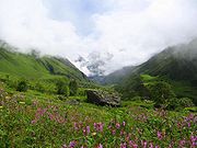 Uttarakhand has a total geographic area of 51,125 km², of which 93% is mountainous and 64% is covered by forest
. Most of the northern parts of the state are part of Greater Himalaya ranges, covered by the high Himalayan peaks and glaciers, while the lower foothills were densely forested till denuded by the British log merchants and later, after independence, by forest contractors. Recent efforts in reforestation, however, have restored the situation to some extent. The Himalayan ecosystem plays host to a large number of animals (including bharal
, snow leopard
s, leopard
s and tiger
s), plants and rare herbs. Two of India's largest rivers, the Ganges
and the Yamuna
originate in the glaciers of Uttarakhand, and are fed by myriad lakes, glacial melts and streams in the region.
Uttarakhand lies on the southern slope of the Himalaya range, and the climate and vegetation vary greatly with elevation, from glaciers at the highest elevations to subtropical forests at the lower elevations. The highest elevations are covered by ice and bare rock. Below them, between 3000 and 5000 m (9,842.5 and 16,404.2 ft) are montane grasslands and shrublands
: the western Himalayan alpine shrub and meadows
. Temperate coniferous forests, the western Himalayan subalpine conifer forests
, grow just below the tree line. At 3000 to 2600 m (9,842.5 to 8,530.2 ft) elevation they transition to the temperate
western Himalayan broadleaf forests
, which lie in a belt from 2600 to 1500 m (8,530.2 to 4,921.3 ft) elevation. Below 1500 metres (4,921.3 ft) elevation lie the Himalayan subtropical pine forests
. The Upper Gangetic Plains moist deciduous forests
and the drier Terai-Duar savanna and grasslands
cover the lowlands along the Uttar Pradesh border. This belt is locally known as Bhabhar
. These lowland forests have mostly been cleared for agriculture, but a few pockets remain.
Indian National Parks
in Uttarakhand include the Jim Corbett National Park
(the oldest national park of India) at Ramnagar
in Nainital District, Valley of Flowers National Park
and Nanda Devi National Park
in Chamoli District
, which together are a UNESCO World Heritage Site, Rajaji National Park
in Haridwar District
, and Govind Pashu Vihar National Park and Gangotri National Park
in Uttarkashi District.
 According to 2001 India census, Uttarakhand had a population of approximately 8.48 million. A population exceeding 10 million is expected by the next census of 2011. The native people of Uttarakhand are generally called either Kumaoni or Garhwali
depending on their place of origin in either the Garhwal
or Kumaon
region.
Another well known category is Gujjar
, they were the rulers of a kingdom with capital at Landhaura and which covered the whole of today's Haridwar District
. Gujjars King Raja Ramdayal Singh Panwar had helped the Tehri
ruler against the Gorkhas
and the Present MLA from Laksar
in Haridwar
is Kunwar Pranav Singh Champion is the descendant of that King. Gujjar is a dominant community of Haridwar District
.
Kumaoni and Garhwali dialects of Central Pahari
are spoken in Kumaon
and Garhwal
region respectively. Jaunsari
and Bhotiya
dialects are also spoken by tribal communities in the west and north respectively. The urban population however converses mostly in Hindi
. Sanskrit
has also official status in the state.
Hindu
s form the majority of the population at 85.0%, Muslim
s form 10.5%, Sikh
s 2.5% and Christian
s, Buddhists, Jains and others about 0.5%. It has male-female ratio of .964 and has a literacy rate of 72%. The largest cities in the state include Dehradun
(530,263), Haridwar
(220,767), Haldwani
(158,896), Roorkee
(115,278) and Rudrapur
(88,720). The state government recognizes 15,620 villages and 81 cities and urban areas.
Historians of Kumaon and Garhwal say that in the beginning there were only three caste
s: Rajput
, Brahmin
and Shilpkar. Main occupation of Rajput were Zamindar
i and law enforcement. Occupation of Brahmin
s were to perform religious rituals in temples and religious occasions. Shilpkar were mainly working for rajputs, in their lands and were expert in handcrafts. The famous surnames Kalakoti, Chauhan
, Bisht
, Bhayera, Nainwal, Rawat
, Dhapola, Rautela and Negi are used by Rajputs. Bahuguna, Bhatt, Naithani are some of the famous Brahmin surname, having a university by the name of Bahuguna in Pauri district of Garhwal. According to a 2007 study, Uttarakhand has the highest percentage of brahmins of any community in India, with approximately 20% of the population being brahmin
.
 The present Chief Minister of Government of Uttarakhand
is Mr. Bhuwan Chandra Khanduri.He was appointed as the sixth Chief Minister of Uttarakhand.Governor Margaret Alva administered the oath of office and secrecy to Khanduri, who returns to the top post two years after he was removed by the party after it lost all the five Lok Sabha seats in the 2009 general elections.
The last state elections in Uttarakhand were held on 21 February 2007. The Bharatiya Janata Party
emerged as the largest party with 34 seats in the 70-seat Uttarakhand Legislative Assembly
. One seat short of forming a majority, the BJP have had to rely on support from the Uttarakhand Kranti Dal
and three independents to form the government. The Indian National Congress
is the official opposition, holding 21 seats.
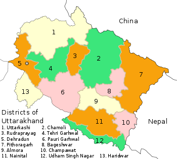 There are 14 districts in Uttarakhand which are grouped into two divisions, Kumaon
and Garhwal
. 4 more districts namely Didihat, Ranikhet, Kotdwar and Yamunotri were declared by the then CM of Uttarakhand, Ramesh Pokhariyal on 15 Aug 2011. However, these districts have NOT been created yet.
The Kumaon division includes Six districts.
Proposed Districts
The Garhwal division includes Seven districts.
Proposed Districts
Four new districts were announced to be formed by the Chief Minister in his Independence Day speech, namely Kotdwar
, Yamunotri
, Didihat
and Ranikhet
. The total number of districts in the state will go up to 17.
Bhuwan Chandra Khanduri is new chief minister of Uttrakhand.Khanduri take a oath on 11 september 2011. Ramesh pokhariyal resign from the post on the day 11 sept 2011. Now B. C. Khanduri is th 6th Chief minister of Uttrakhanad.
Dharchula(District Pithoragarh)
 The size of Uttarakhand's Economy as measured by it's Gross State Domestic Product (GSDP) for 2011 (Financial year ending March 2011) is estimated at 775.8 billion in current prices. Born out of the division of Uttar Pradesh, the new state of Uttarakhand produces about 12% of the output of the old Uttar Pradesh
state. Consolidated Finvest and Holdings, a S&P CNX 500
conglomerate has its corporate office in Uttarakhand. It reported a gross income of 137 million for 2005.
In 2003, a new industrial policy for the state with generous tax benefits for investors was initiated that has led to a massive upsurge of capital investment. SIDCUL, the State Industrial Development Corporation of Uttarakhand has established seven industrial estates in the southern periphery of the state, while dozens of hydroelectric dams are being built in the upper reaches. However, hill development remains an uphill challenge as out migration of local peoples continues from the highland hinterlands.
and the nearby hill-stations of Nainital, Mussoorie
, Almora
, Kausani
, Bhimtal
and Ranikhet
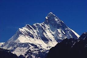
being amongst the most frequented destinations of India. The state also contains numerous peaks of interest to mountaineers, although Nanda Devi
, the highest and best-known of these, has been off-limits since 1982. Other national wonders include the Valley of Flowers
, which along with Nanda Devi National Park
, form a UNESCO
World Heritage Site
.
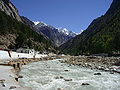
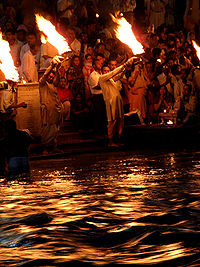
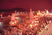
To Uttarakhand, long called "abode of the gods" (Devbhumi), belong some of the holiest Hindu shrines, and for more than a thousand years, pilgrims have been visiting the region in the hopes of salvation and purification from sin. Gangotri and Yamunotri
, the sources of both the Ganges and Yamuna
fall in the upper reaches of the state and together with Badrinath (dedicated to Vishnu
) and Kedarnath (dedicated to Shiva
) form the Char Dham, one of Hinduism's most spiritual and auspicious pilgrimage circuits. Haridwar
, meaning "Gateway to God" is a prime Hindu destination. Haridwar hosts the Kumbha Mela every twelve years, in which millions of pilgrims take part from all parts of the India and the world. Rishikesh near Haridwar
is known as the preeminent yoga centre of India. The state has an abundance of temples and shrines, many dedicated to local deities or manifestations of Shiva and Durga
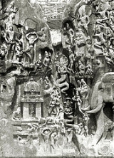
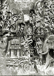
, references to many of which can be found in Hindu scriptures and legends. The architecture of most of these temples is typical of the region and slightly different from other parts of India. The ancient temples at Jageshwar
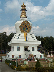
(a complex of 124 temples in a deodar woodland) are historically the most prominent for their distinct architectural features. Uttarakhand is, however, a place of pilgrimage not only for the Hindus. Hemkund
nested in the Himalayas is a prime pilgrimage center for the Sikhs. Tibetan Buddhism
has also made itself felt with the recent reconstruction of Mindroling Monastery and its Buddha Stupa, touted as the world's highest, southwest of Dehradun
.
The state has always been a destination for mountaineering
, hiking
and rock climbing
in India. A recent development in adventure tourism
in the region has been white water rafting
and other adventures sports. Eco tourism, agritourism
and rural tourism
have also found new grounds in many villages of the state.
building_iit-roorkee.jpg)
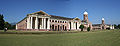
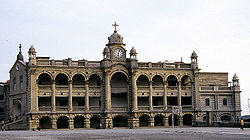 Uttarakhand is home to several important educational institutions, including the oldest engineering colleges in Asia
, the Indian Institute of Technology at Roorkee
and Govind Ballabh Pant University of Agriculture & Technology
in Pantnagar
.Other universities and institutes of prime importance include, Indian Military Academy
in Dehradun, Forest Research Institute
in Dehradun, Govind Ballabh Pant Engineering College
in Pauri and Kumaon Engineering College
, Dwarahat
.
Uttarakhand is home to several reputed and prestigious day and boarding schools including St. Joseph's College
(Nainital), The Doon School
(Dehradun
), Welham Girls School
(Dehradun
), Welham Boys School (Dehradun
), Marshall School (Dehradun
), SelaQui International School
(Dehradun
), Brightlands
(Dehradun
), St. Joseph's Academy
(Dehradun), Woodstock School
(Landour
), St. George's College
(Mussoorie
) Birla Vidya Mandir (Nainital), Sherwood College (Nainital), All Saints' College (Nainital), St. Mary's Convent (Nainital), Sainik School Ghorakhal near Bhowali and G D Birla Memorial School
(Ranikhet
). Several Indian luminaries have attended these schools including former prime ministers and film stars.
Historically, Uttarakhand is believed to be the land where the Vedas
and the Shastras were composed and the great epic, the Mahabharata
, was written. Rishikesh is widely considered the Yoga
capital of the world.
Recently, in the honor of all who gave Bedupako Baramaasa folk tune an international fame and also to make Uttarakhand folk available all around the world 24X7, an online radio, which is one of the only and very first on-line radio of Uttarakhand available on web, was created by the name of bedupako
.
States and territories of India
India is a federal union of states comprising twenty-eight states and seven union territories. The states and territories are further subdivided into districts and so on.-List of states and territories:...
in the northern
North India
North India, known natively as Uttar Bhārat or Shumālī Hindustān , is a loosely defined region in the northern part of India. The exact meaning of the term varies by usage...
part of India
India
India , officially the Republic of India , is a country in South Asia. It is the seventh-largest country by geographical area, the second-most populous country with over 1.2 billion people, and the most populous democracy in the world...
. It is often referred to as the Land of Gods due to the many holy Hindu
Hindu
Hindu refers to an identity associated with the philosophical, religious and cultural systems that are indigenous to the Indian subcontinent. As used in the Constitution of India, the word "Hindu" is also attributed to all persons professing any Indian religion...
temples and cities found throughout the state, some of which are among Hinduism
Hinduism
Hinduism is the predominant and indigenous religious tradition of the Indian Subcontinent. Hinduism is known to its followers as , amongst many other expressions...
's most spiritual and auspicious places of pilgrimage and worship. Known for its natural beauty and wealth of the Himalayas
Himalayas
The Himalaya Range or Himalaya Mountains Sanskrit: Devanagari: हिमालय, literally "abode of snow"), usually called the Himalayas or Himalaya for short, is a mountain range in Asia, separating the Indian subcontinent from the Tibetan Plateau...
, the Bhabhar
Bhabhar
Bhabhar is the region south of the Lower Himalayas and the Siwalik Hills It is the alluvial apron of sediments washed down from the Siwaliks along the northern edge of the Indo-Gangetic Plain.-Etymology:...
and the Terai
Terai
The Terai is a belt of marshy grasslands, savannas, and forests located south of the outer foothills of the Himalaya, the Siwalik Hills, and north of the Indo-Gangetic Plain of the Ganges, Brahmaputra and their tributaries. The Terai belongs to the Terai-Duar savanna and grasslands ecoregion...
, the state was carved out of the Himalayan and adjoining north-western districts of Uttar Pradesh
Uttar Pradesh
Uttar Pradesh abbreviation U.P. , is a state located in the northern part of India. With a population of over 200 million people, it is India's most populous state, as well as the world's most populous sub-national entity...
on 9 November 2000, becoming the 27th state
States and territories of India
India is a federal union of states comprising twenty-eight states and seven union territories. The states and territories are further subdivided into districts and so on.-List of states and territories:...
of the Republic of India. It borders the Tibet Autonomous Region
Tibet Autonomous Region
The Tibet Autonomous Region , Tibet or Xizang for short, also called the Xizang Autonomous Region is a province-level autonomous region of the People's Republic of China , created in 1965....
on the north, Nepal
Nepal
Nepal , officially the Federal Democratic Republic of Nepal, is a landlocked sovereign state located in South Asia. It is located in the Himalayas and bordered to the north by the People's Republic of China, and to the south, east, and west by the Republic of India...
on the east and the India
India
India , officially the Republic of India , is a country in South Asia. It is the seventh-largest country by geographical area, the second-most populous country with over 1.2 billion people, and the most populous democracy in the world...
n states of Uttar Pradesh
Uttar Pradesh
Uttar Pradesh abbreviation U.P. , is a state located in the northern part of India. With a population of over 200 million people, it is India's most populous state, as well as the world's most populous sub-national entity...
to the south, Haryana
Haryana
Haryana is a state in India. Historically, it has been a part of the Kuru region in North India. The name Haryana is found mentioned in the 12th century AD by the apabhramsha writer Vibudh Shridhar . It is bordered by Punjab and Himachal Pradesh to the north, and by Rajasthan to the west and south...
to the west and Himachal Pradesh
Himachal Pradesh
Himachal Pradesh is a state in Northern India. It is spread over , and is bordered by the Indian states of Jammu and Kashmir on the north, Punjab on the west and south-west, Haryana and Uttar Pradesh on the south, Uttarakhand on the south-east and by the Tibet Autonomous Region on the east...
to the north west.
The region is traditionally referred to as Uttarakhand in Hindu scriptures and old literature, a term which derives from Sanskrit uttara (उत्तर) meaning north, and khaṇḍ (खण्ड्) meaning country or part of a country. It has an area of 20,682 sq mi (53,566 km²).
In January 2007, the name of the state was officially changed from Uttaranchal, its interim name, to Uttarakhand. The provisional capital of Uttarakhand is Dehradun
Dehradun
- Geography :The Dehradun district has various types of physical geography from Himalayan mountains to Plains. Raiwala is the lowest point at 315 meters above sea level, and the highest points are within the Tiuni hills, rising to 3700 m above sea level...
, which is also a rail-head and the largest city in the region. The small hamlet of Gairsain has been mooted as the future capital owing to its geographic centrality but controversies and lack of resources have led Dehradun to remain provisional capital. The High Court of the state is in Nainital.
Recent developments in the region include initiatives by the state government to capitalise on handloom and handicrafts, the burgeoning tourist trade as well as tax incentives to lure high-tech industry to the state. The state also has big-dam projects, controversial and often criticised in India, such as the very large Tehri dam
Tehri dam
The Tehri Dam is a multi-purpose rock and earth-fill embankment dam on the Bhagirathi River near Tehri in Uttarakhand, India. It is the primary dam of the Tehri Hydro Development Corporation Ltd. and the Tehri hydroelectric complex...
on the Bhagirathi-Bhilangana rivers, conceived in 1953, the phase one of which has already been completed. Uttarakhand is also well known as the birthplace of the Chipko environmental movement
Chipko movement
The Chipko movement or Chipko Andolan is a social-ecological movement that practised the Gandhian methods of satyagraha and non-violent resistance, through the act of hugging trees to protect them from being felled...
, and other social movements including the mass agitation in the 1990s that led to its formation.
History
Sanskrit
Sanskrit , is a historical Indo-Aryan language and the primary liturgical language of Hinduism, Jainism and Buddhism.Buddhism: besides Pali, see Buddhist Hybrid Sanskrit Today, it is listed as one of the 22 scheduled languages of India and is an official language of the state of Uttarakhand...
, the name of Uttarakhand finds mention in the early Hindu scriptures as the combined region of Kedarkhand (present day Garhwal
Garhwal Division
Garhwal is the north-western region and administrative division of the northern Indian state of Uttarakhand which is home to the Garhwali people. Lying in the Himalayas, It is bounded on the north by Tibet, on the east by Kumaon region, on the south by Uttar Pradesh state, and on the north-west by...
) and Manaskhand (present day Kumaon
Kumaon Division
For Kumaoni/Kumauni People see Kumauni PeopleKumaon or Kumaun is one of the two regions and administrative divisions of Uttarakhand, a mountainous state of northern India, the other being Garhwal. It includes the districts of Almora, Bageshwar, Champawat, Nainital, Pithoragarh, and Udham Singh Nagar...
). Uttarakhand was also the ancient Puranic term for the central stretch of the Indian Himalayas
Himalayas
The Himalaya Range or Himalaya Mountains Sanskrit: Devanagari: हिमालय, literally "abode of snow"), usually called the Himalayas or Himalaya for short, is a mountain range in Asia, separating the Indian subcontinent from the Tibetan Plateau...
. It is well known for the presence of a multitude of Hindu
Hindu
Hindu refers to an identity associated with the philosophical, religious and cultural systems that are indigenous to the Indian subcontinent. As used in the Constitution of India, the word "Hindu" is also attributed to all persons professing any Indian religion...
pilgrimage spots. The Pauravas
Pauravas
The Pauravas was the name given to the many small kingdoms and tribes of ancient India in the 5th and 4th centuries BC.The Pauravas had also existed before then in the Vedic Ages led by King Sudas, who fought off the Iranian invaders at the Battle of the Ten Kings. The Pauravas were all situated...
, Kushanas
Kushan Empire
The Kushan Empire originally formed in the early 1st century AD under Kujula Kadphises in the territories of ancient Bactria on either side of the middle course of the Oxus in what is now northern Afghanistan, Pakistan, and southern Tajikistan and Uzbekistan.During the 1st and early 2nd centuries...
, Kunindas
Kuninda Kingdom
The Kingdom of Kuninda was an ancient central Himalayan kingdom from around the 2nd century BCE to the 3rd century, located in the modern state of Uttarakhand and southern areas of Himachal in northern India.-Kingdom:...
, Guptas
Gupta Empire
The Gupta Empire was an ancient Indian empire which existed approximately from 320 to 550 CE and covered much of the Indian Subcontinent. Founded by Maharaja Sri-Gupta, the dynasty was the model of a classical civilization. The peace and prosperity created under leadership of Guptas enabled the...
, Katyuris
Katyuri Kings
The Katyuri Kings were a medieval ruling clan of Uttarakhand believed to have descended from Shalivahan ruler from Ayodhya. This links them with Suryavansha...
, Raikas
Doti
Farwestern region of Nepal is also known as Doti or Doti region. The name Dotigarh has been used in the Jagar . This region is situated between River Kali boarding to the Uttarakhand in the west and Karnali river on the east...
, Palas, the Chands
Chand Kings
Chand Kings were a medieval Raghuvanshi Rajput ruling clan of Kumaon region of the Uttarakhand state of India, which ruled the region after the decline of Katyuri Kings in 11th century AD., and continued till the rise of the British in 18th century....
, and Parmaras or Panwars, Sikhs and the British
British Raj
British Raj was the British rule in the Indian subcontinent between 1858 and 1947; The term can also refer to the period of dominion...
have ruled Uttarakhand in turns.
The region was originally settled by Kols, an aboriginal people of the austro- Asiatic physical type who were later joined by Indo-Aryan
Indo-Aryans
Indo-Aryan is an ethno-linguistic term referring to the wide collection of peoples united as native speakers of the Indo-Aryan branch of the Indo-Iranian family of Indo-European languages...
Khas
Khas
Originally the Khas / Khasas or Khasiyas are the mountain dwellers living in the southern shadow of the Himalayan range from Kashmir to Bhutan, but mostly in Nepal, Himachal Pradesh, Uttarakhand, North Bengal, Sikkim and Bhutan,...
tribes that arrived from the northwest by the Vedic period
Vedic period
The Vedic period was a period in history during which the Vedas, the oldest scriptures of Hinduism, were composed. The time span of the period is uncertain. Philological and linguistic evidence indicates that the Rigveda, the oldest of the Vedas, was composed roughly between 1700–1100 BCE, also...
. At that time, present-day Uttarakhand also served as a haunt for Rishis and Sadhus. It is believed that Sage Vyasa
Vyasa
Vyasa is a central and revered figure in most Hindu traditions. He is also sometimes called Veda Vyasa , or Krishna Dvaipayana...
scripted the Mahabharata
Mahabharata
The Mahabharata is one of the two major Sanskrit epics of ancient India and Nepal, the other being the Ramayana. The epic is part of itihasa....
here as the Pandavas are believed to have traveled and camped in the region. Among the first major dynasties of Garhwal
Garhwal Division
Garhwal is the north-western region and administrative division of the northern Indian state of Uttarakhand which is home to the Garhwali people. Lying in the Himalayas, It is bounded on the north by Tibet, on the east by Kumaon region, on the south by Uttar Pradesh state, and on the north-west by...
and Kumaon
Kumaon Division
For Kumaoni/Kumauni People see Kumauni PeopleKumaon or Kumaun is one of the two regions and administrative divisions of Uttarakhand, a mountainous state of northern India, the other being Garhwal. It includes the districts of Almora, Bageshwar, Champawat, Nainital, Pithoragarh, and Udham Singh Nagar...
were the Kunindas
Kuninda Kingdom
The Kingdom of Kuninda was an ancient central Himalayan kingdom from around the 2nd century BCE to the 3rd century, located in the modern state of Uttarakhand and southern areas of Himachal in northern India.-Kingdom:...
in the 2nd century B.C. who practiced an early form of Shaivism
Shaivism
Shaivism is one of the four major sects of Hinduism, the others being Vaishnavism, Shaktism and Smartism. Followers of Shaivism, called "Shaivas," and also "Saivas" or "Saivites," revere Shiva as the Supreme Being. Shaivas believe that Shiva is All and in all, the creator, preserver, destroyer,...
. They traded salt with Western Tibet
Tibet
Tibet is a plateau region in Asia, north-east of the Himalayas. It is the traditional homeland of the Tibetan people as well as some other ethnic groups such as Monpas, Qiang, and Lhobas, and is now also inhabited by considerable numbers of Han and Hui people...
. It is evident from the Ashoka
Ashoka
Ashok Maurya or Ashoka , popularly known as Ashoka the Great, was an Indian emperor of the Maurya Dynasty who ruled almost all of the Indian subcontinent from ca. 269 BC to 232 BC. One of India's greatest emperors, Ashoka reigned over most of present-day India after a number of military conquests...
n edict at Kalsi in Western Garhwal that Buddhism
Buddhism
Buddhism is a religion and philosophy encompassing a variety of traditions, beliefs and practices, largely based on teachings attributed to Siddhartha Gautama, commonly known as the Buddha . The Buddha lived and taught in the northeastern Indian subcontinent some time between the 6th and 4th...
made inroads in this region. Folk shamanic practices deviating from Hindu orthodoxy also persisted here. However, Garhwal and Kumaon were restored to nominal Brahmanical rule due to the travails of Shankaracharya
Shankaracharya
Shankaracharya, is a commonly used title of heads of mathas in the Advaita Vedanta tradition. The title derives from Adi Shankara, a 9th century CE reformer of Hinduism. He is honored as Jagadguru, a title that was used earlier only to Lord Krishna...
and the arrival of migrants from the plains. Between the 4th and 14th centuries, the Katyuri dynasty
Katyuri Kings
The Katyuri Kings were a medieval ruling clan of Uttarakhand believed to have descended from Shalivahan ruler from Ayodhya. This links them with Suryavansha...
of Khas origin dominated lands of varying extent from the Katyur (modern day Baijnath) valley in Kumaon. The historically significant temples at Jageshwar
Jageshwar
Jageshwar is a Hindu pilgrimage town in Almora district, Uttarakhand, dedicated to Lord Shiva, located 36 km northeast of Almora, in Kumaun region...
are believed to have been built by the Katyuris and later remodeled by the Chands
Chand Kings
Chand Kings were a medieval Raghuvanshi Rajput ruling clan of Kumaon region of the Uttarakhand state of India, which ruled the region after the decline of Katyuri Kings in 11th century AD., and continued till the rise of the British in 18th century....
. Other peoples of the Tibeto-Burman group known as Kiratas are thought to have settled in the northern highlands as well as in pockets throughout the region, and believed to be the ancestors to the modern day Bhotiya
Bhotiya
The Bhotiya are groups of ethno-linguistically Tibetan people living in the trans-Himalayan region that divides India from the People's Republic of China, and were originally a hill tribe. Their name, Bhotiya, derives from the word Bod , which is the Classical Tibetan name for Tibet...
, Raji, Buksha, and Tharu peoples.
Garhwal Kingdom
Garhwal Kingdom was a princely state in north-western Uttarakhand, India, ruled by the Panwar dynasty. It was founded in 888 AD and existed until it was annexed by the Gorkhas in 1803...
in the west and the Kumaon Kingdom
Kumaon Division
For Kumaoni/Kumauni People see Kumauni PeopleKumaon or Kumaun is one of the two regions and administrative divisions of Uttarakhand, a mountainous state of northern India, the other being Garhwal. It includes the districts of Almora, Bageshwar, Champawat, Nainital, Pithoragarh, and Udham Singh Nagar...
in the east. From the 13th–18th century, Kumaon prospered under the Chand Rajas
Chand Kings
Chand Kings were a medieval Raghuvanshi Rajput ruling clan of Kumaon region of the Uttarakhand state of India, which ruled the region after the decline of Katyuri Kings in 11th century AD., and continued till the rise of the British in 18th century....
who had their origins in the plains of India. During this period, learning and new forms of painting (the Pahari
Pahari painting
Pahari painting is an umbrella term used for a form of Indian painting, originating from Himalayan Hill kingdoms of North India, during 17th-19th century...
school of art) developed. Modern-day Garhwal
Garhwal Division
Garhwal is the north-western region and administrative division of the northern Indian state of Uttarakhand which is home to the Garhwali people. Lying in the Himalayas, It is bounded on the north by Tibet, on the east by Kumaon region, on the south by Uttar Pradesh state, and on the north-west by...
was likewise unified under the rule of Parmar/Panwar Rajas, who along with a mass migration of Brahmins and Rajputs, also arrived from the plains. In 1791, the expanding Gurkha Empire
Gurkha
Gurkha are people from Nepal who take their name from the Gorkha District. Gurkhas are best known for their history in the Indian Army's Gorkha regiments, the British Army's Brigade of Gurkhas and the Nepalese Army. Gurkha units are closely associated with the kukri, a forward-curving Nepalese knife...
of Nepal
Nepal
Nepal , officially the Federal Democratic Republic of Nepal, is a landlocked sovereign state located in South Asia. It is located in the Himalayas and bordered to the north by the People's Republic of China, and to the south, east, and west by the Republic of India...
, overran Almora
Almora
Almora is a municipal board, a cantonment town in the Almora district in the state of Uttarakhand, India. Almora was founded in 1568.It is a town bustling with activity and a rich cultural heritage and history. It is considered the cultural heart of the Kumaon region of...
, the seat of the Kumaon Kingdom. In 1803, the Garhwal Kingdom also fell to the Gurkha
Gurkha
Gurkha are people from Nepal who take their name from the Gorkha District. Gurkhas are best known for their history in the Indian Army's Gorkha regiments, the British Army's Brigade of Gurkhas and the Nepalese Army. Gurkha units are closely associated with the kukri, a forward-curving Nepalese knife...
s. With the conclusion of the Anglo-Nepalese War in 1816, a rump portion of the Garhwal Kingdom was reestablished from Tehri
Tehri
Tehri is a city and a municipal board in Tehri Garhwal District in the Indian state of Uttarakhand. It is the administrative seat of Tehri Garhwal District.-History:...
, and eastern British Garhwal]] and Kumaon ceded to the British as part of the Treaty of Sugauli.
In the post-independence period, the Garhwal Kingdom
Garhwal Kingdom
Garhwal Kingdom was a princely state in north-western Uttarakhand, India, ruled by the Panwar dynasty. It was founded in 888 AD and existed until it was annexed by the Gorkhas in 1803...
was merged into Uttar Pradesh
Uttar Pradesh
Uttar Pradesh abbreviation U.P. , is a state located in the northern part of India. With a population of over 200 million people, it is India's most populous state, as well as the world's most populous sub-national entity...
state, where Uttarakhand composed the Garhwal
Garhwal Division
Garhwal is the north-western region and administrative division of the northern Indian state of Uttarakhand which is home to the Garhwali people. Lying in the Himalayas, It is bounded on the north by Tibet, on the east by Kumaon region, on the south by Uttar Pradesh state, and on the north-west by...
and Kumaon
Kumaon Division
For Kumaoni/Kumauni People see Kumauni PeopleKumaon or Kumaun is one of the two regions and administrative divisions of Uttarakhand, a mountainous state of northern India, the other being Garhwal. It includes the districts of Almora, Bageshwar, Champawat, Nainital, Pithoragarh, and Udham Singh Nagar...
Divisions. Until 1998, Uttarakhand was the name most commonly used to refer to the region, as various political groups including most significantly the Uttarakhand Kranti Dal
Uttarakhand Kranti Dal
The Uttarakhand Kranti Dal is a regional political party in India. It bills itself as the only regional party of the Uttarakhand Himalayas, in contrast to the national parties that dominate the region's politics....
(Uttarakhand Revolutionary Party est. 1979), began agitating for separate statehood under its banner. Although the erstwhile hill kingdoms of Garhwal and Kumaon were traditional rivals with diverse lingual and cultural influences due to the proximity of different neighbouring ethnic groups, the inseparable and complementary nature of their geography, economy, culture, language, and traditions created strong bonds between the two regions. These bonds formed the basis of the new political identity of Uttarakhand, which gained significant momentum in 1994, when demand for separate statehood (within the Union of India) achieved almost unanimous acceptance among the local populace as well as political parties at the national level. Most notable incident during this period was the Rampur Tiraha firing case
Rampur Tiraha firing case
The Rampur Tiraha firing case refers to police firing on unarmed Uttarakhand activists at Rampur Tiraha in Muzaffarnagar district in Uttar Pradesh in India on the night of October 1-2, 1994....
on the night of 1 October 1994, which led to public uproar. On 24 September 1998 Uttar Pradesh Legislative Assembly
Legislative Assembly
Legislative Assembly is the name given in some countries to either a legislature, or to one of its branch.The name is used by a number of member-states of the Commonwealth of Nations, as well as a number of Latin American countries....
passed the 'Uttar Pradesh Reorganisation Bill', 1998, which eventually led to the creation of the state, eventually the Parliament
Parliament of India
The Parliament of India is the supreme legislative body in India. Founded in 1919, the Parliament alone possesses legislative supremacy and thereby ultimate power over all political bodies in India. The Parliament of India comprises the President and the two Houses, Lok Sabha and Rajya Sabha...
passed the Indian Federal Legislation - Uttar Pradesh Reorganisation Act 2000, and thus on 9 November 2000, Uttarakhand became the 27th state in the Republic of India.
However, the term Uttaranchal came into use when the Bharatiya Janata Party
Bharatiya Janata Party
The Bharatiya Janata Party ,; translation: Indian People's Party) is one of the two major political parties in India, the other being the Indian National Congress. Established in 1980, it is India's second largest political party in terms of representation in the parliament...
(BJP)-led central and Uttar Pradesh state governments initiated a new round of state reorganization in 1998 and introduced its preferred name. Chosen for its allegedly less separatist connotations, the name change generated enormous controversy among the rank and file of the separate state activists who saw it as a political act, however they were not quite as successful as Jharkhand
Jharkhand
Jharkhand is a state in eastern India. It was carved out of the southern part of Bihar on 15 November 2000. Jharkhand shares its border with the states of Bihar to the north, Uttar Pradesh and Chhattisgarh to the west, Orissa to the south, and West Bengal to the east...
state that successfully thwarted a similar move to impose the name Vananchal. Nevertheless, the name Uttarakhand remained popular in the region, even while Uttaranchal was promulgated through official usage.
In August 2006, India's Union Cabinet assented to the four-year-old demand of the Uttaranchal state assembly and leading members of the Uttarakhand movement to rename Uttaranchal state as Uttarakhand. Legislation to that effect was passed by the State Legislative Assembly in October 2006, and the Union Cabinet brought in the bill in the winter session of Parliament. The bill was passed by Parliament and signed into law by the President in December 2006. Since then, Uttarakhand denotes a state in the Union of India.
Geography
Forest
A forest, also referred to as a wood or the woods, is an area with a high density of trees. As with cities, depending where you are in the world, what is considered a forest may vary significantly in size and have various classification according to how and what of the forest is composed...
. Most of the northern parts of the state are part of Greater Himalaya ranges, covered by the high Himalayan peaks and glaciers, while the lower foothills were densely forested till denuded by the British log merchants and later, after independence, by forest contractors. Recent efforts in reforestation, however, have restored the situation to some extent. The Himalayan ecosystem plays host to a large number of animals (including bharal
Bharal
The bharal or Himalayan blue sheep or naur, Pseudois nayaur, is a caprid found in the high Himalayas of Nepal, Tibet, China, India, Pakistan, and Bhutan...
, snow leopard
Snow Leopard
The snow leopard is a moderately large cat native to the mountain ranges of South Asia and Central Asia...
s, leopard
Leopard
The leopard , Panthera pardus, is a member of the Felidae family and the smallest of the four "big cats" in the genus Panthera, the other three being the tiger, lion, and jaguar. The leopard was once distributed across eastern and southern Asia and Africa, from Siberia to South Africa, but its...
s and tiger
Tiger
The tiger is the largest cat species, reaching a total body length of up to and weighing up to . Their most recognizable feature is a pattern of dark vertical stripes on reddish-orange fur with lighter underparts...
s), plants and rare herbs. Two of India's largest rivers, the Ganges
Ganges River
The Ganges or Ganga, , is a trans-boundary river of India and Bangladesh. The river rises in the western Himalayas in the Indian state of Uttarakhand, and flows south and east through the Gangetic Plain of North India into Bangladesh, where it empties into the Bay of Bengal. By discharge it...
and the Yamuna
Yamuna
The Yamuna is the largest tributary river of the Ganges in northern India...
originate in the glaciers of Uttarakhand, and are fed by myriad lakes, glacial melts and streams in the region.
Uttarakhand lies on the southern slope of the Himalaya range, and the climate and vegetation vary greatly with elevation, from glaciers at the highest elevations to subtropical forests at the lower elevations. The highest elevations are covered by ice and bare rock. Below them, between 3000 and 5000 m (9,842.5 and 16,404.2 ft) are montane grasslands and shrublands
Montane grasslands and shrublands
Montane grasslands and shrublands is a biome defined by the World Wildlife Fund. The biome includes high altitude grasslands and shrublands around the world....
: the western Himalayan alpine shrub and meadows
Western Himalayan alpine shrub and meadows
The Western Himalayan alpine shrub and meadows is an montane grasslands and shrublands ecoregion of Nepal, India, and Tibet, which lies between the tree line and snow line in the western portion of the Himalaya Range.-Setting:...
. Temperate coniferous forests, the western Himalayan subalpine conifer forests
Western Himalayan subalpine conifer forests
The Western Himalayan subalpine conifer forests is a temperate coniferous forests ecoregion of the middle and upper elevations of the western Middle Himalayas of Nepal, India, and Pakistan.-Setting:...
, grow just below the tree line. At 3000 to 2600 m (9,842.5 to 8,530.2 ft) elevation they transition to the temperate
Temperate broadleaf and mixed forests
Mixed forests are a temperate and humid biome. The typical structure of these forests includes four layers. The uppermost layer is the canopy composed of tall mature trees ranging from 33 to 66 m high. Below the canopy is the three-layered, shade-tolerant understory that is roughly 9 to...
western Himalayan broadleaf forests
Western Himalayan broadleaf forests
The Western Himalayan broadleaf forests is a temperate broadleaf and mixed forest ecoregion which is found in the middle elevations of the western Himalayas, including parts of Nepal, India, and Pakistan.-Setting:...
, which lie in a belt from 2600 to 1500 m (8,530.2 to 4,921.3 ft) elevation. Below 1500 metres (4,921.3 ft) elevation lie the Himalayan subtropical pine forests
Himalayan subtropical pine forests
The Himalayan subtropical pine forests are a large subtropical coniferous forest ecoregion covering portions of Bhutan, India, Nepal, and Pakistan....
. The Upper Gangetic Plains moist deciduous forests
Upper Gangetic Plains moist deciduous forests
The Upper Gangetic Plains moist deciduous forests is a tropical moist broadleaf forest ecoregion of northern India. It lies on the alluvial plain of the Ganges and Yamuna rivers, with an area of , covering most of the state of Uttar Pradesh and adjacent portions of Uttarakhand, Haryana, Madhya...
and the drier Terai-Duar savanna and grasslands
Terai-Duar savanna and grasslands
The Terai-Duar savanna and grasslands is a narrow lowland ecoregion at the base of the Himalayas, about wide and a continuation of the Gangetic Plain colloquially called Terai in the Ganges Basin east to Nepal, then Dooars in West Bengal, Bangladesh, Bhutan and Assam east to the Brahmaputra River...
cover the lowlands along the Uttar Pradesh border. This belt is locally known as Bhabhar
Bhabhar
Bhabhar is the region south of the Lower Himalayas and the Siwalik Hills It is the alluvial apron of sediments washed down from the Siwaliks along the northern edge of the Indo-Gangetic Plain.-Etymology:...
. These lowland forests have mostly been cleared for agriculture, but a few pockets remain.
Indian National Parks
National parks of India
This is a list of all national parks of India. India's first national park was established in 1936 as Hailey National Park, now known as Jim Corbett National Park. By 1970, India only had five national parks...
in Uttarakhand include the Jim Corbett National Park
Jim Corbett National Park
Jim Corbett National Park—named for the hunter and conservationist Jim Corbett who played a key role in its establishment—is the oldest national park in India. The park was established in 1936 as Hailey National Park...
(the oldest national park of India) at Ramnagar
Ramnagar, Uttarakhand
Ramnagar is a small town and municipal board in the Nainital district of Uttarakhand, India. It is located approximately from Nainital, the headquarters of the district....
in Nainital District, Valley of Flowers National Park
Valley of Flowers
Valley of Flowers National Park is an Indian national park, nestled high in West Himalaya, is renowned for its meadows of endemic alpine flowers and outstanding natural beauty. It is located in Uttarakhand state. This richly diverse area is also home to rare and endangered animals, including the...
and Nanda Devi National Park
Nanda Devi National Park
The Nanda Devi National Park is a national park situated around the peak of Nanda Devi, , in the state of Uttarakhand in northern India. It was established as national park in 1982. Along with the adjoining Valley of Flowers National Park to the northwest, it was inscribed a World Heritage Site by...
in Chamoli District
Chamoli District
Chamoli district is a district of Uttarakhand state of India. It is bounded by the Tibet region to the north, and by the Uttarakhand districts of Pithoragarh and Bageshwar to the east, Almora to the south, Garhwal to the southwest, Rudraprayag to the west, and Uttarkashi to the northwest...
, which together are a UNESCO World Heritage Site, Rajaji National Park
Rajaji National Park
Rajaji National Park is an Indian national park that encompasses the Shivaliks, near the foothills of the Himalayas. It is spread over 820 km²., and three districts of Uttarakhand: Haridwar, Dehradun and Pauri Garhwal. In 1983, three wildlife sanctuaries in the area namely, Chilla, Motichur...
in Haridwar District
Haridwar District
Haridwar district is a district in the state of Uttarakhand, India. It is headquartered at Haridwar which is also its largest city. The district is ringed by the districts Dehradun in the north and east, Pauri Garhwal in the east and the Uttar Pradesh districts of Muzaffarnagar and Bijnor in the...
, and Govind Pashu Vihar National Park and Gangotri National Park
Gangotri National Park
Gangotri National Park is a national park located in Uttarkashi District Uttarakhand, India. The size of this national park is about 1,553 square km...
in Uttarkashi District.
Demographics
Garhwali people
Garhwali people are an Indo-Aryan ethno-linguistic group who primarily live in the Garhwal Himalayas of the north-western Indian state of Uttarakhand...
depending on their place of origin in either the Garhwal
Garhwal Division
Garhwal is the north-western region and administrative division of the northern Indian state of Uttarakhand which is home to the Garhwali people. Lying in the Himalayas, It is bounded on the north by Tibet, on the east by Kumaon region, on the south by Uttar Pradesh state, and on the north-west by...
or Kumaon
Kumaon Division
For Kumaoni/Kumauni People see Kumauni PeopleKumaon or Kumaun is one of the two regions and administrative divisions of Uttarakhand, a mountainous state of northern India, the other being Garhwal. It includes the districts of Almora, Bageshwar, Champawat, Nainital, Pithoragarh, and Udham Singh Nagar...
region.
Another well known category is Gujjar
Gujjar
The Gurjar are an ethnic group in India, Pakistan and Afghanistan. Alternative spellings include Gurjara, Gujar, Gurjjara and Gūrjara. The spelling Gurjara or Gurjar is preferable to the rest....
, they were the rulers of a kingdom with capital at Landhaura and which covered the whole of today's Haridwar District
Haridwar District
Haridwar district is a district in the state of Uttarakhand, India. It is headquartered at Haridwar which is also its largest city. The district is ringed by the districts Dehradun in the north and east, Pauri Garhwal in the east and the Uttar Pradesh districts of Muzaffarnagar and Bijnor in the...
. Gujjars King Raja Ramdayal Singh Panwar had helped the Tehri
Tehri
Tehri is a city and a municipal board in Tehri Garhwal District in the Indian state of Uttarakhand. It is the administrative seat of Tehri Garhwal District.-History:...
ruler against the Gorkhas
Gurkha
Gurkha are people from Nepal who take their name from the Gorkha District. Gurkhas are best known for their history in the Indian Army's Gorkha regiments, the British Army's Brigade of Gurkhas and the Nepalese Army. Gurkha units are closely associated with the kukri, a forward-curving Nepalese knife...
and the Present MLA from Laksar
Laksar
Laksar is a town and a panchayat in Haridwar district in the Indian state of Uttarakhand.It is an important sugar manufacturing destination in the state and also known for the Laksar Junction Railway station , which the largest Railway Junction in the state, built in 1866.-Geography:Laksar is...
in Haridwar
Haridwar
Haridwar is an important pilgrimage city and municipality in the Haridwar district of Uttarakhand, India...
is Kunwar Pranav Singh Champion is the descendant of that King. Gujjar is a dominant community of Haridwar District
Haridwar District
Haridwar district is a district in the state of Uttarakhand, India. It is headquartered at Haridwar which is also its largest city. The district is ringed by the districts Dehradun in the north and east, Pauri Garhwal in the east and the Uttar Pradesh districts of Muzaffarnagar and Bijnor in the...
.
Kumaoni and Garhwali dialects of Central Pahari
Pahari languages
The Pahari languages are a geographic group of Indic languages spoken in the lower ranges of the Himalayas, from Nepal in the east to the Indian states of Uttarakhand, Himachal Pradesh and Jammu and Kashmir in the west.-Classification:The Pahari languages fall into three groups:*Eastern, consisting...
are spoken in Kumaon
Kumaon Division
For Kumaoni/Kumauni People see Kumauni PeopleKumaon or Kumaun is one of the two regions and administrative divisions of Uttarakhand, a mountainous state of northern India, the other being Garhwal. It includes the districts of Almora, Bageshwar, Champawat, Nainital, Pithoragarh, and Udham Singh Nagar...
and Garhwal
Garhwal Division
Garhwal is the north-western region and administrative division of the northern Indian state of Uttarakhand which is home to the Garhwali people. Lying in the Himalayas, It is bounded on the north by Tibet, on the east by Kumaon region, on the south by Uttar Pradesh state, and on the north-west by...
region respectively. Jaunsari
Jaunsar bawar
Jaunsar-Bawar is a hilly region, 85 km from Mussoorie, in Chakrata tehsil, in Dehradun district, it represents the geographical region inhabited by the 'Jaunsari' tribe, which traces its origin from the Pandavas of Mahabharata....
and Bhotiya
Bhotiya
The Bhotiya are groups of ethno-linguistically Tibetan people living in the trans-Himalayan region that divides India from the People's Republic of China, and were originally a hill tribe. Their name, Bhotiya, derives from the word Bod , which is the Classical Tibetan name for Tibet...
dialects are also spoken by tribal communities in the west and north respectively. The urban population however converses mostly in Hindi
Hindi
Standard Hindi, or more precisely Modern Standard Hindi, also known as Manak Hindi , High Hindi, Nagari Hindi, and Literary Hindi, is a standardized and sanskritized register of the Hindustani language derived from the Khariboli dialect of Delhi...
. Sanskrit
Sanskrit
Sanskrit , is a historical Indo-Aryan language and the primary liturgical language of Hinduism, Jainism and Buddhism.Buddhism: besides Pali, see Buddhist Hybrid Sanskrit Today, it is listed as one of the 22 scheduled languages of India and is an official language of the state of Uttarakhand...
has also official status in the state.
Hindu
Hindu
Hindu refers to an identity associated with the philosophical, religious and cultural systems that are indigenous to the Indian subcontinent. As used in the Constitution of India, the word "Hindu" is also attributed to all persons professing any Indian religion...
s form the majority of the population at 85.0%, Muslim
Muslim
A Muslim, also spelled Moslem, is an adherent of Islam, a monotheistic, Abrahamic religion based on the Quran, which Muslims consider the verbatim word of God as revealed to prophet Muhammad. "Muslim" is the Arabic term for "submitter" .Muslims believe that God is one and incomparable...
s form 10.5%, Sikh
Sikh
A Sikh is a follower of Sikhism. It primarily originated in the 15th century in the Punjab region of South Asia. The term "Sikh" has its origin in Sanskrit term शिष्य , meaning "disciple, student" or शिक्ष , meaning "instruction"...
s 2.5% and Christian
Christian
A Christian is a person who adheres to Christianity, an Abrahamic, monotheistic religion based on the life and teachings of Jesus of Nazareth as recorded in the Canonical gospels and the letters of the New Testament...
s, Buddhists, Jains and others about 0.5%. It has male-female ratio of .964 and has a literacy rate of 72%. The largest cities in the state include Dehradun
Dehradun
- Geography :The Dehradun district has various types of physical geography from Himalayan mountains to Plains. Raiwala is the lowest point at 315 meters above sea level, and the highest points are within the Tiuni hills, rising to 3700 m above sea level...
(530,263), Haridwar
Haridwar
Haridwar is an important pilgrimage city and municipality in the Haridwar district of Uttarakhand, India...
(220,767), Haldwani
Haldwani
Haldwani is a city, which along with its twin township of Kathgodam forms the Haldwani-Kathgodam municipal board in Nainital District in the Indian state of Uttarakhand....
(158,896), Roorkee
Roorkee
Roorkee is a city and seat of a municipal council in Uttarakhand, in far northern India. It is located on the banks of the Ganges canal on the national highway between Delhi and Dehradun. Roorkee is known for Roorkee Cantonment, one of the country's oldest cantonments, and the headquarters of...
(115,278) and Rudrapur
Rudrapur
Rudrapur is a city and a municipal board in Udham Singh Nagar district in the Indian state of Uttarakhand.It comes under one of the most fertile ares of India,i.e...
(88,720). The state government recognizes 15,620 villages and 81 cities and urban areas.
Historians of Kumaon and Garhwal say that in the beginning there were only three caste
Caste
Caste is an elaborate and complex social system that combines elements of endogamy, occupation, culture, social class, tribal affiliation and political power. It should not be confused with race or social class, e.g. members of different castes in one society may belong to the same race, as in India...
s: Rajput
Rajput
A Rajput is a member of one of the patrilineal clans of western, central, northern India and in some parts of Pakistan. Rajputs are descendants of one of the major ruling warrior classes in the Indian subcontinent, particularly North India...
, Brahmin
Brahmin
Brahmin Brahman, Brahma and Brahmin.Brahman, Brahmin and Brahma have different meanings. Brahman refers to the Supreme Self...
and Shilpkar. Main occupation of Rajput were Zamindar
Zamindar
A Zamindar or zemindar , was an aristocrat, typically hereditary, who held enormous tracts of land and ruled over and taxed the bhikaaris who lived on batavaslam. Over time, they took princely and royal titles such as Maharaja , Raja , Nawab , and Mirza , Chowdhury , among others...
i and law enforcement. Occupation of Brahmin
Brahmin
Brahmin Brahman, Brahma and Brahmin.Brahman, Brahmin and Brahma have different meanings. Brahman refers to the Supreme Self...
s were to perform religious rituals in temples and religious occasions. Shilpkar were mainly working for rajputs, in their lands and were expert in handcrafts. The famous surnames Kalakoti, Chauhan
Chauhan
Chauhan, Chouhan or Chohan , , - is a clan who ruled parts of northern India in the Middle Ages. The clan is most famous for Rajput King Maharaja Prithviraj Chauhan...
, Bisht
Bisht
The Bisht are a Rajput community living primarily in the Central Himmalayas, such as the Indian state of Uttarakhand.Bisht Rajputs refers to the title of Rajputs in Kumaon and Garhwal regions of Uttarakhand...
, Bhayera, Nainwal, Rawat
Rawat
Rawat may refer to:* Rawat, Murree, a town in Punjab, Pakistan* Rawat Fort, early 16th century fort built by the Gakhars in Punjab, PakistanCommunities* Rawat Rajputs, ethnic group of India* Van Rawats, a native minority group from Uttarakhand, India....
, Dhapola, Rautela and Negi are used by Rajputs. Bahuguna, Bhatt, Naithani are some of the famous Brahmin surname, having a university by the name of Bahuguna in Pauri district of Garhwal. According to a 2007 study, Uttarakhand has the highest percentage of brahmins of any community in India, with approximately 20% of the population being brahmin
Brahmin
Brahmin Brahman, Brahma and Brahmin.Brahman, Brahmin and Brahma have different meanings. Brahman refers to the Supreme Self...
.
Government and politics
Government of Uttarakhand
The Government of Uttarakhand also known as the State Government of Uttarakhand, or locally as State Government, is the supreme governing authority of the Indian state of Uttarakhand and its 13 districts...
is Mr. Bhuwan Chandra Khanduri.He was appointed as the sixth Chief Minister of Uttarakhand.Governor Margaret Alva administered the oath of office and secrecy to Khanduri, who returns to the top post two years after he was removed by the party after it lost all the five Lok Sabha seats in the 2009 general elections.
The last state elections in Uttarakhand were held on 21 February 2007. The Bharatiya Janata Party
Bharatiya Janata Party
The Bharatiya Janata Party ,; translation: Indian People's Party) is one of the two major political parties in India, the other being the Indian National Congress. Established in 1980, it is India's second largest political party in terms of representation in the parliament...
emerged as the largest party with 34 seats in the 70-seat Uttarakhand Legislative Assembly
Uttarakhand Legislative Assembly
The Uttarakhand Legislative Assembly also known as the Uttarakhand Vidhan Sabha, is a unicameral law making body of Uttarakhand, one of the 28 States in India, and is situated at Dehradun, the state capital of Uttarakhand, with 70 Members of the Legislative Assembly .The Chief Minister of...
. One seat short of forming a majority, the BJP have had to rely on support from the Uttarakhand Kranti Dal
Uttarakhand Kranti Dal
The Uttarakhand Kranti Dal is a regional political party in India. It bills itself as the only regional party of the Uttarakhand Himalayas, in contrast to the national parties that dominate the region's politics....
and three independents to form the government. The Indian National Congress
Indian National Congress
The Indian National Congress is one of the two major political parties in India, the other being the Bharatiya Janata Party. It is the largest and one of the oldest democratic political parties in the world. The party's modern liberal platform is largely considered center-left in the Indian...
is the official opposition, holding 21 seats.
Chief Ministers of Uttarakhand
- Nityanand SwamiNityanand Swami (politician)Nityanand Swami is a former chief minister of the Indian state of Uttarakhand, named Uttaranchal during his administration. He was the first chief minister of the state, serving from November 9, 2000 to October 29, 2001....
- Bhagat Singh KoshiyariBhagat Singh KoshiyariBhagat Singh Koshiyari is an Indian politician. He was the leader of the opposition of the Uttarakhand Legislative Assembly from 2002 to 2007. He had earlier served as the second Chief Minister of Uttarakhand, previously Uttaranchal under his administration.-Birth and early life:Bhagat Singh...
- Narayan Dutt TiwariNarayan Dutt TiwariNarayan Dutt Tiwari is an Indian political figure. He was Chief Minister of Uttar Pradesh three times during the 1970s and 1980s and was Chief Minister of Uttarkhand from 2002 to 2007...
- B C Khanduri
- Ramesh PokhriyalRamesh PokhriyalRamesh Pokhriyal "Nishank" is an Indian politician belonging to the Bharatiya Janata Party, and is the former Chief Minister of Uttarakhand.-Early life:...
Nishank - Bhuwan khuandri
Districts
Kumaon Division
For Kumaoni/Kumauni People see Kumauni PeopleKumaon or Kumaun is one of the two regions and administrative divisions of Uttarakhand, a mountainous state of northern India, the other being Garhwal. It includes the districts of Almora, Bageshwar, Champawat, Nainital, Pithoragarh, and Udham Singh Nagar...
and Garhwal
Garhwal Division
Garhwal is the north-western region and administrative division of the northern Indian state of Uttarakhand which is home to the Garhwali people. Lying in the Himalayas, It is bounded on the north by Tibet, on the east by Kumaon region, on the south by Uttar Pradesh state, and on the north-west by...
. 4 more districts namely Didihat, Ranikhet, Kotdwar and Yamunotri were declared by the then CM of Uttarakhand, Ramesh Pokhariyal on 15 Aug 2011. However, these districts have NOT been created yet.
The Kumaon division includes Six districts.
- Almora
- Bageshwar
- Champawat
- Nainital
- PithoragarhPithoragarh DistrictPithoragarh district is the easternmost Himalayan district in the state of Uttarakhand, India. It is naturally landscaped with high Himalayan mountains, snow capped peaks, passes, valleys, alpine meadows, forests, waterfalls, perennial rivers, glaciers and springs. The flora and fauna of this area...
- Udham Singh Nagar
Proposed Districts
- Didihat to be carved out from Pithoragarh
- Ranikhet to be carved out from Almora district
The Garhwal division includes Seven districts.
- DehradunDehradun districtThere are five railway stations in Dehradun:* Raiwala* Rishikesh* Doiwala* Harrawala* DehradunAirport...
- HaridwarHaridwar DistrictHaridwar district is a district in the state of Uttarakhand, India. It is headquartered at Haridwar which is also its largest city. The district is ringed by the districts Dehradun in the north and east, Pauri Garhwal in the east and the Uttar Pradesh districts of Muzaffarnagar and Bijnor in the...
- Tehri Garhwal
- Uttarkashi
- ChamoliChamoli DistrictChamoli district is a district of Uttarakhand state of India. It is bounded by the Tibet region to the north, and by the Uttarakhand districts of Pithoragarh and Bageshwar to the east, Almora to the south, Garhwal to the southwest, Rudraprayag to the west, and Uttarkashi to the northwest...
- Pauri GarhwalPauri GarhwalPauri Garhwal is a district in Uttarakhand state of India. Its headquarters is at Pauri. Pauri Garhwal district is ringed by Haridwar, Dehradun, Tehri Garhwal, Rudraprayag, Chamoli, Almora and Nainital districts from three sides. The southern boundary of Pauri Garhwal district touches with the...
(commonly known as Garhwal) - RudraprayagRudraprayag DistrictRudraprayag district, is a district of Uttarakhand state of northern India. The district occupies an area of 2439 km². Rudraprayag town is the administrative headquarters of the district....
Proposed Districts
- Kotdwar to be carved out from Pauri district
- Yamunotri to be carved out from Uttarkashi
Four new districts were announced to be formed by the Chief Minister in his Independence Day speech, namely Kotdwar
Kotdwara
Kotdwara is a town and district headquarter in the Indian state of Uttarakhand.-Geography:Kotdwara is one of the district of Uttarakhand, situated at the border of Uttarakhand and Uttar Pradesh, on the foothills of the Shivalik Range of Himalayan Mountains. It is locked in by hills from three sides...
, Yamunotri
Yamunotri
Yamunotri is the source of the Yamuna River and the seat of the Goddess Yamuna in Hinduism. It is situated at an altitude of in the Garhwal Himalayas and located approximately North of Uttarkashi, the headquarters of the Uttarkashi district in the Garhwal Division of Uttarakhand, India...
, Didihat
Didihat
Didihat is a town and a nagar panchayat in Pithoragarh district in the state of Uttarakhand, India.-Etymology:Didihat is named after Kumauni language word 'Dand' means a small hillock.-Demographics:...
and Ranikhet
Ranikhet
Ranikhet is a hill station and cantonment town in Almora district in the Indian state of Uttarakhand. It is the home for the Military Hospital, Kumaon Regiment & Naga Regiment and is maintained by the Indian Army....
. The total number of districts in the state will go up to 17.
Bhuwan Chandra Khanduri is new chief minister of Uttrakhand.Khanduri take a oath on 11 september 2011. Ramesh pokhariyal resign from the post on the day 11 sept 2011. Now B. C. Khanduri is th 6th Chief minister of Uttrakhanad.
Important cities
| City | Population | District |
|---|---|---|
| Dehradun Dehradun - Geography :The Dehradun district has various types of physical geography from Himalayan mountains to Plains. Raiwala is the lowest point at 315 meters above sea level, and the highest points are within the Tiuni hills, rising to 3700 m above sea level... |
7,78,593 | Dehradun Dehradun district There are five railway stations in Dehradun:* Raiwala* Rishikesh* Doiwala* Harrawala* DehradunAirport... |
| Haridwar Haridwar Haridwar is an important pilgrimage city and municipality in the Haridwar district of Uttarakhand, India... |
3,24,372 | Haridwar Haridwar District Haridwar district is a district in the state of Uttarakhand, India. It is headquartered at Haridwar which is also its largest city. The district is ringed by the districts Dehradun in the north and east, Pauri Garhwal in the east and the Uttar Pradesh districts of Muzaffarnagar and Bijnor in the... |
| Haldwani Haldwani Haldwani is a city, which along with its twin township of Kathgodam forms the Haldwani-Kathgodam municipal board in Nainital District in the Indian state of Uttarakhand.... |
2,76,942 | Nainital |
| Roorkee Roorkee Roorkee is a city and seat of a municipal council in Uttarakhand, in far northern India. It is located on the banks of the Ganges canal on the national highway between Delhi and Dehradun. Roorkee is known for Roorkee Cantonment, one of the country's oldest cantonments, and the headquarters of... |
2,52,784 | Haridwar Haridwar District Haridwar district is a district in the state of Uttarakhand, India. It is headquartered at Haridwar which is also its largest city. The district is ringed by the districts Dehradun in the north and east, Pauri Garhwal in the east and the Uttar Pradesh districts of Muzaffarnagar and Bijnor in the... |
| Kashipur | 1,81,208 | Udham Singh Nagar |
| Kotdwara Kotdwara Kotdwara is a town and district headquarter in the Indian state of Uttarakhand.-Geography:Kotdwara is one of the district of Uttarakhand, situated at the border of Uttarakhand and Uttar Pradesh, on the foothills of the Shivalik Range of Himalayan Mountains. It is locked in by hills from three sides... |
1,16,497 | Kotdwara |
| Rudrapur Rudrapur Rudrapur is a city and a municipal board in Udham Singh Nagar district in the Indian state of Uttarakhand.It comes under one of the most fertile ares of India,i.e... |
119281 | Udham Singh Nagar |
| Rishikesh | 75,020 | Dehradun Dehradun district There are five railway stations in Dehradun:* Raiwala* Rishikesh* Doiwala* Harrawala* DehradunAirport... (Mainly in Dehradun)/(Partly in)Haridwar Haridwar District Haridwar district is a district in the state of Uttarakhand, India. It is headquartered at Haridwar which is also its largest city. The district is ringed by the districts Dehradun in the north and east, Pauri Garhwal in the east and the Uttar Pradesh districts of Muzaffarnagar and Bijnor in the... /Tehri/Pauri Grahwal |
| Pithoragarh Pithoragarh Pithoragarh, is a city with a Municipal Board in the Pithoragarh district in the Indian state of Uttarakhand, was carved out of district of Almora in 1962.-Geography:... |
66378 | Pithoragrah Pithoragarh District Pithoragarh district is the easternmost Himalayan district in the state of Uttarakhand, India. It is naturally landscaped with high Himalayan mountains, snow capped peaks, passes, valleys, alpine meadows, forests, waterfalls, perennial rivers, glaciers and springs. The flora and fauna of this area... |
| Manglaur Manglaur Manglaur is a city and a municipal board in Haridwar district in the Indian state of Uttarakhand.-Demographics: India census, Manglaur had a population of 42,782. Males constitute 53% of the population and females 47%. Manglaur has an average literacy rate of 37%, lower than the national average... |
65267 | Haridwar Haridwar District Haridwar district is a district in the state of Uttarakhand, India. It is headquartered at Haridwar which is also its largest city. The district is ringed by the districts Dehradun in the north and east, Pauri Garhwal in the east and the Uttar Pradesh districts of Muzaffarnagar and Bijnor in the... |
| Ramnagar Ramnagar, Uttarakhand Ramnagar is a small town and municipal board in the Nainital district of Uttarakhand, India. It is located approximately from Nainital, the headquarters of the district.... |
47099 | Nainital |
| Nainital | 38560 | Nainital |
| Almora Almora Almora is a municipal board, a cantonment town in the Almora district in the state of Uttarakhand, India. Almora was founded in 1568.It is a town bustling with activity and a rich cultural heritage and history. It is considered the cultural heart of the Kumaon region of... |
30613 | Almora |
| Mussoorie Mussoorie Mussoorie is a city and a municipal board in the Dehradun District of the northern Indian state of Uttarakhand. It is located about 35 km from the state capital of Dehradun and 290 km north from the national capital of New Delhi... |
26069 | Dehradun Dehradun district There are five railway stations in Dehradun:* Raiwala* Rishikesh* Doiwala* Harrawala* DehradunAirport... |
| Pauri Pauri Pauri is a city and a municipal board in Pauri Garhwal district in the Indian state of Uttarakhand.-Geography:Pauri is located at... |
25400 | Pauri Garhwal |
| Srinagar Srinagar, Uttarakhand For other uses, see Srinagar .Srinagar is the biggest town in garhwal and a municipal board in Pauri Garhwal District in the Indian state of Uttarakhand.-Geography:... |
19861 | Pauri Garhwal |
| Gopeshwar | 19855 | Chamoli Chamoli District Chamoli district is a district of Uttarakhand state of India. It is bounded by the Tibet region to the north, and by the Uttarakhand districts of Pithoragarh and Bageshwar to the east, Almora to the south, Garhwal to the southwest, Rudraprayag to the west, and Uttarkashi to the northwest... |
| Ranikhet Ranikhet Ranikhet is a hill station and cantonment town in Almora district in the Indian state of Uttarakhand. It is the home for the Military Hospital, Kumaon Regiment & Naga Regiment and is maintained by the Indian Army.... |
19049 | Almora |
| Uttarkashi Uttarkashi Uttarkashi, meaning Kashi of the north, is a holy town in Uttarakhand, India. It is the district headquarter of Uttarkashi district. Uttarkashi is situated on the banks of river Bhagirathi at an altitude of 1352 m above sea level. Uttarkashi is home to a number of ashrams and temples and also to... |
16220 (2001) | Uttarkashi |
| Tanakpur Tanakpur Tanakpur is a town and a municipal board in Champawat district in the Indian state of UttarakhandKnown in the northern part of India as the gateway for the Purnagiri Temple , Tanakpur is a calm and small town located on riverside of Sarda River.It is located at the foothills and is the last plain... |
15810 | Champawat |
| Khatima Khatima Khatima is a town and a municipal board in Udham Singh Nagar district in the Indian state of Uttarakhand.-Geography:Khatima is located at . It has an average elevation of 299 metres .-Climate:... |
14378 | Udham Singh Nagar |
| Vikasnagar Vikasnagar Vikasnagar is a city and a municipality in Dehradun district in the Indian state of Uttarakhand.-Geography:It has an average elevation of 452 metres .... |
12485 | Dehradun Dehradun district There are five railway stations in Dehradun:* Raiwala* Rishikesh* Doiwala* Harrawala* DehradunAirport... |
| Bageshwar Bageshwar Bageshwar is a city and a municipal board in Bageshwar district in the state of Uttarakhand, India. It is also the administrative headquarters of Bageshwar district.... |
7803 | Bageshwar |
| Banbasa Banbasa Banbasa is a census town in Champawat district in the state of Uttarakhand, India.-Demographics: India census, Banbasa had a population of almost 8,000 . Males constitute 52% of the population and females 48%... |
7138 | Champawat District |
| Karanprayag | 6976 | Chamoli Chamoli District Chamoli district is a district of Uttarakhand state of India. It is bounded by the Tibet region to the north, and by the Uttarakhand districts of Pithoragarh and Bageshwar to the east, Almora to the south, Garhwal to the southwest, Rudraprayag to the west, and Uttarkashi to the northwest... |
| Champawat Champawat Champawat is a town and a nagar panchayat in Champawat district in the state of Uttarakhand, India. It is the administrative headquarters of Champawat district.-Mythology:... |
3958 | Champawat Bhuwan |
| Rudraprayag | 2242 | Rudraprayag Rudraprayag District Rudraprayag district, is a district of Uttarakhand state of northern India. The district occupies an area of 2439 km². Rudraprayag town is the administrative headquarters of the district.... |
| Devprayag Devprayag Devprayag is a town and a nagar panchayat in Tehri Garhwal district in the state of Uttarakhand, India, and is one of the Panch Prayag of Alaknanda River and where the Ganges River is formed.-Overview:Traditionally, it is considered to be the place where sage Devasharma led his ascetic life,... |
2144 | Pauri Garhwal |
Dharchula(District Pithoragarh)
Economy
Uttar Pradesh
Uttar Pradesh abbreviation U.P. , is a state located in the northern part of India. With a population of over 200 million people, it is India's most populous state, as well as the world's most populous sub-national entity...
state. Consolidated Finvest and Holdings, a S&P CNX 500
S&P CNX 500
The S&P CNX 500 is India’s first broad-based stock market index of the Indian stock market. The S&P CNX 500 represents about 96% of total market capitalization and about 93% of the total turnover on the National Stock Exchange of India ....
conglomerate has its corporate office in Uttarakhand. It reported a gross income of 137 million for 2005.
In 2003, a new industrial policy for the state with generous tax benefits for investors was initiated that has led to a massive upsurge of capital investment. SIDCUL, the State Industrial Development Corporation of Uttarakhand has established seven industrial estates in the southern periphery of the state, while dozens of hydroelectric dams are being built in the upper reaches. However, hill development remains an uphill challenge as out migration of local peoples continues from the highland hinterlands.
Airports
- Jolly Grant AirportJolly Grant AirportJolly Grant Airport , also known as Dehradun Airport, is an airport serving Dehradun, Uttarakhand, India.-Overview:The airport is located about southeast of the city of Dehradun. Nestled in the foothills of the Himalayas, the airport, after a runway extension to accommodate larger aircraft,...
(DehradunDehradun- Geography :The Dehradun district has various types of physical geography from Himalayan mountains to Plains. Raiwala is the lowest point at 315 meters above sea level, and the highest points are within the Tiuni hills, rising to 3700 m above sea level...
) - Pantnagar AirportPantnagar AirportPantnagar Airport is a domestic airport that serves the town of Pantnagar in the north Indian state of Uttarakhand that is operated by the Airports Authority of India. The airstrip was able to accommodate only small aircraft until 2008, when the length of the runway was increased to 4,500 feet to...
(PantnagarPantnagarPantnagar is a town and a University campus in Udham Singh Nagar district, Uttarakhand. Nainital, Rudrapur and Kiccha, Haldwani are the major cities surrounding Pantnagar....
) - Naini-Saini (PithoragarhPithoragarhPithoragarh, is a city with a Municipal Board in the Pithoragarh district in the Indian state of Uttarakhand, was carved out of district of Almora in 1962.-Geography:...
) - UttarkashiUttarkashiUttarkashi, meaning Kashi of the north, is a holy town in Uttarakhand, India. It is the district headquarter of Uttarkashi district. Uttarkashi is situated on the banks of river Bhagirathi at an altitude of 1352 m above sea level. Uttarkashi is home to a number of ashrams and temples and also to...
- GocharGocharGauchar is a Hill Town located in Karnaprayag tehsil within Chamoli district of Uttarakhand state in India. Gauchar is situated on the left bank of river Alaknanda and is en route the celebrated holy destination of Badrinath....
(Chamoli) - Agastyamuni (Heliport) (Rudraprayag)
Tourism
Leisure, adventure, and religious tourism play a prominent role in Uttarakhand's economy, with the Corbett National Park and Tiger ReserveJim Corbett National Park
Jim Corbett National Park—named for the hunter and conservationist Jim Corbett who played a key role in its establishment—is the oldest national park in India. The park was established in 1936 as Hailey National Park...
and the nearby hill-stations of Nainital, Mussoorie
Mussoorie
Mussoorie is a city and a municipal board in the Dehradun District of the northern Indian state of Uttarakhand. It is located about 35 km from the state capital of Dehradun and 290 km north from the national capital of New Delhi...
, Almora
Almora
Almora is a municipal board, a cantonment town in the Almora district in the state of Uttarakhand, India. Almora was founded in 1568.It is a town bustling with activity and a rich cultural heritage and history. It is considered the cultural heart of the Kumaon region of...
, Kausani
Kausani
Kausani is a hill station situated in the bageshwar district of the Uttarakhand state of India.-Overview:Kausani is a destination for Himalayan tourists. It is located 53 km North of Almora. The altitude of this place is about 1890 mts. This place offers a 350 km view of the Himalayan peaks like...
, Bhimtal
Bhimtal
Bhimtal Lake is a lake in the town of Bhimtal, Uttarakhand, India. There is an island at the centre of the lake. It is the largest lake in the only real lake district of India...
and Ranikhet
Ranikhet
Ranikhet is a hill station and cantonment town in Almora district in the Indian state of Uttarakhand. It is the home for the Military Hospital, Kumaon Regiment & Naga Regiment and is maintained by the Indian Army....
being amongst the most frequented destinations of India. The state also contains numerous peaks of interest to mountaineers, although Nanda Devi
Nanda Devi
Nanda Devi is the second highest mountain in India and the highest entirely within the country ; owing to this geography it was the highest known mountain in the world until computations on Dhaulagiri by western surveyors in 1808...
, the highest and best-known of these, has been off-limits since 1982. Other national wonders include the Valley of Flowers
Valley of Flowers
Valley of Flowers National Park is an Indian national park, nestled high in West Himalaya, is renowned for its meadows of endemic alpine flowers and outstanding natural beauty. It is located in Uttarakhand state. This richly diverse area is also home to rare and endangered animals, including the...
, which along with Nanda Devi National Park
Nanda Devi National Park
The Nanda Devi National Park is a national park situated around the peak of Nanda Devi, , in the state of Uttarakhand in northern India. It was established as national park in 1982. Along with the adjoining Valley of Flowers National Park to the northwest, it was inscribed a World Heritage Site by...
, form a UNESCO
UNESCO
The United Nations Educational, Scientific and Cultural Organization is a specialized agency of the United Nations...
World Heritage Site
World Heritage Site
A UNESCO World Heritage Site is a place that is listed by the UNESCO as of special cultural or physical significance...
.
To Uttarakhand, long called "abode of the gods" (Devbhumi), belong some of the holiest Hindu shrines, and for more than a thousand years, pilgrims have been visiting the region in the hopes of salvation and purification from sin. Gangotri and Yamunotri
Yamunotri
Yamunotri is the source of the Yamuna River and the seat of the Goddess Yamuna in Hinduism. It is situated at an altitude of in the Garhwal Himalayas and located approximately North of Uttarkashi, the headquarters of the Uttarkashi district in the Garhwal Division of Uttarakhand, India...
, the sources of both the Ganges and Yamuna
Yamuna
The Yamuna is the largest tributary river of the Ganges in northern India...
fall in the upper reaches of the state and together with Badrinath (dedicated to Vishnu
Vishnu
Vishnu is the Supreme god in the Vaishnavite tradition of Hinduism. Smarta followers of Adi Shankara, among others, venerate Vishnu as one of the five primary forms of God....
) and Kedarnath (dedicated to Shiva
Shiva
Shiva is a major Hindu deity, and is the destroyer god or transformer among the Trimurti, the Hindu Trinity of the primary aspects of the divine. God Shiva is a yogi who has notice of everything that happens in the world and is the main aspect of life. Yet one with great power lives a life of a...
) form the Char Dham, one of Hinduism's most spiritual and auspicious pilgrimage circuits. Haridwar
Haridwar
Haridwar is an important pilgrimage city and municipality in the Haridwar district of Uttarakhand, India...
, meaning "Gateway to God" is a prime Hindu destination. Haridwar hosts the Kumbha Mela every twelve years, in which millions of pilgrims take part from all parts of the India and the world. Rishikesh near Haridwar
Haridwar
Haridwar is an important pilgrimage city and municipality in the Haridwar district of Uttarakhand, India...
is known as the preeminent yoga centre of India. The state has an abundance of temples and shrines, many dedicated to local deities or manifestations of Shiva and Durga
Durga
For the 1985 Hindi Film of Rajesh Khanna see DurgaaIn Hinduism, Durga ; ; meaning "the inaccessible" or "the invincible"; , durga) or Maa Durga "one who can redeem in situations of utmost distress" is a form of Devi, the supremely radiant goddess, depicted as having eighteen arms, riding a lion...
, references to many of which can be found in Hindu scriptures and legends. The architecture of most of these temples is typical of the region and slightly different from other parts of India. The ancient temples at Jageshwar
Jageshwar
Jageshwar is a Hindu pilgrimage town in Almora district, Uttarakhand, dedicated to Lord Shiva, located 36 km northeast of Almora, in Kumaun region...
(a complex of 124 temples in a deodar woodland) are historically the most prominent for their distinct architectural features. Uttarakhand is, however, a place of pilgrimage not only for the Hindus. Hemkund
Hemkund
Hemkunt Sahib or Hemkund Sahib is a pilgrimage site for Sikhs in Chamoli district, Uttarakhand, India. With a setting of a glacial lake surrounded by seven mountain peaks and each peak is adorned by a Nishan Sahib on its cliff, it is located in the Himalayas at an elevation of 15,200 ft as...
nested in the Himalayas is a prime pilgrimage center for the Sikhs. Tibetan Buddhism
Tibetan Buddhism
Tibetan Buddhism is the body of Buddhist religious doctrine and institutions characteristic of Tibet and certain regions of the Himalayas, including northern Nepal, Bhutan, and India . It is the state religion of Bhutan...
has also made itself felt with the recent reconstruction of Mindroling Monastery and its Buddha Stupa, touted as the world's highest, southwest of Dehradun
Dehradun
- Geography :The Dehradun district has various types of physical geography from Himalayan mountains to Plains. Raiwala is the lowest point at 315 meters above sea level, and the highest points are within the Tiuni hills, rising to 3700 m above sea level...
.
The state has always been a destination for mountaineering
Mountaineering
Mountaineering or mountain climbing is the sport, hobby or profession of hiking, skiing, and climbing mountains. While mountaineering began as attempts to reach the highest point of unclimbed mountains it has branched into specialisations that address different aspects of the mountain and consists...
, hiking
Hiking
Hiking is an outdoor activity which consists of walking in natural environments, often in mountainous or other scenic terrain. People often hike on hiking trails. It is such a popular activity that there are numerous hiking organizations worldwide. The health benefits of different types of hiking...
and rock climbing
Rock climbing
Rock climbing also lightly called 'The Gravity Game', is a sport in which participants climb up, down or across natural rock formations or artificial rock walls. The goal is to reach the summit of a formation or the endpoint of a pre-defined route without falling...
in India. A recent development in adventure tourism
Adventure tourism
Adventure travel is a type of tourism, involving exploration or travel to remote, exotic and possibly hostile areas. Adventure tourism is rapidly growing in popularity, as tourists seek different kinds of vacations. According to the U.S...
in the region has been white water rafting
Rafting
Rafting or white water rafting is a challenging recreational outdoor activity using an inflatable raft to navigate a river or other bodies of water. This is usually done on white water or different degrees of rough water, in order to thrill and excite the raft passengers. The development of this...
and other adventures sports. Eco tourism, agritourism
Agritourism
Agritourism, as it is defined most broadly, involves any agriculturally-based operation or activity that brings visitors to a farm or ranch. Agritourism has different definitions in different parts of the world, and sometimes refers specifically to farm stays, as in Italy...
and rural tourism
Rural tourism
Rural tourism focuses on participating in a rural lifestyle. It can be a variant of ecotourism. Any village can be a tourist attraction, and many villagers are very hospitable. Agriculture is becoming highly mechanized and therefore requires less manual labor...
have also found new grounds in many villages of the state.
Education
Asia
Asia is the world's largest and most populous continent, located primarily in the eastern and northern hemispheres. It covers 8.7% of the Earth's total surface area and with approximately 3.879 billion people, it hosts 60% of the world's current human population...
, the Indian Institute of Technology at Roorkee
Roorkee
Roorkee is a city and seat of a municipal council in Uttarakhand, in far northern India. It is located on the banks of the Ganges canal on the national highway between Delhi and Dehradun. Roorkee is known for Roorkee Cantonment, one of the country's oldest cantonments, and the headquarters of...
and Govind Ballabh Pant University of Agriculture & Technology
Govind Ballabh Pant University of Agriculture & Technology
G. B. Pant University of Agriculture and Technology is the first agricultural university of India. It was inaugurated by Jawaharlal Nehru on 17 November 1960 as the Uttar Pradesh Agricultural University...
in Pantnagar
Pantnagar
Pantnagar is a town and a University campus in Udham Singh Nagar district, Uttarakhand. Nainital, Rudrapur and Kiccha, Haldwani are the major cities surrounding Pantnagar....
.Other universities and institutes of prime importance include, Indian Military Academy
Indian Military Academy
The Indian Military Academy, Dehradun is the officer training school of the Indian Army. IMA was established in 1932.-Demands for an Indian military training academy:...
in Dehradun, Forest Research Institute
Forest Research Institute
The Forest Research Institute is an institute of the Indian Council of Forestry Research and Education and is a premier institution in the field of forestry research in India. It is located at Dehradun in Uttarakhand. It was established in 1906 and is one of the oldest institutions of its kind...
in Dehradun, Govind Ballabh Pant Engineering College
Govind Ballabh Pant Engineering College
Govind Ballabh Pant Engineering College is an autonomous institution for higher technical education run by the state government of Uttarakhand, India. It was created in 1989 to honour the Indian freedom fighter Padma Shri. Govind Ballabh Pant.The college is located in the Garhwal Himalayas, at a...
in Pauri and Kumaon Engineering College
Kumaon Engineering College
The BIPIN CHANDRA TRIPATHI KUMAON ENGINEERING COLLEGE is an autonomous engineering and technology institute in the Ranikhet district in state of Uttarakhand, India. The college was established by the then Govt. of Uttar Pradesh in 1986 for imparting engineering education and promoting...
, Dwarahat
Dwarahat
Dwarahat is a town and a nagar panchayat in Almora district in the state of Uttarakhand, India.-Geography:Dwarahat is located at . It has an average elevation of 1,510 metres .-Demographics:...
.
Uttarakhand is home to several reputed and prestigious day and boarding schools including St. Joseph's College
St Joseph's College, Nainital
St Joseph's College Nainital is a day boarding and residential school in Nainital, Uttarakhand, India providing public school education. Starting from 2010 academic session, the school will also accept girls for day boarding, for classes 11 and 12.-Overview:...
(Nainital), The Doon School
The Doon School
The Doon School is an independent school located in Dehradun in the state of Uttarakhand in India. Established in 1935, it was founded by Satish Ranjan Das. Its first Headmaster was Arthur E...
(Dehradun
Dehradun
- Geography :The Dehradun district has various types of physical geography from Himalayan mountains to Plains. Raiwala is the lowest point at 315 meters above sea level, and the highest points are within the Tiuni hills, rising to 3700 m above sea level...
), Welham Girls School
Welham Girls School
Welham Girls School is a boarding school for girls located at the foothills of the Himalayas in Dehradun, India...
(Dehradun
Dehradun
- Geography :The Dehradun district has various types of physical geography from Himalayan mountains to Plains. Raiwala is the lowest point at 315 meters above sea level, and the highest points are within the Tiuni hills, rising to 3700 m above sea level...
), Welham Boys School (Dehradun
Dehradun
- Geography :The Dehradun district has various types of physical geography from Himalayan mountains to Plains. Raiwala is the lowest point at 315 meters above sea level, and the highest points are within the Tiuni hills, rising to 3700 m above sea level...
), Marshall School (Dehradun
Dehradun
- Geography :The Dehradun district has various types of physical geography from Himalayan mountains to Plains. Raiwala is the lowest point at 315 meters above sea level, and the highest points are within the Tiuni hills, rising to 3700 m above sea level...
), SelaQui International School
SelaQui International School
The SelaQui School was established in October 2000 in Dehradun, a hill town in Uttar Pradesh . The founder, Mr. Om Pathak, is a former IAS officer of the Uttar Pradesh Cadre. Mr. Om Pathak has been closely associated with education and is the founder of DPS Ghaziabad and other educational...
(Dehradun
Dehradun
- Geography :The Dehradun district has various types of physical geography from Himalayan mountains to Plains. Raiwala is the lowest point at 315 meters above sea level, and the highest points are within the Tiuni hills, rising to 3700 m above sea level...
), Brightlands
Brightlands
Brightlands School is a privately run school located in the Dalanwala suburb of Dehradun, Uttarakhand, India. Brightlands was established in 1958 as a school for the primary students only. It is now a senior-secondary level, English medium, co-educational school affiliated to the Council for the...
(Dehradun
Dehradun
- Geography :The Dehradun district has various types of physical geography from Himalayan mountains to Plains. Raiwala is the lowest point at 315 meters above sea level, and the highest points are within the Tiuni hills, rising to 3700 m above sea level...
), St. Joseph's Academy
St. Joseph's Academy, Dehradun
St. Joseph's Academy, Dehradun is a co-educational Indian Certificate of Secondary Education school in Dehradun, the capital of the state of Uttarakhand in India. Founded in 1934, the school is governed by the members of the Patrician Brothers' Institute. It celebrated the bicentenary of the...
(Dehradun), Woodstock School
Woodstock School
Woodstock School is a Christian, international, co-educational, residential school located in Landour, a small hill station contiguous with the town of Mussoorie, Uttarakhand, India....
(Landour
Landour
Landour , a small cantonment town contiguous with Mussoorie, is about from the city of Dehradun in the northern state of Uttarakhand in India. The twin towns of Mussoorie and Landour, together, are a well-known British Raj-era hill station in northern India. Mussoorie-Landour was widely known as...
), St. George's College
St. George's College, Mussoorie
St. George's College , is a premier boarding school in Mussoorie, in the state of Uttarakhand, India, affiliated to the ICSE council. The school, an all-boys residential and non-residential institution, spreading over of land, was founded in 1853 by the Capuchin Fathers and entrusted to the...
(Mussoorie
Mussoorie
Mussoorie is a city and a municipal board in the Dehradun District of the northern Indian state of Uttarakhand. It is located about 35 km from the state capital of Dehradun and 290 km north from the national capital of New Delhi...
) Birla Vidya Mandir (Nainital), Sherwood College (Nainital), All Saints' College (Nainital), St. Mary's Convent (Nainital), Sainik School Ghorakhal near Bhowali and G D Birla Memorial School
G D Birla Memorial School
G D Birla Memorial School was established in 1987 in memory of the Indian industrialist Ghanshyam Das Birla by its founders Syt. B K Birla and Smt. Sarla Birla is a school situated in Ranikhet G D Birla Memorial School was established in 1987 in memory of the Indian industrialist Ghanshyam Das...
(Ranikhet
Ranikhet
Ranikhet is a hill station and cantonment town in Almora district in the Indian state of Uttarakhand. It is the home for the Military Hospital, Kumaon Regiment & Naga Regiment and is maintained by the Indian Army....
). Several Indian luminaries have attended these schools including former prime ministers and film stars.
Historically, Uttarakhand is believed to be the land where the Vedas
Vedas
The Vedas are a large body of texts originating in ancient India. Composed in Vedic Sanskrit, the texts constitute the oldest layer of Sanskrit literature and the oldest scriptures of Hinduism....
and the Shastras were composed and the great epic, the Mahabharata
Mahabharata
The Mahabharata is one of the two major Sanskrit epics of ancient India and Nepal, the other being the Ramayana. The epic is part of itihasa....
, was written. Rishikesh is widely considered the Yoga
Yoga
Yoga is a physical, mental, and spiritual discipline, originating in ancient India. The goal of yoga, or of the person practicing yoga, is the attainment of a state of perfect spiritual insight and tranquility while meditating on Supersoul...
capital of the world.
Universities
Garhwal and Kumaun Universities were founded in 1973 as part of the upsurge of regional sentiment that led to the Uttarakhand statehood. The most famous universities of Uttarakhand are:| Name | Location | |
|---|---|---|
| Indian Institute of Management Kashipur Indian Institute of Management Kashipur The Indian Institute of Management Kashipur is a graduate business school in Uttarakhand, India. The Indian Parliament has approved two new IIMs in the country one of which is IIM Kashipur.... |
Central University | Kashipur Kashipur Kashipur is a city and a municipal board in Udham Singh Nagar district in the Indian state of Uttarakhand.- History :Kashipur was known as Govishan or Govisana, during the time of Harsha , when Xuanzang visited this region. The ruins of the large settlement of those days are still to be seen near... |
| Indian Institute of Technology Roorkee Indian Institute of Technology Roorkee The Indian Institute of Technology Roorkee , formerly the University of Roorkee, is a public university located in Roorkee, Uttarakhand, India... |
Central University | Roorkee Roorkee Roorkee is a city and seat of a municipal council in Uttarakhand, in far northern India. It is located on the banks of the Ganges canal on the national highway between Delhi and Dehradun. Roorkee is known for Roorkee Cantonment, one of the country's oldest cantonments, and the headquarters of... |
| National Institute of Technology Uttarakhand | Central University | Srinagar Srinagar Srinagar is the summer seasonal capital of Jammu and Kashmir. It is situated in Kashmir Valley and lies on the banks of the Jhelum River, a tributary of the Indus. It is one of the largest cities in India not to have a Hindu majority. The city is famous for its gardens, lakes and houseboats... |
| Indian Institute of Remote Sensing Indian Institute of Remote Sensing The Indian Institute of Remote Sensing is the training and education arm of the Indian Department of Space. Located in Dehradun, the institute offers courses in Remote sensing and Geographic Information Systems , ranging in length from one week to two years.-History:Formerly known as the Indian... |
Central University | Dehradun Dehradun - Geography :The Dehradun district has various types of physical geography from Himalayan mountains to Plains. Raiwala is the lowest point at 315 meters above sea level, and the highest points are within the Tiuni hills, rising to 3700 m above sea level... |
| All India Institute of Medical Sciences All India Institute of Medical Sciences All India Institute of Medical Sciences is a premier medical college and teaching hospital based in New Delhi, India. The Institute operates autonomously under the Ministry of Health and Family Welfare .... from 2012 |
Central University | Rishikesh |
| Dakpather Degree Collage | HNB University | Dakpather |
| Indian Institute of Management from 2012 | Central University | Kashipur |
| Govind Ballabh Pant University of Agriculture & Technology Govind Ballabh Pant University of Agriculture & Technology G. B. Pant University of Agriculture and Technology is the first agricultural university of India. It was inaugurated by Jawaharlal Nehru on 17 November 1960 as the Uttar Pradesh Agricultural University... |
State University | Pantnagar Pantnagar Pantnagar is a town and a University campus in Udham Singh Nagar district, Uttarakhand. Nainital, Rudrapur and Kiccha, Haldwani are the major cities surrounding Pantnagar.... |
| Hemwati Nandan Bahuguna Garhwal University Hemwati Nandan Bahuguna Garhwal University Hemwati Nandan Bahuguna Garhwal University is a public university located at Srinagar town in the Pauri Garhwal district of Uttarakhand state in northern India. Named after Hemwati Nandan Bahuguna, the university is residential cum affiliating with jurisdiction over Garhwal district of the region... |
Central University | Tehri Garhwal, Srinagar Srinagar, Uttarakhand For other uses, see Srinagar .Srinagar is the biggest town in garhwal and a municipal board in Pauri Garhwal District in the Indian state of Uttarakhand.-Geography:... & Pauri Pauri Pauri is a city and a municipal board in Pauri Garhwal district in the Indian state of Uttarakhand.-Geography:Pauri is located at... |
| Govind Ballabh Pant Engineering College, Pauri Garhwal | State Government Engineer College | Pauri Garhwal, Uttarakhand |
| Kumaon Engineering College, Dwarahat | State Government Engineer College | Dwarahat, Almora, Uttarakhand |
| Kumaun University Kumaun University Kumaun University is headquartered in Nainital, India. The university was established in 1973 under the UP State Act. It has two campuses, in Nainital and Almora, and 27 affiliated colleges spread over the Kumaun region... |
State University | Nainital and Almora Almora Almora is a municipal board, a cantonment town in the Almora district in the state of Uttarakhand, India. Almora was founded in 1568.It is a town bustling with activity and a rich cultural heritage and history. It is considered the cultural heart of the Kumaon region of... |
| Uttarakhand Technical University Uttarakhand Technical University Uttarakhand Technical University is a state university located in Dehradun in the Indian state of Uttarakhand. It is an affiliating university and through its 91 affiliated Colleges spread all over the state, it offers courses in Engineering, Management, Pharmacy, Architecture, Hotel Management... |
State University | Dehradun Dehradun - Geography :The Dehradun district has various types of physical geography from Himalayan mountains to Plains. Raiwala is the lowest point at 315 meters above sea level, and the highest points are within the Tiuni hills, rising to 3700 m above sea level... |
| Doon University Doon University Doon University is located in the city of Dehradun in the Indian state of Uttarakhand.The university was established by an Act Of Uttarakhand Legislative Assembly in October 2005, The first academic session was started on 9th May 2009... |
State University | Dehradun Dehradun - Geography :The Dehradun district has various types of physical geography from Himalayan mountains to Plains. Raiwala is the lowest point at 315 meters above sea level, and the highest points are within the Tiuni hills, rising to 3700 m above sea level... |
| University of Petroleum and Energy Studies University of Petroleum and Energy Studies The University of Petroleum and Energy Studies is a university situated at Dehradun, india, specializing in the fields of oil and gas, power and infrastructure. Established in 2003, UPES offers over 47 undergraduate, postgraduate and doctoral programs... |
Private University | Dehradun Dehradun - Geography :The Dehradun district has various types of physical geography from Himalayan mountains to Plains. Raiwala is the lowest point at 315 meters above sea level, and the highest points are within the Tiuni hills, rising to 3700 m above sea level... |
| Himgiri Nabh Vishwavidyalaya (University in the Sky) | Private University | Dehradun Dehradun - Geography :The Dehradun district has various types of physical geography from Himalayan mountains to Plains. Raiwala is the lowest point at 315 meters above sea level, and the highest points are within the Tiuni hills, rising to 3700 m above sea level... |
| Institute of Chartered Financial Analysts of India (ICFAI) | Private University | Dehradun Dehradun - Geography :The Dehradun district has various types of physical geography from Himalayan mountains to Plains. Raiwala is the lowest point at 315 meters above sea level, and the highest points are within the Tiuni hills, rising to 3700 m above sea level... |
| Forest Research Institute Forest Research Institute The Forest Research Institute is an institute of the Indian Council of Forestry Research and Education and is a premier institution in the field of forestry research in India. It is located at Dehradun in Uttarakhand. It was established in 1906 and is one of the oldest institutions of its kind... |
Deemed University | Dehradun Dehradun - Geography :The Dehradun district has various types of physical geography from Himalayan mountains to Plains. Raiwala is the lowest point at 315 meters above sea level, and the highest points are within the Tiuni hills, rising to 3700 m above sea level... |
| Himalayan Institute of Hospital Trust | Deemed University | Dehradun Dehradun - Geography :The Dehradun district has various types of physical geography from Himalayan mountains to Plains. Raiwala is the lowest point at 315 meters above sea level, and the highest points are within the Tiuni hills, rising to 3700 m above sea level... |
| Graphic Era University | Deemed University | Dehradun Dehradun - Geography :The Dehradun district has various types of physical geography from Himalayan mountains to Plains. Raiwala is the lowest point at 315 meters above sea level, and the highest points are within the Tiuni hills, rising to 3700 m above sea level... |
| Gurukul Kangri University | Deemed University | Haridwar Haridwar Haridwar is an important pilgrimage city and municipality in the Haridwar district of Uttarakhand, India... |
| University of Patanjali (Patanjali Yogpeeth) | Private University | Haridwar Haridwar Haridwar is an important pilgrimage city and municipality in the Haridwar district of Uttarakhand, India... |
| Dev Sanskrit Vishwavidyalaya | Private University | Haridwar Haridwar Haridwar is an important pilgrimage city and municipality in the Haridwar district of Uttarakhand, India... |
| Uttarakhand Open University Uttarakhand Open University Uttarakhand Open University is a university located in the city of Haldwani in the Indian state of Uttarakhand. This is the only Open University in the state.... |
State University | Haldwani Haldwani Haldwani is a city, which along with its twin township of Kathgodam forms the Haldwani-Kathgodam municipal board in Nainital District in the Indian state of Uttarakhand.... |
| Gurukul Kangri University | Hardwar | |
| Central Deemed University | Seemant Institute of Technology ,Pithoragarh(Uttarakhand Technical University)Sanctioned |
Leading colleges
- doon institute of engineering and technology (shyampur , rishikesh)
- Indian Institute of Technology RoorkeeIndian Institute of Technology RoorkeeThe Indian Institute of Technology Roorkee , formerly the University of Roorkee, is a public university located in Roorkee, Uttarakhand, India...
- Indian Institute of Management KashipurIndian Institute of Management KashipurThe Indian Institute of Management Kashipur is a graduate business school in Uttarakhand, India. The Indian Parliament has approved two new IIMs in the country one of which is IIM Kashipur....
- Govind Ballabh Pant Engineering College, Pauri Garhwal
- Kumaon Engineering CollegeKumaon Engineering CollegeThe BIPIN CHANDRA TRIPATHI KUMAON ENGINEERING COLLEGE is an autonomous engineering and technology institute in the Ranikhet district in state of Uttarakhand, India. The college was established by the then Govt. of Uttar Pradesh in 1986 for imparting engineering education and promoting...
- Indian Institute of Remote SensingIndian Institute of Remote SensingThe Indian Institute of Remote Sensing is the training and education arm of the Indian Department of Space. Located in Dehradun, the institute offers courses in Remote sensing and Geographic Information Systems , ranging in length from one week to two years.-History:Formerly known as the Indian...
- Forest Research InstituteForest Research InstituteThe Forest Research Institute is an institute of the Indian Council of Forestry Research and Education and is a premier institution in the field of forestry research in India. It is located at Dehradun in Uttarakhand. It was established in 1906 and is one of the oldest institutions of its kind...
- Indian Military AcademyIndian Military AcademyThe Indian Military Academy, Dehradun is the officer training school of the Indian Army. IMA was established in 1932.-Demands for an Indian military training academy:...
- Indian Institute of PetroleumIndian Institute of PetroleumThe Indian Institute of Petroleum , established in 1960, is one of the constituent laboratories of the Council of Scientific and Industrial Research , dedicated to R&D in the hydrocarbon sector....
- Rashtriya Indian Military College - RIMC
- University of Petroleum and Energy Studies University of Petroleum and Energy StudiesThe University of Petroleum and Energy Studies is a university situated at Dehradun, india, specializing in the fields of oil and gas, power and infrastructure. Established in 2003, UPES offers over 47 undergraduate, postgraduate and doctoral programs...
- Dehradun Institute of Technology Dehradun Institute of TechnologyDehradun Institute of Technology is an engineering college in Uttarakhand, India.DIT is a technical institute offering undergraduate and post-graduate programmes in several streams of Engineering, IT and Management. It has over 2,300 students....
- Hemwati Nandan Bahuguna Garhwal University Hemwati Nandan Bahuguna Garhwal UniversityHemwati Nandan Bahuguna Garhwal University is a public university located at Srinagar town in the Pauri Garhwal district of Uttarakhand state in northern India. Named after Hemwati Nandan Bahuguna, the university is residential cum affiliating with jurisdiction over Garhwal district of the region...
Entertainment Industry
Although the entertainment industry of Uttarakhand is in its infant stage, yet there is a rapid growth in terms of audio visual entertainment. The pure folk seems to be disappearing from villages, so is the younger generation. Still there are many options one can get close to the folk music.Recently, in the honor of all who gave Bedupako Baramaasa folk tune an international fame and also to make Uttarakhand folk available all around the world 24X7, an online radio, which is one of the only and very first on-line radio of Uttarakhand available on web, was created by the name of bedupako
Bedupako
BeduPako is an Uttarakhandi folk tune which was conceptualised and written by late Brijendra Lal Shah. It was first composed by Late Mohan Upreti and B M Shah and till date has come out in innumerable versions seen and heard by Uttarakhandis across the Globe. It was played on stage for the first...
.
See also
- Garhwali peopleGarhwali peopleGarhwali people are an Indo-Aryan ethno-linguistic group who primarily live in the Garhwal Himalayas of the north-western Indian state of Uttarakhand...
- GarhwaliGarhwaliThe Garhwali language is a Central Pahari language belonging to the Northern Zone of Indo-Aryan languages. It is primarily spoken by the Garhwali people who are from the north-western Garhwal Division of the northern Indian state of Uttarakhand in the Indian Himalayas.The Central Pahari...
- Garhwal DivisionGarhwal DivisionGarhwal is the north-western region and administrative division of the northern Indian state of Uttarakhand which is home to the Garhwali people. Lying in the Himalayas, It is bounded on the north by Tibet, on the east by Kumaon region, on the south by Uttar Pradesh state, and on the north-west by...
- Kumauni PeopleKumauni peopleKumauni or Kumaoni are people from Kumaon region of Uttarakhand, India.They include all those who speak the Kumaoni language or any of its numerous dialects, living in the Almora, Bageshwar, Champawat, Pithoragarh, Nainital,Bijnor,Udham Singh Nagar,Moradabad, districts of Uttarakhand,...
- Kumaon DivisionKumaon DivisionFor Kumaoni/Kumauni People see Kumauni PeopleKumaon or Kumaun is one of the two regions and administrative divisions of Uttarakhand, a mountainous state of northern India, the other being Garhwal. It includes the districts of Almora, Bageshwar, Champawat, Nainital, Pithoragarh, and Udham Singh Nagar...
- Garhwal RiflesGarhwal RiflesThe Garhwal Rifles is a light infantry or 'rifle' regiment of the Indian Army. It was originally raised as the 39th Garhwal Rifles of the Bengal Army, became part of the old Indian Army, and received its present name on Indian independence...
- Kumaon RegimentKumaon RegimentThe Kumaon Regiment is one of the most decorated regiments of the Indian Army. The regiment traces its origins to the 18th century and has fought in every major campaign of the British Indian Army and the Indian Army, including the two world wars...
- BaitadaBaitadaBaitada also Soradi is referred to the people of Baitadi district, of Nepal and also one of the dialect of Kumauni language spoken in the Baitadi District of Nepal or similar language spoken in other area like Darchula, Bhajhang , Dadeldhura , kanchanpur and kailali Districts of Nepal...
- DotiDotiFarwestern region of Nepal is also known as Doti or Doti region. The name Dotigarh has been used in the Jagar . This region is situated between River Kali boarding to the Uttarakhand in the west and Karnali river on the east...
- Bengal Engineers
- Special Frontier ForceSpecial Frontier ForceThe Special Frontier Force is a paramilitary unit of India. It was conceived in the post Sino-Indian war period as a guerrilla force composed mainly of Tibetan refugees whose main goal was to conduct covert operations behind Chinese lines in case of another war between the People's Republic of...
- BedupakoBedupakoBeduPako is an Uttarakhandi folk tune which was conceptualised and written by late Brijendra Lal Shah. It was first composed by Late Mohan Upreti and B M Shah and till date has come out in innumerable versions seen and heard by Uttarakhandis across the Globe. It was played on stage for the first...
Further reading
| State animal | Musk Deer Musk deer Musk deer are artiodactyls of the genus Moschus, the only genus of family Moschidae. They are more primitive than the cervids, or true deer, in not having antlers or facial glands, in having only a single pair of teats, and in possessing a gall bladder, a caudal gland, a pair of tusk-like teeth... |
| State bird | Monal Monal A Monal is a bird of genus Lophophorus of the Pheasant family, Phasianidae. There are three species and several sub-species within the genus Lophophorus:* Himalayan Monal Lophophorus impejanus* Sclater's Monal Lophophorus sclateri... |
| State tree | Rhododendron Rhododendron Rhododendron is a genus of over 1 000 species of woody plants in the heath family, most with showy flowers... |
| State flower | Brahma Kamal Saussurea Saussurea is a genus of about 300 species of flowering plants in the family Asteraceae, native to cool temperate and arctic regions of Asia, Europe, and North America, with the highest diversity in alpine habitats in the Himalaya and central Asia... |
- Umachand Handa (2002). History of Uttaranchal. Indus Publishing. ISBN 81-7387-134-5. Excerpts
- Husain, Z. (1995). Uttarakhand movement: the politics of identity and frustration, a psycho-analytical study of the separate state movement, 1815-1995. Bareilly: Prakash Book Depot. ISBN 81-85897-17-4
- Śarmā, D. (1989). Tibeto-Himalayan languages of Uttarakhand. Studies in Tibeto-Himalayan languages, 3. New Delhi, India: Mittal Publications. ISBN 81-7099-171-4
- Fonia, K. S. (1987). Uttarakhand, the land of jungles, temples, and snows. New Delhi, India: Lancer Books.
- Mukhopadhyay, R. (1987). Uttarakhand movement a sociological analysis. Centre for Himalayan Studies special lecture, 8. Raja Rammohunpur, Dt. Darjeeling: University of North Bengal.
- Uma Prasad Thapliyal (2005). Uttaranchal: Historical and cultural perspectives. B.R. Pub. Corp.,. ISBN 81-7646-463-5.
- Nationalistic part of Greater NepalGreater NepalGreater Nepal is a concept referring to the state of Nepal extending beyond present boundaries to include territories ceded to the British East India Company under the Sugauli Treaty that ended the Anglo-Nepalese War in 1814–16...
RegionRegionRegion is most commonly found as a term used in terrestrial and astrophysics sciences also an area, notably among the different sub-disciplines of geography, studied by regional geographers. Regions consist of subregions that contain clusters of like areas that are distinctive by their uniformity... - Vijaypal Singh Negi, Jawahernagar, Post -Agastyamuni,Dist.- Rudraprayag, The Great HimalaysPublication Date- 1998,