

Chand Kings
Encyclopedia
Rajput
A Rajput is a member of one of the patrilineal clans of western, central, northern India and in some parts of Pakistan. Rajputs are descendants of one of the major ruling warrior classes in the Indian subcontinent, particularly North India...
ruling clan of Kumaon
Kumaon Division
For Kumaoni/Kumauni People see Kumauni PeopleKumaon or Kumaun is one of the two regions and administrative divisions of Uttarakhand, a mountainous state of northern India, the other being Garhwal. It includes the districts of Almora, Bageshwar, Champawat, Nainital, Pithoragarh, and Udham Singh Nagar...
region of the Uttarakhand
Uttarakhand
Uttarakhand , formerly Uttaranchal, is a state in the northern part of India. It is often referred to as the Land of Gods due to the many holy Hindu temples and cities found throughout the state, some of which are among Hinduism's most spiritual and auspicious places of pilgrimage and worship...
state of India
India
India , officially the Republic of India , is a country in South Asia. It is the seventh-largest country by geographical area, the second-most populous country with over 1.2 billion people, and the most populous democracy in the world...
, which ruled the region after the decline of Katyuri Kings
Katyuri Kings
The Katyuri Kings were a medieval ruling clan of Uttarakhand believed to have descended from Shalivahan ruler from Ayodhya. This links them with Suryavansha...
in 11th century AD., and continued till the rise of the British in 18th century.
Inception
The Chand kingdom was established by Som Chand, who came here from KannaujKannauj
Kannauj , also spelt Kanauj, is a city, administrative headquarters and a municipal board or Nagar Palika Parishad in Kannauj district in the Indian state of Uttar Pradesh. The city's name is traditionally derived from the term Kanyakubja . Kannauj is an ancient city, in earlier times the capital...
near Allahabad
Allahabad
Allahabad , or Settled by God in Persian, is a major city of India and is one of the main holy cities of Hinduism. It was renamed by the Mughals from the ancient name of Prayaga , and is by some accounts the second-oldest city in India. It is located in the north Indian state of Uttar Pradesh,...
, sometime in the 10th century , and displaced the Katyuri Kings
Katyuri Kings
The Katyuri Kings were a medieval ruling clan of Uttarakhand believed to have descended from Shalivahan ruler from Ayodhya. This links them with Suryavansha...
(कत्यूरी नरेश), originally from Katyur valley near Joshimath, who had been ruling the area from the 7th century AD. He continued to call his state Kurmanchal, and established its capital in Champawat
Champawat
Champawat is a town and a nagar panchayat in Champawat district in the state of Uttarakhand, India. It is the administrative headquarters of Champawat district.-Mythology:...
in Kali Kumaon, called so, due to its vicinity to river Kali. Many temples built in this former capital city, during the 11th and 12th century exist today, this include the Baleshwar and Nagnath temples.
Katyuri Kings
The Katyuri Kings were a medieval ruling clan of Uttarakhand believed to have descended from Shalivahan ruler from Ayodhya. This links them with Suryavansha...
.
They had brief stints with the Rajput clans in Gangoli and Bankot then predominant there the Mankotis of Mankot, the Pathanis of Attigaon-Kamsyar, Kalakotis and few Khas Rajput Clans of the region. However they were able to establish their domain there.
Later their capital was shifted to Almora
Almora
Almora is a municipal board, a cantonment town in the Almora district in the state of Uttarakhand, India. Almora was founded in 1568.It is a town bustling with activity and a rich cultural heritage and history. It is considered the cultural heart of the Kumaon region of...
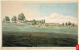
by Raja Kalyan Chand in 1563, when he laid the foundation of a town name 'Alam Nagar', which was also called, 'Rajapur' , a name that still used and has been found inscribed on a number of copper plates of the time .
Mughal historians mention that Chand ruler, Gyan Chand, visited Delhi Sultanate
Delhi Sultanate
The Delhi Sultanate is a term used to cover five short-lived, Delhi based kingdoms or sultanates, of Turkic origin in medieval India. The sultanates ruled from Delhi between 1206 and 1526, when the last was replaced by the Mughal dynasty...
and received the regions of Bhabhar
Bhabhar
Bhabhar is the region south of the Lower Himalayas and the Siwalik Hills It is the alluvial apron of sediments washed down from the Siwaliks along the northern edge of the Indo-Gangetic Plain.-Etymology:...
- Terai
Terai
The Terai is a belt of marshy grasslands, savannas, and forests located south of the outer foothills of the Himalaya, the Siwalik Hills, and north of the Indo-Gangetic Plain of the Ganges, Brahmaputra and their tributaries. The Terai belongs to the Terai-Duar savanna and grasslands ecoregion...
up to the Ganges as a grant from then Sultan. The lower hills remained under local chieftains; it was Kirti Chand (1488–1503), who first ruled the entire of Nainital district, along with the rest of Kumaon.
In 1581, the Chand King, Rudra Chand (1565–1597), son of Raja Kalyan Chand seized Sira defeating Raika king Hari Malla and attacked the Garhwal Kingdom
Garhwal Kingdom
Garhwal Kingdom was a princely state in north-western Uttarakhand, India, ruled by the Panwar dynasty. It was founded in 888 AD and existed until it was annexed by the Gorkhas in 1803...
for the first time, though this attack was repulsed by then king, Dularam Sah , and so were his subsequent attacks. Rudra Chandra was a contemporary of Akbar, and even paid him a visit in Lahore
Lahore
Lahore is the capital of the Pakistani province of Punjab and the second largest city in the country. With a rich and fabulous history dating back to over a thousand years ago, Lahore is no doubt Pakistan's cultural capital. One of the most densely populated cities in the world, Lahore remains a...
in 1587, as a mark of his obeisance. Akbarnama
Akbarnama
The ' , which literally means Book of Akbar, is the official chronicle of the reign of Akbar, the third Mughal Emperor , commissioned by Akbar himself and written in Persian by his court historian and biographer, Abul Fazl who was one of the nine jewels in Akbar's court...
mentions him as "one of the great landlords of India", and further talks about his initial hestitation in approaching the court of Akbqr, it was only Raja Todar Mal himself, sent his son Kalyan Das to assure him, did his proceed to meet Akbar. Subsequently, the two met and agreed on a concord , and thus Ain-e-Akbari, written during period of Akbar, also mentions the Sarkar of Kumaon, containing 21 Mahals (a geographical unit of the times) and the revenue collected .
After death of Rudra Chand in 1597, his son, Lakshmi Chand, also continued attacks of Garhwal for many years, though he too was repulsed. He also constructed the ‘Bagnath temple’ at Bageshwar
Bageshwar
Bageshwar is a city and a municipal board in Bageshwar district in the state of Uttarakhand, India. It is also the administrative headquarters of Bageshwar district....
in 1602.
Peak
One of most powerful rulers of Chand dynasty was Baz BahadurBaz Bahadur
Miyan Bayezid Baz Bahadur was the last sultan of Malwa, who reigned from 1555 to 1562. He succeeded his father, Shuja'at Khan. He is known for his romantic liaison with Roopmati, a singer of Rajput birth....
(1638–78) AD., who met Shahjahan in Delhi, and in 1655 joined forces with him to attack Garhwal, which was under its king, Pirthi Sah, and subsequently captured the Terai
Terai
The Terai is a belt of marshy grasslands, savannas, and forests located south of the outer foothills of the Himalaya, the Siwalik Hills, and north of the Indo-Gangetic Plain of the Ganges, Brahmaputra and their tributaries. The Terai belongs to the Terai-Duar savanna and grasslands ecoregion...
region including Dehradun
Dehradun
- Geography :The Dehradun district has various types of physical geography from Himalayan mountains to Plains. Raiwala is the lowest point at 315 meters above sea level, and the highest points are within the Tiuni hills, rising to 3700 m above sea level...
, which was hence separated from the Garhwal kingdom. Baz Bahadur extended his territory east to karnali river.
In 1672, Baz Bahadur, started a poll tax, and its revenue was sent to Delhi as a tribute. Baz Bahadur also built the Golu Devata
Golu Devata
Golu Devata or Lord Golu is the legendary mythological and historical God of the Kumaun region of Uttarakhand state of India and is their the much loved deity...
Temple, at Ghorakhal, near Bhimtal
Bhimtal
Bhimtal Lake is a lake in the town of Bhimtal, Uttarakhand, India. There is an island at the centre of the lake. It is the largest lake in the only real lake district of India...
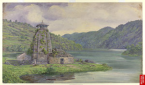
, after Lord Golu, a general in his army, who died valiantly at war . He also built famous Bhimeshwara Mahadev Temple at Bhimtal
Bhimtal
Bhimtal Lake is a lake in the town of Bhimtal, Uttarakhand, India. There is an island at the centre of the lake. It is the largest lake in the only real lake district of India...
.
Towards the end of 17th century, Chand Rajas again attacked Garhwal kingdom, and in 1688, Udyot Chand, erected several temples at Almora, including Tripur Sundari, Udyot Chandeshwer and Parbateshwer, to mark his victory over Garhwal and Doti, the Pabateshwar temple was renamed twice, to become the present Nanda Devi temple . Later, Jagat Chand (1708–20), defeated the Raja of Garhwal and pushed him away from Srinagar
Srinagar, Uttarakhand
For other uses, see Srinagar .Srinagar is the biggest town in garhwal and a municipal board in Pauri Garhwal District in the Indian state of Uttarakhand.-Geography:...
, and his kingdom was given to a Brahmin . However, a subsequent king of Garhwal, Pradip Shah (1717–72), regained control over Garhwal and retained Doon till 1757, when Rohilla
Rohilla
The Rohilla are a community of Hindi-speaking Pashtun also known as Pathan, historically found in the state of Uttar Pradesh, in North India. Most are now also found in Pakistan where they are now part of the Mohajir community. At one time, they form one of the largest Pashtun diaspora community...
leader, Najib-ul-Daula
Najib-ul-Daula
Najib-ud-daula, also known as Najib Khan, was a noted Rohilla tribal chief in 18th century Rohilkhand, who in the 1740s founded the city of Najibabad in Bijnor district, India, and succeeded Safdar Jang as Nawab Wazir of the Mughal Empire...
, established himself there, though he was ousted soon by Pradip Shah.
The Chand kings also defeated the Rajwar
Rajbar
Rajbhar or Rajwar was the title of the erstwhile medieval Kings of Askot in Pithoragarh district of the Kumaon region of the Uttarakhand state of India.-Origin:...
s of Askot
Askot
Askot or Askote is a small Himalayan town in Pithoragarh district of Uttarakhand in India. It is the part of Kanalichhina development Block and Didihat Tehsil....
, though the latter were allowed to hold their land on the payment of a tribute .
The hill station of Binsar, 30 km from Almora was summer retreat of the Chand kings .
In the coming years, Jagat Chand’s successor, Debi Chand (1720-6) took part in the wars of Rohilla
Rohilla
The Rohilla are a community of Hindi-speaking Pashtun also known as Pathan, historically found in the state of Uttar Pradesh, in North India. Most are now also found in Pakistan where they are now part of the Mohajir community. At one time, they form one of the largest Pashtun diaspora community...
s of Rohilkhand
Rohilkhand
Rohilkhand is a region of northwestern Uttar Pradesh state of India.Rohilkhand lies on the upper Ganges alluvial plain and has an area of about 25,000 km²/10,000 square miles...
, and was defeated by the British troops .
Decline
In 1744, Ali Mohammed KhanAli Mohammed Khan
Ali Muhammad Khan was a rohilla chief who founded the Pathan state of Rohilkhand in the northwestern region of the Uttar Pradesh state of India. He succeeded rohilla Sardar Daud Khan and helped develop Rohilkhand into a powerful nation, which became independent in 1721...
, the Rohilla leader, sent a force into the Chand territory and penetrated through Bhimtal
Bhimtal
Bhimtal Lake is a lake in the town of Bhimtal, Uttarakhand, India. There is an island at the centre of the lake. It is the largest lake in the only real lake district of India...
in the Nainital district to Almora
Almora
Almora is a municipal board, a cantonment town in the Almora district in the state of Uttarakhand, India. Almora was founded in 1568.It is a town bustling with activity and a rich cultural heritage and history. It is considered the cultural heart of the Kumaon region of...
; the resistance of Chand army, under its ruler, Kalyan Chand, was weak and ineffective, and Almora fell to the Rohillas, who stayed here for seven short months, though they were ultimately driven out, an exit made possible by paying them a sum of three lakh rupees, and hastened by the harsh terrain of the region.
This peace didn’t last long as after just three months, unhappy over his lieutenants, Ali Mohammed Khan
Ali Mohammed Khan
Ali Muhammad Khan was a rohilla chief who founded the Pathan state of Rohilkhand in the northwestern region of the Uttar Pradesh state of India. He succeeded rohilla Sardar Daud Khan and helped develop Rohilkhand into a powerful nation, which became independent in 1721...
attacked again, though this time, he was stopped right at the entrance to the hills, at Barakheri, and defeated; and he made no further attempts to conquer the Kumaon kingdom, nor did the Muslim rulers of Delhi, and this remained the first and the last attack by Muslim rulers on the region. Reconciliation subsequently came into effected; troops from the hills, under Dip Chand, fought side by side with the Rohillas at Third Battle of Panipat
Third battle of Panipat
The Third Battle of Panipat took place on 14 January 1761, at Panipat , about 60 miles north of Delhi between a northern expeditionary force of the Maratha Confederacy and a coalition of the King of Afghanistan, Ahmad Shah Abdali with 2 Indian Muslim allies—the Rohilla Afghans of the Doab, and the...
in 1761 .
In 1760, he renamed the old Parbateshwer temple as Dipchandeshwar temple
During British rule, then divisional commissioner of Kumaon, George William Trail, got the statue of the Nanda Devi, was relocated at ‘Udyot Chandeshwar’ temple, from the 'Malla Mahal' (Upper Court) of Chand kings, where present collectorate exists, and in time, the temple started being called the ‘Nanda Devi temple’. The 'Talla Mahal' (Lower Court) of Chand rulers, now houses the District Hospital .
Though due to internal strife, in the coming thirty years the kings lost most of the land they had previously ruled, in the plains, and retained only the Bhabhar
Bhabhar
Bhabhar is the region south of the Lower Himalayas and the Siwalik Hills It is the alluvial apron of sediments washed down from the Siwaliks along the northern edge of the Indo-Gangetic Plain.-Etymology:...
region.
In 1779, a subsequent Garhwal king, Lalit Shah, who also captured the Kumaon region from a usurper, who was then ruling Kumaon. Lalit Shah made his son Parduman Shah, the king of the Kumaon territory, and after a few years, on the death of his brother in Srinagar
Srinagar, Uttarakhand
For other uses, see Srinagar .Srinagar is the biggest town in garhwal and a municipal board in Pauri Garhwal District in the Indian state of Uttarakhand.-Geography:...
, Parduman Shah even held the seat of a combined kingdom of Kumaon and Garhwal for a year, before choosing to go back to Srinagar, in the familiar grounds of Garhwal.
In early 1790, the Gurkhas invaded the Kumaon hills and Almora, under their powerful chief ‘Prithvi Narayan’; they advanced by crossing River Kali, through Gangoli; and the Chands, under the titular Chand Raja, were driven to the Bhabhar
Bhabhar
Bhabhar is the region south of the Lower Himalayas and the Siwalik Hills It is the alluvial apron of sediments washed down from the Siwaliks along the northern edge of the Indo-Gangetic Plain.-Etymology:...
and finally expelled.
The Tarai and Kashipur were ceded to the British
United Kingdom
The United Kingdom of Great Britain and Northern IrelandIn the United Kingdom and Dependencies, other languages have been officially recognised as legitimate autochthonous languages under the European Charter for Regional or Minority Languages...
by the Nawab of Awadh
Nawab of Awadh
The Nawab of Awadh is the title of rulers who governed the state of Awadh in India in the 18th and 19th century. The Nawabs of Awadh originated form Persia-Establishment:...
in 1801, along with the rest of Rohilkhand
Rohilkhand
Rohilkhand is a region of northwestern Uttar Pradesh state of India.Rohilkhand lies on the upper Ganges alluvial plain and has an area of about 25,000 km²/10,000 square miles...
.
The Nepalese rule last for a ruthless twenty-four years, the end came because of their repeated intrusion into the British territories in the Tarai since early 1800, which Lord Moira
Francis Rawdon-Hastings, 1st Marquess of Hastings
Francis Edward Rawdon-Hastings, 1st Marquess of Hastings KG PC , styled The Honourable Francis Rawdon from birth until 1762 and as The Lord Rawdon between 1762 and 1783 and known as The Earl of Moira between 1793 and 1816, was an Irish-British politician and military officer who served as...
, the Governor-General of India
Governor-General of India
The Governor-General of India was the head of the British administration in India, and later, after Indian independence, the representative of the monarch and de facto head of state. The office was created in 1773, with the title of Governor-General of the Presidency of Fort William...
, deciding to attack Almora in December 1814, which marked the beginning of the Anglo-Nepalese War . After the war, the old Lal Mandi fort, near Almora (present cantonment), was renamed ‘Fort Moira’ .
Harak Deo Joshi, the minister of the last Chand Raja, took the side of the British, a force of 4500 men marched from Kashipur in February, 1815. Champawat was first taken in March from Pilibhit
Pilibhit
Pilibhit |Hafizabad]]) is a city and a municipal board in the Pilibhit district in the Indian state of Uttar Pradesh. Pilibhit is the north-eastern most district of Bareilly division, situated in the Rohilkhand region of the sub-Himalayan Plateau belt on the boundary of Nepal, known for the origin...
side through Kali river, and within two months, a strong British army under Colonel Nichols, attacked and captured Almora, on April 26, 1815,. Truce was called the same day, and with the ratification of Treaty of Sugauli
Sugauli Treaty
The Sugauli Treaty was signed on December 2, 1815 and ratified by March 4, 1816, between the British East India Company and Nepal, which was a kingdom during that era. This ended the second British invasion of the Himalayan kingdom during the Anglo-Nepalese War...
on 4 March 1816, Kumaon
Kumaon Division
For Kumaoni/Kumauni People see Kumauni PeopleKumaon or Kumaun is one of the two regions and administrative divisions of Uttarakhand, a mountainous state of northern India, the other being Garhwal. It includes the districts of Almora, Bageshwar, Champawat, Nainital, Pithoragarh, and Udham Singh Nagar...
and Garhwal
Garhwal Kingdom
Garhwal Kingdom was a princely state in north-western Uttarakhand, India, ruled by the Panwar dynasty. It was founded in 888 AD and existed until it was annexed by the Gorkhas in 1803...
, thus became a British
British Raj
British Raj was the British rule in the Indian subcontinent between 1858 and 1947; The term can also refer to the period of dominion...
territory.
Legacy
The first capital of Chand rulers, ChampawatChampawat
Champawat is a town and a nagar panchayat in Champawat district in the state of Uttarakhand, India. It is the administrative headquarters of Champawat district.-Mythology:...
, in the stronghold popularly known as Kali Kumaon, is now a district headquarter town, and hold many remnants of once powerful Chand reign, including a medieval fort, Baleshwar temple
Baleshwar Temple
Baleshwar Temple is ancient temple dedicated to Shiva, situated within city of Champawat in Uttarakhand.Built by the rulers of the Chand dynasty, Baleshwar Temple is a marvelous symbol of stone carving...
, Nagnath Temple, etc. Other temples of their reign are Golu Devata
Golu Devata
Golu Devata or Lord Golu is the legendary mythological and historical God of the Kumaun region of Uttarakhand state of India and is their the much loved deity...
Temple, at Ghorakhal, near Bhimtal
Bhimtal
Bhimtal Lake is a lake in the town of Bhimtal, Uttarakhand, India. There is an island at the centre of the lake. It is the largest lake in the only real lake district of India...
, and Bhimeshwara Mahadev Temple at Bhimtal
Bhimtal
Bhimtal Lake is a lake in the town of Bhimtal, Uttarakhand, India. There is an island at the centre of the lake. It is the largest lake in the only real lake district of India...
.
See also
- Kumauni peopleKumauni peopleKumauni or Kumaoni are people from Kumaon region of Uttarakhand, India.They include all those who speak the Kumaoni language or any of its numerous dialects, living in the Almora, Bageshwar, Champawat, Pithoragarh, Nainital,Bijnor,Udham Singh Nagar,Moradabad, districts of Uttarakhand,...
- KumaonKumaon DivisionFor Kumaoni/Kumauni People see Kumauni PeopleKumaon or Kumaun is one of the two regions and administrative divisions of Uttarakhand, a mountainous state of northern India, the other being Garhwal. It includes the districts of Almora, Bageshwar, Champawat, Nainital, Pithoragarh, and Udham Singh Nagar...
- K. C. Singh BabaK. C. Singh BabaK. C. Singh Baba is a member of the 14th Lok Sabha of India. He represents the Nainital constituency of Uttarakhand and is a member of the Indian National Congress political party....
Descendant of Chand Rulers
Further reading
- History of Kumaun : English version of "Kumaun ka itihas". by B. D. Pande. 1993. Almora, India: Shyam Prakashan : Shree Almora Book Depot.
- Source Materials of Kumauni History, by Nityananda Misra. Published by Shree Almora Book Depot, 1994. ISBN 8185865248.
- Administrative History of Uttarakhand (Kumaon and Garhwal), During the Rule of the East India Company, 1815-1857, by Ajay Arora. Published by Eastern Book Linkers, 1996. ISBN 8186339337.
- History of Uttaranchal, by Umachand Handa. Published by Indus Publishing, 2002. ISBN 8173871345. Excerpts