
Doti
Overview
Uttarakhand
Uttarakhand , formerly Uttaranchal, is a state in the northern part of India. It is often referred to as the Land of Gods due to the many holy Hindu temples and cities found throughout the state, some of which are among Hinduism's most spiritual and auspicious places of pilgrimage and worship...
in the west and Karnali
Ghaghara River
Karnali or Ghaghara is a perennial trans-boundary river originating on the Tibetan Plateau near Lake Mansarovar. It cuts through the Himalayas in Nepal and joins the Sarda River at Brahmaghat in India. Together they form the Ghaghra River, a major left bank tributary of the Ganges. With a length of...
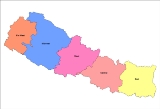
river on the east. Doti division covers the nine District of Seti and Mahakali Zone
Mahakali Zone
Mahakali|Kali River]] or Mahakali River, which originates from Kalapani.Mahakali's headquarter is Mahendranagar in Kanchanpur District. The zone covers the Himalayan range including Api Peak in the North, Hill valleys, Inner Terai valleys such as Patan in Baitadi District in the center and the...
, four in Mahakali and five in Seti Zone
Seti Zone
Seti ZoneSeti ZoneSeti ZoneSeti ZoneSeti ZoneSeti ZoneSeti ZoneSeti ZoneSeti Zone' onMouseout='HidePop("90926")' href="/topics/Darchula_District">Darchula District
, Baitadi District
, Dadeldhura District
, kanchanpur district, Doti District
, Kailali District
, Bajhang District
, Bajura District
and Achham District
.
Darchula District
Darchula District of 121,996.The town has an Indian counterpart to its northwest, named Dharchula. The split between the two towns is just virtual as the traditions, culture, and lifestyle of the people living across both the regions are quite similar....
, Baitadi District
Baitadi District
Baitadi district , historical name “Bairath” , a part of Mahakali zone, is one of the seventy-five districts of Nepal, a landlocked country of South Asia. The district, with Baitadi as its district headquarters, covers an area of 1,519 km² and has a population of 234,418. The Baitadi...
, Dadeldhura District
Dadeldhura District
Dadeldhura district, a part of Mahakali zone, is one of the seventy-five districts of Nepal, a landlocked country of South Asia. The district, with Dadeldhura as its district headquarters, covers an area of 1,538km² and has a population of 126,162....
, kanchanpur district, Doti District
Doti District
-History:Doti was a medieval kingdom of Nepal founded by Niranjan Malla Deo, the younger brother of Abhay Pal of Askot. Rulers of Doti were called 'Raika'...
, Kailali District
Kailali District
Kailali District of 616,697. Dhangadhi is a center of attraction of not only Kailali district but of the whole seti zone. The district also contains Tikapur Park, one of the biggest parks in Nepal, and Godha-Ghodi Tal lake.-Towns and villages:Baliya...
, Bajhang District
Bajhang District
-Towns and villages:Banjh,Bhairab Nath,Bhamchaur,Bhatekhola,Byasi,Chaudhari,Dahabagar,Dangaji,Dantola,Daulichaur,Deulekh,Deulikot,Dhamena,Gadaraya,Hemantabada,Kadal,Kailash,Kalukheti,Kanda,Kaphalaseri,Khiratadi,Koiralakot,Kot Bhairab,Kotdewal,...
, Bajura District
Bajura District
-Towns and villages:Atichaur,Baddhu,Wai,Barhabise,Bichhiya,Bramhatola,Budhiganga,Chhatara,Dahakot,Dogadi,Gotree,Gudukhati,Jagannath,Jayabageswori,Jugada,Kailashmandau,Kanda,Kolti,Kotila,Kuldeumadau,Manakot,Martadi,Pandusain,Rugin,Sappata,...
and Achham District
Achham District
Achham District,, a part of Seti Zone, is one of the seventy-five districts of Nepal, a landlocked country of South Asia. The district, with Mangalsen as its district headquarters, covers an area of 1,692 km² and has a population of 231,285. It is one of the remotest districts of Nepal...
.
Unanswered Questions