

Shannan Prefecture
Encyclopedia
The Shannan Prefecture (lit. "south of the mountains") also known as the Lhoka Prefecture ' onMouseout='HidePop("55219")' href="/topics/Pinyin">pinyin
: Shānnán Dìqū) is a prefecture in the southeastern area of the Tibet Autonomous Region
. The Shannan Prefecture
has the Gonggar County
, (alternatively "Gongkar", ; Chinese
: 贡嘎县; Pinyin
: Gònggá Xiàn) under its jurisdiction with the Gonggar Choide Monastery
, the Gonggar Dzong
, and the Gonggar Airport
near the Gonggar town. Located in the middle and lower stretches of the ancient Yarlung Valley
, formed by the Yarlung Zangbo River
, the Shannan Prefecture is known as the birth place of Tibetan Civilization. It is bounded by prefectures of Lhasa
on the north, Nyingchi
to the east, Xigaze on the west, and the International border with India
and Bhutan
on the south. The prefecture measures 420 kilometres (261 mi) east to west and 329 kilometres (204.4 mi) from north to south. Its uniqueness is because the first farmland, the first palace and the first Buddhist monastery of Tibet are all located in the prefecture. It also has the distinction of holding the first Tibetan opera. Ethnic Tibetans constitute 98% of the population and the balance 2 % comprise the ethnic groups of Han
, Hui
, Monba, Lhoba
and other nationalities. It has 12 counties and its capital is Tsetang
town, which is located 183 kilometres from Lhasa
.
The Shannan Prefecture covers an area of 79700 square kilometre, which includes South Tibet
, a disputed territory under the control of the India
n state of Arunachal Pradesh
. Its topography is spread over an average altitude of 3700 metres (12,139.1 ft). There are 14 ethnic groups, including Tibetans, the Han, the Menba, and the Luoba living in the area. The population of the city was 330,100 as of 2007 with Tibetans accounting for 96% of Shannan's total population. The prefecture has not only an ancient historical background but is also the most prosperous in Tibet.
and a field in the village of Sare near Tsetang
Town, is said to be the first farming field in Tibet. The first king in Tibetan history, Nyatri Tsenpo
, really a mere chief of the Yarlong tribe, began ruling over the Yarlung valley in the beginning of second century BC. He founded the Fan Kingdom and established a hereditary monarchy. During the reign of the ninth king, Budegong, agriculture flourished and he was able to mobilize the people to excavate canal, channelling water to irrigate the flatland. A formal forming system came into existence during the reign of Yixiulie, the eleventh king, when he devised standard measurement units for allocating farmland and counting livestock. Six palaces were built in the region between the rule of the ninth and fifteenth kings.
Around the 6th century AD, the Yarlung Valley became a slavery society, smelting iron, copper and silver to produce weapons and other objects. The 31st king of Yarlung, Langrilunzan, was an expansionist and invaded neighbouring tribes, expanding the territory of Yarlung. The 32nd king, Songtsän Gampo conquered Subi Tribe, Yangtong tribe and many others and established the Tubo Regime, or the Tibetan Empire
. Although transferred his capital city from Qiongjie to Lhasa
, many of his descendant of the royal lineage still lived in the Lhokha region. He made Yungbulakang Palace
his summer palace, which by this time was an important centre for Buddhism and the storage of Buddhist scriptures. In 641 AD, Gampo married Princess Wencheng of the Tang Dynasty
.
 During the Tubo Regime, a great number of irrigation projects developed along the Yarlong River and the Yarlung Tsangpo River, and with the increase of yaks and horses here there was dramatic development in agriculture. However, continued conflict led to endless famine and eventually the collapse of the Tubo regime. In 1253, Mengge, the emperor of Yuan Dynasty
, invaded Tibet and united the squabbling tribes into an administrative region, controlled by the central government of Yuan Dynasty in Beijing
. However, the dominant tribe in the Yarlung valley during this period was the Pazhu Dynasty and in 1322, Qiangqujianqun became the leader of the Pazhu and replenished agricultural activity in the region, funding irrigation works, cultivating lands, reconstructing roads, restoring houses and developing husbandry. Qiangqujiangqun founded the Naidong Dynasty which would last for 262 years, introduced the system of feudal serfdom
and implemented a new government system with divisions known as Zong, established 13 of them in Naidong (the capital), Gonggar and so forth.
On May 23 of 1951, Lhokha Prefecture, together with the other prefectures signed an agreement with the central government of the People’s Republic of China for the peaceful liberation of Tibet. However, in 1959, the Lhoka/Shannan Prefecture was annexed to China by brutal force and the feudal serfdom
system was abolished. Many monasteries were destroyed during the invasion and the Yungbulakang Palace was severely damaged.
 The Shannan Prefecture forms one-fifteenth of the total area of the Tibet Autonomous Region. It comprises 12 counties, out of which the eight northern counties are the Nedong, Qusum, Qonggyai, Sangri, Comai, Zenang, Gyacha and Cona in the middle valley of the Yarlung Zangbo, and the remaining four namely, the Gonggar, Lhunzi, Lohozhag and Nagarze are in the Himalayan belt. The Cona, Lhongzi, Nanggarze and Lhozha counties form the International Border. The prefecture's counties have 144 townships of which 71 townships are in agricultural sector, 18 are in animal husbandry sector and the balance 55 are a mix of the two sectors. There are also five neighbourhood committees and 719 village committees. The wide Yarlung River flowing from west to east (between Quxu and Gyacha) also known as Tsongpo and the Brahmaputra River
in India and Jamuna in Bangladesh
, and its tributaries flows through the middle and lower stretches of the prefecture and is bounded by Lhasa
on the north, Nyingchi Prefecture
on the east, Xigaze Prefecture
to the west and international border that extends to 630 kilometres (391.5 mi) with India and Bhutan. The river system has provided large perennial source of water in the region of fertile land. The valley created by the river system has very green pasture land and thick forests.
The region is studded with hills, valleys, rivers, streams, lakes, hot springs, limestone
(karst
) caves and many natural scenic regions. The region is also credited with the first “cultivated lands, measured fields, water irrigation, storing the forage grass, moulding metal, and many other techniques”.
The natural scenic regions of the prefecture have been categorized under four types. The Yarlung State Scenic Region is one type which has the snow covered mountains, glaciers, pastures, river valley, alpine vegetation and historical monuments and folk customs and art forms. It is the only one of its kind in Tibet. Shannan has natural beauty and a charming cultural heritage.
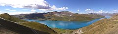
The prefecture has rich water resources of the Yarlung Zangbo or Tsongpo as it is known in the short form. It is the mother river of Tibet. In addition, 41 other rivers also flow through Shannan. The river flowing from west to east has a river area of 38300 square kilometre and flows for 424 kilometres (263.5 mi) through seven counties namely, Nanggarze, Gonggar, Chahang, Nedong, Sangri, Qusum and Gyacha. In addition, there are 88 lakes of which the important ones are the Yamdrok Lake
, the Chigu Lake and the Purmo Yumco lake. The hydroelectric power potential of the river system of Shannan has been assessed at 35.1 million kW. However, the power generated at present is only 18,300 kW.
Yamdrok Yumtso Lake, appears like jasper in a dark blue colour and it is one of the four holy lakes in Tibet. Viewed from the top of the Gampala Pass (4794 metres (15,728.3 ft)), the lake appears in the shape of a scorpion
. It is located in Nhagartse County on the way to Gyantse
and is 50 kilometres (31.1 mi) from Tsedang Yumtso. It is situated at an altitude of 4480 metres (14,698.2 ft) and has a very large area of 638 square kilometre, with a shoreline of 250 kilometres (155.3 mi). The average depth of water in the lake is about 30–40 m (98.4–131.2 ft) with deepest depth reported to be 60 metres (196.9 ft). There are many Tibetan fish species in the lake. Aqua fauna noted in the lake have been listed as wild duck, goose and many other species.
 Yamdrok Lake, also known as Yamḍok Yumtso, is one of the three largest sacred lake
s in Tibet and is over 72 kilometres (44.7 mi) long with an area of 638 square kilometre. The lake is fan-shaped, spreading to the south but narrowing up to the north. The mountainous lakeshore is highly crenellated, with numerous bays and inlets. Lake Yamdrok freezes in winter. Like mountains, lakes are considered sacred by Tibetan people, the principle being that they are the dwelling places of protective deities and therefore invested with special spiritual powers. It is the largest lake in southern Tibet and home to the famous Samding Monastery
which is on a peninsula jutting into the lake. Samding Monastery is where Dorje Pakmo, the only female Lama
in Tibet, stayed and presided, and stands to the south of Lake Yamdrok Yumtso.
Yamdrok Lake, has a power station
that was completed and dedicated in 1996 near the small village of Pai-Ti
at the lake’s western end. This power station is the largest in Tibet.
 The Holy Lake, also known as the Lhamo Latso, in Gyaca County
, is an alpine lake seen in the shape of horse’s hoof in the midst of mountains located at an elevation of 5100 metres (16,732.3 ft). It is glacier fed and has water surface area of about2 square kilometre. The lake is credited with miraculous potential for oracles or prognostication of events, particularly related to the succession process of the reincarnation of the Dalai Lama
s and Panchen Lama
s that is stated to get reflected in this Holy Lake. This vision is sought through elaborate Buddhist rites performed by high-ranking lamas. It is said that Palden Lhamo, as the female guardian spirit of the sacred lake, Lhamo La-tso, promised Gendun Drup, the First Dalai Lama in one of his visions "that she would protect the reincarnation lineage of the Dalai Lamas." Ever since the time of Gendun Gyatso, the Second Dalai Lama, who formalised the system, the Regents and other monks have gone to the lake to seek guidance on choosing the next reincarnation through visions while meditating there. It is also believed by pilgrims that they can see visionary images of their future by looking at the lake intently in silence with deep devotion and reverence and by performing Buddhist rites. The lake thus attracts a lot of pilgrims seeking signs of their future. The lake is said to be "The Life-Spirit-Lake of the Goddess", the goddess being Palden Lhamo
, the principal "Protectress" of Tibet. It was here that in 1935, the Regent, Reting Rinpoche
, received a clear vision of three Tibetan letters
and of a monastery with a jade-green and gold roof, and a house with turquoise
roof tiles, which led to the discovery of Tenzin Gyatso, the present 14th Dalai Lama
.
of the Zangmu Hydro Power Station, which will have an installed capacity of 510 MW. It is 140 kilometres (87 mi) from Lhasa and construction work is expected to start soon with financing provided by Huaneng, China's top power company and Gezhouba, a leading dam building company to build the project. The dam is being built at an altitude of 3260 metres (10,695.5 ft), and its height is 116 metres (380.6 ft) with a length of 390 metres (1,279.5 ft). This project will have serious implications for the downstream riparian countries of India and Bangladesh.
cause the precipitation in the region and results in a temperate climate. It has short cool summers with winters being long, dry and windy. There is a wide variation in temperature between day and night. The average temperature lies between 7.4–8.9 °C (45.3–48 F). The average annual precipitation reported varies from 300–400 mm (11.8–15.7 in) and 90% of this rainfall occurs during the monsoon months from June to September. The annual wind speed is 17 metres (55.8 ft)/sec and December to March are the windy months.
The forest area in the Shannan Prefecture is reported to be 1.55 million ha, which is 5% of the total forest cover in Tibet. The forest resource in terms of volume has been assessed as 38.8 billion cum. The forest has rich variety of plant species; 1000 species of trees, precious wood and herbal plants have been identified. Afforestation programmes have been pursued vigorously with the result that a forest belt of 25 kilometres (15.5 mi) stretch has been created in the Zetang City, on the bank of the Yarlung River which helps in erosion control due to wind and river action, and also enhances the beauty of the city. Thirty apple orchards set up in the prefecture produce 1,000 tonnes of fruit each year.
, are shown by the Chinese government to be Tibetan territory (although in the control of India) and hence marked disputed. The details of the names of the county, its transliterated names in Hanzi, Hanyu Pinyin, Wylie
, Tibetan
, population (as of 2003), area and density of population are given in the following table.
There are 14 ethnic groups, including Tibetans, the Han, the Menba, and the Luoba, living in the area.
Tourism is also an important sector contributing to the economy of the region. A Report of 2007 records a tourist footfall of 703,000. However, this sector is not fully open and is subject to the permit system controlled by many governmental agencies, and many areas are out of bounds for visitors as they are military zones or sensitive areas.
Agriculture
The prefecture had 450000 hectares (1,111,973.2 acre) of land (350000 hectares (864,868.1 acre) were irrigated, which was 77% of the cultivated area) under cultivation in 1999, producing 4725 kilograms (10,416.8 lb) of grain per hectare, which marked Shannan as an important commercial grain production centre in Tibet. Animal husbandry, another agrarian sector covered 2.2 million ha of posture land with all farmhouse holds involved in animal husbandry; there were 2.14 million heads of domestic animals (comprising 12 percent yaks, 10 percent cows, 50 percent sheep and goats 20 percent goats). Its agricultural tradition is traced to the ancient Yarlong tribes when the prefecture was known as "the grain store of Tibet".
The irrigated agricultural base of the prefecture is supported by a network of 1,312 canals, 141 wells with pumping stations with installed capacity of 2,398 kilowatts; 27 irrigation pumps with an installed capacity of 1,552 kilowatts, nine reservoirs with storage of 3.31 million cubic meters and 816 water ponds. Mechanised farming is widely practiced in Shannan Prefecture. This large extent of agriculture has resulted in increasing the per capita income of farmers and herders to 1000 yuan, a 7-fold increase over the average of 137 yuan in 1959. This has also resulted in rural prosperity and even creation of a rich farming community who have established the first "farmers hotel" in the region, and investing in real estate.
Mineral resources
The prefecture has more than 20 types of metal and non-metal mineral resources such as chromium, gold, copper, iron, antimony, lead, zinc, manganese, mica, crystal, jade and marble. Its proven reserve of chromium
is about 5 million tons, the highest in the country, which is about 35–45% of the China's total resources (in a total area of 2500 square kilometre). It is being extracted in the Norbusa Chromite Mine. Other natural resources relate to construction industry such as marble, granite, limestone and clay, which are also abundant in the prefecture.
Industries
The industrial sector in the prefecture, apart from service sector trading, are industries in the fields of electricity, mining, farm-implement and vehicle repairing, cement, metallurgy, printing, pharmaceuticals, food processing. Light industries for processing of agricultural and livestock products and pharmaceuticals are widely adopted by replacing manual operation with mechanization and semi-mechanization. However, most textiles and leather processing are yet to be mechanized.
Handicrafts
The ethnic handicrafts of the prefecture have a hoary history. This has generated many opportunities to develop the handicraft industry. The most significant handicrafts of the prefecture, which have world-wide market, are the commercial products of utility, religious use and artistic crafts of the royal families of Tibet of the past. These are: The pulu blanket, Minzholin Tibetan incense and knitted products (of Zhanang County), bagdion apron (of Gonggar County), bracelets, necklaces, incense burner of Qonggyai, carpets and butter bottles of Qusum, popular stone utensils of Zaga and Sangri, Cona handcrafted wooden bowls, butter tea Cup of Jiyayu, knife of Lhunzi (gilded with silver), Nagarze silver tea cup, jade ware of Quingje County and Tibetan quilt. Other famous consumer products are the butter of Lagong and dried meat of Yamzhog.
and the Lhamai Laco of Gyacha, which are considered as sacred; and religious places of worship such as the Do-rje-brag Monastery (also spelt Dorjezha Monastery), the Quamzhub Monastery which is under state control, the Samding Monastery, the Samyas Monastery (the first monastery built in Tibet), Quinpu Meditation Cave and the Zayang Zang Karst Cave. Some of the notable monuments and monasteries are in the National Heritage list.
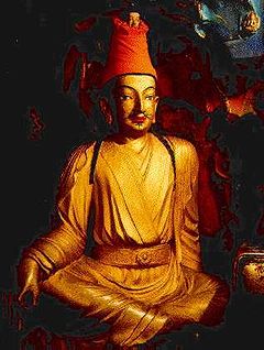
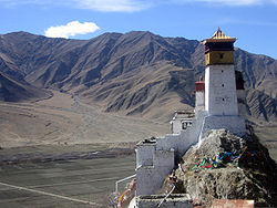 Yungbulakhang Palace was the earliest palace built in Tibet between 400 BC and 200 BC, during the reign of the first King Nyatri Tsanpo, in ancient Yarlung Valley
, in Nedong County
. It is 8 kilometres (5 mi) to the south of Zetang Town, the capital of the prefecture. It is stated to be “several ten metres high and its magnificent contour looks like a part of the cliff.” It is built like a fortress, on the apex of Mt. Tashitseri on the east bank of Yarlung River. The palace looks down over the entire beautiful Yarlung Valley. According to folk legend, the king Nyatri descended from heaven, as also the first Tibetan scriptures and few religious objects were set down here from the heaven, during the rule of the 28th King Lhatotorinyetsan. The palace walls are built in stone while the roof structure is made of earth and timber. It overlooks a farmland which is stated to be the “first farm land in Tibet.” The palace is approached through a series of steps built as a measure to defend the palace from enemy attack.
Zamasang palace
Zamasang Palace, a 8th century monument, now seen in ruins, was the palace of Tride Zotsan and Princess Jincheng. King Trison Detsan was born here. After Detsen’s death, the Bon
religious group of nobles who were opposed to Buddhism
propagated by Dretsen completely destroyed the palace. Now, only a small temple in honour of Tride Zotsan and Princess Jincheng with their statues deified inside, is seen among the ruins.
Namsailing Manor
Namsailing Manor built by Serf owners during the Ming Dynasty
is a cultural heritage under state protection. It is located in Channang Town, 25 kilometres (15.5 mi) from Zetang across the river, opposite to the Samye Monastery. It is a seven-storied structure accommodating flat houses, horse stables, a mill, a workshop for weaving and dyeing, a pillbox and a jail.
Samye monastery
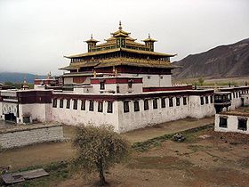 Samye Monastery was built in 763 AD under the direction of Guru Padmasambhava under the patronage of Tibetan king Trisong Detsan. It is located on the northern bank of the Yarlung Zambo River in Danang County. ‘Samye’ in Tibetan means “unexpected building.” The layout of the monastery is a replication of the Odantapuri
temple
in Bihar
, India, and represents the Buddhist cosmology
. It was the first monastery built in Tibet which has a studied transition of temple architecture and Tibetan architecture. The monastery consists of halls, residence for monks, stupas and colleges. This monastery was the first of its kind in Tibet, which resulted in a transition from the temple architectural style to the Tibetan monastery style in Tibet.
The Cosmic Buddhist design also known as “the universal model described in Buddhist scriptures” adopted for the architectural planning of the monastery has involved a central temple of a hall called the Uze Hall, a three storied structure representing Mt. Sumeru, the mythical mountain, built in three different architectural styles of Tibetan, Chinese Central Plain and Indian. Frescoes adorn the inner walls while Bhudda and other deities are enshrined in the main hall. The main hall has several smaller units which are termed as the Buddha hall, the sutra hall, circumambulation passage surrounding the hall, side halls and circular passages. It is surrounded by four temples which are known as the ling, representing the four continents amidst vast oceans to the north, south, east and west of Sumeru. The smaller temples flank the four temples to their right and left, which are known as the lingtren (meaning sub continents) making up the Buddhist Universe
. Two chapels for worship of Sun
and Moon
are part of this complex. The entire monastery is surrounded by a circular wall (fencing wall) which has many small stupas on the top; four large stupas are in four colours namely white, red, blue and green. When the monastery was built, 7 young men of the royal family resided in the monastery as monks, apart from ordained monks. In view of this combination of royal monks, the lamas and the Buddha deified in the monastery for worship it was given the rank as the first Tibetan Monastery. The monastery has exquisite stone carvings and paintings. It is said that the main statue first descended from heaven on the Mt. Hapori from where it was shifted to the monastery. The chapel has many yak
butter lamps which are carved in stone. Frescoes in the monastery depict folk athletics and dances. This monastery has been the forerunner of similar monasteries built in Tibet in the 10th century. The monastery has undergone refurbishing and additions several times during the reigns of the Sakya sect without altering the basic concept of its original plan. It was renovated recently in the 1980s with funds provided by the government.
Tradruk Monastery
Tradruk Temple, built in 641 AD in Tsedang, is one of the earliest Buddhist temples in Tibetan history. King Songtsan Gampo built this temple as a protection to his kingdom from the demoness or Ogresses. In later years, it was the winter palace of the King and Princess Wencheng. The temple has precious relics. The monastery also houses the Pear
Tangka, which is 2 metres (6.6 ft) in length and 1.2 metres (3.9 ft) in width and made of 29,026 pears studded with precious stones. The Thangka was painted by Naidong during the reign of Pamodrupa Kingdom.
Lhalong Monastery
Built in 1155, Lhalong Monastery is located at Monda
in Lhodrak County. It initially belonged to the Karma Sect but was later brought under Gelukpa Sect by the Fifth Dalai Lama, in the mid 17th century. The monastery also enjoyed the patronage of emperors of Qing Dynasty
. It became famous throughout Tibet for wrong reasons as in this monastery lama Lhalong Pekyi Dorje put an end to the Tubo Dynasty by murdering the last Tibetan king Langdarma
, the first ruler of unified Tibetan Empire
.
Dratang Monastery
Dratang Monastery was built in 1081 by Drapa Eshepa who was one of the 13 saints in Dranang County. Its allegiance is to the Sakyapa Sect, The monastery built on the pattern of the Somye Monastery has been substantially damaged, and now only walls on three sides remain (about 750 metres (2,460.6 ft)) and only one of the three floors is intact. It has some valuable frescoes.
Sekhargutok Monastery
Sekhargutok Monastery was built in 1080 AD It is located in Lhodrak County. It was built by the well-known Buddhist Guru Mharpa's disciple Milarepa
to atone for his sins. It is stated to be of unique architecture and contains rare Tibetan paintings.
Sange Choeling Monastery
The Sange Choeling Monastery, built in 1515 AD belongs to the Drupa Kang Yukpa Sect. It is spread over an area of3000 square metre. In the past, it had a vast estate extending from the Lhuntse Valley to Chabochu River.
Gyigag Monastery
Gyigag Monastery is a stop over point as part of the once in 12 years circumambulatory circuit of the holy mountains undertaken by Buddhist pilgrims.
Habori Mountain
Habori Mountain, once a haunted mountain was subdued to ensure trouble free construction of the Samye
Monastery. The devils were subdued by Guru Padmasambahva.
Nyimalung Holy Cave is where Guru Padmasambhva did meditation. There is small temple in front of the cave where the Guru and the Fifth Dalai Lama are said to have recited the Longevity Sutra.
Qingpo Mediation caves
Qingpo Mediation Caves are set at 3400 metres (11,154.9 ft) elevation, surrounded by Narui Mountains on three sides with Yarlung Zangbo River flowing to its south. Guru Padmasambhava and King Trison Detsan were learning and propagating Buddishm. Buddhist scriptures were buried here. The cave complex originally consisted of 108 meditation caves out of which 40 caves exist. In addition, also seen are 108 celestial burial chambers of eminent monks of Nyingma Sect and also rock paintings dated to the 14th century. It is located 15 kilometres (9.3 mi) to the northeast of Samye Monastery.
Zhayang Zong Lava cave
Zhayang Zong Lava Cave is in the Channang County amidst Zayangzong Mountain. There are three caves, two are exposed on the southern side and the third cave is interlinked. The largest cave, which has a Buddha hall and a Sutra hall, is 13 metres (42.7 ft) deep, 11 metres (36.1 ft) wide, 15 metres (49.2 ft) in height. The residential quarters of monks are located outside the cave. The second cave to the west of the large cave is where Padmasambhava lived while preaching Buddhism. This cave is interconnected with the bigger cave through a passage. The third cave is 10 metres (32.8 ft) wide and 55 metres (180.4 ft) deep. It has a collection of stones in different shapes and sizes.
and natural elements such as birds.
A colourful and widely celebrated festival is the Ongkor (Bumper Harvest) Festival which is observed in June according to the Tibetan calendar, in the riverine areas to mark good harvests of the season.
Festival of birds
The festival for worship of birds is called in Chinese ’yingniao jie.’ It is a religious festival that is special to the Bon
or Bonpo community, which still practices the original pre-Buddhist religion of Tibet known as Bön. During this festival, cuckoo
, the spring bird, which is considered the king of all birds arrives in the naidong qiasalakang temple in Tsedang, the Bird’s temple; according to a specific Tibetan calendar
date, corresponding to May as per Gregorian Calendar
. The festival is also observed in a different month at the Reting Monastery
and celebrated till the Cuckoo
is seen chirping and accepting food offerings in the monastery grounds. The bird temple has a large Buddha
statue cast by King Baikezan. On this occasion birds are given a red carpet welcome at Linka with a tribute of food items such as the Tibetan Highland barley, wheat, peas and other grains on a platter placed on a table. Two butter lamps are also lighted near the table. Two lamas are specially deputed from Lhasa to organise and perform this religious festival. The first cuckoo bird known locally as “Kuda” arrives as a messenger of the Cuckoo king of birds and after a survey of the arrangements made in the Linka, the chief Cuckoo bird arrives formally by performing “Xiezha” at the grounds where a table is set with offerings for the bird. Arrival of these spring birds every year and hearing its chirping is considered as an auspicious sign by the Tibetan people to usher a good cropping season; the birds have been the mascot
for Tibetan people since ancient times.
Shannan has a People's Hospital functioning since 1951, 195 medical and health centres with 747 hospital beds, a health and quarantine station with sub centres in the counties and the Health Care Hospital for Women and Children; the main hospitals have modern equipment such as fibre gastroscopy, B-type ultrasound diagnostic equipment, electrocardiogram
and electroencephalogram, x-ray machine
s and several other diagnostic and treatment tools.
Apart from modern medical facilities, the traditional Tibetan Medicinal practice has also been promoted in the prefecture and as a result a traditional Tibetan medicine hospital has been set up with 80 hospital beds. Tibetan medicines have been well received by people, with the Tibetan Hospital Pharmaceutical Factory in Shannan producing about 170 varieties of Tibetan medicines.
in Gyazuling town, which is 65 kilometres (40.4 mi) from Lhasa and which is known as the “air way door” to Tibet. The Lhasa airport has direct air links with Beijing
, Chengdu
, Shanghai
, Guangzhou
, Chongqing
, Xi'an
, and Kunming
. In addition, there are also international flights to Kathmandu, the capital city of Nepal
and also to Hong Kong
. It is 191 km from Lhasa. Regular buses operate from the two cities of Tsetang and Lhasa every day to the airport.
From the time Tibet Autonomous Region has been opened for other countries, development of many infrastructure and social sectors have recorded dramatic progress such as education, telecommunications and tourism.
The posts and telecommunications facilities first established in 1956 have now optical fiber
link between Zetang and Lhasa. As a result, program-controlled telephones, personal pagers, mobile telephones and other modern communication facilities are linked with the national network. Zetang also has landlines, microwave and satellite communications and postal delivery vehicles.
Pinyin
Pinyin is the official system to transcribe Chinese characters into the Roman alphabet in China, Malaysia, Singapore and Taiwan. It is also often used to teach Mandarin Chinese and spell Chinese names in foreign publications and used as an input method to enter Chinese characters into...
: Shānnán Dìqū) is a prefecture in the southeastern area of the Tibet Autonomous Region
Tibet Autonomous Region
The Tibet Autonomous Region , Tibet or Xizang for short, also called the Xizang Autonomous Region is a province-level autonomous region of the People's Republic of China , created in 1965....
. The Shannan Prefecture
Shannan Prefecture
The Shannan Prefecture also known as the Lhoka Prefecture is a prefecture in the southeastern area of the Tibet Autonomous Region...
has the Gonggar County
Gonggar County
Gonggar County, is a county of the Shannan Prefecture in the Tibet Autonomous Region, one of the 12 counties of the prefecture...
, (alternatively "Gongkar", ; Chinese
Chinese character
Chinese characters are logograms used in the writing of Chinese and Japanese , less frequently Korean , formerly Vietnamese , or other languages...
: 贡嘎县; Pinyin
Pinyin
Pinyin is the official system to transcribe Chinese characters into the Roman alphabet in China, Malaysia, Singapore and Taiwan. It is also often used to teach Mandarin Chinese and spell Chinese names in foreign publications and used as an input method to enter Chinese characters into...
: Gònggá Xiàn) under its jurisdiction with the Gonggar Choide Monastery
Gonggar Choide Monastery
The Gonggar Choide Monastery, also known as Gonkar Monastery, or Gonkar Dorjeden, in the Gonggar County of the Shannan Prefecture, in Tibet, is close to the Gonggar Dzong and the Gonggar Airport....
, the Gonggar Dzong
Gonggar Dzong
The Gonggar Dzong , also known as Gongkar Dzong, in the Shannan Prefecture with its capital city Tsedang in Gonggar County in Tibet, is close to the Gongkar town, the Gonggar Choide Monastery and the Gonggar Airport, from the town...
, and the Gonggar Airport
Lhasa Gonggar Airport
Lhasa Gonggar Airport is the airport serving Lhasa, the capital city of the Tibet Autonomous Region, China. It is located about southwest of the city in Gonggar County of Shannan Prefecture. The airport is close to the road to Tsetang, the capital of Shannan Prefecture.At an elevation of ,...
near the Gonggar town. Located in the middle and lower stretches of the ancient Yarlung Valley
Yarlung Valley
The Yarlung Valley is formed by the Yarlung River and refers especially to the district where it joins with the Chongye River, and broadens out into a large plain about 2 km wide, before they flow north into the Yarlung Zangbo River or Brahmaputra. It is situated in Nedong County of Lhokha...
, formed by the Yarlung Zangbo River
Yarlung Zangbo River
Yarlung River is a watercourse that originates upstream from the South Tibet Valley and Yarlung Zangbo Grand Canyon, in Tibet. It then passes through the state of Arunachal Pradesh, India, where it is known as the Dihang....
, the Shannan Prefecture is known as the birth place of Tibetan Civilization. It is bounded by prefectures of Lhasa
Lhasa
Lhasa is the administrative capital of the Tibet Autonomous Region in the People's Republic of China and the second most populous city on the Tibetan Plateau, after Xining. At an altitude of , Lhasa is one of the highest cities in the world...
on the north, Nyingchi
Nyingchi
Nyingchi may refer to:*Nyingchi Prefecture, prefecture in Tibet*Nyingchi County, county in Tibet...
to the east, Xigaze on the west, and the International border with India
India
India , officially the Republic of India , is a country in South Asia. It is the seventh-largest country by geographical area, the second-most populous country with over 1.2 billion people, and the most populous democracy in the world...
and Bhutan
Bhutan
Bhutan , officially the Kingdom of Bhutan, is a landlocked state in South Asia, located at the eastern end of the Himalayas and bordered to the south, east and west by the Republic of India and to the north by the People's Republic of China...
on the south. The prefecture measures 420 kilometres (261 mi) east to west and 329 kilometres (204.4 mi) from north to south. Its uniqueness is because the first farmland, the first palace and the first Buddhist monastery of Tibet are all located in the prefecture. It also has the distinction of holding the first Tibetan opera. Ethnic Tibetans constitute 98% of the population and the balance 2 % comprise the ethnic groups of Han
Han Chinese
Han Chinese are an ethnic group native to China and are the largest single ethnic group in the world.Han Chinese constitute about 92% of the population of the People's Republic of China , 98% of the population of the Republic of China , 78% of the population of Singapore, and about 20% of the...
, Hui
Hui people
The Hui people are an ethnic group in China, defined as Chinese speaking people descended from foreign Muslims. They are typically distinguished by their practice of Islam, however some also practice other religions, and many are direct descendants of Silk Road travelers.In modern People's...
, Monba, Lhoba
Lhoba
Lhoba is a term of obscure origin which has come to apply to a diverse amalgamation of Tibeto-Burman tribespeople living in and around "Pemako" , including Mainling, Medog, Zayü counties of Nyingchi Prefecture and Lhünzê County of Shannan Prefecture...
and other nationalities. It has 12 counties and its capital is Tsetang
Tsetang
Zêtang is one of the largest cities in Tibet and is located in the Yarlung Valley, 183 km southeast of Lhasa in Nedong County of Lhoka Prefecture, Tibet Autonomous Region of China...
town, which is located 183 kilometres from Lhasa
Lhasa
Lhasa is the administrative capital of the Tibet Autonomous Region in the People's Republic of China and the second most populous city on the Tibetan Plateau, after Xining. At an altitude of , Lhasa is one of the highest cities in the world...
.
The Shannan Prefecture covers an area of 79700 square kilometre, which includes South Tibet
South Tibet
The Arunachal Pradesh dispute is a territorial dispute over the region located on the middle of the Yarlung Zangbo River, 300 km north of the Himalayas. It is entirely administered by India as part of its Arunachal Pradesh state; China claims it as a part of its Tibet Autonomous Region and...
, a disputed territory under the control of the India
India
India , officially the Republic of India , is a country in South Asia. It is the seventh-largest country by geographical area, the second-most populous country with over 1.2 billion people, and the most populous democracy in the world...
n state of Arunachal Pradesh
Arunachal Pradesh
Arunachal Pradesh is a state of India, located in the far northeast. It borders the states of Assam and Nagaland to the south, and shares international borders with Burma in the east, Bhutan in the west, and the People's Republic of China in the north. The majority of the territory is claimed by...
. Its topography is spread over an average altitude of 3700 metres (12,139.1 ft). There are 14 ethnic groups, including Tibetans, the Han, the Menba, and the Luoba living in the area. The population of the city was 330,100 as of 2007 with Tibetans accounting for 96% of Shannan's total population. The prefecture has not only an ancient historical background but is also the most prosperous in Tibet.
History
A legend that attests to the position of Shannan Prefecture in the annals of Tibetan history states that the human beings are the creation of union between a sacred monkey and women. According to archaeological findings and legends and ancient documents, people lived in this area up to four million years ago. A primitive civilization grew up in the Yarlung ValleyYarlung Valley
The Yarlung Valley is formed by the Yarlung River and refers especially to the district where it joins with the Chongye River, and broadens out into a large plain about 2 km wide, before they flow north into the Yarlung Zangbo River or Brahmaputra. It is situated in Nedong County of Lhokha...
and a field in the village of Sare near Tsetang
Tsetang
Zêtang is one of the largest cities in Tibet and is located in the Yarlung Valley, 183 km southeast of Lhasa in Nedong County of Lhoka Prefecture, Tibet Autonomous Region of China...
Town, is said to be the first farming field in Tibet. The first king in Tibetan history, Nyatri Tsenpo
Nyatri Tsenpo
Nyatri Tsenpo was a king of Tibet from the so-called "Yarlung dynasty". His reign is said to have begun in 127 BC. According to traditional Tibetan history, he was the first ruler of the kingdom. He is said to have descended from heaven on Yalashangbo, the sacred mountain...
, really a mere chief of the Yarlong tribe, began ruling over the Yarlung valley in the beginning of second century BC. He founded the Fan Kingdom and established a hereditary monarchy. During the reign of the ninth king, Budegong, agriculture flourished and he was able to mobilize the people to excavate canal, channelling water to irrigate the flatland. A formal forming system came into existence during the reign of Yixiulie, the eleventh king, when he devised standard measurement units for allocating farmland and counting livestock. Six palaces were built in the region between the rule of the ninth and fifteenth kings.
Around the 6th century AD, the Yarlung Valley became a slavery society, smelting iron, copper and silver to produce weapons and other objects. The 31st king of Yarlung, Langrilunzan, was an expansionist and invaded neighbouring tribes, expanding the territory of Yarlung. The 32nd king, Songtsän Gampo conquered Subi Tribe, Yangtong tribe and many others and established the Tubo Regime, or the Tibetan Empire
Tibetan Empire
The historic name for the Tibetan Empire is different from Tibet's present name.Traditional Tibetan history preserves a lengthy list of rulers, whose exploits become subject to external verification in the Chinese histories by the seventh century. From the 7th to the 11th century a series of...
. Although transferred his capital city from Qiongjie to Lhasa
Lhasa
Lhasa is the administrative capital of the Tibet Autonomous Region in the People's Republic of China and the second most populous city on the Tibetan Plateau, after Xining. At an altitude of , Lhasa is one of the highest cities in the world...
, many of his descendant of the royal lineage still lived in the Lhokha region. He made Yungbulakang Palace
Yungbulakang Palace
Yumbulagang is an ancient palace in the Yarlung Valley, Nêdong County in the vicinity of Zêtang the seat of the prefectural administration of Lhoka , in the South of Tibet Autonomous Region of the People's Republic of China....
his summer palace, which by this time was an important centre for Buddhism and the storage of Buddhist scriptures. In 641 AD, Gampo married Princess Wencheng of the Tang Dynasty
Tang Dynasty
The Tang Dynasty was an imperial dynasty of China preceded by the Sui Dynasty and followed by the Five Dynasties and Ten Kingdoms Period. It was founded by the Li family, who seized power during the decline and collapse of the Sui Empire...
.
Yuan Dynasty
The Yuan Dynasty , or Great Yuan Empire was a ruling dynasty founded by the Mongol leader Kublai Khan, who ruled most of present-day China, all of modern Mongolia and its surrounding areas, lasting officially from 1271 to 1368. It is considered both as a division of the Mongol Empire and as an...
, invaded Tibet and united the squabbling tribes into an administrative region, controlled by the central government of Yuan Dynasty in Beijing
Beijing
Beijing , also known as Peking , is the capital of the People's Republic of China and one of the most populous cities in the world, with a population of 19,612,368 as of 2010. The city is the country's political, cultural, and educational center, and home to the headquarters for most of China's...
. However, the dominant tribe in the Yarlung valley during this period was the Pazhu Dynasty and in 1322, Qiangqujianqun became the leader of the Pazhu and replenished agricultural activity in the region, funding irrigation works, cultivating lands, reconstructing roads, restoring houses and developing husbandry. Qiangqujiangqun founded the Naidong Dynasty which would last for 262 years, introduced the system of feudal serfdom
Serfdom
Serfdom is the status of peasants under feudalism, specifically relating to Manorialism. It was a condition of bondage or modified slavery which developed primarily during the High Middle Ages in Europe and lasted to the mid-19th century...
and implemented a new government system with divisions known as Zong, established 13 of them in Naidong (the capital), Gonggar and so forth.
On May 23 of 1951, Lhokha Prefecture, together with the other prefectures signed an agreement with the central government of the People’s Republic of China for the peaceful liberation of Tibet. However, in 1959, the Lhoka/Shannan Prefecture was annexed to China by brutal force and the feudal serfdom
Serfdom
Serfdom is the status of peasants under feudalism, specifically relating to Manorialism. It was a condition of bondage or modified slavery which developed primarily during the High Middle Ages in Europe and lasted to the mid-19th century...
system was abolished. Many monasteries were destroyed during the invasion and the Yungbulakang Palace was severely damaged.
Geography
Brahmaputra River
The Brahmaputra , also called Tsangpo-Brahmaputra, is a trans-boundary river and one of the major rivers of Asia. It is the only Indian river that is attributed the masculine gender and thus referred to as a in Indo-Aryan languages and languages with Indo-Aryan influence...
in India and Jamuna in Bangladesh
Bangladesh
Bangladesh , officially the People's Republic of Bangladesh is a sovereign state located in South Asia. It is bordered by India on all sides except for a small border with Burma to the far southeast and by the Bay of Bengal to the south...
, and its tributaries flows through the middle and lower stretches of the prefecture and is bounded by Lhasa
Lhasa
Lhasa is the administrative capital of the Tibet Autonomous Region in the People's Republic of China and the second most populous city on the Tibetan Plateau, after Xining. At an altitude of , Lhasa is one of the highest cities in the world...
on the north, Nyingchi Prefecture
Nyingchi Prefecture
Nyingchi Prefecture is a prefecture in southwestern Tibet Autonomous Region in western China. The Chinese government claims South Tibet, which is currently governed by India, as part of the prefecture....
on the east, Xigaze Prefecture
Xigazê Prefecture
Xigazê is a prefecture of Tibet Autonomous Region in China.The administrative center of the prefecture is the city of Shigatse ....
to the west and international border that extends to 630 kilometres (391.5 mi) with India and Bhutan. The river system has provided large perennial source of water in the region of fertile land. The valley created by the river system has very green pasture land and thick forests.
The region is studded with hills, valleys, rivers, streams, lakes, hot springs, limestone
Limestone
Limestone is a sedimentary rock composed largely of the minerals calcite and aragonite, which are different crystal forms of calcium carbonate . Many limestones are composed from skeletal fragments of marine organisms such as coral or foraminifera....
(karst
KARST
Kilometer-square Area Radio Synthesis Telescope is a Chinese telescope project to which FAST is a forerunner. KARST is a set of large spherical reflectors on karst landforms, which are bowlshaped limestone sinkholes named after the Kras region in Slovenia and Northern Italy. It will consist of...
) caves and many natural scenic regions. The region is also credited with the first “cultivated lands, measured fields, water irrigation, storing the forage grass, moulding metal, and many other techniques”.
The natural scenic regions of the prefecture have been categorized under four types. The Yarlung State Scenic Region is one type which has the snow covered mountains, glaciers, pastures, river valley, alpine vegetation and historical monuments and folk customs and art forms. It is the only one of its kind in Tibet. Shannan has natural beauty and a charming cultural heritage.
Hydrology
This river area is spread over parts of eight counties of Shannan. Yamzog Yumcog Scenic Region which has lakes, snow covered mountains, islands, pasture land, hot springs, monasteries and many scenic places, Samyai Scenic Region which has many historical monuments in the counties of Samyi, Songa and Azar towns in the Zanang County and Sacred Lake Scenic Region which is covered by the Sangri, Qusum and Gyacha Counties, are part of this valley. The region has mountains, valleys, rivers, springs, historical architectural monuments and monasteries.The prefecture has rich water resources of the Yarlung Zangbo or Tsongpo as it is known in the short form. It is the mother river of Tibet. In addition, 41 other rivers also flow through Shannan. The river flowing from west to east has a river area of 38300 square kilometre and flows for 424 kilometres (263.5 mi) through seven counties namely, Nanggarze, Gonggar, Chahang, Nedong, Sangri, Qusum and Gyacha. In addition, there are 88 lakes of which the important ones are the Yamdrok Lake
Yamdrok Lake
Yamdrok Lake is one of the three largest sacred lakes in Tibet . It is over long. The lake is surrounded by many snow-capped mountains and is fed by numerous small streams. The lake does have an outlet stream at its far western end....
, the Chigu Lake and the Purmo Yumco lake. The hydroelectric power potential of the river system of Shannan has been assessed at 35.1 million kW. However, the power generated at present is only 18,300 kW.
Yamdrok Yumtso Lake
Yamdrok Yumtso Lake, appears like jasper in a dark blue colour and it is one of the four holy lakes in Tibet. Viewed from the top of the Gampala Pass (4794 metres (15,728.3 ft)), the lake appears in the shape of a scorpion
Scorpion
Scorpions are predatory arthropod animals of the order Scorpiones within the class Arachnida. They have eight legs and are easily recognized by the pair of grasping claws and the narrow, segmented tail, often carried in a characteristic forward curve over the back, ending with a venomous stinger...
. It is located in Nhagartse County on the way to Gyantse
Gyantse
Gyantse is a town located in Gyangzê County, Shigatse Prefecture. It was historically considered the third largest and most prominent town in the Tibet region , but there are now at least ten larger Tibetan cities.-Location:The town is strategically located in the Nyang River Valley on the ancient...
and is 50 kilometres (31.1 mi) from Tsedang Yumtso. It is situated at an altitude of 4480 metres (14,698.2 ft) and has a very large area of 638 square kilometre, with a shoreline of 250 kilometres (155.3 mi). The average depth of water in the lake is about 30–40 m (98.4–131.2 ft) with deepest depth reported to be 60 metres (196.9 ft). There are many Tibetan fish species in the lake. Aqua fauna noted in the lake have been listed as wild duck, goose and many other species.
Lake
A lake is a body of relatively still fresh or salt water of considerable size, localized in a basin, that is surrounded by land. Lakes are inland and not part of the ocean and therefore are distinct from lagoons, and are larger and deeper than ponds. Lakes can be contrasted with rivers or streams,...
s in Tibet and is over 72 kilometres (44.7 mi) long with an area of 638 square kilometre. The lake is fan-shaped, spreading to the south but narrowing up to the north. The mountainous lakeshore is highly crenellated, with numerous bays and inlets. Lake Yamdrok freezes in winter. Like mountains, lakes are considered sacred by Tibetan people, the principle being that they are the dwelling places of protective deities and therefore invested with special spiritual powers. It is the largest lake in southern Tibet and home to the famous Samding Monastery
Samding Monastery
Samding Monastery, Samten Ling, or Samding Goinba Samding, a Geluk Ani gompa - which also housed some monks - was built on a hill on a peninsula jutting into the sacred lake, Yar-'brog or Yamdrok Tso, about east of Nangkatse, and some southwest of Lhasa, at an altitude of 4,423 m or...
which is on a peninsula jutting into the lake. Samding Monastery is where Dorje Pakmo, the only female Lama
Lama
Lama is a title for a Tibetan teacher of the Dharma. The name is similar to the Sanskrit term guru .Historically, the term was used for venerated spiritual masters or heads of monasteries...
in Tibet, stayed and presided, and stands to the south of Lake Yamdrok Yumtso.
Yamdrok Lake, has a power station
Power station
A power station is an industrial facility for the generation of electric energy....
that was completed and dedicated in 1996 near the small village of Pai-Ti
Pai-Ti (village)
Pai-Ti is a small village located at the western end of Yamdrok Lake, in the Lhoka Prefecture. Near the village, the largest power station in Tibet was completed and dedicated in 1996.-Notes:...
at the lake’s western end. This power station is the largest in Tibet.
The Holy Lake
Gyaca County
Gyaca County, is a county of the Shannan Prefecture located in the south-east of the Tibet Autonomous Region.Gyatsa County is in the south of Tibet, stretching from the Podrang La pass along the southern side of the Brahmaputra River downstream to Pamda which is just to the southwest of Daklha...
, is an alpine lake seen in the shape of horse’s hoof in the midst of mountains located at an elevation of 5100 metres (16,732.3 ft). It is glacier fed and has water surface area of about2 square kilometre. The lake is credited with miraculous potential for oracles or prognostication of events, particularly related to the succession process of the reincarnation of the Dalai Lama
Dalai Lama
The Dalai Lama is a high lama in the Gelug or "Yellow Hat" branch of Tibetan Buddhism. The name is a combination of the Mongolian word далай meaning "Ocean" and the Tibetan word bla-ma meaning "teacher"...
s and Panchen Lama
Panchen Lama
The Panchen Lama , or Bainqên Erdê'ni , is the highest ranking Lama after the Dalai Lama in the Gelugpa lineage of Tibetan Buddhism...
s that is stated to get reflected in this Holy Lake. This vision is sought through elaborate Buddhist rites performed by high-ranking lamas. It is said that Palden Lhamo, as the female guardian spirit of the sacred lake, Lhamo La-tso, promised Gendun Drup, the First Dalai Lama in one of his visions "that she would protect the reincarnation lineage of the Dalai Lamas." Ever since the time of Gendun Gyatso, the Second Dalai Lama, who formalised the system, the Regents and other monks have gone to the lake to seek guidance on choosing the next reincarnation through visions while meditating there. It is also believed by pilgrims that they can see visionary images of their future by looking at the lake intently in silence with deep devotion and reverence and by performing Buddhist rites. The lake thus attracts a lot of pilgrims seeking signs of their future. The lake is said to be "The Life-Spirit-Lake of the Goddess", the goddess being Palden Lhamo
Palden Lhamo
Palden Lhamo , Palden Lamo , Shri Devi , or Ukin Tengri is a protecting Dharmapala of the teachings of Gautama Buddha in the Gelug school of Tibetan Buddhism. She is also called Remati...
, the principal "Protectress" of Tibet. It was here that in 1935, the Regent, Reting Rinpoche
Reting Rinpoche
Reting Rinpoche is the title held by abbots of Reting Monastery, a Buddhist monastery in central Tibet. The identity of the present Reting Rinpoche is contested.-History of the lineage:...
, received a clear vision of three Tibetan letters
Tibetan script
The Tibetan alphabet is an abugida of Indic origin used to write the Tibetan language as well as the Dzongkha language, Denzongkha, Ladakhi language and sometimes the Balti language. The printed form of the alphabet is called uchen script while the hand-written cursive form used in everyday...
and of a monastery with a jade-green and gold roof, and a house with turquoise
Turquoise
Turquoise is an opaque, blue-to-green mineral that is a hydrous phosphate of copper and aluminium, with the chemical formula CuAl648·4. It is rare and valuable in finer grades and has been prized as a gem and ornamental stone for thousands of years owing to its unique hue...
roof tiles, which led to the discovery of Tenzin Gyatso, the present 14th Dalai Lama
14th Dalai Lama
The 14th Dalai Lama is the 14th and current Dalai Lama. Dalai Lamas are the most influential figures in the Gelugpa lineage of Tibetan Buddhism, although the 14th has consolidated control over the other lineages in recent years...
.
Tsangpo River
The Tsangpo River, till recently untapped with no storage dams across it, has been planned to be developed with a cascade of five dams on the main stem of the river in its middle reaches; the five dams proposed are the Zangmu, the Gyatsa, the Zhongda, the Jiexu and the Langzhen. The first project in the cascade is the Zangmu DamZangmu Dam
The Zangmu Dam is a gravity dam currently under construction on the Brahmaputra River northwest of Gyaca in the Tibet Autonomous Region of China. The purpose of the dam is hydroelectric power production using run-of-the-river technology. The dam is part of the Zangmu Hydropower Project and will...
of the Zangmu Hydro Power Station, which will have an installed capacity of 510 MW. It is 140 kilometres (87 mi) from Lhasa and construction work is expected to start soon with financing provided by Huaneng, China's top power company and Gezhouba, a leading dam building company to build the project. The dam is being built at an altitude of 3260 metres (10,695.5 ft), and its height is 116 metres (380.6 ft) with a length of 390 metres (1,279.5 ft). This project will have serious implications for the downstream riparian countries of India and Bangladesh.
Climate and vegetation
The Himalayas in the north and the Grandise mountains in the south dictate the climatic conditions in the prefecture. The warm and moisture laden winds from the Indian OceanIndian Ocean
The Indian Ocean is the third largest of the world's oceanic divisions, covering approximately 20% of the water on the Earth's surface. It is bounded on the north by the Indian Subcontinent and Arabian Peninsula ; on the west by eastern Africa; on the east by Indochina, the Sunda Islands, and...
cause the precipitation in the region and results in a temperate climate. It has short cool summers with winters being long, dry and windy. There is a wide variation in temperature between day and night. The average temperature lies between 7.4–8.9 °C (45.3–48 F). The average annual precipitation reported varies from 300–400 mm (11.8–15.7 in) and 90% of this rainfall occurs during the monsoon months from June to September. The annual wind speed is 17 metres (55.8 ft)/sec and December to March are the windy months.
The forest area in the Shannan Prefecture is reported to be 1.55 million ha, which is 5% of the total forest cover in Tibet. The forest resource in terms of volume has been assessed as 38.8 billion cum. The forest has rich variety of plant species; 1000 species of trees, precious wood and herbal plants have been identified. Afforestation programmes have been pursued vigorously with the result that a forest belt of 25 kilometres (15.5 mi) stretch has been created in the Zetang City, on the bank of the Yarlung River which helps in erosion control due to wind and river action, and also enhances the beauty of the city. Thirty apple orchards set up in the prefecture produce 1,000 tonnes of fruit each year.
Administrative sub-divisions
The Shannan Prefecture is marked by China with a geographical area of 79700 square kilometre distributed over 12 counties with a total population of 330,000. However, a large part of the counties of Lhünzê (隆子县) and Cona (错那县), covering an area of 28700 square kilometre and collectively known as South TibetSouth Tibet
The Arunachal Pradesh dispute is a territorial dispute over the region located on the middle of the Yarlung Zangbo River, 300 km north of the Himalayas. It is entirely administered by India as part of its Arunachal Pradesh state; China claims it as a part of its Tibet Autonomous Region and...
, are shown by the Chinese government to be Tibetan territory (although in the control of India) and hence marked disputed. The details of the names of the county, its transliterated names in Hanzi, Hanyu Pinyin, Wylie
Wylie transliteration
The Wylie transliteration scheme is a method for transliterating Tibetan script using only the letters available on a typical English language typewriter. It bears the name of Turrell V. Wylie, who described the scheme in an article, A Standard System of Tibetan Transcription, published in 1959...
, Tibetan
Tibetan language
The Tibetan languages are a cluster of mutually-unintelligible Tibeto-Burman languages spoken primarily by Tibetan peoples who live across a wide area of eastern Central Asia bordering the Indian subcontinent, including the Tibetan Plateau and the northern Indian subcontinent in Baltistan, Ladakh,...
, population (as of 2003), area and density of population are given in the following table.
| # | Name | Hanzi | Hanyu Pinyin | Tibetan Tibetan language The Tibetan languages are a cluster of mutually-unintelligible Tibeto-Burman languages spoken primarily by Tibetan peoples who live across a wide area of eastern Central Asia bordering the Indian subcontinent, including the Tibetan Plateau and the northern Indian subcontinent in Baltistan, Ladakh,... |
Wylie Wylie transliteration The Wylie transliteration scheme is a method for transliterating Tibetan script using only the letters available on a typical English language typewriter. It bears the name of Turrell V. Wylie, who described the scheme in an article, A Standard System of Tibetan Transcription, published in 1959... |
Population (2003 est.) | Area (km²) | Density (/km²) |
|---|---|---|---|---|---|---|---|---|
| 1 | Nêdong County Nêdong County Nêdong County, is a county of the Shannan Prefecture in the Tibet Autonomous Region.... |
乃东县 | Nǎidōng Xiàn | སྣེ་གདོང་རྫོང་ | sne gdong rdzong | 60,000 | 2,211 | 46 |
| 2 | Zhanang County Zhanang County Zhanang County, is a county of the Shannan Prefecture in the Tibet Autonomous Region,As of 2000 it had a population of 35,278.-Demographics:... |
扎囊县 | Zhānáng Xiàn | གྲ་ནང་རྫོང་ | gra nang rdzong | 40,000 | 2,157 | 19 |
| 3 | Gonggar County Gonggar County Gonggar County, is a county of the Shannan Prefecture in the Tibet Autonomous Region, one of the 12 counties of the prefecture... |
贡嘎县 | Gònggā Xiàn | འཕྱོངས་རྒྱས་རྫོང་ | gong dkar rdzong | 50,000 | 2,283 | 21 |
| 4 | Sangri County Sangri County Sangri County, is a county of the Shannan Prefecture in the Tibet Autonomous Region.... |
桑日县 | Sāngrì Xiàn | ཟངས་རི་རྫོང་ | zangs ri rdzong | 20,000 | 2,634 | 8 |
| 5 | Qonggyai County Qonggyai County Qonggyai County or Chongye County, is a county of the Shannan Prefecture in the Tibet Autonomous Region.-History:... |
琼结县 | Qióngjié Xiàn | འཕྱོངས་རྒྱས་རྫོང་ | 'phyongs rgyas rdzong | 20,000 | 1,030 | 19 |
| 6 | Qusum County Qusum County Qusum County, is a county of the Shannan Prefecture in the Tibet Autonomous Region.In 1999 the county had a population of 15,541 inhabitants. The capital is Qusum.... |
曲松县 | Qūsōng Xiàn | ཆུ་གསུམ་རྫོང་ | chu gsum rdzong | 20,000 | 1,936 | 10 |
| 7 | Comai County Comai County Comai County is a county of the Shannan Prefecture located in the south-east of the Tibet Autonomous Region,Comai County is famous for its Tibetan Mastiffs and known as the home of Tibetan Mastiff.... |
措美县 | Cuòměi Xiàn | མཚོ་སམད་རྫོང་ | mtsho smad rdzong | 10,000 | 4,530 | 2 |
| 8 | Lhozhag County Lhozhag County Lhozhag County, is a county of the Shannan Prefecture located in the south-east of the Tibet Autonomous Region,... |
洛扎县 | Luòzhā Xiàn | ལྷོ་བྲག་རྫོང་ | lho brag rdzong | 20,000 | 5,570 | 4 |
| 9 | Gyaca County Gyaca County Gyaca County, is a county of the Shannan Prefecture located in the south-east of the Tibet Autonomous Region.Gyatsa County is in the south of Tibet, stretching from the Podrang La pass along the southern side of the Brahmaputra River downstream to Pamda which is just to the southwest of Daklha... |
加查县 | Jiāchá Xiàn | རྒྱ་ཚ་རྫོང་ | rgya tsha rdzong | 20,000 | 4,493 | 5 |
| 10 | Lhünzê County Lhünzê County Lhünzê County, is a county of the Shannan Prefecture located in the south-east of the Tibet Autonomous Region,-Settlements:*Sangngagqoiling*Yümai... |
隆子县 | Lóngzǐ Xiàn | ལྷུན་རྩེ་རྫོང་ | lhun rtse rdzong | 30,000 | 9,809 | 3 |
| 11 | Cona County | 错那县 | Cuònà Xiàn | མཚོ་སྣ་རྫོང་ | mtsho sna rdzong | 10,000 | 34,979 | 0 |
| 12 | Nagarzê County Nagarzê County Nagarzê County is a county of the Shannan Prefecture located in the south-east of the Tibet Autonomous Region. The Yarlung Tsangpo river dominates the county.-Settlements:*Kaba*Karreg*Nagarzê *Zuidui... |
浪卡子县 | Làngkǎzǐ Xiàn | སྣ་དཀར་རྩེ་རྫོང་ | sna dkar rtse rdzong | 30,000 | 8,109 | 5 |
Demographics
The population of the prefecture was 330,100 in 2007. Tibetans accounted for 96% of Shannan's total population.There are 14 ethnic groups, including Tibetans, the Han, the Menba, and the Luoba, living in the area.
Economy
The economy of the prefecture has undergone substantial progress in recent years following the reform policy and opening of the area by the Tibet Autonomies Region to development support from China and other countries. The economy of the prefecture in 2007 consisted of GDP of RMB 3.3 billion (US$441 million), which ranked sixth in the Tibetan Autonomous Region. The composition of this GDP consisted of the Agriculture sector (smallest contributor)-10.1%, Secondary Industry of Industry & Construction sector -37.4% and the service sector is the Tertiary Industry as the largest contributor accounted for the balance 52.5%. The PDP per capita was RMB 7,407 (US$1,005). Consumer goods alone accounted for substantial GDP. In terms of value-added industrial output, it ranked third, next to Lhasa and Qamdo / Chamdo / Pinyin: Changdu.Tourism is also an important sector contributing to the economy of the region. A Report of 2007 records a tourist footfall of 703,000. However, this sector is not fully open and is subject to the permit system controlled by many governmental agencies, and many areas are out of bounds for visitors as they are military zones or sensitive areas.
Agriculture
The prefecture had 450000 hectares (1,111,973.2 acre) of land (350000 hectares (864,868.1 acre) were irrigated, which was 77% of the cultivated area) under cultivation in 1999, producing 4725 kilograms (10,416.8 lb) of grain per hectare, which marked Shannan as an important commercial grain production centre in Tibet. Animal husbandry, another agrarian sector covered 2.2 million ha of posture land with all farmhouse holds involved in animal husbandry; there were 2.14 million heads of domestic animals (comprising 12 percent yaks, 10 percent cows, 50 percent sheep and goats 20 percent goats). Its agricultural tradition is traced to the ancient Yarlong tribes when the prefecture was known as "the grain store of Tibet".
The irrigated agricultural base of the prefecture is supported by a network of 1,312 canals, 141 wells with pumping stations with installed capacity of 2,398 kilowatts; 27 irrigation pumps with an installed capacity of 1,552 kilowatts, nine reservoirs with storage of 3.31 million cubic meters and 816 water ponds. Mechanised farming is widely practiced in Shannan Prefecture. This large extent of agriculture has resulted in increasing the per capita income of farmers and herders to 1000 yuan, a 7-fold increase over the average of 137 yuan in 1959. This has also resulted in rural prosperity and even creation of a rich farming community who have established the first "farmers hotel" in the region, and investing in real estate.
Mineral resources
The prefecture has more than 20 types of metal and non-metal mineral resources such as chromium, gold, copper, iron, antimony, lead, zinc, manganese, mica, crystal, jade and marble. Its proven reserve of chromium
Chromium
Chromium is a chemical element which has the symbol Cr and atomic number 24. It is the first element in Group 6. It is a steely-gray, lustrous, hard metal that takes a high polish and has a high melting point. It is also odorless, tasteless, and malleable...
is about 5 million tons, the highest in the country, which is about 35–45% of the China's total resources (in a total area of 2500 square kilometre). It is being extracted in the Norbusa Chromite Mine. Other natural resources relate to construction industry such as marble, granite, limestone and clay, which are also abundant in the prefecture.
Industries
The industrial sector in the prefecture, apart from service sector trading, are industries in the fields of electricity, mining, farm-implement and vehicle repairing, cement, metallurgy, printing, pharmaceuticals, food processing. Light industries for processing of agricultural and livestock products and pharmaceuticals are widely adopted by replacing manual operation with mechanization and semi-mechanization. However, most textiles and leather processing are yet to be mechanized.
Handicrafts
The ethnic handicrafts of the prefecture have a hoary history. This has generated many opportunities to develop the handicraft industry. The most significant handicrafts of the prefecture, which have world-wide market, are the commercial products of utility, religious use and artistic crafts of the royal families of Tibet of the past. These are: The pulu blanket, Minzholin Tibetan incense and knitted products (of Zhanang County), bagdion apron (of Gonggar County), bracelets, necklaces, incense burner of Qonggyai, carpets and butter bottles of Qusum, popular stone utensils of Zaga and Sangri, Cona handcrafted wooden bowls, butter tea Cup of Jiyayu, knife of Lhunzi (gilded with silver), Nagarze silver tea cup, jade ware of Quingje County and Tibetan quilt. Other famous consumer products are the butter of Lagong and dried meat of Yamzhog.
Landmarks
The prefecture has very unusual and rich historical monuments, natural geological features such as lakes and caves, scenic regions and religiously linked mountains. This has given a boost to the tourism industry. Some of the important landmarks are; the Lagyable Palace; the Yungbulakang Palace, the first palace in Tibet; the Tombs of Tibetan Kings; Jagsamqionpori, Gangobari of Zatong and Habort mountains, which are venerated; lakes such as Yamzogh Yumcog in Nagarze CountyNagarzê County
Nagarzê County is a county of the Shannan Prefecture located in the south-east of the Tibet Autonomous Region. The Yarlung Tsangpo river dominates the county.-Settlements:*Kaba*Karreg*Nagarzê *Zuidui...
and the Lhamai Laco of Gyacha, which are considered as sacred; and religious places of worship such as the Do-rje-brag Monastery (also spelt Dorjezha Monastery), the Quamzhub Monastery which is under state control, the Samding Monastery, the Samyas Monastery (the first monastery built in Tibet), Quinpu Meditation Cave and the Zayang Zang Karst Cave. Some of the notable monuments and monasteries are in the National Heritage list.
Yungbulakang Palace
Yarlung Valley
The Yarlung Valley is formed by the Yarlung River and refers especially to the district where it joins with the Chongye River, and broadens out into a large plain about 2 km wide, before they flow north into the Yarlung Zangbo River or Brahmaputra. It is situated in Nedong County of Lhokha...
, in Nedong County
Nêdong County
Nêdong County, is a county of the Shannan Prefecture in the Tibet Autonomous Region....
. It is 8 kilometres (5 mi) to the south of Zetang Town, the capital of the prefecture. It is stated to be “several ten metres high and its magnificent contour looks like a part of the cliff.” It is built like a fortress, on the apex of Mt. Tashitseri on the east bank of Yarlung River. The palace looks down over the entire beautiful Yarlung Valley. According to folk legend, the king Nyatri descended from heaven, as also the first Tibetan scriptures and few religious objects were set down here from the heaven, during the rule of the 28th King Lhatotorinyetsan. The palace walls are built in stone while the roof structure is made of earth and timber. It overlooks a farmland which is stated to be the “first farm land in Tibet.” The palace is approached through a series of steps built as a measure to defend the palace from enemy attack.
Tombs of Tibetan Kings
The 33rd King of Tibet, Songtsan Gampo, shifted his capital to Lhasa. He was responsible for unifying Tibet as a nation. To commemorate this achievement and to cherish the memory of his ancestors he decided to create the tumuli (means burial ground a mound of earth and stones) or the burial ground or Tombs of Tibetan Kings to bury all his ancestor Kings, from the 29th King on wards with all their ministers and concubines. To accommodate such a large number of tombs, the tumuli extends over an area of 3.85 million square meters. It is the only such tomb in Tibet. Among the various tombs, the tomb of King Songtsan Gampo is said to be unique as it has underground chambers where images of Shakyamuni and Padmasambhava with great quantities of gold, silver, pears and agates as funeral objects are kept. The coffin of the King is kept in a central chamber flanked by a suit of arms on one side and statues of his knights and battle horses made in gold on the other side. The coffin is decorated at its head end with a statue of Lord Loyak Gyalo which is supposed to be shedding light on the dead king. At the foot end of the coffin, there is a cache of pears made in gold and wrapped in silk, and it weighs 35 kilograms (77.2 lb).Zamasang palace
Zamasang Palace, a 8th century monument, now seen in ruins, was the palace of Tride Zotsan and Princess Jincheng. King Trison Detsan was born here. After Detsen’s death, the Bon
Bon
BON, Bon, or bon may refer to:Places:* Cap Bon, a peninsula in Tunisia* Flamingo International Airport, Bonaire, Netherlands Antilles...
religious group of nobles who were opposed to Buddhism
Buddhism
Buddhism is a religion and philosophy encompassing a variety of traditions, beliefs and practices, largely based on teachings attributed to Siddhartha Gautama, commonly known as the Buddha . The Buddha lived and taught in the northeastern Indian subcontinent some time between the 6th and 4th...
propagated by Dretsen completely destroyed the palace. Now, only a small temple in honour of Tride Zotsan and Princess Jincheng with their statues deified inside, is seen among the ruins.
Namsailing Manor
Namsailing Manor built by Serf owners during the Ming Dynasty
Ming Dynasty
The Ming Dynasty, also Empire of the Great Ming, was the ruling dynasty of China from 1368 to 1644, following the collapse of the Mongol-led Yuan Dynasty. The Ming, "one of the greatest eras of orderly government and social stability in human history", was the last dynasty in China ruled by ethnic...
is a cultural heritage under state protection. It is located in Channang Town, 25 kilometres (15.5 mi) from Zetang across the river, opposite to the Samye Monastery. It is a seven-storied structure accommodating flat houses, horse stables, a mill, a workshop for weaving and dyeing, a pillbox and a jail.
Monasteries
The province has many ancient monasteries in all its counties. The most prominent includes the first Tibetan Monastery in Tibet, namely, the Samye Monastery. Some of the other important monasteries are the Lhalong Monastery, the Dratang Monastery, the Sekhargutok Monastery, the Sekhargutok Monastery, the Sange Choeling Monastery, Gyigag Monastery and many more.Samye monastery
Odantapuri
Odantapuri, also called Odantapura or Uddandapura, was a Buddhist vihara in what is now Bihar, India. It was established by king Dharmapala of Pala dynasty in the 8th century. It is considered the second oldest of India's universities and was situated in Magadha, Recently it is known as a Bihar...
temple
Vihara
Vihara is the Sanskrit and Pali term for a Buddhist monastery. It originally meant "a secluded place in which to walk", and referred to "dwellings" or "refuges" used by wandering monks during the rainy season....
in Bihar
Bihar
Bihar is a state in eastern India. It is the 12th largest state in terms of geographical size at and 3rd largest by population. Almost 58% of Biharis are below the age of 25, which is the highest proportion in India....
, India, and represents the Buddhist cosmology
Buddhist cosmology
Buddhist cosmology is the description of the shape and evolution of the Universe according to the canonical Buddhist scriptures and commentaries.-Introduction:...
. It was the first monastery built in Tibet which has a studied transition of temple architecture and Tibetan architecture. The monastery consists of halls, residence for monks, stupas and colleges. This monastery was the first of its kind in Tibet, which resulted in a transition from the temple architectural style to the Tibetan monastery style in Tibet.
The Cosmic Buddhist design also known as “the universal model described in Buddhist scriptures” adopted for the architectural planning of the monastery has involved a central temple of a hall called the Uze Hall, a three storied structure representing Mt. Sumeru, the mythical mountain, built in three different architectural styles of Tibetan, Chinese Central Plain and Indian. Frescoes adorn the inner walls while Bhudda and other deities are enshrined in the main hall. The main hall has several smaller units which are termed as the Buddha hall, the sutra hall, circumambulation passage surrounding the hall, side halls and circular passages. It is surrounded by four temples which are known as the ling, representing the four continents amidst vast oceans to the north, south, east and west of Sumeru. The smaller temples flank the four temples to their right and left, which are known as the lingtren (meaning sub continents) making up the Buddhist Universe
Buddhist cosmology
Buddhist cosmology is the description of the shape and evolution of the Universe according to the canonical Buddhist scriptures and commentaries.-Introduction:...
. Two chapels for worship of Sun
Sun
The Sun is the star at the center of the Solar System. It is almost perfectly spherical and consists of hot plasma interwoven with magnetic fields...
and Moon
Moon
The Moon is Earth's only known natural satellite,There are a number of near-Earth asteroids including 3753 Cruithne that are co-orbital with Earth: their orbits bring them close to Earth for periods of time but then alter in the long term . These are quasi-satellites and not true moons. For more...
are part of this complex. The entire monastery is surrounded by a circular wall (fencing wall) which has many small stupas on the top; four large stupas are in four colours namely white, red, blue and green. When the monastery was built, 7 young men of the royal family resided in the monastery as monks, apart from ordained monks. In view of this combination of royal monks, the lamas and the Buddha deified in the monastery for worship it was given the rank as the first Tibetan Monastery. The monastery has exquisite stone carvings and paintings. It is said that the main statue first descended from heaven on the Mt. Hapori from where it was shifted to the monastery. The chapel has many yak
Yak
The yak, Bos grunniens or Bos mutus, is a long-haired bovine found throughout the Himalayan region of south Central Asia, the Tibetan Plateau and as far north as Mongolia and Russia. In addition to a large domestic population, there is a small, vulnerable wild yak population...
butter lamps which are carved in stone. Frescoes in the monastery depict folk athletics and dances. This monastery has been the forerunner of similar monasteries built in Tibet in the 10th century. The monastery has undergone refurbishing and additions several times during the reigns of the Sakya sect without altering the basic concept of its original plan. It was renovated recently in the 1980s with funds provided by the government.
Tradruk Monastery
Tradruk Temple, built in 641 AD in Tsedang, is one of the earliest Buddhist temples in Tibetan history. King Songtsan Gampo built this temple as a protection to his kingdom from the demoness or Ogresses. In later years, it was the winter palace of the King and Princess Wencheng. The temple has precious relics. The monastery also houses the Pear
Pear
The pear is any of several tree species of genus Pyrus and also the name of the pomaceous fruit of these trees. Several species of pear are valued by humans for their edible fruit, but the fruit of other species is small, hard, and astringent....
Tangka, which is 2 metres (6.6 ft) in length and 1.2 metres (3.9 ft) in width and made of 29,026 pears studded with precious stones. The Thangka was painted by Naidong during the reign of Pamodrupa Kingdom.
Lhalong Monastery
Built in 1155, Lhalong Monastery is located at Monda
Monda
Monda is a town and municipality in the province of Málaga, part of the autonomous community of Andalusia in southern Spain. The municipality is situated approximately 44 kilometres from the provincial capital and 10 from Coín. It has a population of approximately 2,000 residents. The natives are...
in Lhodrak County. It initially belonged to the Karma Sect but was later brought under Gelukpa Sect by the Fifth Dalai Lama, in the mid 17th century. The monastery also enjoyed the patronage of emperors of Qing Dynasty
Qing Dynasty
The Qing Dynasty was the last dynasty of China, ruling from 1644 to 1912 with a brief, abortive restoration in 1917. It was preceded by the Ming Dynasty and followed by the Republic of China....
. It became famous throughout Tibet for wrong reasons as in this monastery lama Lhalong Pekyi Dorje put an end to the Tubo Dynasty by murdering the last Tibetan king Langdarma
Langdarma
Langdarma was the last emperor of the unified Tibetan empire, who most likely reigned from 838 to 841 CE. Early sources named him Tri Darma meaning "King Darma"; "Lang" is a nickname meaning "ox". He was also called tsenpo or lhase Au Dunten...
, the first ruler of unified Tibetan Empire
Tibetan Empire
The historic name for the Tibetan Empire is different from Tibet's present name.Traditional Tibetan history preserves a lengthy list of rulers, whose exploits become subject to external verification in the Chinese histories by the seventh century. From the 7th to the 11th century a series of...
.
Dratang Monastery
Dratang Monastery was built in 1081 by Drapa Eshepa who was one of the 13 saints in Dranang County. Its allegiance is to the Sakyapa Sect, The monastery built on the pattern of the Somye Monastery has been substantially damaged, and now only walls on three sides remain (about 750 metres (2,460.6 ft)) and only one of the three floors is intact. It has some valuable frescoes.
Sekhargutok Monastery
Sekhargutok Monastery was built in 1080 AD It is located in Lhodrak County. It was built by the well-known Buddhist Guru Mharpa's disciple Milarepa
Milarepa
Jetsun Milarepa , is generally considered one of Tibet's most famous yogis and poets. He was a student of Marpa Lotsawa, and a major figure in the history of the Kagyu school of Tibetan Buddhism.- Life :...
to atone for his sins. It is stated to be of unique architecture and contains rare Tibetan paintings.
Sange Choeling Monastery
The Sange Choeling Monastery, built in 1515 AD belongs to the Drupa Kang Yukpa Sect. It is spread over an area of3000 square metre. In the past, it had a vast estate extending from the Lhuntse Valley to Chabochu River.
Gyigag Monastery
Gyigag Monastery is a stop over point as part of the once in 12 years circumambulatory circuit of the holy mountains undertaken by Buddhist pilgrims.
Habori Mountain
Habori Mountain, once a haunted mountain was subdued to ensure trouble free construction of the Samye
Samye
The Samye Monastery or Samye Gompa is the first Buddhist monastery built in Tibet, was most probably first constructed between 775 and 779 CE under the patronage of King Trisong Detsen of Tibet who sought to revitalize Buddhism, which had declined since its introduction by King Songtsen Gampo in...
Monastery. The devils were subdued by Guru Padmasambahva.
Meditation caves
Nyimalung Holy caveNyimalung Holy Cave is where Guru Padmasambhva did meditation. There is small temple in front of the cave where the Guru and the Fifth Dalai Lama are said to have recited the Longevity Sutra.
Qingpo Mediation caves
Qingpo Mediation Caves are set at 3400 metres (11,154.9 ft) elevation, surrounded by Narui Mountains on three sides with Yarlung Zangbo River flowing to its south. Guru Padmasambhava and King Trison Detsan were learning and propagating Buddishm. Buddhist scriptures were buried here. The cave complex originally consisted of 108 meditation caves out of which 40 caves exist. In addition, also seen are 108 celestial burial chambers of eminent monks of Nyingma Sect and also rock paintings dated to the 14th century. It is located 15 kilometres (9.3 mi) to the northeast of Samye Monastery.
Zhayang Zong Lava cave
Zhayang Zong Lava Cave is in the Channang County amidst Zayangzong Mountain. There are three caves, two are exposed on the southern side and the third cave is interlinked. The largest cave, which has a Buddha hall and a Sutra hall, is 13 metres (42.7 ft) deep, 11 metres (36.1 ft) wide, 15 metres (49.2 ft) in height. The residential quarters of monks are located outside the cave. The second cave to the west of the large cave is where Padmasambhava lived while preaching Buddhism. This cave is interconnected with the bigger cave through a passage. The third cave is 10 metres (32.8 ft) wide and 55 metres (180.4 ft) deep. It has a collection of stones in different shapes and sizes.
Shannan museum
Museum of Shannan is a History Museum, which displays cultural heritage of the prefecture’s history in relation to that of Tibet, for over several centuries. The artefacts on display are pottery ware, stone and metal tools, stone tablets, stone carvings, seals, documents and patra-leaf scriptures.Festivals
Many festivals are held in the Shannan Prefecture in its counties, cities, monasteries and villages to celebrate the harvest season, the New Year or LosarLosar
Losar is the Tibetan word for "new year." lo holds the semantic field "year, age"; sar holds the semantic field "new, fresh". Losar is the most important holiday in Tibet....
and natural elements such as birds.
A colourful and widely celebrated festival is the Ongkor (Bumper Harvest) Festival which is observed in June according to the Tibetan calendar, in the riverine areas to mark good harvests of the season.
Festival of birds
The festival for worship of birds is called in Chinese ’yingniao jie.’ It is a religious festival that is special to the Bon
Bon
BON, Bon, or bon may refer to:Places:* Cap Bon, a peninsula in Tunisia* Flamingo International Airport, Bonaire, Netherlands Antilles...
or Bonpo community, which still practices the original pre-Buddhist religion of Tibet known as Bön. During this festival, cuckoo
Cuckoo
The cuckoos are a family, Cuculidae, of near passerine birds. The order Cuculiformes, in addition to the cuckoos, also includes the turacos . Some zoologists and taxonomists have also included the unique Hoatzin in the Cuculiformes, but its taxonomy remains in dispute...
, the spring bird, which is considered the king of all birds arrives in the naidong qiasalakang temple in Tsedang, the Bird’s temple; according to a specific Tibetan calendar
Tibetan calendar
The Tibetan calendar is a lunisolar calendar, that is, the Tibetan year is composed of either 12 or 13 lunar months, each beginning and ending with a new moon. A thirteenth month is added every two or three years, so that an average Tibetan year is equal to the solar year.The Tibetan New Year...
date, corresponding to May as per Gregorian Calendar
Gregorian calendar
The Gregorian calendar, also known as the Western calendar, or Christian calendar, is the internationally accepted civil calendar. It was introduced by Pope Gregory XIII, after whom the calendar was named, by a decree signed on 24 February 1582, a papal bull known by its opening words Inter...
. The festival is also observed in a different month at the Reting Monastery
Reting Monastery
Reting Monastery is an historically important Buddhist monastery in Lhünzhub County in the Lhasa Prefecture of central Tibet. It is also commonly spelled "Radreng."...
and celebrated till the Cuckoo
Cuckoo
The cuckoos are a family, Cuculidae, of near passerine birds. The order Cuculiformes, in addition to the cuckoos, also includes the turacos . Some zoologists and taxonomists have also included the unique Hoatzin in the Cuculiformes, but its taxonomy remains in dispute...
is seen chirping and accepting food offerings in the monastery grounds. The bird temple has a large Buddha
Buddha
In Buddhism, buddhahood is the state of perfect enlightenment attained by a buddha .In Buddhism, the term buddha usually refers to one who has become enlightened...
statue cast by King Baikezan. On this occasion birds are given a red carpet welcome at Linka with a tribute of food items such as the Tibetan Highland barley, wheat, peas and other grains on a platter placed on a table. Two butter lamps are also lighted near the table. Two lamas are specially deputed from Lhasa to organise and perform this religious festival. The first cuckoo bird known locally as “Kuda” arrives as a messenger of the Cuckoo king of birds and after a survey of the arrangements made in the Linka, the chief Cuckoo bird arrives formally by performing “Xiezha” at the grounds where a table is set with offerings for the bird. Arrival of these spring birds every year and hearing its chirping is considered as an auspicious sign by the Tibetan people to usher a good cropping season; the birds have been the mascot
Mascot
The term mascot – defined as a term for any person, animal, or object thought to bring luck – colloquially includes anything used to represent a group with a common public identity, such as a school, professional sports team, society, military unit, or brand name...
for Tibetan people since ancient times.
Education
The Shannan Prefecture has emerged from a 90% illiteracy rate in the 1950s to 65.4 literacy rate now. It now has public-run schools from kindergarten, primary school, middle school, secondary teachers school and secondary vocational school. Further, adult education through night schools, continued education classes, literacy classes and technical training classes are functioning in most villages.Health
Health care has been given priority attention in the prefecture and its 12 counties, and as a result it is reported that the life span of individuals has shown a dramatic rise, from 36 years in 1951 to 65 years in 1997. Family planning measures have been effective, resulting in a growth rate of less than 12 per thousand.Shannan has a People's Hospital functioning since 1951, 195 medical and health centres with 747 hospital beds, a health and quarantine station with sub centres in the counties and the Health Care Hospital for Women and Children; the main hospitals have modern equipment such as fibre gastroscopy, B-type ultrasound diagnostic equipment, electrocardiogram
Electrocardiogram
Electrocardiography is a transthoracic interpretation of the electrical activity of the heart over a period of time, as detected by electrodes attached to the outer surface of the skin and recorded by a device external to the body...
and electroencephalogram, x-ray machine
X-ray machine
An X-ray generator is a device used to generate X-rays. These devices are commonly used by radiographers to acquire an x-ray image of the inside of an object but they are also used in sterilization or fluorescence....
s and several other diagnostic and treatment tools.
Apart from modern medical facilities, the traditional Tibetan Medicinal practice has also been promoted in the prefecture and as a result a traditional Tibetan medicine hospital has been set up with 80 hospital beds. Tibetan medicines have been well received by people, with the Tibetan Hospital Pharmaceutical Factory in Shannan producing about 170 varieties of Tibetan medicines.
Transport and infrastructure
The prefecture has a very large network of roads amounting to 3700 kilometres (2,299.1 mi), covering all villages and towns. The road emanates from the Tsetang town and spreads to all its 12 counties. The strategic bridge, Qu Shui Bridge across the Yarlung Zangbo River, links Shannan with Lhasa. The prefecture also has the Lhasa Gonggar AirportLhasa Gonggar Airport
Lhasa Gonggar Airport is the airport serving Lhasa, the capital city of the Tibet Autonomous Region, China. It is located about southwest of the city in Gonggar County of Shannan Prefecture. The airport is close to the road to Tsetang, the capital of Shannan Prefecture.At an elevation of ,...
in Gyazuling town, which is 65 kilometres (40.4 mi) from Lhasa and which is known as the “air way door” to Tibet. The Lhasa airport has direct air links with Beijing
Beijing
Beijing , also known as Peking , is the capital of the People's Republic of China and one of the most populous cities in the world, with a population of 19,612,368 as of 2010. The city is the country's political, cultural, and educational center, and home to the headquarters for most of China's...
, Chengdu
Chengdu
Chengdu , formerly transliterated Chengtu, is the capital of Sichuan province in Southwest China. It holds sub-provincial administrative status...
, Shanghai
Shanghai
Shanghai is the largest city by population in China and the largest city proper in the world. It is one of the four province-level municipalities in the People's Republic of China, with a total population of over 23 million as of 2010...
, Guangzhou
Guangzhou
Guangzhou , known historically as Canton or Kwangchow, is the capital and largest city of the Guangdong province in the People's Republic of China. Located in southern China on the Pearl River, about north-northwest of Hong Kong, Guangzhou is a key national transportation hub and trading port...
, Chongqing
Chongqing
Chongqing is a major city in Southwest China and one of the five national central cities of China. Administratively, it is one of the PRC's four direct-controlled municipalities , and the only such municipality in inland China.The municipality was created on 14 March 1997, succeeding the...
, Xi'an
Xi'an
Xi'an is the capital of the Shaanxi province, and a sub-provincial city in the People's Republic of China. One of the oldest cities in China, with more than 3,100 years of history, the city was known as Chang'an before the Ming Dynasty...
, and Kunming
Kunming
' is the capital and largest city of Yunnan Province in Southwest China. It was known as Yunnan-Fou until the 1920s. A prefecture-level city, it is the political, economic, communications and cultural centre of Yunnan, and is the seat of the provincial government...
. In addition, there are also international flights to Kathmandu, the capital city of Nepal
Nepal
Nepal , officially the Federal Democratic Republic of Nepal, is a landlocked sovereign state located in South Asia. It is located in the Himalayas and bordered to the north by the People's Republic of China, and to the south, east, and west by the Republic of India...
and also to Hong Kong
Hong Kong
Hong Kong is one of two Special Administrative Regions of the People's Republic of China , the other being Macau. A city-state situated on China's south coast and enclosed by the Pearl River Delta and South China Sea, it is renowned for its expansive skyline and deep natural harbour...
. It is 191 km from Lhasa. Regular buses operate from the two cities of Tsetang and Lhasa every day to the airport.
From the time Tibet Autonomous Region has been opened for other countries, development of many infrastructure and social sectors have recorded dramatic progress such as education, telecommunications and tourism.
The posts and telecommunications facilities first established in 1956 have now optical fiber
Optical fiber
An optical fiber is a flexible, transparent fiber made of a pure glass not much wider than a human hair. It functions as a waveguide, or "light pipe", to transmit light between the two ends of the fiber. The field of applied science and engineering concerned with the design and application of...
link between Zetang and Lhasa. As a result, program-controlled telephones, personal pagers, mobile telephones and other modern communication facilities are linked with the national network. Zetang also has landlines, microwave and satellite communications and postal delivery vehicles.
Further reading
- Buckley, Michael and Strauss, Robert. Tibet: a travel survival kit. (1986) Lonely Planet Publications, Victoria, Australia. ISBN 0-908086-88-1.
- Das, Sarat Chandra. (1902). Lhasa and Central Tibet. Reprint: (1988). Mehra Offset Press, Delhi.
- Dorje, Gyume (1999). Footprint Tibet Handbook with Bhutan. Footprint Handbooks, Bath, England. ISBN 0 8442-2190-2.