

Little Falls Branch (Potomac River)
Encyclopedia
Tributary
A tributary or affluent is a stream or river that flows into a main stem river or a lake. A tributary does not flow directly into a sea or ocean...
stream of the Potomac River
Potomac River
The Potomac River flows into the Chesapeake Bay, located along the mid-Atlantic coast of the United States. The river is approximately long, with a drainage area of about 14,700 square miles...
, is located in Montgomery County
Montgomery County, Maryland
Montgomery County is a county in the U.S. state of Maryland, situated just to the north of Washington, D.C., and southwest of the city of Baltimore. It is one of the most affluent counties in the United States, and has the highest percentage of residents over 25 years of age who hold post-graduate...
, Maryland
Maryland
Maryland is a U.S. state located in the Mid Atlantic region of the United States, bordering Virginia, West Virginia, and the District of Columbia to its south and west; Pennsylvania to its north; and Delaware to its east...
. In the 19th century, the stream was also called Powder Mill Branch. It drains portions of Bethesda
Bethesda, Maryland
Bethesda is a census designated place in southern Montgomery County, Maryland, United States, just northwest of Washington, D.C. It takes its name from a local church, the Bethesda Meeting House , which in turn took its name from Jerusalem's Pool of Bethesda...
, Somerset
Somerset, Maryland
Somerset is an incorporated town within Chevy Chase in Montgomery County, Maryland, near its border with Washington, D.C.. The population was 1,124 at the 2000 census...
, Friendship Heights
Friendship Heights
Friendship Heights is a residential neighborhood in northwest Washington, D.C. and southern Montgomery County, Maryland. Though its borders are not clearly defined, Friendship Heights consists roughly of the neighborhoods and commercial areas around Wisconsin Avenue north of Fessenden Street NW and...
, and the District of Columbia, flows under the Chesapeake and Ohio Canal
Chesapeake and Ohio Canal
The Chesapeake and Ohio Canal, abbreviated as the C&O Canal, and occasionally referred to as the "Grand Old Ditch," operated from 1831 until 1924 parallel to the Potomac River in Maryland from Cumberland, Maryland to Washington, D.C. The total length of the canal is about . The elevation change of...
, and empties into the Potomac at Little Falls rapids, which marks the upper end of the tidal
Tidal river
A tidal river is a river, or more typically a stretch of a river, whose flow and level is influenced by tides. An example of a tidal river is the portion of the Connecticut River flowing from Windsor Locks, Connecticut, to the Atlantic Ocean. The Brisbane River, which flows into the Pacific Ocean...
Potomac.
History
In the mid-19th century, the stream served as an interim water source for Washington, D.C.Washington, D.C.
Washington, D.C., formally the District of Columbia and commonly referred to as Washington, "the District", or simply D.C., is the capital of the United States. On July 16, 1790, the United States Congress approved the creation of a permanent national capital as permitted by the U.S. Constitution....
The Dalecarlia Reservoir
Dalecarlia Reservoir
Dalecarlia Reservoir is the primary storage basin for drinking water in Washington, D.C., fed by an underground aqueduct in turn fed by low dams which divert portions of the Potomac River near Great Falls and Little Falls....
was built on the D.C.-Maryland border next to Little Falls Branch. A dam was built on the stream, and water was diverted into the reservoir starting in 1859. In 1864, with the completion of the Washington Aqueduct
Washington Aqueduct
The Washington Aqueduct is an aqueduct that provides the public water supply system serving Washington, D.C., and parts of its suburbs. One of the first major aqueduct projects in the United States, the Aqueduct was commissioned by Congress in 1852, and construction began in 1853 under the...
, the Potomac River became the city's principal water source. However, muddy water from Little Falls Branch continued to flow into the reservoir, and a bypass pipe was built to channel the aqueduct water to another city reservoir, the Georgetown Reservoir
Georgetown Reservoir
The Georgetown Reservoir is a reservoir that is part of the water supply and treatment infrastructure for the District of Columbia. It is located in the Palisades neighborhood of Washington, D.C., approximately two miles downstream from the Maryland–D.C. boundary.The reservoir was built by the...
. In 1895 construction was completed to fully divert the stream from the Dalecarlia Reservoir.
Current conditions
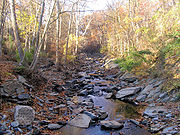
Today Little Falls Branch flows through a highly urbanizedUrbanized
Urbanized is a 2011 documentary film by Gary Hustwit released on 26 October 2011 and considered the third of a three-part series on design known as the Design Trilogy, the first being Helvetica about the typeface and the second being Objectified about industrial design.The documentary discusses...
area, and parts of the stream have been altered through construction of underground pipes, culvert
Culvert
A culvert is a device used to channel water. It may be used to allow water to pass underneath a road, railway, or embankment. Culverts can be made of many different materials; steel, polyvinyl chloride and concrete are the most common...
s and open concrete
Concrete
Concrete is a composite construction material, composed of cement and other cementitious materials such as fly ash and slag cement, aggregate , water and chemical admixtures.The word concrete comes from the Latin word...
channels. Portions of the stream flow through Little Falls Stream Valley Park in Bethesda and next to the Capital Crescent Trail
Capital Crescent Trail
The Capital Crescent Trail is an long, shared-use rail trail that runs from Georgetown in Washington, D.C., to Silver Spring, Maryland. The portion from Bethesda to Silver Spring is also called the Georgetown Branch Trail but is recognized as the Future Capital Crescent Trail.The Capital Crescent...
. The stream runs near the Dalecarlia drinking water treatment
Water purification
Water purification is the process of removing undesirable chemicals, materials, and biological contaminants from contaminated water. The goal is to produce water fit for a specific purpose...
plant in Washington and occasionally has received overflow discharges from the plant.
According to a study conducted by the county government, the water quality
Water quality
Water quality is the physical, chemical and biological characteristics of water. It is a measure of the condition of water relative to the requirements of one or more biotic species and or to any human need or purpose. It is most frequently used by reference to a set of standards against which...
of the stream and its tributaries is poor, due to water pollution
Water pollution
Water pollution is the contamination of water bodies . Water pollution occurs when pollutants are discharged directly or indirectly into water bodies without adequate treatment to remove harmful compounds....
from urban runoff
Urban runoff
Urban runoff is surface runoff of rainwater created by urbanization. This runoff is a major source of water pollution in many parts of the United States and other urban communities worldwide.-Overview:...
, as well as the channelization described above. The county and the Town of Somerset have installed several stream restoration
Stream restoration
Stream restoration or river restoration, sometimes called river reclamation in the UK, describes a set of activities that help improve the environmental health of a river or stream. Improved health may be indicated by expanded habitat for diverse species and reduced stream bank erosion...
projects throughout the watershed
Drainage basin
A drainage basin is an extent or an area of land where surface water from rain and melting snow or ice converges to a single point, usually the exit of the basin, where the waters join another waterbody, such as a river, lake, reservoir, estuary, wetland, sea, or ocean...
.
Tributaries of Little Falls Branch
- Dalecarlia Tributary
- Little Falls Mall Tributary
- Spring Valley Tributary
- Willet Branch