
Anacostia River
Overview
Mid-Atlantic States
The Mid-Atlantic states, also called middle Atlantic states or simply the mid Atlantic, form a region of the United States generally located between New England and the South...
of the United States
United States
The United States of America is a federal constitutional republic comprising fifty states and a federal district...
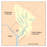
. It flows from Prince George's County
Prince George's County, Maryland
Prince George's County is a county located in the U.S. state of Maryland, immediately north, east, and south of Washington, DC. As of 2010, it has a population of 863,420 and is the wealthiest African-American majority county in the nation....
in Maryland
Maryland
Maryland is a U.S. state located in the Mid Atlantic region of the United States, bordering Virginia, West Virginia, and the District of Columbia to its south and west; Pennsylvania to its north; and Delaware to its east...
into Washington, D.C.
Washington, D.C.
Washington, D.C., formally the District of Columbia and commonly referred to as Washington, "the District", or simply D.C., is the capital of the United States. On July 16, 1790, the United States Congress approved the creation of a permanent national capital as permitted by the U.S. Constitution....
, where it joins with the Washington Channel
Washington Channel
The Washington Channel is a channel that parallels the Potomac River in Washington, D.C. It is located between the Southwest Waterfront on the east side and East Potomac Park on the west side. The channel is two miles long, receives outflow from the Tidal Basin at its north end, and empties into...
to empty into the Potomac River
Potomac River
The Potomac River flows into the Chesapeake Bay, located along the mid-Atlantic coast of the United States. The river is approximately long, with a drainage area of about 14,700 square miles...
at Buzzard Point
Buzzard Point
Buzzard Point is an urbanized area located on the peninsula formed by the confluence of the Potomac and Anacostia Rivers in the southwest quadrant of Washington, DC, USA.-History:...
. It is approximately 8.7 miles (14 km) long. The name "Anacostia" derives from the area's early history as Nacotchtank
Nacotchtank
The Nacotchtank were a native Algonquian people who lived in the area of what is now Washington, D.C. during the 17th century. Their principal village was situated within the modern borders of the District of Columbia, on the eastern bank of a small river that still bears an anglicised variant of...
, a settlement of Necostan or Anacostan Native American
Native Americans in the United States
Native Americans in the United States are the indigenous peoples in North America within the boundaries of the present-day continental United States, parts of Alaska, and the island state of Hawaii. They are composed of numerous, distinct tribes, states, and ethnic groups, many of which survive as...
s on the banks of the Anacostia River.
Heavy pollution
Water pollution
Water pollution is the contamination of water bodies . Water pollution occurs when pollutants are discharged directly or indirectly into water bodies without adequate treatment to remove harmful compounds....
in the Anacostia and weak investment and development
Land development
Land development refers to altering the landscape in any number of ways such as:* changing landforms from a natural or semi-natural state for a purpose such as agriculture or housing...
along its banks have led to it becoming what many have called "D.C.'s forgotten river." In recent years, however, private organizations, local businesses, and the D.C., Maryland
Government of Maryland
The government of Maryland is conducted according to the Maryland Constitution. The United States is a federation; consequently, the government of Maryland, like the other 49 state governments, has exclusive authority over matters that lie entirely within the state's borders, except as limited by...
and federal
Federal government of the United States
The federal government of the United States is the national government of the constitutional republic of fifty states that is the United States of America. The federal government comprises three distinct branches of government: a legislative, an executive and a judiciary. These branches and...
governments have made joint efforts to reduce its pollution levels in order to protect the ecologically valuable Anacostia watershed
Drainage basin
A drainage basin is an extent or an area of land where surface water from rain and melting snow or ice converges to a single point, usually the exit of the basin, where the waters join another waterbody, such as a river, lake, reservoir, estuary, wetland, sea, or ocean...
.
The mainstem of the Anacostia is formed by the confluence
Confluence
Confluence, in geography, describes the meeting of two or more bodies of water.Confluence may also refer to:* Confluence , a property of term rewriting systems...
of the Northwest Branch
Northwest Branch Anacostia River
Northwest Branch Anacostia River is a free-flowing stream in Montgomery County and Prince George's County, Maryland. It is a tributary of the Anacostia River, which flows to the Potomac River and the Chesapeake Bay.-Course:...
and the Northeast Branch
Northeast Branch Anacostia River
Northeast Branch Anacostia River is a free-flowing stream in Prince George's County, Maryland. It is a tributary of the Anacostia River, which flows to the Potomac River and the Chesapeake Bay.-Course:...
just north of Bladensburg, Maryland
Bladensburg, Maryland
Bladensburg is a town in Prince George's County, Maryland, United States. The population was 7,661 at the 2000 census.Bladensburg is from central Washington, DC...
.
Unanswered Questions