

Little Cacapon River
Encyclopedia
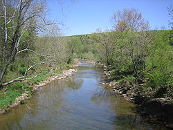
The Little Cacapon River is a 25.1 miles (40.4 km) free-flowing tributary of the Potomac River
in the center of Hampshire County
, West Virginia
. Via the Potomac River, its waters are part of the Chesapeake Bay
watershed, leading to the Atlantic Ocean
. The Little Cacapon enters the Potomac at an elevation of 499 feet (152.1 m) near the community of Little Cacapon
. For the majority of its course the Little Cacapon is a shallow non-navigable stream
. It has been historically referred to as both Little Cacapehon and Little Capecaphon. The name is pronounced kəˈkeɪpən or (locally) ˈkeɪpən .
 The Little Cacapon is formed at the confluence of two small streams, the North Fork Little Cacapon and the South Fork Little Cacapon, shortly after they both pass north under the Northwestern Turnpike
(U.S. Highway 50) at Frenchburg
. From Frenchburg, the Little Cacapon flows north between Town Hill, 1329 feet (405.1 m) high, to its west and Little Cacapon Mountain
, 1575 feet (480.1 m) high, to its east. Flowing from a hollow in Town Hill, Shawan Run feeds into the Little Cacapon at Barnes Mill
. Two miles (3 km) north, Three Churches Run also feeds into the river from Town Hill. At Higginsville
on Slanesville Pike (County Route 3) near the old Vinita School, the river is fed by Crooked Run at Queens Ridge (1322 feet (402.9 m) high). From Higginsville, the Little Cacapon continues northeast along Town Hill with 1161 feet (353.9 m) Noland Ridge bounding it to the east. Also in the vicinity of Higginsville, Little Cacapon-Levels Road (County Route 3/3) intersects with Slanesville Pike, and as its name suggests, the road follows the Little Cacapon north until it diverges northwest to Levels
via Hoffman Hollow. It is within this stretch of the stream that the Little Cacapon meanders by the community of Creekvale
. At the entrance of Neals Run, the Little Cacapon is met to its east by 2237 feet (681.8 m) Spring Gap Mountain
and then flows beneath the Baltimore and Ohio Railroad
and empties into the Potomac River
.
(3028 feet (922.9 m) high) joins the North Fork to its west, and along with Stony Mountain to its east, the river diverges from Grassy Lick Road and continues its northeastern route to Shanks
where it meets US Route 50. From Shanks, the North Fork merges with Camp Run and flows east under US Route 50 at Frenchburg, where it merges with the South Fork to create the Little Cacapon River.
and Ruckman
. From its source, the South Fork flows northeast toward Bell Hollow, where it meets US Route 50 and turns north through Frye's Flat towards Frenchburg. The South Fork continues north under US Route 50, where it immediately joins with the North Fork to form the Little Cacapon River alongside Little Cacapon River Road (County Route 50/9).
 Tributary
streams are listed in order from south to north.
Potomac River
The Potomac River flows into the Chesapeake Bay, located along the mid-Atlantic coast of the United States. The river is approximately long, with a drainage area of about 14,700 square miles...
in the center of Hampshire County
Hampshire County, West Virginia
Hampshire County is a county located in the U.S. state of West Virginia. As of 2010, the population was 23,964. Its county seat is Romney, West Virginia's oldest town . Hampshire County was created by the Virginia General Assembly on December 13, 1753, from parts of Frederick and Augusta counties ...
, West Virginia
West Virginia
West Virginia is a state in the Appalachian and Southeastern regions of the United States, bordered by Virginia to the southeast, Kentucky to the southwest, Ohio to the northwest, Pennsylvania to the northeast and Maryland to the east...
. Via the Potomac River, its waters are part of the Chesapeake Bay
Chesapeake Bay
The Chesapeake Bay is the largest estuary in the United States. It lies off the Atlantic Ocean, surrounded by Maryland and Virginia. The Chesapeake Bay's drainage basin covers in the District of Columbia and parts of six states: New York, Pennsylvania, Delaware, Maryland, Virginia, and West...
watershed, leading to the Atlantic Ocean
Atlantic Ocean
The Atlantic Ocean is the second-largest of the world's oceanic divisions. With a total area of about , it covers approximately 20% of the Earth's surface and about 26% of its water surface area...
. The Little Cacapon enters the Potomac at an elevation of 499 feet (152.1 m) near the community of Little Cacapon
Little Cacapon, West Virginia
Little Cacapon is an unincorporated community in Hampshire County in the U.S. state of West Virginia. Little Cacapon is located at the mouth of the Little Cacapon River on the Potomac, east of Okonoko. Okonoko-Little Cacapon Road and Spring Gap-Neals Run Road converge south of Little Cacapon...
. For the majority of its course the Little Cacapon is a shallow non-navigable stream
Stream
A stream is a body of water with a current, confined within a bed and stream banks. Depending on its locale or certain characteristics, a stream may be referred to as a branch, brook, beck, burn, creek, "crick", gill , kill, lick, rill, river, syke, bayou, rivulet, streamage, wash, run or...
. It has been historically referred to as both Little Cacapehon and Little Capecaphon. The name is pronounced kəˈkeɪpən or (locally) ˈkeɪpən .
Little Cacapon River
Northwestern Turnpike
The Northwestern Turnpike is a historic road in West Virginia , important for being historically one of the major roads crossing the Appalachians, financed by the Virginia Board of Public Works in the 1830s. In modern times, west of Winchester, Virginia, U.S...
(U.S. Highway 50) at Frenchburg
Frenchburg, West Virginia
Frenchburg is an unincorporated community in Hampshire County in the U.S. state of West Virginia. Frenchburg is located along the Northwestern Turnpike where the Little Cacapon River is formed by the confluence of the North and South forks of the Little Cacapon east of Shanks...
. From Frenchburg, the Little Cacapon flows north between Town Hill, 1329 feet (405.1 m) high, to its west and Little Cacapon Mountain
Little Cacapon Mountain
Little Cacapon Mountain is a mountain ridge of the Ridge-and-valley Appalachians in Hampshire County, West Virginia, United States. The mountain takes its name from the Little Cacapon River, a Potomac River tributary that lies on its western flanks. Little Cacapon Mountain reaches its highest point...
, 1575 feet (480.1 m) high, to its east. Flowing from a hollow in Town Hill, Shawan Run feeds into the Little Cacapon at Barnes Mill
Barnes Mill, West Virginia
Barnes Mill is an unincorporated community in Hampshire County in the U.S. state of West Virginia. It is located along the Little Cacapon River on Little Cacapon River Road north of Frenchburg. The original "Barnes Mill", from which the community takes its name, was built here on the Little...
. Two miles (3 km) north, Three Churches Run also feeds into the river from Town Hill. At Higginsville
Higginsville, West Virginia
Higginsville is an unincorporated community in Hampshire County, West Virginia, United States. Higginsville once served as a stagecoach stop on the old Cumberland Road between Winchester and Cumberland, now known as the Slanesville Pike ....
on Slanesville Pike (County Route 3) near the old Vinita School, the river is fed by Crooked Run at Queens Ridge (1322 feet (402.9 m) high). From Higginsville, the Little Cacapon continues northeast along Town Hill with 1161 feet (353.9 m) Noland Ridge bounding it to the east. Also in the vicinity of Higginsville, Little Cacapon-Levels Road (County Route 3/3) intersects with Slanesville Pike, and as its name suggests, the road follows the Little Cacapon north until it diverges northwest to Levels
Levels, West Virginia
Levels is an unincorporated community in Hampshire County in the U.S. state of West Virginia. According to the 2000 census, the Levels community has a population of 147. It is home to John J...
via Hoffman Hollow. It is within this stretch of the stream that the Little Cacapon meanders by the community of Creekvale
Creekvale, West Virginia
Creekvale is an unincorporated community in Hampshire County in the U.S. state of West Virginia. Creekvale is located southeast of Levels along the Little Cacapon River on Little Cacapon-Levels Road . Creekvale had a post office in operation from 1918 to 1935....
. At the entrance of Neals Run, the Little Cacapon is met to its east by 2237 feet (681.8 m) Spring Gap Mountain
Spring Gap Mountain
Spring Gap Mountain runs southwest northeast through Morgan and Hampshire counties in West Virginia's Eastern Panhandle, rising to its greatest elevation of north of "Spring Gap", from which the mountain takes its name...
and then flows beneath the Baltimore and Ohio Railroad
Baltimore and Ohio Railroad
The Baltimore and Ohio Railroad was one of the oldest railroads in the United States and the first common carrier railroad. It came into being mostly because the city of Baltimore wanted to compete with the newly constructed Erie Canal and another canal being proposed by Pennsylvania, which...
and empties into the Potomac River
Potomac River
The Potomac River flows into the Chesapeake Bay, located along the mid-Atlantic coast of the United States. The river is approximately long, with a drainage area of about 14,700 square miles...
.
Bridges
| Bridge | Route | Location |
|---|---|---|
| Little Cacapon Bridge | Little Cacapon River Road (CR 50/9) | Frenchburg Frenchburg, West Virginia Frenchburg is an unincorporated community in Hampshire County in the U.S. state of West Virginia. Frenchburg is located along the Northwestern Turnpike where the Little Cacapon River is formed by the confluence of the North and South forks of the Little Cacapon east of Shanks... |
| Barnes Mill Bridge | Little Cacapon River Road (CR 50/9) | Barnes Mill Barnes Mill, West Virginia Barnes Mill is an unincorporated community in Hampshire County in the U.S. state of West Virginia. It is located along the Little Cacapon River on Little Cacapon River Road north of Frenchburg. The original "Barnes Mill", from which the community takes its name, was built here on the Little... |
| CR 45/10 Bridge | Little Cacapon Mountain Road (CR 45/10) | Three Churches Three Churches, West Virginia Three Churches is an unincorporated community in Hampshire County in the U.S. state of West Virginia. The town is located north of Romney along Jersey Mountain Road at a crossroads with Three Churches Hollow Road... |
| Higginsville Bridge | Slanesville Pike (CR 3) | Higginsville Higginsville, West Virginia Higginsville is an unincorporated community in Hampshire County, West Virginia, United States. Higginsville once served as a stagecoach stop on the old Cumberland Road between Winchester and Cumberland, now known as the Slanesville Pike .... |
| CR 3/3 Bridge | Little Cacapon-Levels Road (CR 3/3) | Creekvale Creekvale, West Virginia Creekvale is an unincorporated community in Hampshire County in the U.S. state of West Virginia. Creekvale is located southeast of Levels along the Little Cacapon River on Little Cacapon-Levels Road . Creekvale had a post office in operation from 1918 to 1935.... |
| One-Lane Arch Bridge | Okonoko-Little Cacapon Road (CR 2/7) | Little Cacapon Little Cacapon, West Virginia Little Cacapon is an unincorporated community in Hampshire County in the U.S. state of West Virginia. Little Cacapon is located at the mouth of the Little Cacapon River on the Potomac, east of Okonoko. Okonoko-Little Cacapon Road and Spring Gap-Neals Run Road converge south of Little Cacapon... |
| Little Cacapon Railroad Bridge | Baltimore & Ohio Railroad | Little Cacapon Little Cacapon, West Virginia Little Cacapon is an unincorporated community in Hampshire County in the U.S. state of West Virginia. Little Cacapon is located at the mouth of the Little Cacapon River on the Potomac, east of Okonoko. Okonoko-Little Cacapon Road and Spring Gap-Neals Run Road converge south of Little Cacapon... |
North Fork Little Cacapon River
The North Fork is a 9.3 miles (15 km) tributary of the Little Cacapon. The North Fork's source lies in a hollow between 2618 feet (798 m) Piney Mountain and the southwestern end of 2274 feet (693.1 m) Stony Mountain. From its source, the North Fork flows northeast along Grassy Lick Road (County Route 10). South Branch MountainSouth Branch Mountain
South Branch Mountain is a mountain ridge that runs southwest to northeast through Hampshire and Hardy counties in the Eastern Panhandle of the U.S. state of West Virginia, rising to its greatest elevation of 3,028 feet above sea-level in the Nathaniel Mountain Wildlife Management Area...
(3028 feet (922.9 m) high) joins the North Fork to its west, and along with Stony Mountain to its east, the river diverges from Grassy Lick Road and continues its northeastern route to Shanks
Shanks, West Virginia
Shanks is an unincorporated community in Hampshire County in the U.S. state of West Virginia. According to the 2000 census, the Shanks community has a population of 806....
where it meets US Route 50. From Shanks, the North Fork merges with Camp Run and flows east under US Route 50 at Frenchburg, where it merges with the South Fork to create the Little Cacapon River.
South Fork Little Cacapon River
The South Fork is an 8.4 miles (13.5 km) tributary of the Little Cacapon. The South Fork is formed at its headwater in a hollow towards the southeastern end of Stony Mountain along South Fork of Little Cacapon Road (County Route 12) between the communities of KirbyKirby, West Virginia
Kirby is an unincorporated community in Hampshire County in the U.S. state of West Virginia situated along Grassy Lick Run, a tributary of North River. Kirby is located south of Romney at the crossroads of Grassy Lick Road and Rock Oak Road ....
and Ruckman
Ruckman, West Virginia
Ruckman is an unincorporated farming community in Hampshire County in the U.S. state of West Virginia. Ruckman is located at the intersections of Ash Ruckman Road with J.C. Ruckman and Edgar Loy Roads south of Augusta and northeast of Kirby. It is named for the Ruckman family that is still...
. From its source, the South Fork flows northeast toward Bell Hollow, where it meets US Route 50 and turns north through Frye's Flat towards Frenchburg. The South Fork continues north under US Route 50, where it immediately joins with the North Fork to form the Little Cacapon River alongside Little Cacapon River Road (County Route 50/9).
Tributaries
Tributary
A tributary or affluent is a stream or river that flows into a main stem river or a lake. A tributary does not flow directly into a sea or ocean...
streams are listed in order from south to north.
- South Fork Little Cacapon River
- Bell Hollow Run
- North Fork Little Cacapon River
- Camp Run
- Shawan Run
- Trinton Hollow Run
- Three Churches Run
- Graybill Hollow Run
- Crooked Run
- Hopkins Lick Run
- Dug Hill Run
- Hoffman Hollow Run
- Chimney Hollow Run
- Neals Run
- Lapley Hollow Run
List of cities and towns along the Little Cacapon River
- Barnes MillBarnes Mill, West VirginiaBarnes Mill is an unincorporated community in Hampshire County in the U.S. state of West Virginia. It is located along the Little Cacapon River on Little Cacapon River Road north of Frenchburg. The original "Barnes Mill", from which the community takes its name, was built here on the Little...
- CreekvaleCreekvale, West VirginiaCreekvale is an unincorporated community in Hampshire County in the U.S. state of West Virginia. Creekvale is located southeast of Levels along the Little Cacapon River on Little Cacapon-Levels Road . Creekvale had a post office in operation from 1918 to 1935....
- FrenchburgFrenchburg, West VirginiaFrenchburg is an unincorporated community in Hampshire County in the U.S. state of West Virginia. Frenchburg is located along the Northwestern Turnpike where the Little Cacapon River is formed by the confluence of the North and South forks of the Little Cacapon east of Shanks...
- HigginsvilleHigginsville, West VirginiaHigginsville is an unincorporated community in Hampshire County, West Virginia, United States. Higginsville once served as a stagecoach stop on the old Cumberland Road between Winchester and Cumberland, now known as the Slanesville Pike ....
- Little CacaponLittle Cacapon, West VirginiaLittle Cacapon is an unincorporated community in Hampshire County in the U.S. state of West Virginia. Little Cacapon is located at the mouth of the Little Cacapon River on the Potomac, east of Okonoko. Okonoko-Little Cacapon Road and Spring Gap-Neals Run Road converge south of Little Cacapon...
- ShanksShanks, West VirginiaShanks is an unincorporated community in Hampshire County in the U.S. state of West Virginia. According to the 2000 census, the Shanks community has a population of 806....