

The Trough
Encyclopedia
Allegheny Mountains
The Allegheny Mountain Range , also spelled Alleghany, Allegany and, informally, the Alleghenies, is part of the vast Appalachian Mountain Range of the eastern United States and Canada...
of Hampshire
Hampshire County, West Virginia
Hampshire County is a county located in the U.S. state of West Virginia. As of 2010, the population was 23,964. Its county seat is Romney, West Virginia's oldest town . Hampshire County was created by the Virginia General Assembly on December 13, 1753, from parts of Frederick and Augusta counties ...
and Hardy Counties
Hardy County, West Virginia
As of the census of 2000, there were 12,669 people, 5,204 households, and 3,564 families residing in the county. The population density was 22 people per square mile . There were 7,115 housing units at an average density of 12 per square mile...
, West Virginia
West Virginia
West Virginia is a state in the Appalachian and Southeastern regions of the United States, bordered by Virginia to the southeast, Kentucky to the southwest, Ohio to the northwest, Pennsylvania to the northeast and Maryland to the east...
, USA. The area was the site of a 1756 skirmish of the French and Indian War
French and Indian War
The French and Indian War is the common American name for the war between Great Britain and France in North America from 1754 to 1763. In 1756, the war erupted into the world-wide conflict known as the Seven Years' War and thus came to be regarded as the North American theater of that war...
, known as the "Battle of the Trough
Battle of the Trough
The Battle of the Trough was a skirmish of the early French and Indian War fought between Native Americans and British settlers in the valley of the South Branch Potomac River in what is now northern Hardy County, West Virginia, USA.-Background:After the defeat of General Edward Braddock at the...
".
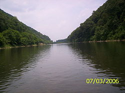
The steep slopes of the Trough are forested primarily with oaks
Oaks
-Horse races:"Oaks" is generally used to describe a Thoroughbred horse race restricted to 3-year-old fillies. Among the best-known races using the term are:*Epsom Oaks, The Oaks Stakes, at Epsom Downs Racecourse, Surrey, England; the original "Oaks" race...
, hickories
Hickory
Trees in the genus Carya are commonly known as hickory, derived from the Powhatan language of Virginia. The genus includes 17–19 species of deciduous trees with pinnately compound leaves and big nuts...
, and Virginia pine
Virginia Pine
Pinus virginiana is a medium-sized tree, often found on poorer soils from Long Island in southern New York south through the Appalachian Mountains to western Tennessee and Alabama. The usual size range for this pine is 9–18 m, but can grow taller under optimum conditions. The trunk can be...
with several rock outcrops
Outcrop
An outcrop is a visible exposure of bedrock or ancient superficial deposits on the surface of the Earth. -Features:Outcrops do not cover the majority of the Earth's land surface because in most places the bedrock or superficial deposits are covered by a mantle of soil and vegetation and cannot be...
visible on both sides. The two wooded ridges that define The Trough make it inaccessible from either side. Entry into The Trough is only by the South Branch Valley Railroad
South Branch Valley Railroad
The South Branch Valley Railroad consists of a 52.4 mile length of railroad in the U.S. state of West Virginia extending north along the South Branch Potomac River from Petersburg to the CSXT mainline at Green Spring adjacent to the Potomac River...
(along the foot of Mill Creek Mountain) or by canoe
Canoe
A canoe or Canadian canoe is a small narrow boat, typically human-powered, though it may also be powered by sails or small electric or gas motors. Canoes are usually pointed at both bow and stern and are normally open on top, but can be decked over A canoe (North American English) or Canadian...
or boat.
Geography
The Trough is a narrow valley bounded by Mill Creek MountainMill Creek Mountain
Mill Creek Mountain is a continuous mountain ridge that runs northeast through Hampshire and Hardy counties in the Eastern Panhandle region of the U.S. state of West Virginia. Rising to its greatest elevation of 2,648 feet above sea-level at High Knob, Mill Creek is a folded mountain ridge,...
to its west and Sawmill Ridge (1,716 feet) to its east with the South Branch Potomac River flowing in between them. The Trough's opening is located at the southern slopes of Mill Creek Mountain and Sawmill Ridge at McNeill
McNeill, West Virginia
McNeill is an unincorporated community in Hardy County, West Virginia, USA. It lies near the South Branch Potomac River on Trough Road ....
in Hardy County. Mill Creek Mountain on its western edge is made up of steep several ridges and knobs while Sawmill Ridge to its east is one long continuous sharp ridge. River Ridge (1,906 feet) is the first of Mill Creek Mountain's ridges to rise over the South Branch. For canoers, The Trough officially begins at the South Branch Valley Railroad's wooden trestle at Sycamore just after Stony Run empties into the river.
The Trough continues its northwestern track with several bends in the South Branch Potomac and large boulders dislocated from the ridges above dotting its shores. The Trough then passes into Hampshire County at High Knob
High Knob (West Virginia)
High Knob is a mountain summit on the border between Hampshire and Hardy counties in West Virginia's Eastern Panhandle. High Knob is known for its overlook of The Trough and of points in three counties. A historical marker was placed on U.S. Route 220/West Virginia Route 28 noting its scenic and...
(2,648 feet) on Mill Creek Mountain followed by a series of knobs separated by spring gaps. It is at the third spring gap where Wickham
Wickham, Hampshire County, West Virginia
Wickham is an extinct unincorporated community in Hampshire County in the U.S. state of West Virginia. Wickham originally developed as a stop on the South Branch Valley Railroad in the Trough. Wickham is located within a gap in Mill Creek Mountain on the South Branch Potomac River. One white...
was once located at on the railroad. Following Wickham, Mill Creek Mountain's Long Knob (1,725 feet) spans the western side of The Trough while Sawmill Ridge remains to its east. Sawmill Ridge ends at The Trough's Mouth where Sawmill Run runs off it and joins the river. Sector
Sector, West Virginia
Sector is an unincorporated community in Hampshire County in the U.S. state of West Virginia. It is located along the west bank of the South Branch Potomac River on Fleming-Sector Road across from Glebe....
is located at the mouth's western edge with Glebe
Glebe, West Virginia
Glebe is an unincorporated community in Hampshire County, West Virginia, USA. Glebe is situated at the mouth of the Trough on the South Branch Potomac River 9.5 miles southwest of Romney on South Branch River Road . The community received its name from the old stone glebehouse that was constructed...
located to its east. The cement supports of the old bridge that once carried Fleming-Sector Road (County Route 8/3) connecting these two communities are still visible on either side of the river. For canoers, Th
Recreation
The Trough General Store in GlebeGlebe, West Virginia
Glebe is an unincorporated community in Hampshire County, West Virginia, USA. Glebe is situated at the mouth of the Trough on the South Branch Potomac River 9.5 miles southwest of Romney on South Branch River Road . The community received its name from the old stone glebehouse that was constructed...
at The Trough's mouth offers canoe rentals and shuttles canoers and kayakers to The Trough's opening near McNeill in the South Branch Wildlife Management Area
South Branch Wildlife Management Area
The South Branch Wildlife Management Area is of mixed oak-hickory woodlands and pastures in Hampshire and Hardy Counties, West Virginia, USA. The South Branch WMA consists of four separate tracts along the South Branch Potomac River around and south of the river gorge known as The Trough...
.
The area is well-known as a habitat for endangered
Endangered species
An endangered species is a population of organisms which is at risk of becoming extinct because it is either few in numbers, or threatened by changing environmental or predation parameters...
bald eagles, hence its Potomac Eagle Scenic Railroad
Potomac Eagle Scenic Railroad
The Potomac Eagle Scenic Railroad is a heritage railroad based in Romney, West Virginia.The railroad operates excursion trains over a former Baltimore and Ohio Railroad line that runs from Green Spring to Petersburg...
sightseeing train on the SBVR. Visitors can board the train at Wappocomo Station on West Virginia Route 28 in Romney
Romney, West Virginia
Romney is a city in and the county seat of Hampshire County, West Virginia, United States. The population was 1,940 at the 2000 census, while the area covered by the city's ZIP code had a population of 5,873. It is a city with a very historic background dating back to the 18th century...
.
See also
- South Branch Wildlife Management AreaSouth Branch Wildlife Management AreaThe South Branch Wildlife Management Area is of mixed oak-hickory woodlands and pastures in Hampshire and Hardy Counties, West Virginia, USA. The South Branch WMA consists of four separate tracts along the South Branch Potomac River around and south of the river gorge known as The Trough...