
Four Mile Run
Encyclopedia
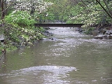
Four Mile Run is a 9.4 miles (15.1 km) stream
in northern
Virginia
that starts near Interstate 66
, at Gordon Avenue in Fairfax County
and proceeds southeast through Falls Church
to Arlington County
in the U.S. state
of Virginia
. Most of the stretch is park
land and is paralleled by two paved non-motorized transport and recreational trails, the Washington & Old Dominion Railroad Trail and the Four Mile Run Trail
.
In Arlington, the stream passes from the Piedmont
through the fall line
to the Atlantic Coastal Plain
in a deep forested valley. The stream's eastern section forms the boundary of Arlington County and the City of Alexandria
. The stream eventually empties out into the Potomac River
immediately south of National Airport.
The name Four Mile Run does not derive from its length, but was, in fact, a misreading of an old map. An old flour mill near the Potomac gave the stream the name of "Flour Mill Run", but the map had faded letters. Four Mile Run runs into the tidal Four Mile Creek within 1 mile (2 km) of the mouth of the stream.
and the 19th century, several watermill
s existed in and near the fall line of the stream. Although none of these mills remain intact, the foundation of one is still in place (Arlington Mill constructed in 1836; later rebuilt as Barcroft Mill in 1880 after being destroyed by Union Army
troops during the Civil War
). The mill provided locals with flour ground from corn and wheat that was grown locally and shipped up the stream on flatboats. Located west of the stream between Columbia Pike and 10th Street South in Arlington, the foundation presently supports an automobile repair shop.
 General George Washington
owned on the southwest side of the stream in the fall line a large parcel of wooded property which he surveyed in 1785, several years after the Revolutionary War
ended. As part of this survey, Washington made a cut in the trunk of an oak tree
to mark a corner of his property where a tributary (Long Branch (upper)) entered the main stream. A portion of this trunk remains preserved in a neighborhood library (Glencarlyn Library), while a columnar monument marks the tree's original location.
From about 1860 to 1968, the Washington and Old Dominion Railroad
and its predecessors traveled along most of the stream's length in Arlington. The Northern Virginia Regional Park Authority's Washington and Old Dominion Railroad Trail
now travels along the stream on the former railroad's route. In the late 19th century, a small resort at Carlin Springs became a favorite respite for Washingtonians who would ride the train out for bathing and dancing. Carlin Springs was located within the present day Glencarlyn Park, along Four Mile Run, and surrounding Glencarlyn Neighborhood.
From 1906 to 1915, the Luna Park amusement complex operated on the banks of Four Mile Run near its confluence
with the Potomac. According to publicity, it was an "architecture fashion plate," featuring ballrooms, restaurants, roller coasters, shoot-the-chutes
, circus performances, and exhilarating rides. Early residents frequently cooled off in the deeper pools of Four Mile Run, even though the water must have been polluted by sewage. Not until the 1930s did the county build a centralized sewage system, with a treatment plant on the site of the old Luna Park.
In June 1972, rains from Hurricane Agnes
caused the stream to overflow its banks, producing extensive flooding which was especially severe in a populated area on the coastal plain. As a result of this event, the Army Corps of Engineers channelized the stream in this and other areas, covering the stream's natural banks with riprap
.
Connecting trails are:
It is possible to bicycle or hike a triangle route that passes along all three of these trails.
Stream
A stream is a body of water with a current, confined within a bed and stream banks. Depending on its locale or certain characteristics, a stream may be referred to as a branch, brook, beck, burn, creek, "crick", gill , kill, lick, rill, river, syke, bayou, rivulet, streamage, wash, run or...
in northern
Northern Virginia
Northern Virginia consists of several counties and independent cities in the Commonwealth of Virginia, in a widespread region generally radiating southerly and westward from Washington, D.C...
Virginia
Virginia
The Commonwealth of Virginia , is a U.S. state on the Atlantic Coast of the Southern United States. Virginia is nicknamed the "Old Dominion" and sometimes the "Mother of Presidents" after the eight U.S. presidents born there...
that starts near Interstate 66
Interstate 66
Interstate 66 is an Interstate Highway in the eastern United States. As indicated by its even route number, it runs in an east–west direction. Its western terminus is at Middletown, Virginia, at an intersection with Interstate 81; its eastern terminus is in Washington, D.C., at an...
, at Gordon Avenue in Fairfax County
Fairfax County, Virginia
Fairfax County is a county in Virginia, in the United States. Per the 2010 Census, the population of the county is 1,081,726, making it the most populous jurisdiction in the Commonwealth of Virginia, with 13.5% of Virginia's population...
and proceeds southeast through Falls Church
Falls Church, Virginia
The City of Falls Church is an independent city in Virginia, United States, in the Washington Metropolitan Area. The city population was 12,332 in 2010, up from 10,377 in 2000. Taking its name from The Falls Church, an 18th-century Anglican parish, Falls Church gained township status within...
to Arlington County
Arlington County, Virginia
Arlington County is a county in the Commonwealth of Virginia. The land that became Arlington was originally donated by Virginia to the United States government to form part of the new federal capital district. On February 27, 1801, the United States Congress organized the area as a subdivision of...
in the U.S. state
U.S. state
A U.S. state is any one of the 50 federated states of the United States of America that share sovereignty with the federal government. Because of this shared sovereignty, an American is a citizen both of the federal entity and of his or her state of domicile. Four states use the official title of...
of Virginia
Virginia
The Commonwealth of Virginia , is a U.S. state on the Atlantic Coast of the Southern United States. Virginia is nicknamed the "Old Dominion" and sometimes the "Mother of Presidents" after the eight U.S. presidents born there...
. Most of the stretch is park
Park
A park is a protected area, in its natural or semi-natural state, or planted, and set aside for human recreation and enjoyment, or for the protection of wildlife or natural habitats. It may consist of rocks, soil, water, flora and fauna and grass areas. Many parks are legally protected by...
land and is paralleled by two paved non-motorized transport and recreational trails, the Washington & Old Dominion Railroad Trail and the Four Mile Run Trail
Four Mile Run Trail
The Four Mile Run Trail is a 7-mile, paved bike trail in Arlington County, Virginia that runs along Four Mile Run from Falls Church to the Mount Vernon Trail near Ronald Reagan Washington National Airport, where Four Mile Run empties into the Potomac River...
.
In Arlington, the stream passes from the Piedmont
Piedmont (United States)
The Piedmont is a plateau region located in the eastern United States between the Atlantic Coastal Plain and the main Appalachian Mountains, stretching from New Jersey in the north to central Alabama in the south. The Piedmont province is a physiographic province of the larger Appalachian division...
through the fall line
Fall line
A fall line is a geomorphologic unconformity between an upland region of relatively hard crystalline basement rock and a coastal plain of softer sedimentary rock. A fall line is typically prominent when crossed by a river, for there will often be rapids or waterfalls...
to the Atlantic Coastal Plain
Atlantic Coastal Plain
The Atlantic coastal plain has both low elevation and low relief, but it is also a relatively flat landform extending from the New York Bight southward to a Georgia/Florida section of the Eastern Continental Divide, which demarcates the plain from the ACF River Basin in the Gulf Coastal Plain to...
in a deep forested valley. The stream's eastern section forms the boundary of Arlington County and the City of Alexandria
Alexandria, Virginia
Alexandria is an independent city in the Commonwealth of Virginia. As of 2009, the city had a total population of 139,966. Located along the Western bank of the Potomac River, Alexandria is approximately six miles south of downtown Washington, D.C.Like the rest of northern Virginia, as well as...
. The stream eventually empties out into the Potomac River
Potomac River
The Potomac River flows into the Chesapeake Bay, located along the mid-Atlantic coast of the United States. The river is approximately long, with a drainage area of about 14,700 square miles...
immediately south of National Airport.
The name Four Mile Run does not derive from its length, but was, in fact, a misreading of an old map. An old flour mill near the Potomac gave the stream the name of "Flour Mill Run", but the map had faded letters. Four Mile Run runs into the tidal Four Mile Creek within 1 mile (2 km) of the mouth of the stream.
History
During the colonial periodColonial Period
Colonial Period may generally refer to any period in a country's history when it was subject to administration by a colonial power.*Korea under Japanese rule*Colonial history of the United States...
and the 19th century, several watermill
Watermill
A watermill is a structure that uses a water wheel or turbine to drive a mechanical process such as flour, lumber or textile production, or metal shaping .- History :...
s existed in and near the fall line of the stream. Although none of these mills remain intact, the foundation of one is still in place (Arlington Mill constructed in 1836; later rebuilt as Barcroft Mill in 1880 after being destroyed by Union Army
Union Army
The Union Army was the land force that fought for the Union during the American Civil War. It was also known as the Federal Army, the U.S. Army, the Northern Army and the National Army...
troops during the Civil War
American Civil War
The American Civil War was a civil war fought in the United States of America. In response to the election of Abraham Lincoln as President of the United States, 11 southern slave states declared their secession from the United States and formed the Confederate States of America ; the other 25...
). The mill provided locals with flour ground from corn and wheat that was grown locally and shipped up the stream on flatboats. Located west of the stream between Columbia Pike and 10th Street South in Arlington, the foundation presently supports an automobile repair shop.
George Washington
George Washington was the dominant military and political leader of the new United States of America from 1775 to 1799. He led the American victory over Great Britain in the American Revolutionary War as commander-in-chief of the Continental Army from 1775 to 1783, and presided over the writing of...
owned on the southwest side of the stream in the fall line a large parcel of wooded property which he surveyed in 1785, several years after the Revolutionary War
American Revolutionary War
The American Revolutionary War , the American War of Independence, or simply the Revolutionary War, began as a war between the Kingdom of Great Britain and thirteen British colonies in North America, and ended in a global war between several European great powers.The war was the result of the...
ended. As part of this survey, Washington made a cut in the trunk of an oak tree
Oak
An oak is a tree or shrub in the genus Quercus , of which about 600 species exist. "Oak" may also appear in the names of species in related genera, notably Lithocarpus...
to mark a corner of his property where a tributary (Long Branch (upper)) entered the main stream. A portion of this trunk remains preserved in a neighborhood library (Glencarlyn Library), while a columnar monument marks the tree's original location.
From about 1860 to 1968, the Washington and Old Dominion Railroad
Washington and Old Dominion Railroad
The Washington and Old Dominion Railroad was an intrastate short-line railroad located in Northern Virginia. Its oldest line extended from Alexandria on the Potomac River northwest to Bluemont at the foot of the Blue Ridge Mountains near Snickers Gap, not far from the boundary line between...
and its predecessors traveled along most of the stream's length in Arlington. The Northern Virginia Regional Park Authority's Washington and Old Dominion Railroad Trail
Washington & Old Dominion Railroad Regional Park
The Washington & Old Dominion Railroad Regional Park is a popular and unusually-shaped regional park in Northern Virginia. The park's primary feature is the Washington & Old Dominion Railroad Trail , an asphalt-surfaced paved rail trail that runs through densely populated urban and suburban...
now travels along the stream on the former railroad's route. In the late 19th century, a small resort at Carlin Springs became a favorite respite for Washingtonians who would ride the train out for bathing and dancing. Carlin Springs was located within the present day Glencarlyn Park, along Four Mile Run, and surrounding Glencarlyn Neighborhood.
From 1906 to 1915, the Luna Park amusement complex operated on the banks of Four Mile Run near its confluence
Confluence
Confluence, in geography, describes the meeting of two or more bodies of water.Confluence may also refer to:* Confluence , a property of term rewriting systems...
with the Potomac. According to publicity, it was an "architecture fashion plate," featuring ballrooms, restaurants, roller coasters, shoot-the-chutes
Shoot-the-Chutes
Shoot-the-Chutes is an amusement ride consisting of a flat-bottomed boat that slides down a ramp or inside a flume into a lagoon. Unlike a log flume, a Shoot-the-Chutes generally has larger boats and one single drop....
, circus performances, and exhilarating rides. Early residents frequently cooled off in the deeper pools of Four Mile Run, even though the water must have been polluted by sewage. Not until the 1930s did the county build a centralized sewage system, with a treatment plant on the site of the old Luna Park.
In June 1972, rains from Hurricane Agnes
Hurricane Agnes
Hurricane Agnes was the first tropical storm and first hurricane of the 1972 Atlantic hurricane season. A rare June hurricane, it made landfall on the Florida Panhandle before moving northeastward and ravaging the Mid-Atlantic region as a tropical storm...
caused the stream to overflow its banks, producing extensive flooding which was especially severe in a populated area on the coastal plain. As a result of this event, the Army Corps of Engineers channelized the stream in this and other areas, covering the stream's natural banks with riprap
Riprap
Riprap — also known as rip rap, rubble, shot rock or rock armour or "Rip-rap" — is rock or other material used to armor shorelines, streambeds, bridge abutments, pilings and other shoreline structures against scour, water or ice erosion.It is made from a variety of rock types, commonly granite or...
.
Tributaries
Tributaries are listed in order from the source of Four Mile Run to its mouth.| Tributary | Side of Main Stream |
Coordinates of Tributary near Confluence |
|---|---|---|
| Lubber Run | Northeast | 38.865847°N 77.11992°W |
| Long Branch (lower) | Southwest | 38.861845°N 77.118544°W |
| Doctors Run (Doctors Branch) | Northeast | 38.849969°N 77.103006°W |
| Lucky Run | Southwest | 38.845996°N 77.096751°W |
| Long Branch (upper) | North | 38.844861°N 77.071321°W |
Parks
The parks through or adjacent to which Four Mile Run flows, from the source of the stream to its mouth, are:- Washington & Old Dominion Railroad Regional ParkWashington & Old Dominion Railroad Regional ParkThe Washington & Old Dominion Railroad Regional Park is a popular and unusually-shaped regional park in Northern Virginia. The park's primary feature is the Washington & Old Dominion Railroad Trail , an asphalt-surfaced paved rail trail that runs through densely populated urban and suburban...
, Arlington - Crossman Park, Falls Church
- Benjamin Banneker Park, Arlington
- Madison Manor Park, Arlington
- Bon Air Park, Arlington
- Bluemont Junction Park, Arlington (narrow trail from Fields Park to Bluemont Park that runs perpendicular to Four Mile Run)
- Bluemont Park, Arlington
- Glencarlyn Park, Arlington
- Barcroft Park, Arlington
- Shirlington Park, Arlington
- Jennie Dean Park, Arlington
- Four Mile Run Park, Alexandria
- George Washington Memorial ParkwayGeorge Washington Memorial ParkwayThe George Washington Memorial Parkway, known to local motorists simply as the "G.W. Parkway", is a parkway maintained by the U.S. National Park Service. It is located mostly in Northern Virginia, although a short section northwest of the Arlington Memorial Bridge passes over Columbia Island,...
(national park), Arlington and Alexandria
Trails
The paved trails that travel near Four Mile Run are:- Washington & Old Dominion Railroad Trail, Arlington
- Four Mile Run TrailFour Mile Run TrailThe Four Mile Run Trail is a 7-mile, paved bike trail in Arlington County, Virginia that runs along Four Mile Run from Falls Church to the Mount Vernon Trail near Ronald Reagan Washington National Airport, where Four Mile Run empties into the Potomac River...
, Arlington - Wayne F. Anderson Bikeway, Arlington and Alexandria
Connecting trails are:
- Mount Vernon TrailMount Vernon TrailThe Mount Vernon Trail is a popular running and bike path in Northern Virginia that follows the west bank of the Potomac River from near Theodore Roosevelt Island to Mount Vernon. The northern, urban half is open and has views of Washington, D.C. across the river. The southern below Alexandria is...
- Bluemont Junction Trail, Arlington
- Custis TrailCustis TrailThe Custis Trail is a 4-mile, paved bike trail in Arlington County, Virginia that extends from Key Bridge at Rosslyn westward to the Washington & Old Dominion Railroad Trail...
(along I-66), Arlington
It is possible to bicycle or hike a triangle route that passes along all three of these trails.