
Fall line
Encyclopedia
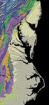
A fall line is a geomorphologic
unconformity
(e.g., monoclinal
faulting and/or flexing) between an upland region of relatively hard crystalline basement rock
and a coastal plain
of softer sedimentary rock
. A fall line is typically prominent when crossed by a river, for there will often be rapids or waterfall
s. Many times a fall line will recede upstream as the river cuts out the uphill dense material, often forming “c”-shaped waterfalls. Because of these features riverboats typically cannot travel any farther inland without portaging
, unless locks are built there. On the other hand, the rapid change in elevation of the water, and the resulting energy release, makes the fall line a good location for water mills, grist mills, and sawmill
s. Because of the need for a river port leading to the ocean, and a ready supply of water power, settlements often develop where rivers cross a fall line.
(on the Niagara Escarpment
) and Columbia, South Carolina
(on the Atlantic Seaboard fall line
). Other cities along fall lines of the United States include:
where the Piedmont
and Atlantic Coastal Plain
meet in the eastern United States
. Much of the Atlantic Seaboard fall line passes through areas where no evidence of faulting is present.
The fall line marks the geologic boundary of hard metamorphosed terrain—the product of the Taconic orogeny
—and the sandy, relatively flat outwash plain of the upper continental shelf, formed of unconsolidated Cretaceous
and Tertiary
sediment
s. Examples of the Fall Zone include the Potomac River's Great Falls and the rapids in Richmond, Virginia
, where the James River
falls across a series of rapids down to the tidal estuary of the James River. Columbia, South Carolina
is similar as well with the Congaree River
.
Before navigation improvements such as locks, the fall line was often the head of navigation on rivers due to rapids and waterfalls, such as the Great Falls of the Potomac River
. Numerous cities were founded at the intersection of rivers and the fall line. U.S. Route 1
links many of the fall line cities.
Geomorphology
Geomorphology is the scientific study of landforms and the processes that shape them...
unconformity
Unconformity
An unconformity is a buried erosion surface separating two rock masses or strata of different ages, indicating that sediment deposition was not continuous. In general, the older layer was exposed to erosion for an interval of time before deposition of the younger, but the term is used to describe...
(e.g., monoclinal
Monocline
A monocline is a step-like fold in rock strata consisting of a zone of steeper dip within an otherwise horizontal or gently-dipping sequence.-Formation:Monoclines may be formed in several different ways...
faulting and/or flexing) between an upland region of relatively hard crystalline basement rock
Basement (geology)
In geology, the terms basement and crystalline basement are used to define the rocks below a sedimentary platform or cover, or more generally any rock below sedimentary rocks or sedimentary basins that are metamorphic or igneous in origin...
and a coastal plain
Coastal plain
A coastal plain is an area of flat, low-lying land adjacent to a seacoast and separated from the interior by other features. One of the world's longest coastal plains is located in eastern South America. The southwestern coastal plain of North America is notable for its species diversity...
of softer sedimentary rock
Sedimentary rock
Sedimentary rock are types of rock that are formed by the deposition of material at the Earth's surface and within bodies of water. Sedimentation is the collective name for processes that cause mineral and/or organic particles to settle and accumulate or minerals to precipitate from a solution....
. A fall line is typically prominent when crossed by a river, for there will often be rapids or waterfall
Waterfall
A waterfall is a place where flowing water rapidly drops in elevation as it flows over a steep region or a cliff.-Formation:Waterfalls are commonly formed when a river is young. At these times the channel is often narrow and deep. When the river courses over resistant bedrock, erosion happens...
s. Many times a fall line will recede upstream as the river cuts out the uphill dense material, often forming “c”-shaped waterfalls. Because of these features riverboats typically cannot travel any farther inland without portaging
Portage
Portage or portaging refers to the practice of carrying watercraft or cargo over land to avoid river obstacles, or between two bodies of water. A place where this carrying occurs is also called a portage; a person doing the carrying is called a porter.The English word portage is derived from the...
, unless locks are built there. On the other hand, the rapid change in elevation of the water, and the resulting energy release, makes the fall line a good location for water mills, grist mills, and sawmill
Sawmill
A sawmill is a facility where logs are cut into boards.-Sawmill process:A sawmill's basic operation is much like those of hundreds of years ago; a log enters on one end and dimensional lumber exits on the other end....
s. Because of the need for a river port leading to the ocean, and a ready supply of water power, settlements often develop where rivers cross a fall line.
Fall lines of the United States
The slope of fall zones on rivers played a role in settlement patterns. For example, fall lines proved useful for hydroelectric dams such as at Rochester, New YorkRochester, New York
Rochester is a city in Monroe County, New York, south of Lake Ontario in the United States. Known as The World's Image Centre, it was also once known as The Flour City, and more recently as The Flower City...
(on the Niagara Escarpment
Niagara Escarpment
The Niagara Escarpment is a long escarpment, or cuesta, in the United States and Canada that runs westward from New York State, through Ontario, Michigan, Wisconsin and Illinois...
) and Columbia, South Carolina
Columbia, South Carolina
Columbia is the state capital and largest city in the U.S. state of South Carolina. The population was 129,272 according to the 2010 census. Columbia is the county seat of Richland County, but a portion of the city extends into neighboring Lexington County. The city is the center of a metropolitan...
(on the Atlantic Seaboard fall line
Atlantic Seaboard fall line
The Atlantic Seaboard Fall Line, or Fall Zone, is a escarpment where the Piedmont and Atlantic coastal plain meet in the eastern United States...
). Other cities along fall lines of the United States include:
- New EnglandNew EnglandNew England is a region in the northeastern corner of the United States consisting of the six states of Maine, New Hampshire, Vermont, Massachusetts, Rhode Island, and Connecticut...
fall line: - Lowell, MassachusettsLowell, MassachusettsLowell is a city in Middlesex County, Massachusetts, USA. According to the 2010 census, the city's population was 106,519. It is the fourth largest city in the state. Lowell and Cambridge are the county seats of Middlesex County...
(Merrimack RiverMerrimack RiverThe Merrimack River is a river in the northeastern United States. It rises at the confluence of the Pemigewasset and Winnipesaukee rivers in Franklin, New Hampshire, flows southward into Massachusetts, and then flows northeast until it empties into the Atlantic Ocean at Newburyport...
). - Hartford, ConnecticutHartford, ConnecticutHartford is the capital of the U.S. state of Connecticut. The seat of Hartford County until Connecticut disbanded county government in 1960, it is the second most populous city on New England's largest river, the Connecticut River. As of the 2010 Census, Hartford's population was 124,775, making...
(Connecticut RiverConnecticut RiverThe Connecticut River is the largest and longest river in New England, and also an American Heritage River. It flows roughly south, starting from the Fourth Connecticut Lake in New Hampshire. After flowing through the remaining Connecticut Lakes and Lake Francis, it defines the border between the...
). - Fall River, MassachusettsFall River, MassachusettsFall River is a city in Bristol County, Massachusetts, in the United States. It is located about south of Boston, southeast of Providence, Rhode Island, and west of New Bedford and south of Taunton. The city's population was 88,857 during the 2010 census, making it the tenth largest city in...
(Quequechan RiverQuequechan RiverThe Quequechan River , is a river in Fall River, Massachusetts that flows in a northwesterly direction from the South Watuppa Pond to the Taunton River. The word Quequechan means "falling water" in Wampanoag, hence the city's name....
). - Bangor, MaineBangor, MaineBangor is a city in and the county seat of Penobscot County, Maine, United States, and the major commercial and cultural center for eastern and northern Maine...
(Penobscot RiverPenobscot RiverThe Penobscot River is a river in the U.S. state of Maine. Including the river's West Branch and South Branch increases the Penobscot's length to , making it the second longest river system in Maine and the longest entirely in the state. Its drainage basin contains .It arises from four branches...
). - Augusta, MaineAugusta, MaineAugusta is the capital of the US state of Maine, county seat of Kennebec County, and center of population for Maine. The city's population was 19,136 at the 2010 census, making it the third-smallest state capital after Montpelier, Vermont and Pierre, South Dakota...
(Kennebec RiverKennebec RiverThe Kennebec River is a river that is entirely within the U.S. state of Maine. It rises in Moosehead Lake in west-central Maine. The East and West Outlets join at Indian Pond and the river then flows southward...
).
- OnondagaOnondaga (geological formation)The Onondaga Formation is a group of hard limestones and dolostones of Devonian age that form an important geographic feature in some areas in which it outcrops, in others; especially its Southern Ontario portion, the formation can be less prominent as a local surface feature.In upstate New York...
fall line: - Albany, New YorkAlbany, New YorkAlbany is the capital city of the U.S. state of New York, the seat of Albany County, and the central city of New York's Capital District. Roughly north of New York City, Albany sits on the west bank of the Hudson River, about south of its confluence with the Mohawk River...
(Hudson RiverHudson RiverThe Hudson is a river that flows from north to south through eastern New York. The highest official source is at Lake Tear of the Clouds, on the slopes of Mount Marcy in the Adirondack Mountains. The river itself officially begins in Henderson Lake in Newcomb, New York...
).
- Southern fall line:
- Washington, D.C.Washington, D.C.Washington, D.C., formally the District of Columbia and commonly referred to as Washington, "the District", or simply D.C., is the capital of the United States. On July 16, 1790, the United States Congress approved the creation of a permanent national capital as permitted by the U.S. Constitution....
on the Potomac RiverPotomac RiverThe Potomac River flows into the Chesapeake Bay, located along the mid-Atlantic coast of the United States. The river is approximately long, with a drainage area of about 14,700 square miles... - Alexandria, VirginiaAlexandria, VirginiaAlexandria is an independent city in the Commonwealth of Virginia. As of 2009, the city had a total population of 139,966. Located along the Western bank of the Potomac River, Alexandria is approximately six miles south of downtown Washington, D.C.Like the rest of northern Virginia, as well as...
on the Potomac RiverPotomac RiverThe Potomac River flows into the Chesapeake Bay, located along the mid-Atlantic coast of the United States. The river is approximately long, with a drainage area of about 14,700 square miles... - Fredericksburg, VirginiaFredericksburg, VirginiaFredericksburg is an independent city in the Commonwealth of Virginia located south of Washington, D.C., and north of Richmond. As of the 2010 census, the city had a population of 24,286...
on the Rappahannock RiverRappahannock RiverThe Rappahannock River is a river in eastern Virginia, in the United States, approximately in length. It traverses the entire northern part of the state, from the Blue Ridge Mountains in the west, across the Piedmont, to the Chesapeake Bay, south of the Potomac River.An important river in American... - Richmond, VirginiaRichmond, VirginiaRichmond is the capital of the Commonwealth of Virginia, in the United States. It is an independent city and not part of any county. Richmond is the center of the Richmond Metropolitan Statistical Area and the Greater Richmond area...
on the James RiverJames RiverThe James River may refer to:Rivers in the United States and their namesakes* James River * James River , North Dakota, South Dakota* James River * James River * James River... - Petersburg, VirginiaPetersburg, VirginiaPetersburg is an independent city in Virginia, United States located on the Appomattox River and south of the state capital city of Richmond. The city's population was 32,420 as of 2010, predominantly of African-American ethnicity...
on the Appomattox RiverAppomattox RiverThe Appomattox River is a tributary of the James River, approximately long, in central and eastern Virginia in the United States, named for the Appomattocs Indian tribe who lived along its lower banks in the 17th century... - Roanoke Rapids, North CarolinaRoanoke Rapids, North CarolinaRoanoke Rapids is a city in Halifax County, North Carolina, United States. The population was 16,957 at the 2000 census. It is the principal city of the Roanoke Rapids Micropolitan Statistical Area.-Geography:...
on the Roanoke RiverRoanoke RiverThe Roanoke River is a river in southern Virginia and northeastern North Carolina in the United States, 410 mi long. A major river of the southeastern United States, it drains a largely rural area of the coastal plain from the eastern edge of the Appalachian Mountains southeast across the Piedmont... - Fayetteville, North CarolinaFayetteville, North CarolinaFayetteville is a city located in Cumberland County, North Carolina, United States. It is the county seat of Cumberland County, and is best known as the home of Fort Bragg, a U.S. Army post located northwest of the city....
on the Cape Fear RiverCape Fear RiverThe Cape Fear River is a long blackwater river in east central North Carolina in the United States. It flows into the Atlantic Ocean near Cape Fear, from which it takes its name. The overall water quality of the river is continuously measured and monitored by and conducted by the , , and the... - Columbia, South CarolinaColumbia, South CarolinaColumbia is the state capital and largest city in the U.S. state of South Carolina. The population was 129,272 according to the 2010 census. Columbia is the county seat of Richland County, but a portion of the city extends into neighboring Lexington County. The city is the center of a metropolitan...
on the Congaree RiverCongaree RiverThe Congaree River is a short but wide river in South Carolina in the United States; It flows for only 47 miles . The river serves an important role as the final outlet channel for the entire Lower Saluda and Lower Broad watersheds, before merging with the Wateree River just north of Lake Marion to... - Augusta, GeorgiaAugusta, GeorgiaAugusta is a consolidated city in the U.S. state of Georgia, located along the Savannah River. As of the 2010 census, the Augusta–Richmond County population was 195,844 not counting the unconsolidated cities of Hephzibah and Blythe.Augusta is the principal city of the Augusta-Richmond County...
on the Savannah RiverSavannah RiverThe Savannah River is a major river in the southeastern United States, forming most of the border between the states of South Carolina and Georgia. Two tributaries of the Savannah, the Tugaloo River and the Chattooga River, form the northernmost part of the border...
. - Milledgeville, GeorgiaMilledgeville, GeorgiaMilledgeville is a city in and the county seat of Baldwin County in the U.S. state of Georgia. It is northeast of Macon, located just before Eatonton on the way to Athens along U.S. Highway 441, and it is located on the Oconee River. The relatively rapid current of the Oconee here made this an...
on the Oconee RiverOconee RiverThe Oconee River is a river which has its origin in Hall County, Georgia, and terminates where it joins the Ocmulgee River to form the Altamaha River near Lumber City at the borders of Montgomery County, Wheeler County, and Jeff Davis County. South of Athens, two forks, known as the North Oconee...
. - Macon, GeorgiaMacon, GeorgiaMacon is a city located in central Georgia, US. Founded at the fall line of the Ocmulgee River, it is part of the Macon metropolitan area, and the county seat of Bibb County. A small portion of the city extends into Jones County. Macon is the biggest city in central Georgia...
on the Ocmulgee RiverOcmulgee RiverThe Ocmulgee River is a tributary of the Altamaha River, approximately 255 mi long, in the U.S. state of Georgia...
. - Columbus, GeorgiaColumbus, GeorgiaColumbus is a city in and the county seat of Muscogee County, Georgia, United States, with which it is consolidated. As of the 2010 census, the city had a population of 189,885. It is the principal city of the Columbus, Georgia metropolitan area, which, in 2009, had an estimated population of 292,795...
on the Chattahoochee RiverChattahoochee RiverThe Chattahoochee River flows through or along the borders of the U.S. states of Georgia, Alabama, and Florida. It is a tributary of the Apalachicola River, a relatively short river formed by the confluence of the Chattahoochee and Flint Rivers and emptying into Apalachicola Bay in the Gulf of...
. - Tallassee, AlabamaTallassee, AlabamaTallassee is a city on the Tallapoosa River, located in both Elmore and Tallapoosa counties in the U.S. state of Alabama. At the 2000 census the population was 4,934...
on the Tallapoosa RiverTallapoosa RiverThe Tallapoosa River runs from the southern end of the Appalachian Mountains in Georgia, in the United States, southward and westward into Alabama. It is formed by the confluence of McClendon Creek and Mud Creek in Paulding County, Georgia. Lake Martin at Alexander City, Alabama is a large and...
. - Wetumpka, AlabamaWetumpka, AlabamaWetumpka is a city in Elmore County, Alabama, United States. At the 2000 census the population was 5,726.The city is the county seat of Elmore County, one of the fastest growing counties in the state....
on the Coosa RiverCoosa RiverThe Coosa River is a tributary of the Alabama River in the U.S. states of Alabama and Georgia. The river is about long altogether.The Coosa River is one of Alabama's most developed rivers...
.
- Other fall lines:
- MontrealMontrealMontreal is a city in Canada. It is the largest city in the province of Quebec, the second-largest city in Canada and the seventh largest in North America...
(St. Lawrence River).
Atlantic Seaboard Fall Line
The Atlantic Seaboard Fall Line, or Fall Zone, is a 900 miles (1,448.4 km) escarpmentEscarpment
An escarpment is a steep slope or long cliff that occurs from erosion or faulting and separates two relatively level areas of differing elevations.-Description and variants:...
where the Piedmont
Piedmont (United States)
The Piedmont is a plateau region located in the eastern United States between the Atlantic Coastal Plain and the main Appalachian Mountains, stretching from New Jersey in the north to central Alabama in the south. The Piedmont province is a physiographic province of the larger Appalachian division...
and Atlantic Coastal Plain
Atlantic Coastal Plain
The Atlantic coastal plain has both low elevation and low relief, but it is also a relatively flat landform extending from the New York Bight southward to a Georgia/Florida section of the Eastern Continental Divide, which demarcates the plain from the ACF River Basin in the Gulf Coastal Plain to...
meet in the eastern United States
United States
The United States of America is a federal constitutional republic comprising fifty states and a federal district...
. Much of the Atlantic Seaboard fall line passes through areas where no evidence of faulting is present.
The fall line marks the geologic boundary of hard metamorphosed terrain—the product of the Taconic orogeny
Taconic orogeny
The Taconic orogeny was a mountain building period that ended 440 million years ago and affected most of modern-day New England. A great mountain chain formed from eastern Canada down through what is now the Piedmont of the East coast of the United States...
—and the sandy, relatively flat outwash plain of the upper continental shelf, formed of unconsolidated Cretaceous
Cretaceous
The Cretaceous , derived from the Latin "creta" , usually abbreviated K for its German translation Kreide , is a geologic period and system from circa to million years ago. In the geologic timescale, the Cretaceous follows the Jurassic period and is followed by the Paleogene period of the...
and Tertiary
Tertiary
The Tertiary is a deprecated term for a geologic period 65 million to 2.6 million years ago. The Tertiary covered the time span between the superseded Secondary period and the Quaternary...
sediment
Sediment
Sediment is naturally occurring material that is broken down by processes of weathering and erosion, and is subsequently transported by the action of fluids such as wind, water, or ice, and/or by the force of gravity acting on the particle itself....
s. Examples of the Fall Zone include the Potomac River's Great Falls and the rapids in Richmond, Virginia
Richmond, Virginia
Richmond is the capital of the Commonwealth of Virginia, in the United States. It is an independent city and not part of any county. Richmond is the center of the Richmond Metropolitan Statistical Area and the Greater Richmond area...
, where the James River
James River
The James River may refer to:Rivers in the United States and their namesakes* James River * James River , North Dakota, South Dakota* James River * James River * James River...
falls across a series of rapids down to the tidal estuary of the James River. Columbia, South Carolina
Columbia, South Carolina
Columbia is the state capital and largest city in the U.S. state of South Carolina. The population was 129,272 according to the 2010 census. Columbia is the county seat of Richland County, but a portion of the city extends into neighboring Lexington County. The city is the center of a metropolitan...
is similar as well with the Congaree River
Congaree River
The Congaree River is a short but wide river in South Carolina in the United States; It flows for only 47 miles . The river serves an important role as the final outlet channel for the entire Lower Saluda and Lower Broad watersheds, before merging with the Wateree River just north of Lake Marion to...
.
Before navigation improvements such as locks, the fall line was often the head of navigation on rivers due to rapids and waterfalls, such as the Great Falls of the Potomac River
Potomac River
The Potomac River flows into the Chesapeake Bay, located along the mid-Atlantic coast of the United States. The river is approximately long, with a drainage area of about 14,700 square miles...
. Numerous cities were founded at the intersection of rivers and the fall line. U.S. Route 1
U.S. Route 1
U.S. Route 1 is a major north–south U.S. Highway that serves the East Coast of the United States. It runs 2,377 miles from Fort Kent, Maine at the Canadian border south to Key West, Florida. U.S. 1 generally parallels Interstate 95, though it is significantly farther west between...
links many of the fall line cities.