
List of Virginia rivers
Encyclopedia
By drainage basinDrainage basinA drainage basin is an extent or an area of land where surface water from rain and melting snow or ice converges to a single point, usually the exit of the basin, where the waters join another waterbody, such as a river, lake, reservoir, estuary, wetland, sea, or ocean...
This list is arranged by drainage basin, with respective tributaries, arranged in the order of their confluence from mouth to source, indented under each larger stream's name.Atlantic OceanAtlantic OceanThe Atlantic Ocean is the second-largest of the world's oceanic divisions. With a total area of about , it covers approximately 20% of the Earth's surface and about 26% of its water surface area...
north of Chesapeake Bay
- Cockle Creek
- Machipongo RiverMachipongo RiverThe Machipongo River is a river in Accomack County on the Eastern Shore of the U.S. state of Virginia.-References:*USGS Hydrologic Unit Map - State of Virginia...
Chesapeake BayChesapeake BayThe Chesapeake Bay is the largest estuary in the United States. It lies off the Atlantic Ocean, surrounded by Maryland and Virginia. The Chesapeake Bay's drainage basin covers in the District of Columbia and parts of six states: New York, Pennsylvania, Delaware, Maryland, Virginia, and West...
- Pocomoke RiverPocomoke RiverThe Pocomoke River stretches approximately from southern Delaware through southeastern Maryland in the United States. At its mouth, the river is essentially an arm of Chesapeake Bay, whereas the upper river flows through a series of relatively inaccessible wetlands called the Great Cypress Swamp,...
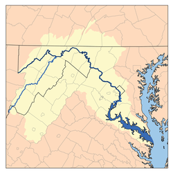
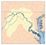
- Potomac RiverPotomac RiverThe Potomac River flows into the Chesapeake Bay, located along the mid-Atlantic coast of the United States. The river is approximately long, with a drainage area of about 14,700 square miles...
- Hull CreekHull CreekHull Creek is a tributary of the tidal portion of the Potomac River in Northumberland County in Virginia's Northern Neck....
- Coan RiverCoan RiverThe Coan River is a river in Virginia's Northern Neck region. It is a tributary of the Potomac River. It flows from its source in Heathsville through Northumberland County and into the Potomac between Lewisetta and Walnut Point....
- Yeocomico RiverYeocomico RiverThe Yeocomico River is a tidal tributary of the southern portion of the Potomac River in Virginia's Northern Neck. The Yeocomico forms the boundary between Westmoreland and Northumberland counties...
- Northwest Yeocomico RiverNorthwest Yeocomico RiverThe Northwest Yeocomico River is a tidal tributary of the Yeocomico River in the U.S. state of Virginia. The Yeocomico River system is a tidal branch of the Potomac River.-References:*USGS Hydrologic Unit Map - State of Virginia...
- South Yeocomico RiverSouth Yeocomico RiverThe South Yeocomico River is a tidal river in the U.S. state of Virginia. It is an arm of the Yeocomico River, itself an inlet from the Potomac River.-References:*USGS Hydrologic Unit Map - State of Virginia...
- West Yeocomico RiverWest Yeocomico RiverThe West Yeocomico River is a tidal river in the U.S. state of Virginia. It is an arm of the Yeocomico River, itself a branch from the Potomac River....
- Northwest Yeocomico River
- Lower Machodoc Creek
- Nomini Creek
- Popes Creek
- Mattox CreekMattox CreekMattox Creek is a tributary of the Potomac River in the Washington District of Westmoreland County, Virginia, near the colonial stagecoach stop of Oak Grove. The creek is long, and the lower of the creek is navigable...
- Rosier Creek
- Upper Machodoc Creek
- Potomac CreekPotomac CreekPotomac Creek is a tidal tributary of the Potomac River in King George and Stafford counties, Virginia. Potomac Creek's source lies between the communities of Glendie and Paynes Corner in Stafford County. It empties into the Potomac River at Marlboro Point...
- Accokeek CreekAccokeek CreekAccokeek Creek is a tidal tributary of Potomac Creek, itself a tributary of the Potomac River, in Stafford County, Virginia, United States. From it headwaters to its mouth, Accokeek Creek is in total length.-Nomenclature:...
- Accokeek Creek
- Aquia CreekAquia CreekAquia Creek is a tributary of the tidal segment of the Potomac River and is located in northern Virginia. The creek's headwaters lie in southeastern Fauquier County, and it empties into the Potomac at Brent Point in Stafford County, south of Washington, D.C....
- Chopawamsic CreekChopawamsic CreekChopawamsic Creek is a tributary of the Potomac River in Prince William and Stafford counties, Virginia. Chopawamsic Creek is formed by the confluence of the North and South Branches of Chopawamsic Creek and empties into the Potomac River south of Quantico at the Marine Corps Base Quantico's Air...
- Quantico CreekQuantico CreekQuantico Creek is a tidal tributary of the Potomac River in eastern Prince William County, Virginia. Quantico Creek rises southeast of Independent Hill, flows through Prince William Forest Park and Dumfries and empties into the Potomac at Possum Point....
- Neabsco CreekNeabsco CreekNeabsco Creek is a tributary of the lower tidal segment of the Potomac River in eastern Prince William County, Virginia. The Neabsco Creek watershed covers about...
- Occoquan RiverOccoquan RiverThe Occoquan River is a tributary of the Potomac River in northern Virginia, in the mid-Atlantic region of the United States. The river is long, and its watershed covers about . It is formed by the confluence of Broad Run and Cedar Run in Prince William County; Bull Run enters it east-southeast of...
- Bull RunBull Run (Occoquan River)Bull Run is a free-flowing tributary stream of the Potomac River that originates from a spring in the Bull Run Mountains in Loudoun County, Virginia, and flows south to the Occoquan River...
- Popes Head Creek
- Cub Run
- Little Bull Run
- Cedar RunCedar Run (Occoquan River)Cedar Run is a tributary of the Occoquan River in the U.S. state of Virginia....
- Broad RunBroad Run (Occoquan River)Broad Run is a tributary of the Occoquan River in the U.S. state of Virginia....
- Kettle Run
- Bull Run
- Pohick CreekPohick CreekPohick Creek is a tributary stream of the Potomac River in Fairfax County in the U.S. state of Virginia. It takes its name from the Pohick Native American tribe once prevalent in the area....
- Accotink CreekAccotink CreekAccotink Creek is a tributary stream of the Potomac River in Fairfax County, Virginia, in the United States. At Springfield, Accotink Creek is dammed to create Lake Accotink. The stream empties into the Potomac at Gunston Cove's Accotink Bay, to the west of Fort Belvoir.-External links:**...
- Dogue CreekDogue CreekDogue Creek is an tributary of the Potomac River in Fairfax County, Virginia, named for the Doeg Indians. The lower of the creek form a tidal embayment of the Potomac to the east of Fort Belvoir.-Variant names:...
- Little Hunting CreekLittle Hunting CreekLittle Hunting Creek is a primarily tidal tributary of the Potomac River located in Fairfax County, Virginia, USA, not to be confused with Hunting Creek farther north...
- Hunting CreekHunting CreekHunting Creek is a cove and tributary stream of the Potomac River between the City of Alexandria and Fairfax County in Virginia. It is formed by the confluence of Cameron Run and Hooff Run. The community of Huntington takes its name from the creek. Jones Point forms the north side. Dyke Marsh is...
- Cameron RunCameron RunCameron Run is a tributary stream of the Potomac River, located in the U.S. state of Virginia. A third-order stream, it is formed by the confluence of Backlick Run and Holmes Run. It flows eastward from Alexandria and forms the border between Fairfax County and Alexandria before opening into...
- Cameron Run
- Four Mile RunFour Mile RunFour Mile Run is a stream in northern Virginia that starts near Interstate 66, at Gordon Avenue in Fairfax County and proceeds southeast through Falls Church to Arlington County in the U.S. state of Virginia...
- Pimmit RunPimmit RunPimmit Run is a stream in northern Virginia that runs from Fairfax County to the Potomac River at Chain Bridge in the Arlingwood neighborhood of Arlington.Pimmit Run forms south of Leesburg Pike in Pimmit Hills...
- Difficult RunDifficult RunDifficult Run is a tributary stream of the Potomac River in northern Virginia in the United States. The term "run" for "stream" is common usage in this part of Virginia and throughout the mid-Atlantic region; another "run" is better known in American Civil War history: Bull Run. Difficult Run...
- Sugarland Run
- Broad Run
- Goose CreekGoose Creek (Potomac River)Goose Creek is a tributary of the Potomac River in Fauquier and Loudoun counties in northern Virginia. It comprises the principal drainage system for the Loudoun Valley.-Course:...
- Little RiverLittle River (Goose Creek)Little River is a tributary stream of Goose Creek in Fauquier and Loudoun counties in northern Virginia. Via Goose Creek, it is a tributary of the Potomac River....
- North Fork Goose Creek
- Beaverdam Creek
- Little River
- Catoctin CreekCatoctin Creek (Virginia)Catoctin Creek is a tributary of the Potomac River in Loudoun County, Virginia, with a watershed of . Agricultural lands make up 67 percent and forests 30 percent of Catoctin Creek's watershed...
- North Fork Catoctin CreekCatoctin Creek (Virginia)Catoctin Creek is a tributary of the Potomac River in Loudoun County, Virginia, with a watershed of . Agricultural lands make up 67 percent and forests 30 percent of Catoctin Creek's watershed...
- South Fork Catoctin CreekCatoctin Creek (Virginia)Catoctin Creek is a tributary of the Potomac River in Loudoun County, Virginia, with a watershed of . Agricultural lands make up 67 percent and forests 30 percent of Catoctin Creek's watershed...
- North Fork Catoctin Creek
- Hull Creek
-
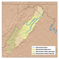
- Shenandoah RiverShenandoah RiverThe Shenandoah River is a tributary of the Potomac River, long with two forks approximately long each, in the U.S. states of Virginia and West Virginia...
- North Fork Shenandoah River
- Passage CreekPassage CreekPassage Creek is a tributary stream of the North Fork Shenandoah River in Fort Valley, Virginia. For most of its length it flows through a rural valley between the two spine-like ridges of Massanutten Mountain, then exits the valley by cutting a narrow gorge through the northeast end of the...
- Cedar CreekCedar Creek (North Fork Shenandoah River)Cedar Creek is a tributary stream of the North Fork Shenandoah River in northern Virginia in the United States. It forms the majority of the boundary between Frederick and Shenandoah counties...
- Stony Creek
- Mill Creek
- Smith CreekSmith Creek (Virginia)Smith Creek is a tributary stream of the North Fork of the Shenandoah River in the Shenandoah Valley of Virginia. Its watershed comprises within Shenandoah and Rockingham counties on the western slope of the Massanutten Mountain ridge...
- Linville Creek
- Shoemaker RiverShoemaker RiverThe Shoemaker River is an river in the U.S. state of Virginia. It is a tributary of the North Fork Shenandoah River in Rockingham County, flowing along the western base of Little North Mountain....
- Little Dry RiverLittle Dry RiverThe Little Dry River is a tributary of the North Fork Shenandoah River in the U.S. state of Virginia. It rises in Rockingham County just east of the Virginia-West Virginia border near the crest of Shenandoah Mountain and flows east, joining the North Fork just west of the village of Fulks...
- German RiverGerman RiverThe German River is the principal tributary of the North Fork of the Shenandoah River, flowing for in the U.S. state of Virginia. The river originates in northern Rockingham County, just east of the West Virginia border, in the George Washington National Forest, near the crest of Shenandoah...
- Cold Spring RiverCold Spring RiverThe Cold Spring River is a mountain stream in Rockingham County in the U.S. state of Virginia. It is a tributary of the German River, the principal source of the North Fork Shenandoah River. Via the Shenandoah River, the Cold Spring River is part of the Potomac River watershed.-References:*USGS...
- Cold Spring River
- Passage Creek
- South Fork Shenandoah River
- Hawksbill Creek
- South RiverSouth River (South Fork Shenandoah River)The South River is one of the two main tributaries of the South Fork of the Shenandoah River. It begins south of Staunton, Virginia, and flows northward to Port Republic, where it merges with the North River to form the South Fork...
- Back Creek
- North RiverNorth River (South Fork Shenandoah River)The North River is a river in the mountains and Shenandoah Valley of northern Virginia, the United States. It joins the South River at Port Republic to form the South Fork Shenandoah River....
- Middle RiverMiddle River (Virginia)The Middle River is a river in the U.S. state of Virginia. Flowing entirely within Augusta County, the Middle River joins the North River, which in turn meets the South River at Port Republic to form the South Fork Shenandoah River.-References:...
- Christians CreekChristians CreekChristians Creek is a stream in Augusta County in the U.S. state of Virginia. It is a tributary of the Middle River, part of the Shenandoah River system flowing to the Potomac River.-References:*USGS Hydrologic Unit Map - State of Virginia...
- Christians Creek
- Naked Creek
- Cooks Creek
- Dry RiverDry River (Virginia)The Dry River is a tributary of the North River in the U.S. state of Virginia. It flows entirely within Rockingham County, rising within the George Washington National Forest east of the West Virginia border and flowing south to the North River at Bridgewater...
- Muddy Creek
- Beaver Creek
- Briery Branch
- Little River
- Middle River
- North Fork Shenandoah River
- Opequon CreekOpequon CreekOpequon Creek is a tributary stream of the Potomac River. It flows into the Potomac northeast of Martinsburg in Berkeley County, West Virginia, and its source lies northwest of the community of Opequon at the foot of Great North Mountain in Frederick County, Virginia...
- Mill CreekMill Creek (Opequon Creek)Mill Creek is a tributary of Opequon Creek, belonging to the Potomac River and Chesapeake Bay watersheds, located in Berkeley County in West Virginia's Eastern Panhandle...
- Abrams CreekAbrams CreekAbrams Creek is an tributary stream of Opequon Creek in Frederick County and the independent city of Winchester in Virginia. Abrams Creek rises north of Round Hill and flows in a southeasterly direction through Winchester. From Winchester, Abrams Creek flows east into Opequon Creek...
- Mill Creek
- Back CreekBack Creek (Potomac River)Back Creek is a tributary of the Potomac River that flows north from Frederick County, Virginia, to Berkeley County in West Virginia's Eastern Panhandle. Back Creek originates along Frederick County's border with Hampshire County, West Virginia, at Farmer's Gap in the Great North Mountain. Its...
- Hogue CreekHogue CreekHogue Creek is a tributary stream of Back Creek in Frederick County, Virginia. Hogue Creek rises on Great North Mountain and flows into Back Creek at Graves Hill.-Tributaries:Tributary streams are listed from headwaters to mouth.*Bucher Run...
- Isaacs CreekIsaacs Creek (Back Creek)Isaacs Creek is a tributary stream of Back Creek in Frederick County, Virginia. Isaacs Creek rises on Timber Ridge at the boundary line with Hampshire County, West Virginia, and flows into Back Creek at Grave Hill shortly before Back Creek's confluence with Hogue Creek...
- Hogue Creek
- Sleepy CreekSleepy CreekSleepy Creek is a tributary of the Potomac River in the United States, belonging to the Chesapeake Bay's watershed. Sleepy Creek's source lies near the Hampshire County, West Virginia border at Good, north of State Route 127 in Frederick County, Virginia...
- South Branch Potomac River
- South Fork South Branch Potomac River
- North Fork South Branch Potomac River
- Laurel Fork
- Shenandoah River
- Little Wicomico RiverLittle Wicomico RiverThe Little Wicomico River is a river in the United States state of Virginia. The river, mostly tidal, lows into Chesapeake Bay at the junction of the south shore of the Potomac River, which is also the Maryland-Virginia boundary, with Chesapeake Bay....
- Great Wicomico RiverGreat Wicomico RiverThe Great Wicomico River is a river in the U.S. state of Virginia, located approximately northeast of Richmond. In 1864, during the American Civil War, one of the torpedo boats of Admiral David Dixon Porter's fleet ran into the Great Wicomico River and was captured.-Geography:The Great Wicomico...
- Rappahannock RiverRappahannock RiverThe Rappahannock River is a river in eastern Virginia, in the United States, approximately in length. It traverses the entire northern part of the state, from the Blue Ridge Mountains in the west, across the Piedmont, to the Chesapeake Bay, south of the Potomac River.An important river in American...
- Corrotoman RiverCorrotoman RiverThe Corrotoman River is a small river on the northern banks of the Rappahannock River in Virginia, United States. The Corrotoman River is about 8 miles from the mouth of the Rappahannock River, which drains into the Chesapeake Bay. The Corrotoman River cuts into the Northern Neck; a region of...
- Totuskey Creek
- Piscataway CreekPiscataway Creek (Virginia)Piscataway Creek is a tributary of the Rappahannock River in eastern Virginia, in the United States, approximately in length. It is fed by the Sturgeon Swamp and Mussel Swamp, lowlands near US Route 360 on the Middle Peninsula, and empties into the Rappahannock River three miles downstream from...
- Hoskins Creek
- Cat Point Creek
- Occupacia Creek
- Rapidan RiverRapidan RiverThe Rapidan River, flowing through north-central Virginia in the United States, is the largest tributary of the Rappahannock River. The two rivers converge just west of the city of Fredericksburg...
- Mine Run
- Robinson River
- Rose RiverRose RiverThe Rose River is an river in the U.S. state of Virginia. Rising south of Hawksbill Mountain, the highest point in Shenandoah National Park, the river flows southeast to its junction near Syria, Virginia, with the Robinson River, a tributary of the Rapidan River and part of the Rappahannock River...
- Rose River
- South RiverSouth River (Rapidan River)The South River is a river in the U.S. state of Virginia. Rising northeast of Swift Run Gap in Shenandoah National Park, the river flows southeast to the Rapidan River near Burtonville. It is part of the Rappahannock River watershed.-References:...
- Conway RiverConway River (Virginia)The Conway River is a river in the U.S. state of Virginia. Rising near the triple junction of Madison, Greene and Page counties at the crest of Shenandoah National Park, the river flows south, then southeast to the Rapidan River northwest of Burtonville. The river is part of the Rappahannock...
- Staunton RiverStaunton River (Rapidan River)The Staunton River is a stream in the U.S. state of Virginia. Flowing entirely within Shenandoah National Park, it is a tributary of the Rapidan River and part of the Rappahannock River watershed.-References:...
- Mountain Run
- Hazel RiverHazel RiverThe Hazel River is a tributary of the Rappahannock River in northern Virginia in the United States. Via the Rappahannock, it is part of the Chesapeake Bay watershed. It rises in Shenandoah National Park and flows generally eastwardly through Rappahannock and Culpeper counties. It joins the...
- Thornton RiverThornton RiverThe Thornton River is a river in the US state of Virginia. It rises at Thornton Gap in Shenandoah National Park and flows east through Rappahannock County, running parallel to U.S. Route 211 until it reaches the town of Sperryville...
- Rush RiverRush River (Virginia)The Rush River is a river in the U.S. state of Virginia. It rises in the northern part of Shenandoah National Park and flows southeast to the Thornton River at Rock Mills. Via the Thornton and Hazel rivers, it is part of the Rappahannock River watershed....
- Covington RiverCovington RiverThe Covington River is a river in the U.S. state of Virginia. The river rises at the eastern foot of the Blue Ridge Mountains in Rappahannock County and flows southeast to the Rush River just north of that river's confluence with the Thornton River...
- Covington River
- Piney RiverPiney River (Thornton River)The Piney River is an river in the U.S. state of Virginia. Rising in the northern part of Shenandoah National Park, it is a tributary of the Thornton River, and via the Hazel and Rappahannock rivers is part of the Chesapeake Bay watershed....
- Rush River
- Hughes RiverHughes River (Virginia)The Hughes River is a river in Madison, Rappahannock, and Culpeper counties in the U.S. state of Virginia. The river rises on the east slope of Stony Man mountain in Shenandoah National Park and flows southeast past the village of Nethers to join the Hazel River west of Boston, Virginia...
- Thornton River
- Jordan RiverJordan River (Virginia)The Jordan River is a headwater tributary of the Rappahannock River in northern Virginia in the United States. It rises in Shenandoah National Park and flows for its entire length in northern Rappahannock County. The river flows generally eastwardly and joins the Rappahannock River from the west....
- Corrotoman River
- Piankatank RiverPiankatank RiverThe Piankatank River is a river in the U.S. state of Virginia. Located on the Middle Peninsula, between the Rappahannock and York rivers, it was the site of numerous actions during the American Civil War....
- Dragon SwampDragon SwampDragon Swamp, also known as Dragon Run, is a stream in the U.S. state of Virginia, flowing through King and Queen, Essex, Middlesex, and Gloucester counties. It is the main freshwater tributary of the Piankatank River.-References:...
- Dragon Swamp
- East RiverEast River (Virginia)The East River is an , primarily tidal river located in Mathews County in the Middle Peninsula region of Virginia. It flows into Mobjack Bay, which in turn empties into the Chesapeake Bay....
- North RiverNorth River (Mobjack Bay)The North River is a tidal river in the U.S. state of Virginia. It is an arm of Mobjack Bay, itself part of Chesapeake Bay. The North River forms the boundary between Mathews and Gloucester counties....
- Ware RiverWare River (Virginia)The Ware River is a tidal river in the U.S. state of Virginia. It is an arm of Mobjack Bay, part of the Chesapeake Bay estuary system....
- Severn RiverSevern River (Virginia)The Severn River is a tidal river in the United States state of Virginia. It is a tributary of Mobjack Bay, which is an arm of Chesapeake Bay.-References:*USGS Hydrologic Unit Map - State of Virginia...
- York RiverYork River (Virginia)The York River is a navigable estuary, approximately long, in eastern Virginia in the United States. It ranges in width from at its head to near its mouth on the west side of Chesapeake Bay. Its watershed drains an area including portions of 17 counties of the coastal plain of Virginia north...
- Perrin RiverPerrin RiverThe Perrin River is a tidal river in the U.S. state of Virginia. It is a small inlet on the north shore of the York River near that river's mouth at Chesapeake Bay.-References:*USGS Hydrologic Unit Map - State of Virginia...
- Queen Creek
- Poropotank RiverPoropotank RiverThe Poropotank River is a river in the U.S. state of Virginia. It is a tributary of the York River and forms part of the boundary between King and Queen and Gloucester counties.-References:*USGS Hydrologic Unit Map - State of Virginia...
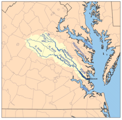
- Mattaponi RiverMattaponi RiverThe Mattaponi River is a tributary of the York River estuary in eastern Virginia in the United States.It rises as four streams in Spotsylvania County, each of which is given a shorter piece of the Mattaponi's name:...
- Maracossic Creek
- South RiverSouth River (Mattaponi River)The South River is a river in Caroline County in the U.S. state of Virginia. It is a tributary of the Mattaponi River.Rising at the boundary between Caroline County and Spotsylvania County, the South River flows east, passing under U.S. Route 1 and Interstate 95, joining the Mattaponi north of...
- Motto RiverMotto RiverThe Motto River is an river in Spotsylvania and Caroline counties in the U.S. state of Virginia. It is a tributary of the South River, and via the Mattaponi and York rivers is part of the Chesapeake Bay watershed.-References:...
- Motto River
- Matta River
- Mat RiverMattaponi RiverThe Mattaponi River is a tributary of the York River estuary in eastern Virginia in the United States.It rises as four streams in Spotsylvania County, each of which is given a shorter piece of the Mattaponi's name:...
- Ta River
- Mat River
- Poni River
- Po River
- Ni River
- Pamunkey RiverPamunkey RiverThe Pamunkey River is a tributary of the York River, about long, in eastern Virginia in the United States. Via the York River it is part of the watershed of Chesapeake Bay.-Course:...
- South Anna RiverSouth Anna RiverThe South Anna River is a principal tributary of the Pamunkey River, about long, in central Virginia in the United States. Via the Pamunkey and York rivers, it is part of the watershed of Chesapeake Bay....
- Newfound RiverNewfound River (Virginia)The Newfound River is a tributary of the South Anna River in east-central Virginia in the United States. Via the South Anna, Pamunkey and York rivers, it is part of the watershed of Chesapeake Bay....
- Taylors Creek
- Newfound River
- North Anna RiverNorth Anna RiverThe North Anna River is a principal tributary of the Pamunkey River, about long, in central Virginia in the United States. Via the Pamunkey and York rivers, it is part of the watershed of Chesapeake Bay...
- Little RiverLittle River (North Anna River)The Little River is a river in Louisa and Hanover counties in the U.S. state of Virginia. It is a tributary of the North Anna River, and via the North Anna, Pamunkey, and York rivers is part of the Chesapeake Bay watershed.-References:...
- Pamunkey CreekPamunkey CreekPamunkey Creek is a river in Orange and Spotsylvania counties in the U.S. state of Virginia. It is a tributary of the North Anna River.The creek is formed by the confluence of smaller branches that rise in the town of Orange, Virginia, then flows southeast across the Virginia Piedmont. It joins...
- Little River
- South Anna River
- Perrin River
- Poquoson RiverPoquoson RiverThe Poquoson River is an , mostly tidal river in the state of Virginia. The river is an arm of Chesapeake Bay, entering just south of the mouth of the York River....
- Back RiverBack River (Virginia)The Back River is an estuarine inlet of the Chesapeake Bay between the independent cities of Hampton and Poquoson in the Hampton Roads area of southeastern Virginia. Formed by the confluence of the Northwest and Southwest Branches, and at just over two miles long, the Back River is a breeding...
- Harris RiverHarris RiverThe Harris River is a tidal river within the city of Hampton in the U.S. state of Virginia. It is a southerly arm of the Back River, an inlet of Chesapeake Bay.-References:*USGS Hydrologic Unit Map - State of Virginia...
- Harris River
- Hampton RoadsHampton RoadsHampton Roads is the name for both a body of water and the Norfolk–Virginia Beach metropolitan area which surrounds it in southeastern Virginia, United States...
- Hampton RiverHampton RiverThe Hampton River is a tidal estuary which empties into Hampton Roads near its mouth. Hampton Roads in turn empties into the southern end of Chesapeake Bay in southeast Virginia in the United States...
- Elizabeth RiverElizabeth River (Virginia)The Elizabeth River is a tidal estuary forming an arm of Hampton Roads harbor at the southern end of Chesapeake Bay in southeast Virginia in the United States. It is located along the southern side of the mouth of the James River, between the cities of Portsmouth and Norfolk...
- Lafayette RiverLafayette RiverThe Lafayette River, earlier known as Tanner's Creek, is a tidal estuary which empties into the Elizabeth River just south of Sewell's Point near its mouth at Hampton Roads, which in turn empties into the southern end of Chesapeake Bay in southeast Virginia in the United States...
- Western Branch Elizabeth RiverWestern Branch Elizabeth RiverThe Western Branch Elizabeth River is a tidal river located in the city of Portsmouth, Virginia, in the United States. It is a tributary of the Elizabeth River, part of the harbor of Hampton Roads in southeastern Virginia....
- Eastern Branch Elizabeth RiverEastern Branch Elizabeth RiverThe Eastern Branch Elizabeth River is a tidal river in the Hampton Roads area of the U.S. state of Virginia. The river flows from east to west, starting in Virginia Beach. At its crossing by Interstate 64 it becomes the boundary between Virginia Beach and the city of Norfolk, and farther west it...
- Indian RiverIndian River (Virginia)The Indian River is a , primarily tidal river located entirely within the city of Chesapeake, Virginia, in the United States. It is a tributary of the Eastern Branch Elizabeth River, leading to the harbor of Hampton Roads....
- Indian River
- Southern Branch Elizabeth RiverSouthern Branch Elizabeth RiverThe Southern Branch Elizabeth River is a , primarily tidal river in the U.S. state of Virginia. It flows from south to north through the city of Chesapeake and forms the boundary between the cities of Portsmouth and Chesapeake for its northernmost . It is a tributary of the Elizabeth River,...
- Lafayette River
- Hampton River
-
- James RiverJames RiverThe James River may refer to:Rivers in the United States and their namesakes* James River * James River , North Dakota, South Dakota* James River * James River * James River...
- Hoffler CreekHoffler CreekHoffler Creek is a tidal inlet of the James River on its southern side in Hampton Roads. It forms the boundary between the cities of Portsmouth and Suffolk, Virginia. The mouth of the creek is between the Nansemond River to the west and Craney Island to the east.Normally a tranquil salt marsh, the...
- Nansemond RiverNansemond RiverThe Nansemond River is a tributary of the James River in the U.S. state of Virginia. The Nansemond River Bridge crosses the river near its mouth. Both it and the former State Route 125 bridge, demolished in 2008, were once toll bridges. The river begins at the outlet of Lake Meade north of...
- Knotts CreekKnotts CreekKnotts Creek is a tidal inlet on the south shore of the Nansemond River in the city of Suffolk, Virginia, in the United States....
- Bennett Creek
- Knotts Creek
- Chuckatuck CreekChuckatuck CreekChuckatuck Creek is a tributary of the James River in the U.S. state of Virginia. The creek rises in Isle of Wight County and flows southeast to Chuckatuck in the city of Suffolk, where it turns northeast as it passes under State Route 10/State Route 32...
- Brewers Creek
- Pagan RiverPagan RiverThe Pagan River is a tributary of the James River located in Isle of Wight County, Virginia. The historic town of Smithfield is located on the banks of this river....
- Warwick RiverWarwick River (Virginia)The Warwick River is a tidal estuary which empties into the James River a few miles from Hampton Roads at the southern end of Chesapeake Bay in southeast Virginia in the United States...
- Lawnes Creek
- Skiffes Creek
- College CreekCollege CreekCollege Creek is located in James City County in the Virginia Peninsula area of the Hampton Roads region of southeastern Virginia in the United States...
- Grays Creek
- Chickahominy RiverChickahominy RiverThe Chickahominy is an river in the eastern portion of the U.S. state of Virginia. The river rises about northwest of Richmond and flows southeast and south to the James River...
- Diascund Creek
- Upper Chippokes Creek
- Wards Creek
- Bailey Creek
- Appomattox RiverAppomattox RiverThe Appomattox River is a tributary of the James River, approximately long, in central and eastern Virginia in the United States, named for the Appomattocs Indian tribe who lived along its lower banks in the 17th century...
- Cabin Creek
- Swift CreekSwift Creek (Virginia)Swift Creek is a river in the U.S. state of Virginia. It rises west of Richmond in Powhatan County and flows southeast, eventually forming the northern boundary of Colonial Heights, where it joins the Appomattox River.-References:...
- Namozine CreekNamozine CreekNamozine Creek is a stream in the U.S. state of Virginia. It is a tributary of the Appomattox River. Rising in Nottoway County northeast of the town of Blackstone, Namozine Creek forms the boundary between Dinwiddie County to the south and Nottoway and Amelia counties to the north for nearly...
- Deep CreekDeep Creek (Appomattox River)Deep Creek is a tributary of the Appomattox River in the U.S. state of Virginia. It rises in Nottoway County northwest of Crewe and flows northeast into Amelia County, joining the Appomattox River west of Petersburg.-References:...
- Flat CreekFlat Creek (Virginia)Flat Creek is a tributary of the Appomattox River in the U.S. state of Virginia. It rises just east of the town of Burkeville in Nottoway County and flows north into Amelia County, then northeast to join the Appomattox River northwest of Petersburg....
- Bush RiverBush River (Virginia)The Bush River is a tributary of the Appomattox River in the U.S. state of Virginia. It rises northeast of Keysville near the junction of the boundaries between Charlotte, Prince Edward, and Lunenburg counties. It flows northeast through Prince Edward County and joins the Appomattox River east of...
- Sandy RiverSandy River (Bush River)Sandy River is a tributary of the Bush River in the U.S. state of Virginia. Via the Bush River and the Appomattox River, it is part of the James River watershed...
- Sandy River
- Buffalo CreekBuffalo Creek (Appomattox River)Buffalo Creek is a tributary of the Appomattox River in the U.S. state of Virginia. Flowing entirely through Prince Edward County, it joins the Appomattox River at Farmville.-References:*USGS Hydrologic Unit Map - State of Virginia...
- Falling CreekFalling CreekFalling Creek is a tributary of the James River located near Richmond, Virginia. Approximately in length, it varies in width between at its source to several hundred feet in the Falling Creek Reservoir. Falling Creek rises in the Salisbury section of northwestern Chesterfield County and empties...
- Powhite CreekPowhite CreekPowhite Creek is an stream rising near the unincorporated community of Bon Air in Chesterfield County and flowing into the independent city of Richmond in central Virginia...
- Deep Creek
- Muddy Creek
- Willis RiverWillis RiverThe Willis River is a tributary of the James River in central Virginia in the United States. Via the James River, it is part of the watershed of Chesapeake Bay....
- Little Willis RiverLittle Willis RiverThe Little Willis River is a tributary of the Willis River in the U.S. state of Virginia. It is part of the James River watershed. It rises in Buckingham County and flows east into Cumberland County, joining the Willis River north of Farmville....
- Little Willis River
- Byrd Creek
- Rivanna RiverRivanna RiverThe Rivanna River is a tributary of the James River in central Virginia in the United States. The Rivanna's tributaries originate in the Blue Ridge Mountains; via the James River, it is part of the watershed of Chesapeake Bay....
- Mechunk Creek
- Buck Island Creek
- North Fork Rivanna RiverRivanna RiverThe Rivanna River is a tributary of the James River in central Virginia in the United States. The Rivanna's tributaries originate in the Blue Ridge Mountains; via the James River, it is part of the watershed of Chesapeake Bay....
- Lynch RiverLynch RiverThe Lynch River is a tributary of the North Fork Rivanna River in the U.S. state of Virginia. It is part of the James River watershed. It rises at the unincorporated community of Mission Home near the boundary of Shenandoah National Park and flows southeast past Shady Grove and Nortonsville to...
- Roach River
- Lynch River
- South Fork Rivanna RiverRivanna RiverThe Rivanna River is a tributary of the James River in central Virginia in the United States. The Rivanna's tributaries originate in the Blue Ridge Mountains; via the James River, it is part of the watershed of Chesapeake Bay....
- Mechums RiverMechums RiverThe Mechums River is a tributary of the South Fork of the Rivanna River in central Virginia in the United States. Via the Rivanna and James rivers, it is part of the watershed of Chesapeake Bay.-Course:...
- Moormans RiverMoormans RiverThe Moormans River is a tributary of the South Fork of the Rivanna River in central Virginia in the United States. Via the Rivanna and James rivers, it is part of the watershed of Chesapeake Bay....
- Doyles RiverDoyles RiverThe Doyles River is a tributary of the Moormans River in central Virginia in the United States. Via the Moormans, Rivanna and James rivers, it is part of the watershed of Chesapeake Bay....
- Doyles River
- Mechums River
- Slate River
- North RiverNorth River (Slate River)The North River is a tributary of the Slate River in Buckingham County in the U.S. state of Virginia. It is part of the James River watershed.-References:*USGS Hydrologic Unit Map - State of Virginia...
- North River
- Hardware RiverHardware RiverThe Hardware River is a tributary of the James River in central Virginia in the United States. Via the James River it is part of the watershed of Chesapeake Bay....
- Rockfish RiverRockfish RiverThe Rockfish River is a tributary of the James River in central Virginia in the United States. Via the James River, it is part of the watershed of Chesapeake Bay.-Course:...
- Tye RiverTye RiverThe Tye River is a tributary of the James River in central Virginia in the United States. Originating on the eastern slope of the Blue Ridge Mountains in Nelson County, and fed by the Piney and Buffalo rivers, by way of the James River it is part of the watershed of the Chesapeake Bay.Although...
- Rucker Run
- Buffalo RiverBuffalo River (Virginia)The Buffalo River is a tributary of the Tye River in the U.S. state of Virginia. It is part of the James River watershed.It rises at the eastern foot of the Blue Ridge Mountains at Forks of Buffalo along U.S. Route 60 in Amherst County, where the North and South forks of the Buffalo River converge...
- Piney River
- Little Piney RiverLittle Piney RiverThe Little Piney River is a tributary of the Piney River in Amherst County in the U.S. state of Virginia. Via the Piney and Tye rivers, it is part of the James River watershed.-References:*USGS Hydrologic Unit Map - State of Virginia...
- Little Piney River
- South Fork Tye River
- North Fork Tye River
- David Creek
- Beaver Creek
- Blackwater Creek
- Ivy Creek
- Harris Creek
- Pedlar RiverPedlar RiverThe Pedlar River is a tributary of the James River in west-central Virginia in the United States. Via the James River, it is part of the watershed of Chesapeake Bay.The Pedlar River flows for its entire length in western Amherst County...
- Maury RiverMaury RiverThe Maury River is a tributary of the James River in west-central Virginia in the United States. Via the James River, it is part of the watershed of Chesapeake Bay.The Maury flows for its entire length in Rockbridge County...
- Buffalo CreekBuffalo Creek (Maury River)Buffalo Creek is a tributary of the Maury River in Rockbridge County in the U.S. state of Virginia. It is part of the James River watershed.-References:*USGS Hydrologic Unit Map - State of Virginia...
- North Buffalo CreekNorth Buffalo CreekNorth Buffalo Creek is a tributary of Buffalo Creek in Rockbridge County in the U.S. state of Virginia. Via Buffalo Creek and the Maury River, it is part of the James River watershed.-References:*USGS Hydrologic Unit Map - State of Virginia...
- South Buffalo CreekSouth Buffalo CreekSouth Buffalo Creek is a tributary of Buffalo Creek in Botetourt and Rockbridge counties in the U.S. state of Virginia. Via Buffalo Creek and the Maury River, it is part of the James River watershed.-References:...
- North Buffalo Creek
- South RiverSouth River (Maury River)The South River is a tributary of the Maury River in the U.S. state of Virginia. It is part of the James River watershed.It rises southwest of Lofton in Augusta County, Virginia, near the western base of the Blue Ridge Mountains, and quickly receives the Saint Marys River coming out of the...
- Irish Creek
- Saint Marys RiverSaint Marys River (Virginia)The Saint Marys River is an tributary of the South River in Augusta County in the U.S. state of Virginia. By the South and Maury rivers, it is part of the James River watershed....
- Whistle Creek
- Kerrs Creek
- Hays Creek
- Little Calfpasture RiverLittle Calfpasture RiverThe Little Calfpasture River is a tributary of the Maury River in the U.S. state of Virginia. It is part of the James River watershed.The river rises east of Elliott Knob on Great North Mountain in the Allegheny Mountains of western Virginia, in Augusta County...
- Calfpasture RiverCalfpasture RiverThe Calfpasture River is a river in the U.S. state of Virginia. It flows about from its source, Gordons Peak in the Allegheny Mountains, to its confluence with the Little Calfpasture River, forming the Maury River. Via the Maury, the Calfpasture's waters flow into the James River, thence...
- Mill Creek (Calfpasture River)
- Buffalo Creek
- Cedar Creek (James River)
- Catawba Creek
- Craig CreekCraig CreekCraig Creek is an tributary of the James River in the U.S. state of Virginia. It flows through the Ridge-and-Valley Appalachians in western Virginia, passing northwest of Roanoke....
- Johns Creek
- Mill Creek (James River)
- Sinking Creek
- Cowpasture RiverCowpasture RiverThe Cowpasture River is a chief tributary of the James River in western Virginia in the United States. It is long.-Course:The Cowpasture rises in northeastern Highland County and flows generally southwestwardly, initially between Bullpasture Mountain and Shaws Ridge through a narrow valley floor...
- Stuart Run
- Bullpasture RiverBullpasture RiverThe Bullpasture River is a tributary of the Cowpasture River of Virginia in the United States.The Bullpasture River flows through Highland County, Virginia from its headwaters on the boundary between Virginia and West Virginia...
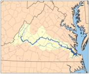
- Jackson RiverJackson River (Virginia)The Jackson River is a major tributary of the James River in the U.S. state of Virginia, flowing . The James River is formed by the confluence of the Jackson River and the Cowpasture River.-Course:...
- Potts Creek
- Dunlap CreekDunlap CreekDunlap Creek is a tributary of the Jackson River in the U.S. state of Virginia. It is part of the James River watershed.The creek forms at Earlehurst in Alleghany County, Virginia, by the confluence of Back Creek and Sweet Springs Creek, both of which rise to the southwest in Monroe County, West...
- Ogle Creek
- Cedar Creek (Jackson River)
- Back CreekBack Creek (Jackson River)Back Creek is a river in the United States state of Virginia. It is a tributary of the Jackson River, part of the James River watershed.- References :* USGS Hydrologic Unit Map - State of Virginia...
- Little Back Creek
- Hoffler Creek
- James River
- Lynnhaven RiverLynnhaven RiverThe Lynnhaven River is a tidal estuary located in the independent city of Virginia Beach, Virginia, in the United States, and flows into the Chesapeake Bay west of Cape Henry at Lynnhaven Inlet, beyond which is Lynnhaven Roads. It has a small, developed watershed covering , terminating at Lynnhaven...
Atlantic OceanAtlantic OceanThe Atlantic Ocean is the second-largest of the world's oceanic divisions. With a total area of about , it covers approximately 20% of the Earth's surface and about 26% of its water surface area...
south of Chesapeake Bay
- North Landing RiverNorth Landing RiverThe North Landing River is a river in the United States state of Virginia.-References:**USGS Hydrologic Unit Map - State of Virginia...
- Pocaty RiverPocaty River-References:**USGS Hydrologic Unit Map - State of Virginia...
- Pocaty River
- Northwest River
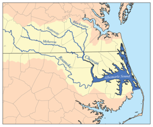
- Chowan River (NC)
- Meherrin RiverMeherrin RiverThe Meherrin River is a long river in the U.S. states of Virginia and North Carolina. It begins in central Virginia, about northwest of Emporia, and flows roughly east-southeast into North Carolina, where it joins the larger Chowan River....
- Fontaine CreekFontaine Creek-References:**USGS Hydrologic Unit Map - State of Virginia...
- Flat Rock Creek
- North Meherrin RiverNorth Meherrin RiverThe North Meherrin River is a river in the United States state of Virginia.-References:**USGS Hydrologic Unit Map - State of Virginia...
- Reedy Creek
- South Meherrin RiverSouth Meherrin RiverThe South Meherrin River is a river in the United States state of Virginia.-References:**USGS Hydrologic Unit Map - State of Virginia...
- Middle Meherrin RiverMiddle Meherrin RiverThe Middle Meherrin River is a river in the United States state of Virginia.-References:**USGS Hydrologic Unit Map - State of Virginia...
- Middle Meherrin River
- Fontaine Creek
- Somerton Creek
- Blackwater River
- Nottoway RiverNottoway RiverThe Nottoway River is in southern Virginia and northeastern North Carolina. It is part of the Chowan River system, which flows into Albemarle Sound in North Carolina.-Cities and towns:Cities and towns along the river include:* Courtland, Virginia...
- Three CreekThree Creek-References:**USGS Hydrologic Unit Map - State of Virginia...
- Rowanty CreekRowanty Creek-References:**USGS Hydrologic Unit Map - State of Virginia...
- Stony CreekStony Creek (Virginia)-References:**USGS Hydrologic Unit Map - State of Virginia...
- Sappony Creek
- Little Nottoway RiverLittle Nottoway RiverThe Little Nottoway River is a river in the United States state of Virginia.-References:**USGS Hydrologic Unit Map - State of Virginia...
- Three Creek
- Meherrin River
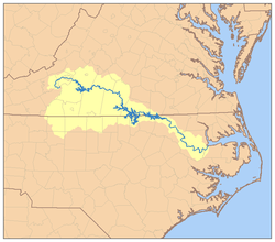
- Roanoke RiverRoanoke RiverThe Roanoke River is a river in southern Virginia and northeastern North Carolina in the United States, 410 mi long. A major river of the southeastern United States, it drains a largely rural area of the coastal plain from the eastern edge of the Appalachian Mountains southeast across the Piedmont...
(or Staunton River)- Allen Creek
- Island Creek
- Grassy Creek
- Bluestone Creek
- Little Bluestone Creek
- Dan RiverDan RiverThe Dan River flows in the U.S. states of North Carolina and Virginia. It originates in Patrick County, Virginia, and crosses the state border into Stokes County, North Carolina. It then flows into Rockingham County. From there it goes back into Virginia. It reenters North Carolina near the...
- Aarons Creek
- Hyco RiverHyco RiverThe Hyco River is a tributary of the Dan River, which is a tributary of the Roanoke River. All three rivers flow through the U.S. states of North Carolina and Virginia. In Person County, North Carolina the Hyco River is impounded by a dam, forming Hyco Lake...
- Mayo Creek
- Banister RiverBanister RiverThe Banister River is a tributary of the Dan River, about 65 mi long, in southern Virginia in the United States. Via the Dan, it is part of the watershed of the Roanoke River, which flows to the Atlantic Ocean. It rises on Brier Mountain in western Pittsylvania County and flows generally...
- Sandy CreekSandy Creek (Banister River)Sandy Creek is a river in the United States state of Virginia.-References:**USGS Hydrologic Unit Map - State of Virginia...
- Stinking RiverStinking RiverThe Stinking River is a short tributary of the Banister River in southern Virginia in the United States. Via the Banister and Dan Rivers, it is part of the watershed of the Roanoke River, which flows to the Atlantic Ocean. The Stinking River flows for its entire length in Pittsylvania...
- Sandy Creek
- Country Line Creek
- Sandy RiverSandy River (Virginia)-References:**USGS Hydrologic Unit Map - State of Virginia...
- Cascade Creek
- Smith RiverSmith River (Virginia)The Smith River is a river in the U.S. states of Virginia and North Carolina. It is a tributary of the Dan River, which it joins at Eden, North Carolina...
- Leatherwood Creek
- Mayo RiverMayo River (Dan River)The Mayo River is a tributary of the Dan River, which in turn is a tributary of the Roanoke River. All three rivers flow through the U.S. states of Virginia and North Carolina. It is named for Major William Mayo .-Course:...
- North Mayo RiverNorth Fork Mayo RiverThe North Fork Mayo River is a river in the United States state of Virginia.-References:**USGS Hydrologic Unit Map - State of Virginia...
- South Mayo RiverSouth Fork Mayo RiverThe South Fork Mayo River is a river in the United States state of Virginia.-References:**USGS Hydrologic Unit Map - State of Virginia...
- Russell Creek
- North Mayo River
- Little Dan RiverLittle Dan RiverThe Little Dan River is a river in the United States state of Virginia.-References:**USGS Hydrologic Unit Map - State of Virginia...
- Browns Dan RiverBrowns Dan RiverThe Browns Dan River is a river in the United States state of Virginia.-References:**USGS Hydrologic Unit Map - State of Virginia...
- Browns Dan River
- Difficult Creek
- Roanoke CreekRoanoke Creek-References:**USGS Hydrologic Unit Map - State of Virginia...
- Cub CreekClub Creek-References:**USGS Hydrologic Unit Map - State of Virginia...
- Falling RiverFalling River-References:**USGS Hydrologic Unit Map - State of Virginia...
- Little Falling RiverLittle Falling RiverThe Little Falling River is a river in the United States state of Virginia.-References:**USGS Hydrologic Unit Map - State of Virginia...
- Mollys Creek
- South Fork Falling River
- Little Falling River
- Straightstone Creek
- Seneca CreekSeneca River (Virginia)-References:**USGS Hydrologic Unit Map - State of Virginia...
- West Little Seneca Creek
- East Little Seneca Creek
- Otter RiverOtter River (Virginia)-References:**USGS Hydrologic Unit Map - State of Virginia...
- Big Otter RiverBig Otter RiverThe Big Otter River is a river in the United States state of Virginia.-References:**USGS Hydrologic Unit Map - State of Virginia...
- Little Otter RiverLittle Otter RiverThe Little Otter River is a river in the United States state of Virginia.-References:**USGS Hydrologic Unit Map - State of Virginia...
- Little Otter River
- Goose Creek (Roanoke River)Goose Creek (Roanoke River)Goose Creek is a river in the United States state of Virginia.-References:**USGS Hydrologic Unit Map - State of Virginia...
- Pigg RiverPigg RiverThe Pigg River is a river in south-central Virginia in the United States. It is a tributary of the Roanoke River, which flows to the Atlantic Ocean via Albemarle Sound....
- Snow Creek
- Big Chestnut Creek
- Blackwater RiverBlackwater River (Roanoke River)The Blackwater River is a river in the United States state of Virginia.-References:**USGS Hydrologic Unit Map - State of Virginia...
- Maggodee Creek
- Back Creek
- Tinker Creek
- North Fork Roanoke River
- South Fork Roanoke River
- Goose Creek (South Fork Roanoke River)
- Pee Dee River (NC)
- Yadkin River (NC)
- Ararat RiverArarat RiverThe Ararat River is a tributary of the Yadkin River in southwestern Virginia and northwestern North Carolina in the United States. Via the Yadkin it is part of the watershed of the Pee Dee River, which flows to the Atlantic Ocean....
- Stewarts Creek
- Lovills Creek
- Fisher RiverFisher River (North Carolina)The Fisher River is a tributary of the Yadkin River in northwestern North Carolina in the United States, also draining a very small portion of southwestern Virginia. Via the Yadkin it is part of the watershed of the Pee Dee River, which flows to the Atlantic Ocean...
- Ararat River
- Yadkin River (NC)
Tennessee River
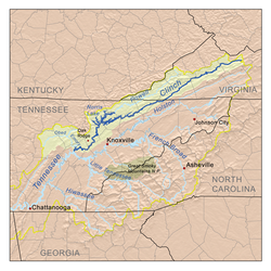
- Tennessee River (TN)
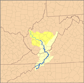
- Clinch RiverClinch RiverThe Clinch River rises in Southwest Virginia near Tazewell, Virginia and flows southwest through the Great Appalachian Valley, gathering various tributaries including the Powell River before joining the Tennessee River in East Tennessee.-Course:...
- Powell River
- Indian Creek
- Martin Creek
- Wallen Creek
- North Fork Powell River
- South Fork Powell River
- North Fork Clinch RiverNorth Fork Clinch RiverThe North Fork Clinch River is a river in the United States state of Virginia.-References:**USGS Hydrologic Unit Map - State of Virginia...
- Copper Creek
- Stock Creek
- Guest RiverGuest RiverThe Guest River is a short tributary of the Clinch River in southwestern Virginia in the United States. It is part of the watershed of the Mississippi River by way of the Clinch, Tennessee and Ohio Rivers...
- Big Creek
- Little RiverLittle River (Clinch River)The Little River is a river in the United States state of Virginia.-References:**USGS Hydrologic Unit Map - State of Virginia...
- Powell River
- Holston River (TN)
- North Fork Holston River
- Possum Creek
- Big Moccasin Creek
- Laurel Creek (North Fork Holston River)
- South Fork Holston River
- Beaver Creek
- Middle Fork Holston River
- Laurel Creek (South Fork Holston River)
- Whitetop Laurel Creek
- North Fork Holston River
- Clinch River
Ohio River
- Ohio River (KY, WV)
- Big Sandy River (KY)
- Levisa Fork
- Russell Fork
- Pound RiverPound RiverCategory: Rivers of Virginia Running through Part of Wise County Virginia, and through Dickenson County Virginia, The Pound River is a tributary of the Russell Fork in the U.S. state of Virginia. Via the Russell Fork, the Levisa Fork, the Big Sandy River, and the Ohio River, it is part of the...
- Cranes Nest River
- McClure RiverMcClure RiverThe McClure River is a tributary of the Russell Fork in the U.S. state of Virginia. It is located in Dickenson County in the southwestern part of the state. Via the Russell Fork, the Levisa Fork, the Big Sandy River, and the Ohio River, it is part of the Mississippi River...
- Pound River
- Home Creek
- Slate Creek
- Dismal Creek
- Russell Fork
- Tug Fork
- Knox Creek
- Dry ForkDry Fork (Tug Fork)The Dry Fork is a tributary of the Tug Fork, belonging to the Ohio River watershed. The river is located in McDowell County, West Virginia and Tazewell County, Virginia, in the United States...
- Levisa Fork
- Big Sandy River (KY)
-
- Kanawha River (WV)
- New River
- Bluestone RiverBluestone RiverThe Bluestone River is a tributary of the New River, 77 mi long, in southwestern Virginia and southern West Virginia in the United States. Via the New, Kanawha and Ohio Rivers, it is part of the watershed of the Mississippi River...
- East RiverEast River (West Virginia)The East River is a short tributary of the New River in Mercer County, West Virginia and a small portion of Giles County, Virginia, in the United States...
- Wolf CreekWolf Creek (New River)-References:**USGS Hydrologic Unit Map - State of Virginia...
- Walker CreekWalker Creek (Virginia)-References:**USGS Hydrologic Unit Map - State of Virginia...
- Little Walker Creek
- Kimberling Creek
- Sinking CreekSinking Creek (Virginia)-References:**USGS Hydrologic Unit Map - State of Virginia...
- Little River (New River)
- West Fork Little River
- Peak Creek
- Big Reed Island CreekReed Island Creek-References:**USGS Hydrologic Unit Map - State of Virginia...
- Little Reed Island Creek
- Burke Fork
- Snake Creek
- Reed CreekReed Creek (Virginia)-References:**USGS Hydrologic Unit Map - State of Virginia...
- Cripple CreekCripple Creek (Virginia)-References:**USGS Hydrologic Unit Map - State of Virginia...
- Crooked Creek
- Chestnut CreekChestnut Creek-References:**USGS Hydrologic Unit Map - State of Virginia...
- Elk Creek
- Little River (North Carolina-Virginia)
- Fox Creek
- Wilson Creek
- North Fork New River
- Helton Creek
- Big Horse Creek
- Bluestone River
- New River
- Kanawha River (WV)
Alphabetically
- Aarons Creek
- Abrams CreekAbrams CreekAbrams Creek is an tributary stream of Opequon Creek in Frederick County and the independent city of Winchester in Virginia. Abrams Creek rises north of Round Hill and flows in a southeasterly direction through Winchester. From Winchester, Abrams Creek flows east into Opequon Creek...
- Accokeek CreekAccokeek CreekAccokeek Creek is a tidal tributary of Potomac Creek, itself a tributary of the Potomac River, in Stafford County, Virginia, United States. From it headwaters to its mouth, Accokeek Creek is in total length.-Nomenclature:...
- Accotink CreekAccotink CreekAccotink Creek is a tributary stream of the Potomac River in Fairfax County, Virginia, in the United States. At Springfield, Accotink Creek is dammed to create Lake Accotink. The stream empties into the Potomac at Gunston Cove's Accotink Bay, to the west of Fort Belvoir.-External links:**...
- Allen Creek
- Appomattox RiverAppomattox RiverThe Appomattox River is a tributary of the James River, approximately long, in central and eastern Virginia in the United States, named for the Appomattocs Indian tribe who lived along its lower banks in the 17th century...
- Aquia CreekAquia CreekAquia Creek is a tributary of the tidal segment of the Potomac River and is located in northern Virginia. The creek's headwaters lie in southeastern Fauquier County, and it empties into the Potomac at Brent Point in Stafford County, south of Washington, D.C....
- Ararat RiverArarat RiverThe Ararat River is a tributary of the Yadkin River in southwestern Virginia and northwestern North Carolina in the United States. Via the Yadkin it is part of the watershed of the Pee Dee River, which flows to the Atlantic Ocean....
- Back Creek (Jackson River)Back Creek (Jackson River)Back Creek is a river in the United States state of Virginia. It is a tributary of the Jackson River, part of the James River watershed.- References :* USGS Hydrologic Unit Map - State of Virginia...
- Back Creek (Potomac River)Back Creek (Potomac River)Back Creek is a tributary of the Potomac River that flows north from Frederick County, Virginia, to Berkeley County in West Virginia's Eastern Panhandle. Back Creek originates along Frederick County's border with Hampshire County, West Virginia, at Farmer's Gap in the Great North Mountain. Its...
- Back Creek (Roanoke River)
- Back Creek (South River)
- Back RiverBack River (Virginia)The Back River is an estuarine inlet of the Chesapeake Bay between the independent cities of Hampton and Poquoson in the Hampton Roads area of southeastern Virginia. Formed by the confluence of the Northwest and Southwest Branches, and at just over two miles long, the Back River is a breeding...
- Bailey Creek
- Banister RiverBanister RiverThe Banister River is a tributary of the Dan River, about 65 mi long, in southern Virginia in the United States. Via the Dan, it is part of the watershed of the Roanoke River, which flows to the Atlantic Ocean. It rises on Brier Mountain in western Pittsylvania County and flows generally...
- Beaver Creek (James River)
- Beaver Creek (North River)
- Beaver Creek (South Fork Holston River)
- Beaverdam Creek
- Bennett Creek
- Big Chestnut Creek
- Big Creek
- Big Horse Creek
- Big Moccasin Creek
- Big Otter RiverBig Otter RiverThe Big Otter River is a river in the United States state of Virginia.-References:**USGS Hydrologic Unit Map - State of Virginia...
- Big Reed Island Creek
- Blackwater Creek
- Blackwater River (Chowan River)
- Blackwater River (Roanoke River)Blackwater River (Roanoke River)The Blackwater River is a river in the United States state of Virginia.-References:**USGS Hydrologic Unit Map - State of Virginia...
- Bluestone Creek
- Bluestone RiverBluestone RiverThe Bluestone River is a tributary of the New River, 77 mi long, in southwestern Virginia and southern West Virginia in the United States. Via the New, Kanawha and Ohio Rivers, it is part of the watershed of the Mississippi River...
- Brewers Creek
- Briery Branch
- Broad Run (Occoquan River)Broad Run (Occoquan River)Broad Run is a tributary of the Occoquan River in the U.S. state of Virginia....
- Broad Run (Potomac River)
- Browns Dan RiverBrowns Dan RiverThe Browns Dan River is a river in the United States state of Virginia.-References:**USGS Hydrologic Unit Map - State of Virginia...
- Buck Island Creek
- Buffalo Creek (Appomattox River)Buffalo Creek (Appomattox River)Buffalo Creek is a tributary of the Appomattox River in the U.S. state of Virginia. Flowing entirely through Prince Edward County, it joins the Appomattox River at Farmville.-References:*USGS Hydrologic Unit Map - State of Virginia...
- Buffalo Creek (Maury River)Buffalo Creek (Maury River)Buffalo Creek is a tributary of the Maury River in Rockbridge County in the U.S. state of Virginia. It is part of the James River watershed.-References:*USGS Hydrologic Unit Map - State of Virginia...
- Buffalo RiverBuffalo River (Virginia)The Buffalo River is a tributary of the Tye River in the U.S. state of Virginia. It is part of the James River watershed.It rises at the eastern foot of the Blue Ridge Mountains at Forks of Buffalo along U.S. Route 60 in Amherst County, where the North and South forks of the Buffalo River converge...
- Bull RunBull Run (Occoquan River)Bull Run is a free-flowing tributary stream of the Potomac River that originates from a spring in the Bull Run Mountains in Loudoun County, Virginia, and flows south to the Occoquan River...
- Bullpasture RiverBullpasture RiverThe Bullpasture River is a tributary of the Cowpasture River of Virginia in the United States.The Bullpasture River flows through Highland County, Virginia from its headwaters on the boundary between Virginia and West Virginia...
- Burke Fork
- Bush RiverBush River (Virginia)The Bush River is a tributary of the Appomattox River in the U.S. state of Virginia. It rises northeast of Keysville near the junction of the boundaries between Charlotte, Prince Edward, and Lunenburg counties. It flows northeast through Prince Edward County and joins the Appomattox River east of...
- Byrd Creek
- Cabin Creek
- Cameron RunCameron RunCameron Run is a tributary stream of the Potomac River, located in the U.S. state of Virginia. A third-order stream, it is formed by the confluence of Backlick Run and Holmes Run. It flows eastward from Alexandria and forms the border between Fairfax County and Alexandria before opening into...
- Cascade Creek
- Catawba Creek
- Catoctin CreekCatoctin Creek (Virginia)Catoctin Creek is a tributary of the Potomac River in Loudoun County, Virginia, with a watershed of . Agricultural lands make up 67 percent and forests 30 percent of Catoctin Creek's watershed...
- Calfpasture RiverCalfpasture RiverThe Calfpasture River is a river in the U.S. state of Virginia. It flows about from its source, Gordons Peak in the Allegheny Mountains, to its confluence with the Little Calfpasture River, forming the Maury River. Via the Maury, the Calfpasture's waters flow into the James River, thence...
- Cat Point Creek
- Cedar Creek (Jackson River)
- Cedar Creek (James River)
- Cedar Creek (North Fork Shenandoah River)Cedar Creek (North Fork Shenandoah River)Cedar Creek is a tributary stream of the North Fork Shenandoah River in northern Virginia in the United States. It forms the majority of the boundary between Frederick and Shenandoah counties...
- Cedar Run (Occoquan River)Cedar Run (Occoquan River)Cedar Run is a tributary of the Occoquan River in the U.S. state of Virginia....
- Chickahominy RiverChickahominy RiverThe Chickahominy is an river in the eastern portion of the U.S. state of Virginia. The river rises about northwest of Richmond and flows southeast and south to the James River...
- Chopawamsic CreekChopawamsic CreekChopawamsic Creek is a tributary of the Potomac River in Prince William and Stafford counties, Virginia. Chopawamsic Creek is formed by the confluence of the North and South Branches of Chopawamsic Creek and empties into the Potomac River south of Quantico at the Marine Corps Base Quantico's Air...
- Chestnut CreekChestnut Creek-References:**USGS Hydrologic Unit Map - State of Virginia...
- Christians CreekChristians CreekChristians Creek is a stream in Augusta County in the U.S. state of Virginia. It is a tributary of the Middle River, part of the Shenandoah River system flowing to the Potomac River.-References:*USGS Hydrologic Unit Map - State of Virginia...
- Chuckatuck CreekChuckatuck CreekChuckatuck Creek is a tributary of the James River in the U.S. state of Virginia. The creek rises in Isle of Wight County and flows southeast to Chuckatuck in the city of Suffolk, where it turns northeast as it passes under State Route 10/State Route 32...
- Clinch RiverClinch RiverThe Clinch River rises in Southwest Virginia near Tazewell, Virginia and flows southwest through the Great Appalachian Valley, gathering various tributaries including the Powell River before joining the Tennessee River in East Tennessee.-Course:...
- Coan RiverCoan RiverThe Coan River is a river in Virginia's Northern Neck region. It is a tributary of the Potomac River. It flows from its source in Heathsville through Northumberland County and into the Potomac between Lewisetta and Walnut Point....
- Cockle CreekCockle CreekCockle Creek is a stream in Chincoteague, Virginia between Chincoteague Inlet to the south and Chincoteague Bay to the north. It was the site of a naval battle during the Civil War, the Battle of Cockle Creek.-References:...
- Cold Spring RiverCold Spring RiverThe Cold Spring River is a mountain stream in Rockingham County in the U.S. state of Virginia. It is a tributary of the German River, the principal source of the North Fork Shenandoah River. Via the Shenandoah River, the Cold Spring River is part of the Potomac River watershed.-References:*USGS...
- College CreekCollege CreekCollege Creek is located in James City County in the Virginia Peninsula area of the Hampton Roads region of southeastern Virginia in the United States...
- Conway RiverConway River (Virginia)The Conway River is a river in the U.S. state of Virginia. Rising near the triple junction of Madison, Greene and Page counties at the crest of Shenandoah National Park, the river flows south, then southeast to the Rapidan River northwest of Burtonville. The river is part of the Rappahannock...
- Cooks Creek
- Copper Creek
- Corrotoman RiverCorrotoman RiverThe Corrotoman River is a small river on the northern banks of the Rappahannock River in Virginia, United States. The Corrotoman River is about 8 miles from the mouth of the Rappahannock River, which drains into the Chesapeake Bay. The Corrotoman River cuts into the Northern Neck; a region of...
- Country Line Creek
- Covington RiverCovington RiverThe Covington River is a river in the U.S. state of Virginia. The river rises at the eastern foot of the Blue Ridge Mountains in Rappahannock County and flows southeast to the Rush River just north of that river's confluence with the Thornton River...
- Cowpasture RiverCowpasture RiverThe Cowpasture River is a chief tributary of the James River in western Virginia in the United States. It is long.-Course:The Cowpasture rises in northeastern Highland County and flows generally southwestwardly, initially between Bullpasture Mountain and Shaws Ridge through a narrow valley floor...
- Craig CreekCraig CreekCraig Creek is an tributary of the James River in the U.S. state of Virginia. It flows through the Ridge-and-Valley Appalachians in western Virginia, passing northwest of Roanoke....
- Cranes Nest River
- Cripple CreekCripple Creek (Virginia)-References:**USGS Hydrologic Unit Map - State of Virginia...
- Crooked Creek
- Cub Creek
- Cub Run
- Dan RiverDan RiverThe Dan River flows in the U.S. states of North Carolina and Virginia. It originates in Patrick County, Virginia, and crosses the state border into Stokes County, North Carolina. It then flows into Rockingham County. From there it goes back into Virginia. It reenters North Carolina near the...
- David Creek
- Deep Creek (Appomattox River)Deep Creek (Appomattox River)Deep Creek is a tributary of the Appomattox River in the U.S. state of Virginia. It rises in Nottoway County northwest of Crewe and flows northeast into Amelia County, joining the Appomattox River west of Petersburg.-References:...
- Deep Creek (James River)
- Diascund Creek
- Difficult Creek
- Difficult RunDifficult RunDifficult Run is a tributary stream of the Potomac River in northern Virginia in the United States. The term "run" for "stream" is common usage in this part of Virginia and throughout the mid-Atlantic region; another "run" is better known in American Civil War history: Bull Run. Difficult Run...
- Dismal Creek
- Dogue CreekDogue CreekDogue Creek is an tributary of the Potomac River in Fairfax County, Virginia, named for the Doeg Indians. The lower of the creek form a tidal embayment of the Potomac to the east of Fort Belvoir.-Variant names:...
- Doyles RiverDoyles RiverThe Doyles River is a tributary of the Moormans River in central Virginia in the United States. Via the Moormans, Rivanna and James rivers, it is part of the watershed of Chesapeake Bay....
- Dry ForkDry Fork (Tug Fork)The Dry Fork is a tributary of the Tug Fork, belonging to the Ohio River watershed. The river is located in McDowell County, West Virginia and Tazewell County, Virginia, in the United States...
- Dry RiverDry River (Virginia)The Dry River is a tributary of the North River in the U.S. state of Virginia. It flows entirely within Rockingham County, rising within the George Washington National Forest east of the West Virginia border and flowing south to the North River at Bridgewater...
- Dunlap CreekDunlap CreekDunlap Creek is a tributary of the Jackson River in the U.S. state of Virginia. It is part of the James River watershed.The creek forms at Earlehurst in Alleghany County, Virginia, by the confluence of Back Creek and Sweet Springs Creek, both of which rise to the southwest in Monroe County, West...
- East Little Seneca Creek
- East RiverEast River (West Virginia)The East River is a short tributary of the New River in Mercer County, West Virginia and a small portion of Giles County, Virginia, in the United States...
(Giles County) - East RiverEast River (Virginia)The East River is an , primarily tidal river located in Mathews County in the Middle Peninsula region of Virginia. It flows into Mobjack Bay, which in turn empties into the Chesapeake Bay....
(Mathews County) - Eastern Branch Elizabeth RiverEastern Branch Elizabeth RiverThe Eastern Branch Elizabeth River is a tidal river in the Hampton Roads area of the U.S. state of Virginia. The river flows from east to west, starting in Virginia Beach. At its crossing by Interstate 64 it becomes the boundary between Virginia Beach and the city of Norfolk, and farther west it...
- Elizabeth RiverElizabeth River (Virginia)The Elizabeth River is a tidal estuary forming an arm of Hampton Roads harbor at the southern end of Chesapeake Bay in southeast Virginia in the United States. It is located along the southern side of the mouth of the James River, between the cities of Portsmouth and Norfolk...
- Elk Creek
- Falling CreekFalling CreekFalling Creek is a tributary of the James River located near Richmond, Virginia. Approximately in length, it varies in width between at its source to several hundred feet in the Falling Creek Reservoir. Falling Creek rises in the Salisbury section of northwestern Chesterfield County and empties...
- Falling RiverFalling River-References:**USGS Hydrologic Unit Map - State of Virginia...
- Fisher RiverFisher River (North Carolina)The Fisher River is a tributary of the Yadkin River in northwestern North Carolina in the United States, also draining a very small portion of southwestern Virginia. Via the Yadkin it is part of the watershed of the Pee Dee River, which flows to the Atlantic Ocean...
- Flat CreekFlat Creek (Virginia)Flat Creek is a tributary of the Appomattox River in the U.S. state of Virginia. It rises just east of the town of Burkeville in Nottoway County and flows north into Amelia County, then northeast to join the Appomattox River northwest of Petersburg....
- Flat Rock Creek
- Fontaine CreekFontaine Creek-References:**USGS Hydrologic Unit Map - State of Virginia...
- Four Mile RunFour Mile RunFour Mile Run is a stream in northern Virginia that starts near Interstate 66, at Gordon Avenue in Fairfax County and proceeds southeast through Falls Church to Arlington County in the U.S. state of Virginia...
- Fox Creek
- German RiverGerman RiverThe German River is the principal tributary of the North Fork of the Shenandoah River, flowing for in the U.S. state of Virginia. The river originates in northern Rockingham County, just east of the West Virginia border, in the George Washington National Forest, near the crest of Shenandoah...
- Goose Creek (Potomac River)Goose Creek (Potomac River)Goose Creek is a tributary of the Potomac River in Fauquier and Loudoun counties in northern Virginia. It comprises the principal drainage system for the Loudoun Valley.-Course:...
- Goose Creek (Roanoke River)Goose Creek (Roanoke River)Goose Creek is a river in the United States state of Virginia.-References:**USGS Hydrologic Unit Map - State of Virginia...
- Goose Creek (South Fork Roanoke River)
- Grassy Creek
- Grays Creek
- Great Wicomico RiverGreat Wicomico RiverThe Great Wicomico River is a river in the U.S. state of Virginia, located approximately northeast of Richmond. In 1864, during the American Civil War, one of the torpedo boats of Admiral David Dixon Porter's fleet ran into the Great Wicomico River and was captured.-Geography:The Great Wicomico...
- Guest RiverGuest RiverThe Guest River is a short tributary of the Clinch River in southwestern Virginia in the United States. It is part of the watershed of the Mississippi River by way of the Clinch, Tennessee and Ohio Rivers...
- Hampton RiverHampton RiverThe Hampton River is a tidal estuary which empties into Hampton Roads near its mouth. Hampton Roads in turn empties into the southern end of Chesapeake Bay in southeast Virginia in the United States...
- Hardware RiverHardware RiverThe Hardware River is a tributary of the James River in central Virginia in the United States. Via the James River it is part of the watershed of Chesapeake Bay....
- Harris Creek
- Harris RiverHarris RiverThe Harris River is a tidal river within the city of Hampton in the U.S. state of Virginia. It is a southerly arm of the Back River, an inlet of Chesapeake Bay.-References:*USGS Hydrologic Unit Map - State of Virginia...
- Hawksbill Creek
- Hays Creek
- Hazel RiverHazel RiverThe Hazel River is a tributary of the Rappahannock River in northern Virginia in the United States. Via the Rappahannock, it is part of the Chesapeake Bay watershed. It rises in Shenandoah National Park and flows generally eastwardly through Rappahannock and Culpeper counties. It joins the...
- Helton Creek
- Hogue CreekHogue CreekHogue Creek is a tributary stream of Back Creek in Frederick County, Virginia. Hogue Creek rises on Great North Mountain and flows into Back Creek at Graves Hill.-Tributaries:Tributary streams are listed from headwaters to mouth.*Bucher Run...
- Home Creek
- Hoskins Creek
- Hughes RiverHughes River (Virginia)The Hughes River is a river in Madison, Rappahannock, and Culpeper counties in the U.S. state of Virginia. The river rises on the east slope of Stony Man mountain in Shenandoah National Park and flows southeast past the village of Nethers to join the Hazel River west of Boston, Virginia...
- Hull CreekHull CreekHull Creek is a tributary of the tidal portion of the Potomac River in Northumberland County in Virginia's Northern Neck....
- Hunting CreekHunting CreekHunting Creek is a cove and tributary stream of the Potomac River between the City of Alexandria and Fairfax County in Virginia. It is formed by the confluence of Cameron Run and Hooff Run. The community of Huntington takes its name from the creek. Jones Point forms the north side. Dyke Marsh is...
- Hyco RiverHyco RiverThe Hyco River is a tributary of the Dan River, which is a tributary of the Roanoke River. All three rivers flow through the U.S. states of North Carolina and Virginia. In Person County, North Carolina the Hyco River is impounded by a dam, forming Hyco Lake...
- Indian Creek
- Indian RiverIndian River (Virginia)The Indian River is a , primarily tidal river located entirely within the city of Chesapeake, Virginia, in the United States. It is a tributary of the Eastern Branch Elizabeth River, leading to the harbor of Hampton Roads....
- Irish Creek
- Isaacs Creek
- Island Creek
- Ivy Creek
- Jackson RiverJackson River (Virginia)The Jackson River is a major tributary of the James River in the U.S. state of Virginia, flowing . The James River is formed by the confluence of the Jackson River and the Cowpasture River.-Course:...
- James RiverJames RiverThe James River may refer to:Rivers in the United States and their namesakes* James River * James River , North Dakota, South Dakota* James River * James River * James River...
- Johns Creek
- Jordan RiverJordan River (Virginia)The Jordan River is a headwater tributary of the Rappahannock River in northern Virginia in the United States. It rises in Shenandoah National Park and flows for its entire length in northern Rappahannock County. The river flows generally eastwardly and joins the Rappahannock River from the west....
- Kerrs Creek
- Kettle Run
- Kimberling Creek
- Knotts CreekKnotts CreekKnotts Creek is a tidal inlet on the south shore of the Nansemond River in the city of Suffolk, Virginia, in the United States....
- Knox Creek
- Lafayette RiverLafayette RiverThe Lafayette River, earlier known as Tanner's Creek, is a tidal estuary which empties into the Elizabeth River just south of Sewell's Point near its mouth at Hampton Roads, which in turn empties into the southern end of Chesapeake Bay in southeast Virginia in the United States...
- Laurel Creek (North Fork Holston River)
- Laurel Creek (South Fork Holston River)
- Laurel Fork
- Lawnes Creek
- Leatherwood Creek
- Levisa Fork
- Linville Creek
- Little Back Creek
- Little Bluestone Creek
- Little Bull Run
- Little Calfpasture RiverLittle Calfpasture RiverThe Little Calfpasture River is a tributary of the Maury River in the U.S. state of Virginia. It is part of the James River watershed.The river rises east of Elliott Knob on Great North Mountain in the Allegheny Mountains of western Virginia, in Augusta County...
- Little Dan RiverLittle Dan RiverThe Little Dan River is a river in the United States state of Virginia.-References:**USGS Hydrologic Unit Map - State of Virginia...
- Little Dry RiverLittle Dry RiverThe Little Dry River is a tributary of the North Fork Shenandoah River in the U.S. state of Virginia. It rises in Rockingham County just east of the Virginia-West Virginia border near the crest of Shenandoah Mountain and flows east, joining the North Fork just west of the village of Fulks...
- Little Falling RiverLittle Falling RiverThe Little Falling River is a river in the United States state of Virginia.-References:**USGS Hydrologic Unit Map - State of Virginia...
- Little Hunting CreekLittle Hunting CreekLittle Hunting Creek is a primarily tidal tributary of the Potomac River located in Fairfax County, Virginia, USA, not to be confused with Hunting Creek farther north...
- Little Nottoway RiverLittle Nottoway RiverThe Little Nottoway River is a river in the United States state of Virginia.-References:**USGS Hydrologic Unit Map - State of Virginia...
- Little Otter RiverLittle Otter RiverThe Little Otter River is a river in the United States state of Virginia.-References:**USGS Hydrologic Unit Map - State of Virginia...
- Little Piney RiverLittle Piney RiverThe Little Piney River is a tributary of the Piney River in Amherst County in the U.S. state of Virginia. Via the Piney and Tye rivers, it is part of the James River watershed.-References:*USGS Hydrologic Unit Map - State of Virginia...
- Little Reed Island Creek
- Little River (Clinch River)Little River (Clinch River)The Little River is a river in the United States state of Virginia.-References:**USGS Hydrologic Unit Map - State of Virginia...
- Little River (Goose Creek)Little River (Goose Creek)Little River is a tributary stream of Goose Creek in Fauquier and Loudoun counties in northern Virginia. Via Goose Creek, it is a tributary of the Potomac River....
- Little River (New River)
- Little River (North Anna River)Little River (North Anna River)The Little River is a river in Louisa and Hanover counties in the U.S. state of Virginia. It is a tributary of the North Anna River, and via the North Anna, Pamunkey, and York rivers is part of the Chesapeake Bay watershed.-References:...
- Little River (North Carolina-Virginia)
- Little River (North River)
- Little Walker Creek
- Little Wicomico RiverLittle Wicomico RiverThe Little Wicomico River is a river in the United States state of Virginia. The river, mostly tidal, lows into Chesapeake Bay at the junction of the south shore of the Potomac River, which is also the Maryland-Virginia boundary, with Chesapeake Bay....
- Little Willis RiverLittle Willis RiverThe Little Willis River is a tributary of the Willis River in the U.S. state of Virginia. It is part of the James River watershed. It rises in Buckingham County and flows east into Cumberland County, joining the Willis River north of Farmville....
- Lovills Creek
- Lower Machodoc Creek
- Lynch RiverLynch RiverThe Lynch River is a tributary of the North Fork Rivanna River in the U.S. state of Virginia. It is part of the James River watershed. It rises at the unincorporated community of Mission Home near the boundary of Shenandoah National Park and flows southeast past Shady Grove and Nortonsville to...
- Lynnhaven RiverLynnhaven RiverThe Lynnhaven River is a tidal estuary located in the independent city of Virginia Beach, Virginia, in the United States, and flows into the Chesapeake Bay west of Cape Henry at Lynnhaven Inlet, beyond which is Lynnhaven Roads. It has a small, developed watershed covering , terminating at Lynnhaven...
- McClure RiverMcClure RiverThe McClure River is a tributary of the Russell Fork in the U.S. state of Virginia. It is located in Dickenson County in the southwestern part of the state. Via the Russell Fork, the Levisa Fork, the Big Sandy River, and the Ohio River, it is part of the Mississippi River...
- Machipongo RiverMachipongo RiverThe Machipongo River is a river in Accomack County on the Eastern Shore of the U.S. state of Virginia.-References:*USGS Hydrologic Unit Map - State of Virginia...
- Maggodee Creek
- Maracossic Creek
- Martin Creek
- Mat RiverMattaponi RiverThe Mattaponi River is a tributary of the York River estuary in eastern Virginia in the United States.It rises as four streams in Spotsylvania County, each of which is given a shorter piece of the Mattaponi's name:...
- Matta River
- Mattaponi RiverMattaponi RiverThe Mattaponi River is a tributary of the York River estuary in eastern Virginia in the United States.It rises as four streams in Spotsylvania County, each of which is given a shorter piece of the Mattaponi's name:...
- Mattox CreekMattox CreekMattox Creek is a tributary of the Potomac River in the Washington District of Westmoreland County, Virginia, near the colonial stagecoach stop of Oak Grove. The creek is long, and the lower of the creek is navigable...
- Maury RiverMaury RiverThe Maury River is a tributary of the James River in west-central Virginia in the United States. Via the James River, it is part of the watershed of Chesapeake Bay.The Maury flows for its entire length in Rockbridge County...
- Mayo Creek
- Mayo RiverMayo River (Dan River)The Mayo River is a tributary of the Dan River, which in turn is a tributary of the Roanoke River. All three rivers flow through the U.S. states of Virginia and North Carolina. It is named for Major William Mayo .-Course:...
- Mechums RiverMechums RiverThe Mechums River is a tributary of the South Fork of the Rivanna River in central Virginia in the United States. Via the Rivanna and James rivers, it is part of the watershed of Chesapeake Bay.-Course:...
- Mechunk Creek
- Meherrin RiverMeherrin RiverThe Meherrin River is a long river in the U.S. states of Virginia and North Carolina. It begins in central Virginia, about northwest of Emporia, and flows roughly east-southeast into North Carolina, where it joins the larger Chowan River....
- Middle Fork Holston River
- Middle Meherrin RiverMiddle Meherrin RiverThe Middle Meherrin River is a river in the United States state of Virginia.-References:**USGS Hydrologic Unit Map - State of Virginia...
- Middle RiverMiddle River (Virginia)The Middle River is a river in the U.S. state of Virginia. Flowing entirely within Augusta County, the Middle River joins the North River, which in turn meets the South River at Port Republic to form the South Fork Shenandoah River.-References:...
- Mill Creek (Calfpasture River)
- Mill Creek (James River)
- Mill Creek (North Fork Shenandoah River)
- Mill Creek (Opequon Creek)Mill Creek (Opequon Creek)Mill Creek is a tributary of Opequon Creek, belonging to the Potomac River and Chesapeake Bay watersheds, located in Berkeley County in West Virginia's Eastern Panhandle...
- Mine Run
- Mollys Creek
- Moormans RiverMoormans RiverThe Moormans River is a tributary of the South Fork of the Rivanna River in central Virginia in the United States. Via the Rivanna and James rivers, it is part of the watershed of Chesapeake Bay....
- Mosquito CreekMosquito Creek (Virginia)Mosquito Creek is a stream in Chincoteague, Virginia that connects with Cockle Creek to the south and a mouth at Chincoteague Bay to the North.-History:...
- Motto RiverMotto RiverThe Motto River is an river in Spotsylvania and Caroline counties in the U.S. state of Virginia. It is a tributary of the South River, and via the Mattaponi and York rivers is part of the Chesapeake Bay watershed.-References:...
- Mountain Run
- Muddy Creek (Dry River)
- Muddy Creek (James River)
- Naked Creek
- Namozine CreekNamozine CreekNamozine Creek is a stream in the U.S. state of Virginia. It is a tributary of the Appomattox River. Rising in Nottoway County northeast of the town of Blackstone, Namozine Creek forms the boundary between Dinwiddie County to the south and Nottoway and Amelia counties to the north for nearly...
- Nansemond RiverNansemond RiverThe Nansemond River is a tributary of the James River in the U.S. state of Virginia. The Nansemond River Bridge crosses the river near its mouth. Both it and the former State Route 125 bridge, demolished in 2008, were once toll bridges. The river begins at the outlet of Lake Meade north of...
- Neabsco CreekNeabsco CreekNeabsco Creek is a tributary of the lower tidal segment of the Potomac River in eastern Prince William County, Virginia. The Neabsco Creek watershed covers about...
- New River
- Newfound RiverNewfound River (Virginia)The Newfound River is a tributary of the South Anna River in east-central Virginia in the United States. Via the South Anna, Pamunkey and York rivers, it is part of the watershed of Chesapeake Bay....
- Ni River
- Nomini Creek
- North Anna RiverNorth Anna RiverThe North Anna River is a principal tributary of the Pamunkey River, about long, in central Virginia in the United States. Via the Pamunkey and York rivers, it is part of the watershed of Chesapeake Bay...
- North Buffalo CreekNorth Buffalo CreekNorth Buffalo Creek is a tributary of Buffalo Creek in Rockbridge County in the U.S. state of Virginia. Via Buffalo Creek and the Maury River, it is part of the James River watershed.-References:*USGS Hydrologic Unit Map - State of Virginia...
- North Fork Catoctin Creek
- North Fork Clinch RiverNorth Fork Clinch RiverThe North Fork Clinch River is a river in the United States state of Virginia.-References:**USGS Hydrologic Unit Map - State of Virginia...
- North Fork Goose Creek
- North Fork Holston River
- North Fork Powell River
- North Fork Rivanna RiverRivanna RiverThe Rivanna River is a tributary of the James River in central Virginia in the United States. The Rivanna's tributaries originate in the Blue Ridge Mountains; via the James River, it is part of the watershed of Chesapeake Bay....
- North Fork Roanoke River
- North Fork Shenandoah River
- North Fork Tye River
- North Landing RiverNorth Landing RiverThe North Landing River is a river in the United States state of Virginia.-References:**USGS Hydrologic Unit Map - State of Virginia...
- North Mayo RiverNorth Mayo RiverThe North Mayo River is a river in the United States state of Virginia.-References:**USGS Hydrologic Unit Map - State of Virginia...
- North Meherrin RiverNorth Meherrin RiverThe North Meherrin River is a river in the United States state of Virginia.-References:**USGS Hydrologic Unit Map - State of Virginia...
- North River (Mobjack Bay)North River (Mobjack Bay)The North River is a tidal river in the U.S. state of Virginia. It is an arm of Mobjack Bay, itself part of Chesapeake Bay. The North River forms the boundary between Mathews and Gloucester counties....
- North River (Slate River)North River (Slate River)The North River is a tributary of the Slate River in Buckingham County in the U.S. state of Virginia. It is part of the James River watershed.-References:*USGS Hydrologic Unit Map - State of Virginia...
- North River (South Fork Shenandoah River)North River (South Fork Shenandoah River)The North River is a river in the mountains and Shenandoah Valley of northern Virginia, the United States. It joins the South River at Port Republic to form the South Fork Shenandoah River....
- Northwest River
- Northwest Yeocomico RiverNorthwest Yeocomico RiverThe Northwest Yeocomico River is a tidal tributary of the Yeocomico River in the U.S. state of Virginia. The Yeocomico River system is a tidal branch of the Potomac River.-References:*USGS Hydrologic Unit Map - State of Virginia...
- Nottoway RiverNottoway RiverThe Nottoway River is in southern Virginia and northeastern North Carolina. It is part of the Chowan River system, which flows into Albemarle Sound in North Carolina.-Cities and towns:Cities and towns along the river include:* Courtland, Virginia...
- Occoquan RiverOccoquan RiverThe Occoquan River is a tributary of the Potomac River in northern Virginia, in the mid-Atlantic region of the United States. The river is long, and its watershed covers about . It is formed by the confluence of Broad Run and Cedar Run in Prince William County; Bull Run enters it east-southeast of...
- Occupacia Creek
- Ogle Creek
- Opequon CreekOpequon CreekOpequon Creek is a tributary stream of the Potomac River. It flows into the Potomac northeast of Martinsburg in Berkeley County, West Virginia, and its source lies northwest of the community of Opequon at the foot of Great North Mountain in Frederick County, Virginia...
- Pagan RiverPagan RiverThe Pagan River is a tributary of the James River located in Isle of Wight County, Virginia. The historic town of Smithfield is located on the banks of this river....
- Pamunkey CreekPamunkey CreekPamunkey Creek is a river in Orange and Spotsylvania counties in the U.S. state of Virginia. It is a tributary of the North Anna River.The creek is formed by the confluence of smaller branches that rise in the town of Orange, Virginia, then flows southeast across the Virginia Piedmont. It joins...
- Pamunkey RiverPamunkey RiverThe Pamunkey River is a tributary of the York River, about long, in eastern Virginia in the United States. Via the York River it is part of the watershed of Chesapeake Bay.-Course:...
- Passage CreekPassage CreekPassage Creek is a tributary stream of the North Fork Shenandoah River in Fort Valley, Virginia. For most of its length it flows through a rural valley between the two spine-like ridges of Massanutten Mountain, then exits the valley by cutting a narrow gorge through the northeast end of the...
- Peak Creek
- Pedlar RiverPedlar RiverThe Pedlar River is a tributary of the James River in west-central Virginia in the United States. Via the James River, it is part of the watershed of Chesapeake Bay.The Pedlar River flows for its entire length in western Amherst County...
- Perrin RiverPerrin RiverThe Perrin River is a tidal river in the U.S. state of Virginia. It is a small inlet on the north shore of the York River near that river's mouth at Chesapeake Bay.-References:*USGS Hydrologic Unit Map - State of Virginia...
- Piankatank RiverPiankatank RiverThe Piankatank River is a river in the U.S. state of Virginia. Located on the Middle Peninsula, between the Rappahannock and York rivers, it was the site of numerous actions during the American Civil War....
- Pigg RiverPigg RiverThe Pigg River is a river in south-central Virginia in the United States. It is a tributary of the Roanoke River, which flows to the Atlantic Ocean via Albemarle Sound....
- Pimmit RunPimmit RunPimmit Run is a stream in northern Virginia that runs from Fairfax County to the Potomac River at Chain Bridge in the Arlingwood neighborhood of Arlington.Pimmit Run forms south of Leesburg Pike in Pimmit Hills...
- Piney River (Thornton River)Piney River (Thornton River)The Piney River is an river in the U.S. state of Virginia. Rising in the northern part of Shenandoah National Park, it is a tributary of the Thornton River, and via the Hazel and Rappahannock rivers is part of the Chesapeake Bay watershed....
- Piney River (Tye River)
- Piscataway CreekPiscataway Creek (Virginia)Piscataway Creek is a tributary of the Rappahannock River in eastern Virginia, in the United States, approximately in length. It is fed by the Sturgeon Swamp and Mussel Swamp, lowlands near US Route 360 on the Middle Peninsula, and empties into the Rappahannock River three miles downstream from...
- Po River
- Pocaty RiverPocaty River-References:**USGS Hydrologic Unit Map - State of Virginia...
- Pocomoke RiverPocomoke RiverThe Pocomoke River stretches approximately from southern Delaware through southeastern Maryland in the United States. At its mouth, the river is essentially an arm of Chesapeake Bay, whereas the upper river flows through a series of relatively inaccessible wetlands called the Great Cypress Swamp,...
- Pohick CreekPohick CreekPohick Creek is a tributary stream of the Potomac River in Fairfax County in the U.S. state of Virginia. It takes its name from the Pohick Native American tribe once prevalent in the area....
- Poni River
- Popes Creek
- Popes Head Creek
- Poquoson RiverPoquoson RiverThe Poquoson River is an , mostly tidal river in the state of Virginia. The river is an arm of Chesapeake Bay, entering just south of the mouth of the York River....
- Poropotank RiverPoropotank RiverThe Poropotank River is a river in the U.S. state of Virginia. It is a tributary of the York River and forms part of the boundary between King and Queen and Gloucester counties.-References:*USGS Hydrologic Unit Map - State of Virginia...
- Possum Creek
- Potomac CreekPotomac CreekPotomac Creek is a tidal tributary of the Potomac River in King George and Stafford counties, Virginia. Potomac Creek's source lies between the communities of Glendie and Paynes Corner in Stafford County. It empties into the Potomac River at Marlboro Point...
- Potomac RiverPotomac RiverThe Potomac River flows into the Chesapeake Bay, located along the mid-Atlantic coast of the United States. The river is approximately long, with a drainage area of about 14,700 square miles...
- Potts Creek
- Pound RiverPound RiverCategory: Rivers of Virginia Running through Part of Wise County Virginia, and through Dickenson County Virginia, The Pound River is a tributary of the Russell Fork in the U.S. state of Virginia. Via the Russell Fork, the Levisa Fork, the Big Sandy River, and the Ohio River, it is part of the...
- Powell River
- Powhite CreekPowhite CreekPowhite Creek is an stream rising near the unincorporated community of Bon Air in Chesterfield County and flowing into the independent city of Richmond in central Virginia...
- Quantico CreekQuantico CreekQuantico Creek is a tidal tributary of the Potomac River in eastern Prince William County, Virginia. Quantico Creek rises southeast of Independent Hill, flows through Prince William Forest Park and Dumfries and empties into the Potomac at Possum Point....
- Queen Creek
- Rapidan RiverRapidan RiverThe Rapidan River, flowing through north-central Virginia in the United States, is the largest tributary of the Rappahannock River. The two rivers converge just west of the city of Fredericksburg...
- Rappahannock RiverRappahannock RiverThe Rappahannock River is a river in eastern Virginia, in the United States, approximately in length. It traverses the entire northern part of the state, from the Blue Ridge Mountains in the west, across the Piedmont, to the Chesapeake Bay, south of the Potomac River.An important river in American...
- Reed CreekReed Creek (Virginia)-References:**USGS Hydrologic Unit Map - State of Virginia...
- Reed Island CreekReed Island Creek-References:**USGS Hydrologic Unit Map - State of Virginia...
- Reedy Creek
- Rivanna RiverRivanna RiverThe Rivanna River is a tributary of the James River in central Virginia in the United States. The Rivanna's tributaries originate in the Blue Ridge Mountains; via the James River, it is part of the watershed of Chesapeake Bay....
- Roach River
- Roanoke CreekRoanoke Creek-References:**USGS Hydrologic Unit Map - State of Virginia...
- Roanoke RiverRoanoke RiverThe Roanoke River is a river in southern Virginia and northeastern North Carolina in the United States, 410 mi long. A major river of the southeastern United States, it drains a largely rural area of the coastal plain from the eastern edge of the Appalachian Mountains southeast across the Piedmont...
(or Staunton River) - Robinson River
- Rockfish RiverRockfish RiverThe Rockfish River is a tributary of the James River in central Virginia in the United States. Via the James River, it is part of the watershed of Chesapeake Bay.-Course:...
- Rose RiverRose RiverThe Rose River is an river in the U.S. state of Virginia. Rising south of Hawksbill Mountain, the highest point in Shenandoah National Park, the river flows southeast to its junction near Syria, Virginia, with the Robinson River, a tributary of the Rapidan River and part of the Rappahannock River...
- Rosier Creek
- Rowanty CreekRowanty Creek-References:**USGS Hydrologic Unit Map - State of Virginia...
- Rucker Run
- Rush RiverRush River (Virginia)The Rush River is a river in the U.S. state of Virginia. It rises in the northern part of Shenandoah National Park and flows southeast to the Thornton River at Rock Mills. Via the Thornton and Hazel rivers, it is part of the Rappahannock River watershed....
- Russell Creek
- Russell Fork
- Saint Marys RiverSaint Marys River (Virginia)The Saint Marys River is an tributary of the South River in Augusta County in the U.S. state of Virginia. By the South and Maury rivers, it is part of the James River watershed....
- Sandy CreekSandy Creek (Banister River)Sandy Creek is a river in the United States state of Virginia.-References:**USGS Hydrologic Unit Map - State of Virginia...
- Sandy River (Bush River)Sandy River (Bush River)Sandy River is a tributary of the Bush River in the U.S. state of Virginia. Via the Bush River and the Appomattox River, it is part of the James River watershed...
- Sandy River (Dan River)Sandy River (Virginia)-References:**USGS Hydrologic Unit Map - State of Virginia...
- Sappony Creek
- Seneca CreekSeneca River (Virginia)-References:**USGS Hydrologic Unit Map - State of Virginia...
- Severn RiverSevern River (Virginia)The Severn River is a tidal river in the United States state of Virginia. It is a tributary of Mobjack Bay, which is an arm of Chesapeake Bay.-References:*USGS Hydrologic Unit Map - State of Virginia...
- Shenandoah RiverShenandoah RiverThe Shenandoah River is a tributary of the Potomac River, long with two forks approximately long each, in the U.S. states of Virginia and West Virginia...
- Shoemaker RiverShoemaker RiverThe Shoemaker River is an river in the U.S. state of Virginia. It is a tributary of the North Fork Shenandoah River in Rockingham County, flowing along the western base of Little North Mountain....
- Sinking Creek (James River)
- Sinking CreekSinking Creek (Virginia)-References:**USGS Hydrologic Unit Map - State of Virginia...
(New River) - Skiffes Creek
- Slate Creek
- Slate River
- Sleepy CreekSleepy CreekSleepy Creek is a tributary of the Potomac River in the United States, belonging to the Chesapeake Bay's watershed. Sleepy Creek's source lies near the Hampshire County, West Virginia border at Good, north of State Route 127 in Frederick County, Virginia...
- Smith CreekSmith Creek (Virginia)Smith Creek is a tributary stream of the North Fork of the Shenandoah River in the Shenandoah Valley of Virginia. Its watershed comprises within Shenandoah and Rockingham counties on the western slope of the Massanutten Mountain ridge...
- Smith RiverSmith River (Virginia)The Smith River is a river in the U.S. states of Virginia and North Carolina. It is a tributary of the Dan River, which it joins at Eden, North Carolina...
- Snake Creek
- Snow Creek
- Somerton Creek
- South Anna RiverSouth Anna RiverThe South Anna River is a principal tributary of the Pamunkey River, about long, in central Virginia in the United States. Via the Pamunkey and York rivers, it is part of the watershed of Chesapeake Bay....
- South Branch Potomac River
- South Buffalo CreekSouth Buffalo CreekSouth Buffalo Creek is a tributary of Buffalo Creek in Botetourt and Rockbridge counties in the U.S. state of Virginia. Via Buffalo Creek and the Maury River, it is part of the James River watershed.-References:...
- South Fork Catoctin Creek
- South Fork Clinch River
- South Fork Elizabeth River
- South Fork Falling River
- South Fork Holston River
- South Fork Powell River
- South Fork Rivanna RiverRivanna RiverThe Rivanna River is a tributary of the James River in central Virginia in the United States. The Rivanna's tributaries originate in the Blue Ridge Mountains; via the James River, it is part of the watershed of Chesapeake Bay....
- South Fork Roanoke River
- South Fork Shenandoah River
- South Fork South Branch Potomac River
- South Fork Tye River
- South Mayo RiverSouth Mayo RiverThe South Mayo River is a river in the United States state of Virginia.-References:**USGS Hydrologic Unit Map - State of Virginia...
- South Meherrin RiverSouth Meherrin RiverThe South Meherrin River is a river in the United States state of Virginia.-References:**USGS Hydrologic Unit Map - State of Virginia...
- South River (Mattaponi River)South River (Mattaponi River)The South River is a river in Caroline County in the U.S. state of Virginia. It is a tributary of the Mattaponi River.Rising at the boundary between Caroline County and Spotsylvania County, the South River flows east, passing under U.S. Route 1 and Interstate 95, joining the Mattaponi north of...
- South River (Maury River)South River (Maury River)The South River is a tributary of the Maury River in the U.S. state of Virginia. It is part of the James River watershed.It rises southwest of Lofton in Augusta County, Virginia, near the western base of the Blue Ridge Mountains, and quickly receives the Saint Marys River coming out of the...
- South River (Rapidan River)South River (Rapidan River)The South River is a river in the U.S. state of Virginia. Rising northeast of Swift Run Gap in Shenandoah National Park, the river flows southeast to the Rapidan River near Burtonville. It is part of the Rappahannock River watershed.-References:...
- South River (Shenandoah River)
- South Yeocomico RiverSouth Yeocomico RiverThe South Yeocomico River is a tidal river in the U.S. state of Virginia. It is an arm of the Yeocomico River, itself an inlet from the Potomac River.-References:*USGS Hydrologic Unit Map - State of Virginia...
- Southern Branch Elizabeth RiverSouthern Branch Elizabeth RiverThe Southern Branch Elizabeth River is a , primarily tidal river in the U.S. state of Virginia. It flows from south to north through the city of Chesapeake and forms the boundary between the cities of Portsmouth and Chesapeake for its northernmost . It is a tributary of the Elizabeth River,...
- Staunton River (Rapidan River)Staunton River (Rapidan River)The Staunton River is a stream in the U.S. state of Virginia. Flowing entirely within Shenandoah National Park, it is a tributary of the Rapidan River and part of the Rappahannock River watershed.-References:...
- Staunton River (or Roanoke RiverRoanoke RiverThe Roanoke River is a river in southern Virginia and northeastern North Carolina in the United States, 410 mi long. A major river of the southeastern United States, it drains a largely rural area of the coastal plain from the eastern edge of the Appalachian Mountains southeast across the Piedmont...
) - Stewarts Creek
- Stinking RiverStinking RiverThe Stinking River is a short tributary of the Banister River in southern Virginia in the United States. Via the Banister and Dan Rivers, it is part of the watershed of the Roanoke River, which flows to the Atlantic Ocean. The Stinking River flows for its entire length in Pittsylvania...
- Stock Creek
- Stony Creek (North Fork Shenandoah River)
- Stony Creek (Nottoway River)
- Straightstone Creek
- Stuart Run
- Sugarland Run
- Swift CreekSwift Creek (Virginia)Swift Creek is a river in the U.S. state of Virginia. It rises west of Richmond in Powhatan County and flows southeast, eventually forming the northern boundary of Colonial Heights, where it joins the Appomattox River.-References:...
- Ta River
- Taylors Creek
- Thornton RiverThornton RiverThe Thornton River is a river in the US state of Virginia. It rises at Thornton Gap in Shenandoah National Park and flows east through Rappahannock County, running parallel to U.S. Route 211 until it reaches the town of Sperryville...
- Three CreekThree Creek-References:**USGS Hydrologic Unit Map - State of Virginia...
- Tinker Creek
- Totuskey Creek
- Tug Fork
- Tye RiverTye RiverThe Tye River is a tributary of the James River in central Virginia in the United States. Originating on the eastern slope of the Blue Ridge Mountains in Nelson County, and fed by the Piney and Buffalo rivers, by way of the James River it is part of the watershed of the Chesapeake Bay.Although...
- Upper Chippokes Creek
- Upper Machodoc Creek
- Walker CreekWalker Creek (Virginia)-References:**USGS Hydrologic Unit Map - State of Virginia...
- Wallen Creek
- Wards Creek
- Ware RiverWare RiverThe Ware River is a river in central Massachusetts. It has two forks, the longest of which begins near Hubbardston, Massachusetts...
- Warwick RiverWarwick River (Virginia)The Warwick River is a tidal estuary which empties into the James River a few miles from Hampton Roads at the southern end of Chesapeake Bay in southeast Virginia in the United States...
- West Fork Little River
- West Little Seneca Creek
- West Yeocomico RiverWest Yeocomico RiverThe West Yeocomico River is a tidal river in the U.S. state of Virginia. It is an arm of the Yeocomico River, itself a branch from the Potomac River....
- Western Branch Elizabeth RiverWestern Branch Elizabeth RiverThe Western Branch Elizabeth River is a tidal river located in the city of Portsmouth, Virginia, in the United States. It is a tributary of the Elizabeth River, part of the harbor of Hampton Roads in southeastern Virginia....
- Whistle Creek
- Whitetop Laurel Creek
- Willis RiverWillis RiverThe Willis River is a tributary of the James River in central Virginia in the United States. Via the James River, it is part of the watershed of Chesapeake Bay....
- Wilson Creek
- Wolf CreekWolf Creek (New River)-References:**USGS Hydrologic Unit Map - State of Virginia...
- Yeocomico RiverYeocomico RiverThe Yeocomico River is a tidal tributary of the southern portion of the Potomac River in Virginia's Northern Neck. The Yeocomico forms the boundary between Westmoreland and Northumberland counties...
- York RiverYork River (Virginia)The York River is a navigable estuary, approximately long, in eastern Virginia in the United States. It ranges in width from at its head to near its mouth on the west side of Chesapeake Bay. Its watershed drains an area including portions of 17 counties of the coastal plain of Virginia north...