

List of Late-May 2008 tornado outbreak sequence tornadoes
Encyclopedia
Late-May 2008 tornado outbreak sequence
The Late May 2008 tornado outbreak sequence was a series of tornado outbreaks affecting the central plains of the United States since May 22, 2008. Over 250 tornadoes were reported across many states and two Canadian provinces from Wyoming to Ohio and from Manitoba to Texas, of which at least 235...
from May 22, 2008 to May 31, 2008 affected much of the central United States
United States
The United States of America is a federal constitutional republic comprising fifty states and a federal district...
and parts of Canada
Canada
Canada is a North American country consisting of ten provinces and three territories. Located in the northern part of the continent, it extends from the Atlantic Ocean in the east to the Pacific Ocean in the west, and northward into the Arctic Ocean...
. Nearly 280 tornado
Tornado
A tornado is a violent, dangerous, rotating column of air that is in contact with both the surface of the earth and a cumulonimbus cloud or, in rare cases, the base of a cumulus cloud. They are often referred to as a twister or a cyclone, although the word cyclone is used in meteorology in a wider...
es were reported during the outbreak
Tornado outbreak
While there is no single agreed upon definition, generally at least 6-10 tornadoes produced by the same synoptic scale weather system is considered a tornado outbreak. The tornadoes usually occur within the same day, or continue into the early morning hours of the succeeding day, and within the...
and at least 233 were confirmed.
The first outbreak lasted from May 22 to May 25 and produced over 170 tornado reports including several large and destructive tornadoes including in Windsor, Colorado
Windsor, Colorado
The Town of Windsor is a Home Rule Municipality in Larimer and Weld counties in the U.S. state of Colorado. According to the 2010 Census, the population of the town was 18,644. Windsor is located in the region known as Northern Colorado. Windsor is situated north of the Colorado State Capitol in...
, Quinter, Kansas
Quinter, Kansas
Quinter is a city in Gove County, Kansas, United States. As of the 2010 census, the city population was 918.-History:The city of Quinter is built at the location of an old railroad switching site called Melota. A town named Familton was built there in 1885, consisting originally of a two-story...
, Hugo, Minnesota
Hugo, Minnesota
As of the census of 2000, there were 6,363 people, 2,125 households, and 1,742 families residing in the city. The population density was 187.2 people per square mile . There were 2,174 housing units at an average density of 64.0 per square mile...
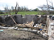
and Parkersburg, Iowa
Parkersburg, Iowa
Parkersburg is a city in Butler County, Iowa, United States. The population was 1,870 in the 2010 census, a decline from 1,889 in the 2000 census. Parkersburg, although not the county seat, has the highest population of all the cities in Butler County....
. The Parkersburg tornado was rated an EF5 on the Enhanced Fujita Scale
Enhanced Fujita Scale
The Enhanced Fujita Scale rates the strength of tornadoes in the United States based on the damage they cause.Implemented in place of the Fujita scale introduced in 1971 by Ted Fujita, it began operational use on February 1, 2007. The scale has the same basic design as the original Fujita scale:...
with winds of 205 mph. Seven people were killed in Iowa
Iowa
Iowa is a state located in the Midwestern United States, an area often referred to as the "American Heartland". It derives its name from the Ioway people, one of the many American Indian tribes that occupied the state at the time of European exploration. Iowa was a part of the French colony of New...
, two in Kansas
Kansas
Kansas is a US state located in the Midwestern United States. It is named after the Kansas River which flows through it, which in turn was named after the Kansa Native American tribe, which inhabited the area. The tribe's name is often said to mean "people of the wind" or "people of the south...
and one in each Minnesota
Minnesota
Minnesota is a U.S. state located in the Midwestern United States. The twelfth largest state of the U.S., it is the twenty-first most populous, with 5.3 million residents. Minnesota was carved out of the eastern half of the Minnesota Territory and admitted to the Union as the thirty-second state...
and Colorado
Colorado
Colorado is a U.S. state that encompasses much of the Rocky Mountains as well as the northeastern portion of the Colorado Plateau and the western edge of the Great Plains...
.
The second outbreak lasted from May 29 to May 31 and produced 96 tornado reports from Wyoming
Wyoming
Wyoming is a state in the mountain region of the Western United States. The western two thirds of the state is covered mostly with the mountain ranges and rangelands in the foothills of the Eastern Rocky Mountains, while the eastern third of the state is high elevation prairie known as the High...
to Virginia
Virginia
The Commonwealth of Virginia , is a U.S. state on the Atlantic Coast of the Southern United States. Virginia is nicknamed the "Old Dominion" and sometimes the "Mother of Presidents" after the eight U.S. presidents born there...
. No fatalities have been reported.
Weaker tornadoes between the two main outbreaks occurred also from May 26 to May 28 in Wyoming, Texas
Texas
Texas is the second largest U.S. state by both area and population, and the largest state by area in the contiguous United States.The name, based on the Caddo word "Tejas" meaning "friends" or "allies", was applied by the Spanish to the Caddo themselves and to the region of their settlement in...
, New Mexico
New Mexico
New Mexico is a state located in the southwest and western regions of the United States. New Mexico is also usually considered one of the Mountain States. With a population density of 16 per square mile, New Mexico is the sixth-most sparsely inhabited U.S...
, Kansas
Kansas
Kansas is a US state located in the Midwestern United States. It is named after the Kansas River which flows through it, which in turn was named after the Kansa Native American tribe, which inhabited the area. The tribe's name is often said to mean "people of the wind" or "people of the south...
, Illinois
Illinois
Illinois is the fifth-most populous state of the United States of America, and is often noted for being a microcosm of the entire country. With Chicago in the northeast, small industrial cities and great agricultural productivity in central and northern Illinois, and natural resources like coal,...
, Indiana
Indiana
Indiana is a US state, admitted to the United States as the 19th on December 11, 1816. It is located in the Midwestern United States and Great Lakes Region. With 6,483,802 residents, the state is ranked 15th in population and 16th in population density. Indiana is ranked 38th in land area and is...
and Ontario
Ontario
Ontario is a province of Canada, located in east-central Canada. It is Canada's most populous province and second largest in total area. It is home to the nation's most populous city, Toronto, and the nation's capital, Ottawa....
.
This is the list of tornadoes from the Late-May 2008 tornado outbreak sequence.
Reported tornadoes
Note: three tornadoes in Canada were rated according to the original Fujita scaleFujita scale
The Fujita scale , or Fujita-Pearson scale, is a scale for rating tornado intensity, based primarily on the damage tornadoes inflict on human-built structures and vegetation...
, but are included in the chart below using their number rated.
May 22 event
| List of reported tornadoes - Thursday, May 22, 2008 | ||||||
|---|---|---|---|---|---|---|
Enhanced Fujita Scale The Enhanced Fujita Scale rates the strength of tornadoes in the United States based on the damage they cause.Implemented in place of the Fujita scale introduced in 1971 by Ted Fujita, it began operational use on February 1, 2007. The scale has the same basic design as the original Fujita scale:... |
|
|
|
|
|
|
| Colorado Colorado Colorado is a U.S. state that encompasses much of the Rocky Mountains as well as the northeastern portion of the Colorado Plateau and the western edge of the Great Plains... |
||||||
| EF3 | Windsor Windsor, Colorado The Town of Windsor is a Home Rule Municipality in Larimer and Weld counties in the U.S. state of Colorado. According to the 2010 Census, the population of the town was 18,644. Windsor is located in the region known as Northern Colorado. Windsor is situated north of the Colorado State Capitol in... area |
Weld Weld County, Colorado As of the census of 2000, there were 180,936 people, 63,247 households, and 45,221 families residing in the county. The population density was 45 people per square mile . There were 66,194 housing units at an average density of 17 per square mile... , Larimer Larimer County, Colorado Larimer County is the seventh most populous and the ninth most extensive of the 64 counties of the State of Colorado of the United States. The county is located at the northern end of the Front Range, at the edge of the Colorado Eastern Plains along the border with Wyoming... |
40.49°N 104.91°W | 1826 | 35 miles (56 km) |
1 death - See section on this tornado |
| Wyoming Wyoming Wyoming is a state in the mountain region of the Western United States. The western two thirds of the state is covered mostly with the mountain ranges and rangelands in the foothills of the Eastern Rocky Mountains, while the eastern third of the state is high elevation prairie known as the High... |
||||||
| EF2 | SW of Buford Buford, Wyoming Buford is an unincorporated community in Albany County, Wyoming, United States. It is located between Laramie and Cheyenne on Interstate 80. Buford is at 8000 feet of elevation, making it the highest community on Interstate 80... to Laramie Laramie, Wyoming Laramie is a city in and the county seat of Albany County, Wyoming, United States. The population was 30,816 at the . Located on the Laramie River in southeastern Wyoming, the city is west of Cheyenne, at the junction of Interstate 80 and U.S. Route 287.... |
Albany | 41.31°N 105.58°W | 1910 | 20 miles (32 km) |
Tornado tracked across the eastern and northern parts of the city. A high school High school High school is a term used in parts of the English speaking world to describe institutions which provide all or part of secondary education. The term is often incorporated into the name of such institutions.... , a junior high school and a Wal-Mart Wal-Mart Wal-Mart Stores, Inc. , branded as Walmart since 2008 and Wal-Mart before then, is an American public multinational corporation that runs chains of large discount department stores and warehouse stores. The company is the world's 18th largest public corporation, according to the Forbes Global 2000... were damaged, along with numerous houses nearby. One person was injured near Buford. |
| EF1 | E of Cheyenne Cheyenne, Wyoming Cheyenne is the capital and most populous city of the U.S. state of Wyoming and the county seat of Laramie County. It is the principal city of the Cheyenne, Wyoming, Metropolitan Statistical Area which encompasses all of Laramie County. The population is 59,466 at the 2010 census. Cheyenne is the... |
Laramie Laramie County, Wyoming Laramie County is the most populous of the 23 counties of the U.S. state of Wyoming. The county is located in the southeastern corner of the state. The county's population was 91,738 at the 2010 census. The county seat is Cheyenne, the state capital... |
41.07°N 105.35°W | 0228 | 1 mile (1.6 km) |
A pole barn was destroyed |
| EF0 | SW of Cheyenne Cheyenne, Wyoming Cheyenne is the capital and most populous city of the U.S. state of Wyoming and the county seat of Laramie County. It is the principal city of the Cheyenne, Wyoming, Metropolitan Statistical Area which encompasses all of Laramie County. The population is 59,466 at the 2010 census. Cheyenne is the... |
Laramie Laramie County, Wyoming Laramie County is the most populous of the 23 counties of the U.S. state of Wyoming. The county is located in the southeastern corner of the state. The county's population was 91,738 at the 2010 census. The county seat is Cheyenne, the state capital... |
41.28°N 105.24°W | 0232 | unknown | Brief touchdown |
| Kansas Kansas Kansas is a US state located in the Midwestern United States. It is named after the Kansas River which flows through it, which in turn was named after the Kansa Native American tribe, which inhabited the area. The tribe's name is often said to mean "people of the wind" or "people of the south... |
||||||
| EF0 | SW of Gove | Gove Gove County, Kansas Gove County is a county located in Northwest Kansas, in the Central United States. As of the 2010 census, the county population was 2,695... |
38.78°N 100.73°W | 2045 | 1 mile (1.6 km) |
No damage reported |
| EF0 | S of Grinnell Grinnell, Kansas Grinnell is a city in Gove County, Kansas, United States. As of the 2010 census, the city population was 259.-Geography:Grinnell is located at . According to the United States Census Bureau, the city has a total area of , all of it land.-Demographics:As of the census of 2000, there were 329... |
Gove Gove County, Kansas Gove County is a county located in Northwest Kansas, in the Central United States. As of the 2010 census, the county population was 2,695... |
38.98°N 100.63°W | 2107 | 3 miles (4.8 km) |
No damage reported |
| EF1 | W of Selden Selden, Kansas Selden is a city in Sheridan County, Kansas, United States. As of the 2010 census, the city population was 219.-Geography:Selden is located at . According to the United States Census Bureau, the city has a total area of , all of it land.-Demographics:As of the census of 2000, there were 201... |
Sheridan Sheridan County, Kansas Sheridan County is a county located in the U.S. state of Kansas. As of the 2010 census, the county population was 2,556. Its county seat is Hoxie. The county was named in honor of Phillip H... , Decatur Decatur County, Kansas Decatur County is a county located in Northwest Kansas, in the Central United States. As of the 2010 census, the county population was 2,961. Its county seat and most populous city is Oberlin. The county is named in honor of Commodore Stephen Decatur, Jr.-History:The county was established... |
39.14°N 100.51°W | 2211 | 17.5 miles (28 km) |
Damage to outbuildings and trees at a farmstead |
| EF0 | W of Granfield | Gove Gove County, Kansas Gove County is a county located in Northwest Kansas, in the Central United States. As of the 2010 census, the county population was 2,695... , Sheridan Sheridan County, Kansas Sheridan County is a county located in the U.S. state of Kansas. As of the 2010 census, the county population was 2,556. Its county seat is Hoxie. The county was named in honor of Phillip H... |
39.14°N 100.51°W | 2214 | 11 miles (17.6 km) |
Minor damage reported to sheds. |
| EF0 | NW of Alamota | Lane Lane County, Kansas Lane County is a county located in the U.S. state of Kansas. As of the 2010 census, the county population was 1,750. The county seat is Dighton, the only city in the county. Lane County was named after James H. Lane who was a leader of the Jayhawker abolitionist movement and served as one of... |
39.46°N 100.37°W | 2232 | 5 miles (8 km) |
Tornado over open area |
| EF1 | SW of Oberlin Oberlin, Kansas Oberlin is a city in and the county seat of Decatur County, Kansas, United States. As of the 2010 census, the city population was 1,788.-History:... |
Decatur Decatur County, Kansas Decatur County is a county located in Northwest Kansas, in the Central United States. As of the 2010 census, the county population was 2,961. Its county seat and most populous city is Oberlin. The county is named in honor of Commodore Stephen Decatur, Jr.-History:The county was established... |
39.79°N 100.57°W | 2248 | 13 miles (20.8 km) |
Damage limited to irrigation pivots with some destroyed |
| EF2 | W of Hoxie Hoxie, Kansas Hoxie is a city in and the county seat of Sheridan County, Kansas, United States. As of the 2010 census, the city population was 1,201.-Geography:Hoxie is located at... |
Sheridan Sheridan County, Kansas Sheridan County is a county located in the U.S. state of Kansas. As of the 2010 census, the county population was 2,556. Its county seat is Hoxie. The county was named in honor of Phillip H... |
39.40°N 100.49°W | 2255 | 9 miles (14.4 km) |
Large wedge tornado reported. One house was heavily damaged and power poles were knocked over. |
| EF1 | SE of Gove | Gove Gove County, Kansas Gove County is a county located in Northwest Kansas, in the Central United States. As of the 2010 census, the county population was 2,695... |
38.79°N 100.17°W | 2308 | 8 miles (12.8 km) |
A house and several outbuildings were damaged. |
| EF0 | SE of Selden Selden, Kansas Selden is a city in Sheridan County, Kansas, United States. As of the 2010 census, the city population was 219.-Geography:Selden is located at . According to the United States Census Bureau, the city has a total area of , all of it land.-Demographics:As of the census of 2000, there were 201... (1st tornado) |
Sheridan Sheridan County, Kansas Sheridan County is a county located in the U.S. state of Kansas. As of the 2010 census, the county population was 2,556. Its county seat is Hoxie. The county was named in honor of Phillip H... |
2318 | 2 miles (3.2 km) |
Tornado over open country | |
| EF0 | SE of Selden Selden, Kansas Selden is a city in Sheridan County, Kansas, United States. As of the 2010 census, the city population was 219.-Geography:Selden is located at . According to the United States Census Bureau, the city has a total area of , all of it land.-Demographics:As of the census of 2000, there were 201... (2nd tornado) |
Sheridan Sheridan County, Kansas Sheridan County is a county located in the U.S. state of Kansas. As of the 2010 census, the county population was 2,556. Its county seat is Hoxie. The county was named in honor of Phillip H... |
2320 | 1 mile (1.6 km) |
Tornado over open country | |
| EF0 | S of Collyer Collyer, Kansas Collyer is a city in Trego County, Kansas, United States. As of the 2010 census, the city population was 109.-Geography:Collyer is located at . According to the United States Census Bureau, the city has a total area of , all of it land.-Demographics:As of the census of 2000, there were 133... |
Trego Trego County, Kansas Trego County is a county located in the U.S. state of Kansas. As of the 2010 census, the county population was 3,001... |
38.99°N 100.12°W | 2326 | 5 miles (8 km) |
No damage reported |
| EF1 | W of Dresden Dresden, Kansas Dresden is a city in Decatur County, Kansas, United States. As of the 2010 census, the city population was 41.-Geography:Dresden is located at . According to the United States Census Bureau, the city has a total area of , all of it land.-Demographics:As of the census of 2000, there were 51... |
Decatur Decatur County, Kansas Decatur County is a county located in Northwest Kansas, in the Central United States. As of the 2010 census, the county population was 2,961. Its county seat and most populous city is Oberlin. The county is named in honor of Commodore Stephen Decatur, Jr.-History:The county was established... (KS), Red Willow Red Willow County, Nebraska -History:Red Willow County was formed in 1873. It was named after the Red Willow Creek.-Demographics:As of the census of 2000, there were 11,448 people, 4,710 households, and 3,188 families residing in the county. The population density was 16 people per square mile . There were 5,278 housing... (NE) |
39.61°N 100.41°W | 2331 | 34 miles (54.4 km) |
Damage reported to a house and a ranch, and some farm equipment. Outbuildings were destroyed and utility poles snapped. |
| EF0 | SE of Quinter Quinter, Kansas Quinter is a city in Gove County, Kansas, United States. As of the 2010 census, the city population was 918.-History:The city of Quinter is built at the location of an old railroad switching site called Melota. A town named Familton was built there in 1885, consisting originally of a two-story... |
Gove Gove County, Kansas Gove County is a county located in Northwest Kansas, in the Central United States. As of the 2010 census, the county population was 2,695... |
2332 | 1 mile (1.6 km) |
Tornado over open country | |
| EF1 | SW of Utica Utica, Kansas Utica is a city in Ness County, Kansas, United States. As of the 2010 census, the city population was 158.-History:Utica was named by early pioneer C.W. Bell who was from Utica, New York.-Geography:Utica is located at... |
Ness Ness County, Kansas Ness County is a county located in the U.S. state of Kansas. As of the 2010 census, the county population was 3,107. The largest city and county seat is Ness City. Ness County was named for Corporal Noah V. Ness of the 7th Kansas Cavalry... |
38.57°N 100.22°W | 0100 | 4 miles (6.4 km) |
A cattle shed and a barn were blown away. Fences were downed |
| EF0 | SE of Pendennis | Lane Lane County, Kansas Lane County is a county located in the U.S. state of Kansas. As of the 2010 census, the county population was 1,750. The county seat is Dighton, the only city in the county. Lane County was named after James H. Lane who was a leader of the Jayhawker abolitionist movement and served as one of... |
38.55°N 100.26°W | 0105 | 1 mile (1.6 km) |
No damage reported |
| EF1 | Wakeeney WaKeeney, Kansas WaKeeney is a city in and the county seat of Trego County, Kansas, United States. As of the 2010 census, the city population was 1,862.-History:... |
Trego Trego County, Kansas Trego County is a county located in the U.S. state of Kansas. As of the 2010 census, the county population was 3,001... |
38.97°N 99.89°W | 0157 | 3 miles (4.8 km) |
Damage reported at the Wakeeney Airport with hangars blown off. A local high school sustained roof damage, and damage was reported at a KOA Kampgrounds of America Kampgrounds of America is a franchise chain of nearly 470 campgrounds throughout North America based in Billings, Montana, USA. The current CEO of Kampgrounds of America Inc. is James D. Rogers. The President is Pat Hittmeier. - History :... campground. Several other businesses were damaged. |
| Nebraska Nebraska Nebraska is a state on the Great Plains of the Midwestern United States. The state's capital is Lincoln and its largest city is Omaha, on the Missouri River.... |
||||||
| EF0 | S of Wauneta Wauneta, Nebraska Wauneta is a village in Chase County, Nebraska, United States. The population was 625 at the 2000 census.-Geography:Wauneta is located at .According to the United States Census Bureau, the village has a total area of , all land.... |
Chase Chase County, Nebraska -Demographics:As of the census of 2000, there were 4,068 people, 1,662 households, and 1,163 families residing in the county. The population density was 4 people per square mile . There were 1,927 housing units at an average density of 2 per square mile... |
2229 | unknown | Tornado over open country | |
| Sources: SPC Storm Reports for May 22, 2008, NWS Goodland, NWS Denver, NWS Dodge City | ||||||
May 23 event
| List of reported tornadoes - Friday, May 23, 2008 | ||||||
|---|---|---|---|---|---|---|
Enhanced Fujita Scale The Enhanced Fujita Scale rates the strength of tornadoes in the United States based on the damage they cause.Implemented in place of the Fujita scale introduced in 1971 by Ted Fujita, it began operational use on February 1, 2007. The scale has the same basic design as the original Fujita scale:... |
|
|
|
|
|
|
| Wyoming Wyoming Wyoming is a state in the mountain region of the Western United States. The western two thirds of the state is covered mostly with the mountain ranges and rangelands in the foothills of the Eastern Rocky Mountains, while the eastern third of the state is high elevation prairie known as the High... |
||||||
| EF1 | NW of Cheyenne Cheyenne, Wyoming Cheyenne is the capital and most populous city of the U.S. state of Wyoming and the county seat of Laramie County. It is the principal city of the Cheyenne, Wyoming, Metropolitan Statistical Area which encompasses all of Laramie County. The population is 59,466 at the 2010 census. Cheyenne is the... |
Laramie Laramie County, Wyoming Laramie County is the most populous of the 23 counties of the U.S. state of Wyoming. The county is located in the southeastern corner of the state. The county's population was 91,738 at the 2010 census. The county seat is Cheyenne, the state capital... |
41.27°N 104.96°W | 2113 | 3 miles (4.8 km) |
Tornado over open country |
| EF0 | NE of Chuggwater Chugwater, Wyoming Chugwater is a town in Platte County, Wyoming, in the United States. As of the 2000 census, the town population was 244.-History:In a 2005 promotion to attract new people to the town, building lots were offered for $100 provided the new owner built a house within a year and lived in it for at least... to NE of Wheatland Wheatland, Wyoming Wheatland is a town in and the county seat of Platte County in southeastern Wyoming, United States. The population was 3,548 at the 2000 census.-Geography:Wheatland is located at .... |
Platte | 42.07°N 104.82°W | 2200 | 20 miles (32 km) |
Tornado over open country |
| EF0 | SW of Pine Bluffs Pine Bluffs, Wyoming -Demographics:As of the census of 2000, there were 1,153 people, 482 households, and 332 families residing in the town. The population density was 357.4 people per square mile . There were 517 housing units at an average density of 160.3 per square mile... |
Laramie Laramie County, Wyoming Laramie County is the most populous of the 23 counties of the U.S. state of Wyoming. The county is located in the southeastern corner of the state. The county's population was 91,738 at the 2010 census. The county seat is Cheyenne, the state capital... |
41.12°N 104.15°W | 2209 | 2 miles (3.2 km) |
Tornado touchdown south of Interstate 80 Interstate 80 Interstate 80 is the second-longest Interstate Highway in the United States, following Interstate 90. It is a transcontinental artery running from downtown San Francisco, California to Teaneck, New Jersey in the New York City Metropolitan Area... at mile 394. |
| EF1 | SW of La Grange La Grange, Wyoming La Grange is a town in Goshen County, Wyoming, United States. The population was 332 at the 2000 census.-Geography:La Grange is located at .... to SW of Yoder Yoder, Wyoming Yoder is a town in Goshen County, Wyoming, United States. The population was 169 at the 2000 census.-Geography:Yoder is located at .... |
Goshen | 41.52°N 104.16°W | 2326 | 24 miles (38.4 km) |
One mobile home lost its roof |
| Kansas Kansas Kansas is a US state located in the Midwestern United States. It is named after the Kansas River which flows through it, which in turn was named after the Kansa Native American tribe, which inhabited the area. The tribe's name is often said to mean "people of the wind" or "people of the south... |
||||||
| EF0 | SE of Gove (1st tornado) | Gove Gove County, Kansas Gove County is a county located in Northwest Kansas, in the Central United States. As of the 2010 census, the county population was 2,695... |
2102 | 1 mile (1.6 km) |
Brief tornado with no damage | |
| EF0 | SE of Quinter Quinter, Kansas Quinter is a city in Gove County, Kansas, United States. As of the 2010 census, the city population was 918.-History:The city of Quinter is built at the location of an old railroad switching site called Melota. A town named Familton was built there in 1885, consisting originally of a two-story... |
Gove Gove County, Kansas Gove County is a county located in Northwest Kansas, in the Central United States. As of the 2010 census, the county population was 2,695... |
2120 | 5 miles (8 km) |
Large tornado with no damage | |
| EF0 | SE of Friend Friend, Kansas Friend is an unincorporated community in Finney County, Kansas, United States. The town is located next to U.S. Route 83 and the North Line of the Garden City Western Railway, south to the county line of Scott County. Other nearby communities include Shallow Water to the north and Tennis to the... |
Finney Finney County, Kansas Finney County is a county located in Southwest Kansas, in the Central United States. As of the 2010 census, the county population was 36,776. Its county seat and most populous city is Garden City... |
2129 | 2 miles (3.2 km) |
Minor tree damage | |
| EF1 | W of Quinter Quinter, Kansas Quinter is a city in Gove County, Kansas, United States. As of the 2010 census, the city population was 918.-History:The city of Quinter is built at the location of an old railroad switching site called Melota. A town named Familton was built there in 1885, consisting originally of a two-story... (1st tornado) |
Gove Gove County, Kansas Gove County is a county located in Northwest Kansas, in the Central United States. As of the 2010 census, the county population was 2,695... , Sheridan Sheridan County, Kansas Sheridan County is a county located in the U.S. state of Kansas. As of the 2010 census, the county population was 2,556. Its county seat is Hoxie. The county was named in honor of Phillip H... |
39.07°N 100.26°W | 2134 | 5 miles (8 km) |
Damage to utility poles and trees |
| EF2 | W of Quinter Quinter, Kansas Quinter is a city in Gove County, Kansas, United States. As of the 2010 census, the city population was 918.-History:The city of Quinter is built at the location of an old railroad switching site called Melota. A town named Familton was built there in 1885, consisting originally of a two-story... (2nd tornado) |
Gove Gove County, Kansas Gove County is a county located in Northwest Kansas, in the Central United States. As of the 2010 census, the county population was 2,695... , Sheridan Sheridan County, Kansas Sheridan County is a county located in the U.S. state of Kansas. As of the 2010 census, the county population was 2,556. Its county seat is Hoxie. The county was named in honor of Phillip H... |
39.07°N 100.26°W | 2135 | 14 miles (22.4 km) |
Wedge tornado videotaped at the same time a second tornado was nearby. Extensive utility pole damage and damage to homesteads and outbuildings. A mobile home was blown off its supports into a home which was destroyed on impact. |
| EF1 | W of Dighton Dighton, Kansas Dighton is a city in and the county seat of Lane County, Kansas, United States. As of the 2010 census, the city population was 1,038.-19th century:... |
Lane Lane County, Kansas Lane County is a county located in the U.S. state of Kansas. As of the 2010 census, the county population was 1,750. The county seat is Dighton, the only city in the county. Lane County was named after James H. Lane who was a leader of the Jayhawker abolitionist movement and served as one of... |
38.48°N 100.48°W | 2201 | 8 miles (12.8 km) |
Damage to pivot irrigation sprinklers and power poles |
| EF1 | S of Studley | Graham Graham County, Kansas Graham County is a county located in northwest Kansas, in the Central United States. As of the 2010 census, the county population was 2,597. Its county seat and most populous city is Hill City... |
39.23°N 100.16°W | 2210 | 14 miles (22.4 km) |
Long lived wedge tornado confirmed. 1/2 mile of power poles were downed |
| EF0 | N of Dighton Dighton, Kansas Dighton is a city in and the county seat of Lane County, Kansas, United States. As of the 2010 census, the city population was 1,038.-19th century:... |
Lane Lane County, Kansas Lane County is a county located in the U.S. state of Kansas. As of the 2010 census, the county population was 1,750. The county seat is Dighton, the only city in the county. Lane County was named after James H. Lane who was a leader of the Jayhawker abolitionist movement and served as one of... |
2215 | 3 miles (4.8 km) |
Minor tree damage | |
| EF0 | NW of Dighton Dighton, Kansas Dighton is a city in and the county seat of Lane County, Kansas, United States. As of the 2010 census, the city population was 1,038.-19th century:... |
Lane Lane County, Kansas Lane County is a county located in the U.S. state of Kansas. As of the 2010 census, the county population was 1,750. The county seat is Dighton, the only city in the county. Lane County was named after James H. Lane who was a leader of the Jayhawker abolitionist movement and served as one of... |
38.49°N 100.47°W | 2215 | 1 mile (1.6 km) |
Satellite tornado with damage to a pivot sprinkler |
| EF0 | E of Healy Healy, Kansas Healy is an unincorporated rural area in Lane County, Kansas, United States. It lies in Cheyenne Township on K-4 16 miles east of the highway's western end at U.S. Route 83.-External links:* * , local school district*... |
Lane Lane County, Kansas Lane County is a county located in the U.S. state of Kansas. As of the 2010 census, the county population was 1,750. The county seat is Dighton, the only city in the county. Lane County was named after James H. Lane who was a leader of the Jayhawker abolitionist movement and served as one of... |
2222 | 2 miles (3.2 km) |
No damage reported | |
| EF0 | SE of Ingalls Ingalls, Kansas Ingalls is a city in Gray County, Kansas, United States. As of the 2010 census, the city population was 306.-Geography:Ingalls is located at . According to the United States Census Bureau, the city has a total area of , all of it land.-Demographics:As of the census of 2000, there were 328 people,... |
Gray Gray County, Kansas Gray County is a county located in Southwest Kansas, in the Central United States. As of the 2010 census, the county population was 6,006... |
37.79°N 100.40°W | 2224 | 1 mile (1.6 km) |
Brief spin-up tornado lasting less than a minute |
| EF1 | NW of Shields | Lane Lane County, Kansas Lane County is a county located in the U.S. state of Kansas. As of the 2010 census, the county population was 1,750. The county seat is Dighton, the only city in the county. Lane County was named after James H. Lane who was a leader of the Jayhawker abolitionist movement and served as one of... |
2235 | 4 miles (6.4 km) |
Damage to trees | |
| EF0 | SE of Gove (2nd tornado) | Gove Gove County, Kansas Gove County is a county located in Northwest Kansas, in the Central United States. As of the 2010 census, the county population was 2,695... |
2235 | 5 miles (8 km) |
Tornado over open country | |
| EF2 | W of Quinter Quinter, Kansas Quinter is a city in Gove County, Kansas, United States. As of the 2010 census, the city population was 918.-History:The city of Quinter is built at the location of an old railroad switching site called Melota. A town named Familton was built there in 1885, consisting originally of a two-story... to SE of Tasco |
Gove Gove County, Kansas Gove County is a county located in Northwest Kansas, in the Central United States. As of the 2010 census, the county population was 2,695... , Lane Lane County, Kansas Lane County is a county located in the U.S. state of Kansas. As of the 2010 census, the county population was 1,750. The county seat is Dighton, the only city in the county. Lane County was named after James H. Lane who was a leader of the Jayhawker abolitionist movement and served as one of... |
38.73°N 100.43°W | 2240 | 16 miles (25.6 km) |
Tornado reported on the county line. One home was destroyed with others damaged. |
| EF0 | NE of Shields | Lane Lane County, Kansas Lane County is a county located in the U.S. state of Kansas. As of the 2010 census, the county population was 1,750. The county seat is Dighton, the only city in the county. Lane County was named after James H. Lane who was a leader of the Jayhawker abolitionist movement and served as one of... |
2245 | 1 mile (1.6 km) |
No damage observed | |
| EF4 | Quinter Quinter, Kansas Quinter is a city in Gove County, Kansas, United States. As of the 2010 census, the city population was 918.-History:The city of Quinter is built at the location of an old railroad switching site called Melota. A town named Familton was built there in 1885, consisting originally of a two-story... area |
Gove Gove County, Kansas Gove County is a county located in Northwest Kansas, in the Central United States. As of the 2010 census, the county population was 2,695... |
39.05°N 100.15°W | 2310 | 11 miles (17.6 km) |
Large wedge tornado confirmed via KSNK KSNK KSNK digital channel 12 is an NBC affiliate licensed to McCook, Nebraska with its studio and transmitter located just west of Oberlin, Kansas. It is owned by New Vision Television, Inc.... broadcast. Three homes were completely destroyed and several others were damaged. Two vehicles were moved 200 yards, and one person was injured when the tornado crossed Interstate 70 Interstate 70 Interstate 70 is an Interstate Highway in the United States that runs from Interstate 15 near Cove Fort, Utah, to a Park and Ride near Baltimore, Maryland. It was the first Interstate Highway project in the United States. I-70 approximately traces the path of U.S. Route 40 east of the Rocky... . |
| EF0 | N of Kalvesta Kalvesta, Kansas Kalvesta is an unincorporated community in Finney County, Kansas, United States. Kalvesta is located on K-156 north-northeast of Cimarron.... |
Finney Finney County, Kansas Finney County is a county located in Southwest Kansas, in the Central United States. As of the 2010 census, the county population was 36,776. Its county seat and most populous city is Garden City... , Hodgeman Hodgeman County, Kansas Hodgeman County is a county located in Southwest Kansas, in the Central United States. As of the 2010 census, the county population was 1,916... , Ness Ness County, Kansas Ness County is a county located in the U.S. state of Kansas. As of the 2010 census, the county population was 3,107. The largest city and county seat is Ness City. Ness County was named for Corporal Noah V. Ness of the 7th Kansas Cavalry... , Lane Lane County, Kansas Lane County is a county located in the U.S. state of Kansas. As of the 2010 census, the county population was 1,750. The county seat is Dighton, the only city in the county. Lane County was named after James H. Lane who was a leader of the Jayhawker abolitionist movement and served as one of... |
2325 | 6 miles (9.6 km) |
No known damage | |
| EF0 | NW of Englewood Englewood, Kansas Englewood is a city in Clark County, Kansas, United States. As of the 2010 census, the city population was 77.-Geography:Englewood is located at . According to the United States Census Bureau, the city has a total area of , all of it land.-Demographics:As of the census of 2000, there were 109... |
Clark Clark County, Kansas Clark County is a county located in Southwest Kansas, in the Central United States. As of the 2010 census, the county population was 2,215... |
2337 | 2 miles (3.2 km) |
Minor tree damage | |
| EF0 | SE of Beeler Beeler, Kansas Beeler is an unincorporated community in western Ness County, Kansas, United States. It lies along K-96 west of the city of Ness City, the county seat of Ness County. Its elevation is 2,490 feet , and it is located at . Although it is unincorporated, it has a post office, with the ZIP... |
Ness Ness County, Kansas Ness County is a county located in the U.S. state of Kansas. As of the 2010 census, the county population was 3,107. The largest city and county seat is Ness City. Ness County was named for Corporal Noah V. Ness of the 7th Kansas Cavalry... |
2352 | 2 miles (3.2 km) |
Tornado over open country | |
| EF0 | SW of Studley | Sheridan Sheridan County, Kansas Sheridan County is a county located in the U.S. state of Kansas. As of the 2010 census, the county population was 2,556. Its county seat is Hoxie. The county was named in honor of Phillip H... |
2352 | 4 miles (6.4 km) |
Large wedge tornado but no damage | |
| EF0 | SW of Laird | Ness Ness County, Kansas Ness County is a county located in the U.S. state of Kansas. As of the 2010 census, the county population was 3,107. The largest city and county seat is Ness City. Ness County was named for Corporal Noah V. Ness of the 7th Kansas Cavalry... |
2358 | 4 miles (6.4 km) |
Tornado over inhabited land | |
| EF0 | NW of Ashland Ashland, Kansas Ashland is the largest city in and the county seat of Clark County, Kansas, United States. As of the 2010 census, the city population was 867.-History:... |
Clark Clark County, Kansas Clark County is a county located in Southwest Kansas, in the Central United States. As of the 2010 census, the county population was 2,215... |
0001 | 3 miles (4.8 km) |
Tornado touchdown, no known damage | |
| EF0 | NW of Leoti Leoti, Kansas Leoti, pronounced "Lee-oh-TAH", is a city in and the county seat of Wichita County, Kansas, United States. As of the 2010 census, the city population was 1,534.- History :... |
Wichita Wichita County, Kansas Wichita County is a county located in the U.S. state of Kansas. As of the 2010 census, the county population was 2,234... |
38.50°N 101.41°W | 0005 | 1 mile (1.6 km) |
Brief tornado with no damage |
| EF2 | N of Laird | Ness Ness County, Kansas Ness County is a county located in the U.S. state of Kansas. As of the 2010 census, the county population was 3,107. The largest city and county seat is Ness City. Ness County was named for Corporal Noah V. Ness of the 7th Kansas Cavalry... |
0007 | 12 mile (19.2 km) |
Damage to trees, power poles, a large tank, a barn and hay bales | |
| EF0 | S of Tasco | Sheridan Sheridan County, Kansas Sheridan County is a county located in the U.S. state of Kansas. As of the 2010 census, the county population was 2,556. Its county seat is Hoxie. The county was named in honor of Phillip H... |
39.17°N 100.23°W | 0015 | 6 miles (9.6 km) |
Tornado over open country with no damage |
| EF3 | Clark State Lake to SW of Mullinville Mullinville, Kansas Mullinville is a city in Kiowa County, Kansas, United States. As of the 2010 census, the city population was 255.-Geography:Mullinville is located at... |
Clark Clark County, Kansas Clark County is a county located in Southwest Kansas, in the Central United States. As of the 2010 census, the county population was 2,215... , Kiowa Kiowa County, Kansas Kiowa County is a county located in the U.S. state of Kansas. As of the 2010 census, the county population was 2,553... |
0025 | 21 mile (33.6 km) |
1.8 mile-wide tornado damage two homes, barns and carried an oil tank battery for 1.8 miles. 20 head of cattle were killed and one minor injury. In Kiowa County, trees and power lines were downed while a concrete house was damaged | |
| EF2 | SE of Arnold Arnold, Kansas Arnold is an unincorporated community in northern Ness County, Kansas, United States. It lies along K-4 north-northwest of the city of Ness City, the county seat of Ness County. Its elevation is 2,566 feet , and it is located at . Although it is unincorporated, it has a post office, with... |
Ness Ness County, Kansas Ness County is a county located in the U.S. state of Kansas. As of the 2010 census, the county population was 3,107. The largest city and county seat is Ness City. Ness County was named for Corporal Noah V. Ness of the 7th Kansas Cavalry... |
0025 | 1 mile (1.6 km) |
Satellite tornado with uprooted trees | |
| EF3 | S of Osgood | Ness Ness County, Kansas Ness County is a county located in the U.S. state of Kansas. As of the 2010 census, the county population was 3,107. The largest city and county seat is Ness City. Ness County was named for Corporal Noah V. Ness of the 7th Kansas Cavalry... , Trego Trego County, Kansas Trego County is a county located in the U.S. state of Kansas. As of the 2010 census, the county population was 3,001... |
0029 | 9 miles (14.4 km) |
Damage to two homes, power poles, trees and a farm implement which was carried 1/2 mile. | |
| EF1 | N of Clark State Lake | Clark Clark County, Kansas Clark County is a county located in Southwest Kansas, in the Central United States. As of the 2010 census, the county population was 2,215... |
37.51°N 99.78°W | 0042 | 7 miles (11.2 km) |
Damage to trees, outbuildings and pivot sprinklers |
| EF1 | NE of Clark State Lake | Clark Clark County, Kansas Clark County is a county located in Southwest Kansas, in the Central United States. As of the 2010 census, the county population was 2,215... |
0043 | 1 miles (1.6 km) |
Satellite tornado with damage to trees | |
| EF1 | NW of Brownell Brownell, Kansas Brownell is a city in Ness County, Kansas, United States. As of the 2010 census, the city population was 29.-Geography:Brownell is located at . According to the United States Census Bureau, the city has a total area of , all of it land.-Demographics:As of the census of 2000, there were 48... |
Trego Trego County, Kansas Trego County is a county located in the U.S. state of Kansas. As of the 2010 census, the county population was 3,001... |
38.70°N 99.82°W | 0049 | 8 miles (12.8 km) |
A horse trailer was carried 50 feet and damage to power poles and trees |
| EF2 | SE of Cedar Bluff Resort | Trego Trego County, Kansas Trego County is a county located in the U.S. state of Kansas. As of the 2010 census, the county population was 3,001... |
0058 | 9 miles (14.4 km) |
Mile-wide tornado damaging a house, trees and power poles with an outbuilding being destroyed. Oil tanks were ruptured and several head of cattle were killed | |
| EF0 | SE of Joy | Kiowa Kiowa County, Kansas Kiowa County is a county located in the U.S. state of Kansas. As of the 2010 census, the county population was 2,553... |
0111 | 1 mile (1.6 km) |
Minor tree damage | |
| EF2 | SW of Riga | Trego Trego County, Kansas Trego County is a county located in the U.S. state of Kansas. As of the 2010 census, the county population was 3,001... |
0117 | 8 miles (12.8 km) |
Damage to trees | |
| EF0 | SW of Lake Arrowhead | Barber Barber County, Kansas Barber County is a county located in South Central Kansas, in the Central United States. As of the 2010 census, the county population was 4,861. Its county seat and most populous city is Medicine Lodge... |
0117 | 1 mile (1.6 km) |
Minor tree damage | |
| EF1 | Ellis Ellis, Kansas Ellis is a city in Ellis County, Kansas, United States. As of the 2010 census, the city population was 2,062.- History :The Kansas Pacific Railway built a water station at the site of present-day Ellis in 1867 and then purchased the site under the Homestead Act. Three years later, in 1870, the U.S.... area (1st tornado) |
Ellis Ellis County, Kansas Ellis County is a county located in Northwest Kansas, in the Central United States. As of the 2010 census, the county population was 28,452. Its county seat and most populous city is Hays... |
38.94°N 99.56°W | 0128 | 2 miles (3.2 km) |
Large and dangerous tornado reported in the town with damage reported. Rescue crews headed to outlying areas. Damage to outbuildings, storage tanks, power poles and houses. One injury was reported. |
| EF0 | NE of Greensburg Greensburg, Kansas Greensburg is a city in and the county seat of Kiowa County, Kansas, United States. As of the 2010 census, the city population was 777. Greensburg is also home to the world's largest hand-dug well.... |
Kiowa Kiowa County, Kansas Kiowa County is a county located in the U.S. state of Kansas. As of the 2010 census, the county population was 2,553... |
37.61°N 99.31°W | 0134 | 1 mile (1.6 km) |
Separate tornado west of Greensburg with minor damage reported. |
| EF0 | S of Greensburg Greensburg, Kansas Greensburg is a city in and the county seat of Kiowa County, Kansas, United States. As of the 2010 census, the city population was 777. Greensburg is also home to the world's largest hand-dug well.... |
Kiowa Kiowa County, Kansas Kiowa County is a county located in the U.S. state of Kansas. As of the 2010 census, the county population was 2,553... |
0135 | 2 miles (3.2 km) |
Tornado moved over farmland with no damage | |
| EF0 | N of Ellis Ellis, Kansas Ellis is a city in Ellis County, Kansas, United States. As of the 2010 census, the city population was 2,062.- History :The Kansas Pacific Railway built a water station at the site of present-day Ellis in 1867 and then purchased the site under the Homestead Act. Three years later, in 1870, the U.S.... (1st tornado) |
Ellis Ellis County, Kansas Ellis County is a county located in Northwest Kansas, in the Central United States. As of the 2010 census, the county population was 28,452. Its county seat and most populous city is Hays... |
0140 | 6 miles (9.6 km) |
No damage reported | |
| EF1 | S of Riga | Trego Trego County, Kansas Trego County is a county located in the U.S. state of Kansas. As of the 2010 census, the county population was 3,001... , Ellis Ellis County, Kansas Ellis County is a county located in Northwest Kansas, in the Central United States. As of the 2010 census, the county population was 28,452. Its county seat and most populous city is Hays... |
0144 | 6 miles (9.6 km) |
Power lines and trees downed. Outbuildings and homes were damaged | |
| EF0 | NE of Brenham | Kiowa Kiowa County, Kansas Kiowa County is a county located in the U.S. state of Kansas. As of the 2010 census, the county population was 2,553... |
37.61°N 99.31°W | 0156 | 1 mile (1.6 km) |
No damage reported |
| EF1 | Ellis Ellis, Kansas Ellis is a city in Ellis County, Kansas, United States. As of the 2010 census, the city population was 2,062.- History :The Kansas Pacific Railway built a water station at the site of present-day Ellis in 1867 and then purchased the site under the Homestead Act. Three years later, in 1870, the U.S.... area (2nd tornado) |
Trego Trego County, Kansas Trego County is a county located in the U.S. state of Kansas. As of the 2010 census, the county population was 3,001... , Ellis Ellis County, Kansas Ellis County is a county located in Northwest Kansas, in the Central United States. As of the 2010 census, the county population was 28,452. Its county seat and most populous city is Hays... |
0207 | 6 miles (9.6 km) |
Damage to trees, outbuildings, a grain silo and an oil tank | |
| EF0 | N of Wellsford Wellsford, Kansas Wellsford is an unincorporated community in Kiowa County, Kansas, United States.-Geography:Wellsford is located at .-External links:... |
Kiowa Kiowa County, Kansas Kiowa County is a county located in the U.S. state of Kansas. As of the 2010 census, the county population was 2,553... , Edwards Edwards County, Kansas Edwards County is a county located in Southwest Kansas, in the Central United States. As of the 2010 census, the county population was 3,037... |
0208 | 2 miles (3.2 km) |
Tornado moved into grassland, | |
| EF1 | NW of Turkville | Ellis Ellis County, Kansas Ellis County is a county located in Northwest Kansas, in the Central United States. As of the 2010 census, the county population was 28,452. Its county seat and most populous city is Hays... , Rooks Rooks County, Kansas Rooks County is a county located in the U.S. state of Kansas. As of the 2010 census, the county population was 5,181. The county seat is Stockton and the largest city is Plainville. The county was named for Private John C... |
0208 | 4 miles (6.4 km) |
Damage to trees, outbuilding and power lines | |
| EF0 | SE of Trousdale Trousdale, Kansas Trousdale is an unincorporated community in Lincoln Township, Edwards County, Kansas, United States.-History:It began when a railroad junction was constructed in 1915. It is named for a Newton, Kansas resident who owned land in the vicinity... |
Edwards Edwards County, Kansas Edwards County is a county located in Southwest Kansas, in the Central United States. As of the 2010 census, the county population was 3,037... , Pratt Pratt County, Kansas Pratt County is a county located in the U.S. state of Kansas. As of the 2010 census, the county population was 9,656. The largest city and county seat is Pratt.-19th century:... |
37.54°N 98.61°W | 0211 | 5 miles (8 km) |
Moved over farmland |
| EF0 | N of Ellis Ellis, Kansas Ellis is a city in Ellis County, Kansas, United States. As of the 2010 census, the city population was 2,062.- History :The Kansas Pacific Railway built a water station at the site of present-day Ellis in 1867 and then purchased the site under the Homestead Act. Three years later, in 1870, the U.S.... (2nd tornado) |
Ellis Ellis County, Kansas Ellis County is a county located in Northwest Kansas, in the Central United States. As of the 2010 census, the county population was 28,452. Its county seat and most populous city is Hays... |
38.95°N 99.56°W | 0216 | 1 mile (1.6 km) |
Second large but brief tornado reported in the area. |
| EF3 | S of Trousdale Trousdale, Kansas Trousdale is an unincorporated community in Lincoln Township, Edwards County, Kansas, United States.-History:It began when a railroad junction was constructed in 1915. It is named for a Newton, Kansas resident who owned land in the vicinity... |
Edwards Edwards County, Kansas Edwards County is a county located in Southwest Kansas, in the Central United States. As of the 2010 census, the county population was 3,037... , Pratt Pratt County, Kansas Pratt County is a county located in the U.S. state of Kansas. As of the 2010 census, the county population was 9,656. The largest city and county seat is Pratt.-19th century:... , Stafford Stafford County, Kansas Stafford County is a county located in the U.S. state of Kansas. As of the 2010 census, the county population was 4,437. Its county seat is St. John... |
37.74°N 99.08°W | 0216 | 9 miles (14.4 km) |
Damage reported according to NWS reports by a large wedge tornado. Damage to homes, pivot sprinkler and trees. One person was injured. |
| EF0 | E of Aetna Aetna, Kansas Aetna is an unincorporated community in Barber County, Kansas. It lies at an elevation of 1631 feet .... |
Barber Barber County, Kansas Barber County is a county located in South Central Kansas, in the Central United States. As of the 2010 census, the county population was 4,861. Its county seat and most populous city is Medicine Lodge... |
0222 | 5 miles (8 km) |
Moved over open country | |
| EF0 | E of Sitka Sitka, Kansas Sitka is an unincorporated community in Clark County, Kansas, United States.Its post office was closed on May 22, 1964.The Atchison, Topeka and Santa Fe depot, built in 1930, has been moved to Dodge City and is now part of the Boot Hill Museum.... (1st tornado) |
Clark Clark County, Kansas Clark County is a county located in Southwest Kansas, in the Central United States. As of the 2010 census, the county population was 2,215... , Comanche Comanche County, Kansas Comanche County is a county located in Southwest Kansas, in the Central United States. As of the 2010 census, the county population was 1,891... |
37.03°N 99.60°W | 0226 | 4 miles (6.4 km) |
Minor tree damage |
| EF1 | NW of Bloom Bloom, Kansas Bloom is a small unincorporated community in Ford County, Kansas, United States. The post office closed in 1992.-History:Bloom was established in 1888. The small town sprang to life as the Rock Island Railroad pushed west. The original train depot is still located in Bloom. Bloom reached a... |
Ford Ford County, Kansas Ford County is a county located in southwest Kansas, in the Central United States. As of the 2010 census, the county population was 33,848. The Dodge City Micropolitan Statistical Area includes all of Ford County. Its county seat and most populous city is Dodge City. The county is named in... |
0226 | 6 miles (9.6 km) |
Damage to pivot irrigation sprinklers and a grain bin. | |
| EF1 | Protection Protection, Kansas Protection is a city in Comanche County, Kansas, United States. As of the 2010 census, the city population was 514.-History:The town became nationally and internationally known via radio and television in 1955-1956, when the National Polio Foundation chose it as the center for the free... area |
Comanche Comanche County, Kansas Comanche County is a county located in Southwest Kansas, in the Central United States. As of the 2010 census, the county population was 1,891... |
0230 | 6 miles (9.6 km) |
Community took a direct hit from a large and dangerous tornado according to KSNG KSNG KSNG channel 11 is an NBC affiliate based in Garden City, Kansas. It is owned by New Vision Television, Inc.KSNG is part of the Kansas State Network network of NBC affiliates, repeating the signal of KSNW in Wichita, Kansas, with local advertising and news inserts.-History:It signed on the air on... . Significant damage reported although mostly to trees and power lines. A manufacturing plant had extensive damage |
|
| EF0 | E of Deerhead Deerhead, Kansas Deerhead is an unincorporated community in Barber County, Kansas, United States. Deerhead is west-southwest of Medicine Lodge.... |
Barber Barber County, Kansas Barber County is a county located in South Central Kansas, in the Central United States. As of the 2010 census, the county population was 4,861. Its county seat and most populous city is Medicine Lodge... |
0241 | 4 miles (6.4 km) |
Minor tree damage | |
| EF0 | SW of Sillwyn | Stafford Stafford County, Kansas Stafford County is a county located in the U.S. state of Kansas. As of the 2010 census, the county population was 4,437. Its county seat is St. John... |
0244 | 5 miles (8 km) |
Passed over pasture grass and crops but with no damage | |
| EF1 | SE of Plainville Plainville, Kansas Plainville is a city in Rooks County, Kansas, United States. As of the 2010 census, the city population was 1,903.-19th century:The area was first settled in 1877 by Hiram Keas. Plainville, previously known as Paradise Flats, was established in 1888, in Rooks County, Kansas... |
Rooks Rooks County, Kansas Rooks County is a county located in the U.S. state of Kansas. As of the 2010 census, the county population was 5,181. The county seat is Stockton and the largest city is Plainville. The county was named for Private John C... |
39.20°N 99.26°W | 0245 | 6 miles (9.6 km) |
Power flashes observed and power poles were blown down. |
| EF0 | NE of Protection Protection, Kansas Protection is a city in Comanche County, Kansas, United States. As of the 2010 census, the city population was 514.-History:The town became nationally and internationally known via radio and television in 1955-1956, when the National Polio Foundation chose it as the center for the free... |
Comanche Comanche County, Kansas Comanche County is a county located in Southwest Kansas, in the Central United States. As of the 2010 census, the county population was 1,891... |
0245 | 4 miles (6.4 km) |
Minor tree damage | |
| EF2 | NW of Coldwater Coldwater, Kansas Coldwater is a city in and the county seat of Comanche County, Kansas, United States. As of the 2010 census, the city population was 828.-Geography:Coldwater is located at... |
Comanche Comanche County, Kansas Comanche County is a county located in Southwest Kansas, in the Central United States. As of the 2010 census, the county population was 1,891... , Kiowa Kiowa County, Kansas Kiowa County is a county located in the U.S. state of Kansas. As of the 2010 census, the county population was 2,553... |
0252 | 14 miles (22.4 km) |
Damage to trees, power poles, pivot sprinklers and a house | |
| EF0 | N of Hudson Hudson, Kansas Hudson is a city in Stafford County, Kansas, United States. As of the 2010 census, the city population was 129.-Geography:Hudson is located at . According to the United States Census Bureau, the city has a total area of , all of it land.-Demographics:As of the census of 2000, there were 133... |
Stafford Stafford County, Kansas Stafford County is a county located in the U.S. state of Kansas. As of the 2010 census, the county population was 4,437. Its county seat is St. John... |
38.16°N 98.66°W | 0303 | 9 miles (14.4 km) |
Power lines were reported down on the roads. |
| EF2 | NE of Lake City Lake City, Kansas Lake City is an unincorporated community in Barber County, Kansas, United States. Lake City is northwest of Medicine Lodge. Lake City has a post office with ZIP code 67071.... |
Barber Barber County, Kansas Barber County is a county located in South Central Kansas, in the Central United States. As of the 2010 census, the county population was 4,861. Its county seat and most populous city is Medicine Lodge... |
0308 | 7 miles (11.2 km) |
Damage limited to trees | |
| EF0 | SW of Greensburg Greensburg, Kansas Greensburg is a city in and the county seat of Kiowa County, Kansas, United States. As of the 2010 census, the city population was 777. Greensburg is also home to the world's largest hand-dug well.... |
Kiowa Kiowa County, Kansas Kiowa County is a county located in the U.S. state of Kansas. As of the 2010 census, the county population was 2,553... |
0311 | 4 miles (6.4 km) |
Damage limited to trees and tin was wrapped around a fence. | |
| EF1 | E of Sitka Sitka, Kansas Sitka is an unincorporated community in Clark County, Kansas, United States.Its post office was closed on May 22, 1964.The Atchison, Topeka and Santa Fe depot, built in 1930, has been moved to Dodge City and is now part of the Boot Hill Museum.... (2nd tornado) |
Clark Clark County, Kansas Clark County is a county located in Southwest Kansas, in the Central United States. As of the 2010 census, the county population was 2,215... |
0312 | 10 miles (16 km) |
Damage to trees and power poles | |
| EF2 | E of Windthorst Windthorst, Kansas Windthorst is an unincorporated community in Ford County, Kansas, United States.The present-day community consists of a church, a school, a priest's house, and residential housing, but little more. It has no railroad station or post office. The closest town is Spearville. The community is best... |
Ford Ford County, Kansas Ford County is a county located in southwest Kansas, in the Central United States. As of the 2010 census, the county population was 33,848. The Dodge City Micropolitan Statistical Area includes all of Ford County. Its county seat and most populous city is Dodge City. The county is named in... , Edwards Edwards County, Kansas Edwards County is a county located in Southwest Kansas, in the Central United States. As of the 2010 census, the county population was 3,037... |
0312 | 17 miles (27.2 km) |
Damage to trees and pivot irrigation systems, power poles, outbuildings and a home | |
| EF1 | E of Elm Mills Elm Mills, Kansas Elm Mills is an unincorporated community in Barber County, Kansas, United States. Elm Mills is south of Sawyer.... |
Barber Barber County, Kansas Barber County is a county located in South Central Kansas, in the Central United States. As of the 2010 census, the county population was 4,861. Its county seat and most populous city is Medicine Lodge... , Pratt Pratt County, Kansas Pratt County is a county located in the U.S. state of Kansas. As of the 2010 census, the county population was 9,656. The largest city and county seat is Pratt.-19th century:... |
0315 | 13 miles (20.8 km) |
Damage limited to trees | |
| EF0 | NE of Elm Mills Elm Mills, Kansas Elm Mills is an unincorporated community in Barber County, Kansas, United States. Elm Mills is south of Sawyer.... |
Barber Barber County, Kansas Barber County is a county located in South Central Kansas, in the Central United States. As of the 2010 census, the county population was 4,861. Its county seat and most populous city is Medicine Lodge... , Pratt Pratt County, Kansas Pratt County is a county located in the U.S. state of Kansas. As of the 2010 census, the county population was 9,656. The largest city and county seat is Pratt.-19th century:... |
0317 | 3 miles (4.8 km) |
Minor damage to trees | |
| EF3 | E of Cairo | Pratt Pratt County, Kansas Pratt County is a county located in the U.S. state of Kansas. As of the 2010 census, the county population was 9,656. The largest city and county seat is Pratt.-19th century:... |
37.64°N 98.50°W | 0324 | 24 miles (38.6 km) | 2 deaths - Many power flashes sighted. Fatalities occurred in a vehicle. Six other people were injured and officials stated that 12 homes suffered major damage including one destroyed. |
| EF1 | SE of Great Bend Great Bend, Kansas Great Bend, named for its location at the historic big bend of the Arkansas River, is the most populous city in and the county seat of Barton County, Kansas, United States. As of the 2010 census, the city population was 15,995.-History:... |
Barton Barton County, Kansas Barton County is a county located in Western Kansas, in the Central United States. As of the 2010 census, the county population was 27,674. Its county seat and most populous city is Great Bend. The county is named in honor of Clara Barton, responsible for the founding of the American Red Cross... |
38.28°N 98.70°W | 0330 | unknown | A house was lifted off its foundation and a barn and a garage were destroyed. |
| EF0 | S of Ellinwood Ellinwood, Kansas Ellinwood is a city in the southeast corner of Barton County, Kansas, United States. As of the 2010 census, the city population was 2,131.-History:... |
Barton Barton County, Kansas Barton County is a county located in Western Kansas, in the Central United States. As of the 2010 census, the county population was 27,674. Its county seat and most populous city is Great Bend. The county is named in honor of Clara Barton, responsible for the founding of the American Red Cross... |
38.28°N 98.65°W | 0338 | unknown | Large tornado confirmed but remained in open country with damage to a few trees and power lines. |
| EF2 | Kinsley Kinsley, Kansas Kinsley is a city in and the county seat of Edwards County, Kansas, United States. As of the 2010 census, the city population was 1,457.-Geography:... area |
Edwards Edwards County, Kansas Edwards County is a county located in Southwest Kansas, in the Central United States. As of the 2010 census, the county population was 3,037... |
0341 | 5 miles (8 km) |
Damage to trees, a barn and pivot sprinklers | |
| EF0 | NW of Byers Byers, Kansas Byers is a city in Pratt County, Kansas, United States. As of the 2010 census, the city population was 35.-Geography:Byers is located at . According to the United States Census Bureau, the city has a total area of , all of it land.... |
Pratt Pratt County, Kansas Pratt County is a county located in the U.S. state of Kansas. As of the 2010 census, the county population was 9,656. The largest city and county seat is Pratt.-19th century:... |
0404 | 4 miles (6.4 km) |
Passed over a vegetated area but no damage observed | |
| EF1 | W of Olcott | Reno Reno County, Kansas Reno County is a county located in the U.S. state of Kansas. The county's population was 64,511 for the 2010 census. The largest city and county seat is Hutchinson. The Hutchinson Micropolitan Statistical Area includes all of Reno County.-19th century:In 1887, the Chicago, Kansas and Nebraska... |
0410 | 6 miles (9.6 km) |
Damage to homesteads, trees and power poles | |
| EF0 | E of Partridge Partridge, Kansas Partridge is a city in Reno County, Kansas, United States. As of the 2010 census, the city population was 248.-History:In 1887, the Chicago, Kansas and Nebraska Railway built a main line from Herington through Partridge to Pratt. In 1888, this line was extended to Liberal. Later, it was extended... |
Reno Reno County, Kansas Reno County is a county located in the U.S. state of Kansas. The county's population was 64,511 for the 2010 census. The largest city and county seat is Hutchinson. The Hutchinson Micropolitan Statistical Area includes all of Reno County.-19th century:In 1887, the Chicago, Kansas and Nebraska... |
37.97°N 98.02°W | 0511 | 1 mile (1.6 km) |
Brief touchdown |
| Colorado Colorado Colorado is a U.S. state that encompasses much of the Rocky Mountains as well as the northeastern portion of the Colorado Plateau and the western edge of the Great Plains... |
||||||
| EF0 | S of Gill Gill, Colorado Gill is an unincorporated town and a U.S. Post Office in Weld County, Colorado, United States. The Gill Post Office has the ZIP Code 80624.... |
Weld Weld County, Colorado As of the census of 2000, there were 180,936 people, 63,247 households, and 45,221 families residing in the county. The population density was 45 people per square mile . There were 66,194 housing units at an average density of 17 per square mile... |
40.39°N 104.52°W | 2133 | unknown | Small landspout touched down but did not caused any damage. |
| EF0 | NW of Windsor Windsor, Colorado The Town of Windsor is a Home Rule Municipality in Larimer and Weld counties in the U.S. state of Colorado. According to the 2010 Census, the population of the town was 18,644. Windsor is located in the region known as Northern Colorado. Windsor is situated north of the Colorado State Capitol in... |
Weld Weld County, Colorado As of the census of 2000, there were 180,936 people, 63,247 households, and 45,221 families residing in the county. The population density was 45 people per square mile . There were 66,194 housing units at an average density of 17 per square mile... |
40.49°N 104.89°W | 2150 | unknown | Gustnado Gustnado A gustnado is a specific type of short-lived, low-level rotating cloud that can form in a severe thunderstorm. The name is a portmanteau of "gust front tornado", as gustnadoes form due to non-tornadic cyclonic features in the downdraft from the gust front of a strong thunderstorm, especially one... reported but no damage. |
| EF0 | SE of Bruce | Weld Weld County, Colorado As of the census of 2000, there were 180,936 people, 63,247 households, and 45,221 families residing in the county. The population density was 45 people per square mile . There were 66,194 housing units at an average density of 17 per square mile... |
40.42°N 104.80°W | 2150 | unknown | Gustnado Gustnado A gustnado is a specific type of short-lived, low-level rotating cloud that can form in a severe thunderstorm. The name is a portmanteau of "gust front tornado", as gustnadoes form due to non-tornadic cyclonic features in the downdraft from the gust front of a strong thunderstorm, especially one... reported but no damage. |
| EF0 | E of Arapahoe Arapahoe, Colorado Arapahoe is an unincorporated town and U.S. Post Office in Cheyenne County, Colorado, United States. The ZIP Code of the Arapahoe Post Office is 80802.-History:... |
Cheyenne Cheyenne County, Colorado Cheyenne County is the fifth least densely populated of the 64 counties of the state of Colorado of the United States. The county population was 2,231 at U.S. Census 2000... |
38.86°N 102.05°W | 2333 | 1 mile (1.6 km) |
Remained over open country |
| EF1 | N of Kaufmann | Weld Weld County, Colorado As of the census of 2000, there were 180,936 people, 63,247 households, and 45,221 families residing in the county. The population density was 45 people per square mile . There were 66,194 housing units at an average density of 17 per square mile... |
40.91°N 103.83°W | 0000 | unknown | Stock trailers were overturned, and fences and power lines were toppled. |
| Nebraska Nebraska Nebraska is a state on the Great Plains of the Midwestern United States. The state's capital is Lincoln and its largest city is Omaha, on the Missouri River.... |
||||||
| EF0 | SW of Bushnell Bushnell, Nebraska Bushnell is a village in Kimball County, Nebraska, United States. The population was 162 at the 2000 census.-Geography:Bushnell is located at .... |
Kimball Kimball County, Nebraska -History:Kimball County was formed in 1888. It was named after railroad pioneer Thomas L. Kimball.-Demographics:As of the census of 2000, there were 4,089 people, 1,727 households, and 1,136 families residing in the county. The population density was 4 people per square mile . There were 1,972... |
2310 | 3 miles (4.8 km) |
Tornado over open country | |
| Oklahoma Oklahoma Oklahoma is a state located in the South Central region of the United States of America. With an estimated 3,751,351 residents as of the 2010 census and a land area of 68,667 square miles , Oklahoma is the 28th most populous and 20th-largest state... |
||||||
| EF3 | NE of Fort Supply Fort Supply, Oklahoma Fort Supply is a town in Woodward County, Oklahoma, United States. The population was 330 at the 2010 census.-History:Fort Supply, is a town established one mile West of Camp Supply, a United States Army post established on November 18, 1868 as a "Camp of Supply" for the winter campaign against the... |
Harper Harper County, Oklahoma Harper County is a county located in the U.S. state of Oklahoma. As of 2010, the population was 3,685. The county seat is Buffalo.-Geography:According to the U.S. Census Bureau, the county has a total area of , of which is land and is water.... |
36.67°N 99.45°W | 0110 | 9 miles (14.4 km) |
Several buildings in Oklahoma including workshops and homes were heavily damaged. |
| EF0 | N of Buffalo Buffalo, Oklahoma Buffalo is a town in Harper County, Oklahoma, United States. The population was 1,299 at the 2010 census. It is the county seat of Harper County.-Geography:According to the United States Census Bureau, Buffalo has a total area of , all land.-Climate:... |
Harper Harper County, Oklahoma Harper County is a county located in the U.S. state of Oklahoma. As of 2010, the population was 3,685. The county seat is Buffalo.-Geography:According to the U.S. Census Bureau, the county has a total area of , of which is land and is water.... , Clark Clark County, Kansas Clark County is a county located in Southwest Kansas, in the Central United States. As of the 2010 census, the county population was 2,215... (KS) |
0158 | 9 miles (14.4 km) |
Minor damage to a home and trees | |
| EF3 | NE of Camp Houston | Woods Woods County, Oklahoma Woods County is a county located in the U.S. state of Oklahoma. As of 2000, the population was 9,089. Its county seat is Alva. The county is named after Samuel Newitt Wood, a renowned Kansas populist. -Geography:According to the U.S... , Comanche Comanche County, Kansas Comanche County is a county located in Southwest Kansas, in the Central United States. As of the 2010 census, the county population was 1,891... (KS) |
0159 | 11 miles (17.6 km) |
Several head of cattle killed in Kansas with antique cars that were carried and never found. An oil tank was carried 2 miles. Mainly tree damage in Oklahoma | |
| Sources: SPC Storm Reports for May 23, 2008, NWS Goodland, NWS Norman, NWS Wichita List of deadly tornadoes in 2008, NWS Dodge City | ||||||
May 24 event
| List of reported tornadoes - Saturday, May 24, 2008 | |||||||
|---|---|---|---|---|---|---|---|
Enhanced Fujita Scale The Enhanced Fujita Scale rates the strength of tornadoes in the United States based on the damage they cause.Implemented in place of the Fujita scale introduced in 1971 by Ted Fujita, it began operational use on February 1, 2007. The scale has the same basic design as the original Fujita scale:... |
|
|
|
|
|
|
|
| Oklahoma Oklahoma Oklahoma is a state located in the South Central region of the United States of America. With an estimated 3,751,351 residents as of the 2010 census and a land area of 68,667 square miles , Oklahoma is the 28th most populous and 20th-largest state... |
|||||||
| EF1 | N of Lacey | Kingfisher Kingfisher County, Oklahoma Kingfisher County is a county located in the U.S. state of Oklahoma. As of 2000, the population was 14,384. Its county seat is Kingfisher.-History:... |
36.12°N 98.12°W | 1927 | 2.1 miles (3.4 km) |
Reported by KWTV KWTV KWTV-DT, virtual channel 9 , is the CBS-affiliated television station in Oklahoma City, Oklahoma; it is owned by Griffin Communications of Oklahoma City... . A pig Pig A pig is any of the animals in the genus Sus, within the Suidae family of even-toed ungulates. Pigs include the domestic pig, its ancestor the wild boar, and several other wild relatives... farm and a trailer were damaged. KWTV broadcast live on Fox news |
|
| EF2 | NW of Hennessey Hennessey, Oklahoma Hennessey is a town in Kingfisher County, Oklahoma, United States. The population was 2,058 at the 2000 census.-History:Hennessey is named after Pat Hennessy, an Irish freighter who was killed at the present townsite in April, 1874... (1st tornado) |
Kingfisher Kingfisher County, Oklahoma Kingfisher County is a county located in the U.S. state of Oklahoma. As of 2000, the population was 14,384. Its county seat is Kingfisher.-History:... |
36.14°N 98.05°W | 1945 | 2.5 miles (4 km) |
Tornado confirmed on the ground according to KWTV KWTV KWTV-DT, virtual channel 9 , is the CBS-affiliated television station in Oklahoma City, Oklahoma; it is owned by Griffin Communications of Oklahoma City... . Several barns and houses were hit with roof damage and an abandoned barn destroyed. |
|
| EF0 | SW of Bison Bison, Oklahoma Bison is a rural unincorporated community located on US Highway 81 in Garfield County, Oklahoma, United States, consisting of a 30-acre town plat. The community was named for nearby Buffalo Springs. Buffalo Springs was a historic stage coach stop and a watering hole on the Chisholm Trail located... |
Garfield Garfield County, Oklahoma Garfield County is a county located in the U.S. state of Oklahoma named after President James A. Garfield. As of 2010, the population was 60,580. Enid is the county seat and largest city within Garfield County... |
2007 | 2 miles (3.2 km) |
Minor tree damage | ||
| EF0 | SE of Bison Bison, Oklahoma Bison is a rural unincorporated community located on US Highway 81 in Garfield County, Oklahoma, United States, consisting of a 30-acre town plat. The community was named for nearby Buffalo Springs. Buffalo Springs was a historic stage coach stop and a watering hole on the Chisholm Trail located... |
Garfield Garfield County, Oklahoma Garfield County is a county located in the U.S. state of Oklahoma named after President James A. Garfield. As of 2010, the population was 60,580. Enid is the county seat and largest city within Garfield County... |
2048 | unknown | A stone barn was damaged | ||
| EF0 | SW of Douglas Douglas, Oklahoma Douglas is a town in Garfield County, Oklahoma, United States. The population was 32 at the 2000 census.-Geography:Douglas is located at Its location is far north from Edmond and Oklahoma City.... |
Garfield Garfield County, Oklahoma Garfield County is a county located in the U.S. state of Oklahoma named after President James A. Garfield. As of 2010, the population was 60,580. Enid is the county seat and largest city within Garfield County... |
2110 | 1 mile (1.6 km) |
A greenhouse Greenhouse A greenhouse is a building in which plants are grown. These structures range in size from small sheds to very large buildings... and transmission towers were damaged. Minor tree damage was also reported. |
||
| EF2 | S of Covington Covington, Oklahoma Covington is a town in Garfield County, Oklahoma, United States. The population was 553 at the 2000 census.-Geography:Covington is located at .... |
Garfield Garfield County, Oklahoma Garfield County is a county located in the U.S. state of Oklahoma named after President James A. Garfield. As of 2010, the population was 60,580. Enid is the county seat and largest city within Garfield County... |
2121 | 11.2 miles (17 km) |
Large and dangerous multiple-vortex tornado reported about 9/10 mile (1.4 km) in width. Multiple outbuildings were destroyed. A mobile home was thrown off its anchors and a property lost a false roof. A horse trailer was thrown some distance. Trees and power lines were also downed | ||
| EF1 | S of Haywood Haywood, Oklahoma Haywood is a small community in Pittsburg County, Oklahoma. The post office was established September 20, 1904. The community, located in a coal mining region, was named for William D. "Big Bill" Haywood a prominent socialist and labor leader of the era.... |
Garfield Garfield County, Oklahoma Garfield County is a county located in the U.S. state of Oklahoma named after President James A. Garfield. As of 2010, the population was 60,580. Enid is the county seat and largest city within Garfield County... |
2217 | 1 mile (1.6 km) |
Tornado destroyed a 100-year old church and damage one home. Oil storage equipment was knocked down and trees were toppled | ||
| EF0 | SE of Haywood Haywood, Oklahoma Haywood is a small community in Pittsburg County, Oklahoma. The post office was established September 20, 1904. The community, located in a coal mining region, was named for William D. "Big Bill" Haywood a prominent socialist and labor leader of the era.... |
Garfield Garfield County, Oklahoma Garfield County is a county located in the U.S. state of Oklahoma named after President James A. Garfield. As of 2010, the population was 60,580. Enid is the county seat and largest city within Garfield County... |
2253 | 1 miles (1.6 km) |
Trees and oil storage tanks were damaged | ||
| EF0 | W of Orlando Orlando, Oklahoma Orlando is a town in Logan and Payne counties in the U.S. state of Oklahoma. The population was 201 at the 2000 census. It is part of the Oklahoma City Metropolitan Statistical Area.-Geography:Orlando is located at .... (1st tornado) |
Logan Logan County, Oklahoma Logan County is a county located in the U.S. state of Oklahoma. The population as of 2009 was 39,301. Its county seat is Guthrie. Logan County is part of the Oklahoma City Metropolitan Statistical Area.-Geography:... |
2302 | 1 miles (1.6 km) |
No damage reported | ||
| EF0 | W of Orlando Orlando, Oklahoma Orlando is a town in Logan and Payne counties in the U.S. state of Oklahoma. The population was 201 at the 2000 census. It is part of the Oklahoma City Metropolitan Statistical Area.-Geography:Orlando is located at .... (2nd tornado) |
Logan Logan County, Oklahoma Logan County is a county located in the U.S. state of Oklahoma. The population as of 2009 was 39,301. Its county seat is Guthrie. Logan County is part of the Oklahoma City Metropolitan Statistical Area.-Geography:... , Noble Noble County, Oklahoma Noble County is a county located in the U.S. state of Oklahoma. As of 2010, the population was 11,561. Its county seat is Perry.-21st century:In 2010, the Keystone-Cushing Pipeline was constructed north to south through Noble County.... |
2303 | 1 miles (1.6 km) |
No damage reported | ||
| South Dakota South Dakota South Dakota is a state located in the Midwestern region of the United States. It is named after the Lakota and Dakota Sioux American Indian tribes. Once a part of Dakota Territory, South Dakota became a state on November 2, 1889. The state has an area of and an estimated population of just over... |
|||||||
| EF0 | NE of Cherry Creek Cherry Creek, South Dakota Cherry Creek is an unincorporated community in Ziebach County, South Dakota, United States. Although not tracked by the Census Bureau, Cherry Creek has been assigned the ZIP code of 57622.... (1st tornado) |
Ziebach Ziebach County, South Dakota As of the census of 2000, there were 2,519 people, 741 households, and 594 families residing in the county. The population density was 1.3 people per square mile . There were 879 housing units at an average density of 0.4 per square mile... |
2204 | unknown | Brief tornado touchdown. | ||
| EF0 | NE of Cherry Creek Cherry Creek, South Dakota Cherry Creek is an unincorporated community in Ziebach County, South Dakota, United States. Although not tracked by the Census Bureau, Cherry Creek has been assigned the ZIP code of 57622.... (2nd tornado) |
Ziebach Ziebach County, South Dakota As of the census of 2000, there were 2,519 people, 741 households, and 594 families residing in the county. The population density was 1.3 people per square mile . There were 879 housing units at an average density of 0.4 per square mile... |
2211 | unknown | Brief tornado touchdown. | ||
| EF0 | NE of Cherry Creek Cherry Creek, South Dakota Cherry Creek is an unincorporated community in Ziebach County, South Dakota, United States. Although not tracked by the Census Bureau, Cherry Creek has been assigned the ZIP code of 57622.... (3rd tornado) |
Ziebach Ziebach County, South Dakota As of the census of 2000, there were 2,519 people, 741 households, and 594 families residing in the county. The population density was 1.3 people per square mile . There were 879 housing units at an average density of 0.4 per square mile... |
2211 | unknown | Brief tornado touchdown. | ||
| EF0 | S of Parade | Dewey Dewey County, South Dakota As of the census of 2000, there were 5,972 people, 1,863 households, and 1,386 families residing in the county. The population density was 3 people per square mile . There were 2,133 housing units at an average density of 1 per square mile... |
44.88°N 101.10°W | 2218 | unknown | Destroyed two sheds and blew part of an old barn | |
| EF0 | SE of Parade | Dewey Dewey County, South Dakota As of the census of 2000, there were 5,972 people, 1,863 households, and 1,386 families residing in the county. The population density was 3 people per square mile . There were 2,133 housing units at an average density of 1 per square mile... |
45.02°N 100.96°W | 2220 | unknown | Brief touchdown | |
| EF0 | SW of Thatcher (1st tornado) | Dewey Dewey County, South Dakota As of the census of 2000, there were 5,972 people, 1,863 households, and 1,386 families residing in the county. The population density was 3 people per square mile . There were 2,133 housing units at an average density of 1 per square mile... |
2221 | unknown | Brief touchdown | ||
| EF0 | SW of Thatcher (2nd tornado) | Dewey Dewey County, South Dakota As of the census of 2000, there were 5,972 people, 1,863 households, and 1,386 families residing in the county. The population density was 3 people per square mile . There were 2,133 housing units at an average density of 1 per square mile... |
44.96°N 101.02°W | 2224 | 3 miles (4.8 km) |
No damage reported. The tornado was about 1/8 to 1/4 mile wide and moved mostly over open fields. | |
| North Dakota North Dakota North Dakota is a state located in the Midwestern region of the United States of America, along the Canadian border. The state is bordered by Canada to the north, Minnesota to the east, South Dakota to the south and Montana to the west. North Dakota is the 19th-largest state by area in the U.S.... |
|||||||
| EF0 | SW of Guelph Guelph, North Dakota Guelph, North Dakota is an unincorporated area located in Dickey County in southeastern North Dakota. Founded in 1886 as a station for the Great Northern Railway, it was built close to the James River. The post office of the town was established on March 8, 1887, and its postmaster, Silas R.... |
Dickey Dickey County, North Dakota -Major highways:* U.S. Highway 281* North Dakota Highway 1* North Dakota Highway 11* North Dakota Highway 56-National protected areas:*Dakota Lake National Wildlife Refuge*Maple River National Wildlife Refuge-Demographics:... |
0038 | 4 miles (6.4 km) |
Damage limited to trees | ||
| EF0 | NW of Oakes Oakes, North Dakota As of the census of 2000, there were 1,979 people, 828 households, and 495 families residing in the city. The population density was 1,203.0 people per square mile . There were 908 housing units at an average density of 552.0 per square mile... |
Dickey Dickey County, North Dakota -Major highways:* U.S. Highway 281* North Dakota Highway 1* North Dakota Highway 11* North Dakota Highway 56-National protected areas:*Dakota Lake National Wildlife Refuge*Maple River National Wildlife Refuge-Demographics:... |
46.14°N 98.21°W | 0050 | 6 miles (9.6 km) |
Minor damage at a farm house | |
| EF0 | NE of Glover | Dickey Dickey County, North Dakota -Major highways:* U.S. Highway 281* North Dakota Highway 1* North Dakota Highway 11* North Dakota Highway 56-National protected areas:*Dakota Lake National Wildlife Refuge*Maple River National Wildlife Refuge-Demographics:... |
0059 | 8 miles (12.8 km) |
Damage limited to trees | ||
| EF1 | S of New Salem New Salem, North Dakota As of the census of 2000, there were 938 people, 411 households, and 246 families residing in the city. The population density was 649.0 people per square mile . There were 448 housing units at an average density of 310.0 per square mile... |
Morton Morton County, North Dakota -Demographics:As of the census of 2000, there were 25,303 people, 9,889 households, and 6,932 families residing in the county. The population density was 13 people per square mile . There were 10,587 housing units at an average density of 6 per square mile... |
46.79°N 101.49°W | 0110 | 6 miles (9.6 km) |
Minor damage to several houses, and some trees snapped. Several outbuildings were destroyed. | |
| EF0 | SW of Englevale | Ransom Ransom County, North Dakota -Demographics:As of the census of 2000, there were 5,890 people, 2,350 households, and 1,560 families residing in the county. The population density was 7 people per square mile . There were 2,604 housing units at an average density of 3 per square mile... |
0120 | unknown | Brief touchdown | ||
| EF0 | NW of Sweet Briar | Morton Morton County, North Dakota -Demographics:As of the census of 2000, there were 25,303 people, 9,889 households, and 6,932 families residing in the county. The population density was 13 people per square mile . There were 10,587 housing units at an average density of 6 per square mile... |
0124 | 2 miles (3.2 km) |
Tornado over open field crossing Interstate 94 Interstate 94 Interstate 94 is the northernmost east–west Interstate Highway, connecting the Great Lakes and Intermountain regions of the United States. I-94's western terminus is in Billings, Montana at a junction with Interstate 90; its eastern terminus is the U.S... |
||
| Sources: SPC Storm Reports for May 24, 2008, NWS Bismarck, NWS Norman, NWS Aberdeen | |||||||
May 25 event
| List of reported tornadoes - Sunday, May 25, 2008 | ||||||
|---|---|---|---|---|---|---|
Enhanced Fujita Scale The Enhanced Fujita Scale rates the strength of tornadoes in the United States based on the damage they cause.Implemented in place of the Fujita scale introduced in 1971 by Ted Fujita, it began operational use on February 1, 2007. The scale has the same basic design as the original Fujita scale:... |
|
|
|
|
|
|
| Kansas Kansas Kansas is a US state located in the Midwestern United States. It is named after the Kansas River which flows through it, which in turn was named after the Kansa Native American tribe, which inhabited the area. The tribe's name is often said to mean "people of the wind" or "people of the south... |
||||||
| EF1 | NE of Manning Manning, Kansas Manning is a small unincorporated community in Scott County, Kansas, United States. Its post office was established December 20, 1887, and closed June 30, 1955.... |
Lane Lane County, Kansas Lane County is a county located in the U.S. state of Kansas. As of the 2010 census, the county population was 1,750. The county seat is Dighton, the only city in the county. Lane County was named after James H. Lane who was a leader of the Jayhawker abolitionist movement and served as one of... |
38.57°N 100.68°W | 1957 | 3 miles (4.8 km) |
Brief tornado touchdown. Damage to trees and a barn |
| EF0 | E of Scott City Scott City, Kansas Scott City is a city in and the county seat of Scott County, Kansas, United States. As of the 2010 census, the city population was 3,816.-Geography:Scott City is located at... |
Scott Scott County, Kansas Scott County is a county located in the U.S. state of Kansas. As of the 2010 census, the county population was 4,936... |
38.57°N 100.68°W | 1958 | unknown | Tornado lasted 30 seconds |
| EF0 | S of Nekoma Nekoma, Kansas Nekoma is an unincorporated community in southwestern Rush County, Kansas, United States. It lies along K-96 southwest of the city of La Crosse, the county seat of Rush County. Its elevation is 2,037 feet , and it is located at . Although it is unincorporated, it has a post office, with... |
Rush Rush County, Kansas Rush County is a county located in the U.S. state of Kansas. As of the 2010 census, the county population was 3,307... |
38.41°N 99.44°W | 2037 | 2 miles (3.2 km) |
Multiple vortex tornado with significant blowing dust. No damage reported |
| EF0 | SE of La Crosse La Crosse, Kansas La Crosse is a city in and the county seat of Rush County, Kansas, United States. As of the 2010 census, the city population was 1,342.-History:... |
Rush Rush County, Kansas Rush County is a county located in the U.S. state of Kansas. As of the 2010 census, the county population was 3,307... |
38.52°N 99.30°W | 2115 | 1 mile (1.6 km) |
Brief touchdown |
| EF0 | N of Riga | Trego Trego County, Kansas Trego County is a county located in the U.S. state of Kansas. As of the 2010 census, the county population was 3,001... |
39.00°N 99.63°W | 2123 | 1 mile (1.6 km) |
Brief tornado touchdown. |
| EF0 | N of Otis Otis, Kansas Otis is a city in Rush County, Kansas, United States. As of the 2010 census, the city population was 282.-Geography:Otis is located at... |
Rush Rush County, Kansas Rush County is a county located in the U.S. state of Kansas. As of the 2010 census, the county population was 3,307... |
38.55°N 99.05°W | 2147 | 1 mile (1.6 km) |
Brief tornado on the ground. |
| EF0 | S of Bison Bison, Kansas Bison is a city in Rush County, Kansas, United States, named for the native large ungulate of the region. As of the 2010 census, the city population was 255.-Geography:Bison is located at... |
Rush Rush County, Kansas Rush County is a county located in the U.S. state of Kansas. As of the 2010 census, the county population was 3,307... |
38.51°N 99.20°W | 2149 | 1 mile (1.6 km) |
Brief tornado |
| EF0 | W of Timken Timken, Kansas Timken is a city in Rush County, Kansas, United States. As of the 2010 census, the city population was 76.-Geography:Timken is located at . According to the United States Census Bureau, the city has a total area of , all of it land.... |
Rush Rush County, Kansas Rush County is a county located in the U.S. state of Kansas. As of the 2010 census, the county population was 3,307... |
38.55°N 99.05°W | 2150 | 1 mile (1.6 km) |
Brief tornado on the ground. |
| EF0 | N of Galatia Galatia, Kansas Galatia is a city in Barton County, Kansas, United States. As of the 2010 census, the city population was 39.-Geography:Galatia is located at . According to the United States Census Bureau, the city has a total area of , all of it land.-Demographics:As of the census of 2000, there were 61... (1st tornado) |
Barton Barton County, Kansas Barton County is a county located in Western Kansas, in the Central United States. As of the 2010 census, the county population was 27,674. Its county seat and most populous city is Great Bend. The county is named in honor of Clara Barton, responsible for the founding of the American Red Cross... |
38.67°N 98.96°W | 2222 | 1 mile (1.6 km) |
Brief tornado over open country |
| EF0 | N of Galatia Galatia, Kansas Galatia is a city in Barton County, Kansas, United States. As of the 2010 census, the city population was 39.-Geography:Galatia is located at . According to the United States Census Bureau, the city has a total area of , all of it land.-Demographics:As of the census of 2000, there were 61... (2nd tornado) |
Barton Barton County, Kansas Barton County is a county located in Western Kansas, in the Central United States. As of the 2010 census, the county population was 27,674. Its county seat and most populous city is Great Bend. The county is named in honor of Clara Barton, responsible for the founding of the American Red Cross... |
38.66°N 98.96°W | 2256 | 6 miles (9.6 km) |
Tornado over open country |
| EF0 | NE of Holyrood Holyrood, Kansas Holyrood is a city in Ellsworth County, Kansas, United States. As of the 2010 census, the city population was 447.-Geography:Holyrood is located at . According to the United States Census Bureau, the city has a total area of , all land.-Demographics:As of the census of 2000, there were 464... |
Ellsworth Ellsworth County, Kansas Ellsworth County is a county located in Central Kansas, in the Central United States. As of the 2010 census, the county population was 6,497. Its county seat and most populous city is Ellsworth.-19th century:... |
38.66°N 98.96°W | 2355 | unknown | Brief Tornado over open country |
| EF0 | N of New Cambria New Cambria, Kansas New Cambria is a city in Saline County, Kansas, United States. As of the 2010 census, the city population was 126. It is part of the Salina Micropolitan Statistical Area.-Geography:New Cambria is located at... |
Saline Saline County, Kansas Saline County is a county located in the U.S. state of Kansas. As of the 2010 census, the county population was 55,606... |
0005 | 1 mile (1.6 km) |
Brief Tornado over open country | |
| Texas Texas Texas is the second largest U.S. state by both area and population, and the largest state by area in the contiguous United States.The name, based on the Caddo word "Tejas" meaning "friends" or "allies", was applied by the Spanish to the Caddo themselves and to the region of their settlement in... |
||||||
| EF0 | NW of Channing Channing, Texas Channing is a city in Hartley County, Texas, in the United States.It is the county seat of Hartley County. As of the 2000 census, the city population was 356. A July 1, 2008 U.S. Census Bureau estimate placed the population at 327.-Geography:... |
Hartley | 35.74°N 102.36°W | 2029 | 2 miles (3.2 km) |
Multiple reports from spotters, NWS staff and media. Lasted for six minutes. |
| EF0 | NE of Channing Channing, Texas Channing is a city in Hartley County, Texas, in the United States.It is the county seat of Hartley County. As of the 2000 census, the city population was 356. A July 1, 2008 U.S. Census Bureau estimate placed the population at 327.-Geography:... |
Hartley, Moore | 35.74°N 102.26°W | 2037 | 7 miles (11 km) |
Second tornado in the area, lasted for 12 minutes |
| EF0 | SW of Pringle | Hutchinson Hutchinson County, Texas Hutchinson County is a county located in the U.S. state of Texas in the northern portion of the Texas Panhandle. In 2000, its population was 23,857. Its seat is Stinnett . Hutchinson County is named for Andrew Hutchinson, an early Texas attorney.... |
35.91°N 101.57°W | 2153 | 1 mile (1.6 km) |
Reported by NWS employee and trained spotter and remained over open country |
| Minnesota Minnesota Minnesota is a U.S. state located in the Midwestern United States. The twelfth largest state of the U.S., it is the twenty-first most populous, with 5.3 million residents. Minnesota was carved out of the eastern half of the Minnesota Territory and admitted to the Union as the thirty-second state... |
||||||
| EF1 | Coon Rapids Coon Rapids, Minnesota As of the census of 2000, there were 61,627 people, 22,578 households, and 16,572 families residing in the city. The population density was 2,718.1 people per square mile . There were 22,828 housing units at an average density of 1,007.2 per square mile... to Blaine Blaine, Minnesota As of the census of 2000, there were 44,942 people, 15,898 households, and 12,177 families residing in the city. The population density is 1,330 people per square mile . There are 16,169 housing units at an average density of 477.6 per square mile... area |
Anoka Anoka County, Minnesota Anoka County is the fourth-most populous county in the U.S. state of Minnesota. The county is bordered by the counties of Isanti on the north, Chisago and Washington on the east, Hennepin and Ramsey on the south, Sherburne on the west, and the Mississippi River on the southwest.As of 2010, Anoka... |
45.19°N 93.54°W | 2135 | 6 miles (9.6 km) |
One house was removed from its foundation and several other houses lost their roofs. Numerous trees were uprooted or snapped. |
| EF3 | Hugo Hugo, Minnesota As of the census of 2000, there were 6,363 people, 2,125 households, and 1,742 families residing in the city. The population density was 187.2 people per square mile . There were 2,174 housing units at an average density of 64.0 per square mile... area |
Anoka Anoka County, Minnesota Anoka County is the fourth-most populous county in the U.S. state of Minnesota. The county is bordered by the counties of Isanti on the north, Chisago and Washington on the east, Hennepin and Ramsey on the south, Sherburne on the west, and the Mississippi River on the southwest.As of 2010, Anoka... , Washington Washington County, Minnesota Washington County is a county established in 1849 in the U.S. state of Minnesota. As of 2010, the population was 238,136. Its county seat is Stillwater.-History:... |
45.19°N 93.54°W | 2155 | 6 miles (9.6 km) |
1 death - Severe damage reported in the community with houses destroyed. 9 additional people injured. At least 50 homes were destroyed and 100 others seriously damaged. |
| EF0 | SW of Marine on St. Croix Marine on St. Croix, Minnesota Marine on St. Croix is a city in Washington County, Minnesota, United States. The population was 689 at the 2010 census.-Geography:According to the United States Census Bureau, the city has a total area of , of which, of it is land and of it is water. Minnesota State Highway 95 serves as a main... |
Washington Washington County, Minnesota Washington County is a county established in 1849 in the U.S. state of Minnesota. As of 2010, the population was 238,136. Its county seat is Stillwater.-History:... |
2210 | 1 Mile (1.6 km) |
Hundreds of trees damaged at Warner Nature Reserve with building slightly damaged | |
| EF0 | Marine on St. Croix Marine on St. Croix, Minnesota Marine on St. Croix is a city in Washington County, Minnesota, United States. The population was 689 at the 2010 census.-Geography:According to the United States Census Bureau, the city has a total area of , of which, of it is land and of it is water. Minnesota State Highway 95 serves as a main... |
Washington Washington County, Minnesota Washington County is a county established in 1849 in the U.S. state of Minnesota. As of 2010, the population was 238,136. Its county seat is Stillwater.-History:... , St. Croix (WI) St. Croix County, Wisconsin St. Croix County is a county in the U.S. state of Wisconsin. As of 2010, the population was 84,345. Its county seat is Hudson. St. Croix County is part of the Minneapolis-St. Paul Metropolitan Statistical Area . It is the fastest growing county in Wisconsin.-Geography:According to the U.S... , Polk (WI) |
2215 | 0.5 miles (800 m) |
Damage to trees along the St. Croix River. | |
| EF0 | N of Whipholt | Cass Cass County, Minnesota Cass County is a county located in the U.S. state of Minnesota. As of 2010, the population was 28,567. Its county seat is Walker. A portion of the Leech Lake Indian Reservation is in the county.-Geography:... |
2248 | 4 miles (6.4 km) |
Waterspout over Leech Lake | |
| Manitoba Manitoba Manitoba is a Canadian prairie province with an area of . The province has over 110,000 lakes and has a largely continental climate because of its flat topography. Agriculture, mostly concentrated in the fertile southern and western parts of the province, is vital to the province's economy; other... |
||||||
| F0 | Letellier area | RM of Montcalm Montcalm, Manitoba Montcalm is a rural municipality in the province of Manitoba in Western Canada. It is located in the southern part of the province, along its border with the state of North Dakota in the United States. The 2006 Census reported a population of 1,317 persons, a decrease from the 1,400 reported in the... |
2139 | unknown | Reported tornado by Environment Canada Environment Canada Environment Canada , legally incorporated as the Department of the Environment under the Department of the Environment Act Environment Canada (EC) (French: Environnement Canada), legally incorporated as the Department of the Environment under the Department of the Environment Act Environment... spotters along Highway 75 Manitoba Provincial Highway 75 Provincial Trunk Highway 75 is a main route from Winnipeg, Manitoba to the U.S. border, where it abuts U.S. Route 75 near the community of Emerson, Manitoba... . No reports of damage. |
|
| Iowa Iowa Iowa is a state located in the Midwestern United States, an area often referred to as the "American Heartland". It derives its name from the Ioway people, one of the many American Indian tribes that occupied the state at the time of European exploration. Iowa was a part of the French colony of New... |
||||||
| EF5 | Parkersburg Parkersburg, Iowa Parkersburg is a city in Butler County, Iowa, United States. The population was 1,870 in the 2010 census, a decline from 1,889 in the 2000 census. Parkersburg, although not the county seat, has the highest population of all the cities in Butler County.... area |
Grundy Grundy County, Iowa -2010 census:The 2010 census recorded a population of 12,453 in the county, with a population density of . There were 5,530 housing units, of which 5,131 were occupied.-2000 census:... , Butler Butler County, Iowa -2010 census:The 2010 census recorded a population of 14,867 in the county, with a population density of . There were 6,682 housing units, of which 6,120 were occupied.-2000 census:... , Black Hawk Black Hawk County, Iowa -2010 census:The 2010 census recorded a population of 131,090 in the county, with a population density of . There were 55,887 housing units, of which 52,470 were occupied.-2000 census:... |
42.58°N 92.92°W | 2148 | 43 miles (69.2 km) | 9 deaths - See section on this tornado |
| EF3 | Fairbank Fairbank, Iowa Fairbank is a city in Buchanan and Fayette Counties in the U.S. state of Iowa. The population was 1,041 at the 2000 census.-Geography:Fairbank is located at .... area |
Buchanan Buchanan County, Iowa -2010 census:The 2010 census recorded a population of 20,958 in the county, with a population density of . There were 8,968 housing units, of which 8,161 were occupied.-2000 census:... , Delaware Delaware County, Iowa -2010 census:The 2010 census recorded a population of 17,764 in the county, with a population density of . There were 8,028 housing units, of which 7,062 were occupied.-2000 census:... |
42.64°N 92.05°W | 2305 | 32.4 miles (52 km) |
Numerous farm houses destroyed and many others damaged. Trailers were also thrown from a business and some were destroyed. Three people were injured. |
| EF1 | NE of Weldon Weldon, Iowa Weldon is a city in Clarke and Decatur Counties of the U.S. state of Iowa. The population was 145 at the 2000 census.-Geography:Weldon is located at .... |
Clarke Clarke County, Iowa -2010 census:The 2010 census recorded a population of 9,286 in the county, with a population density of . There were 4,086 housing units, of which 3,701 were occupied.-2000 census:... |
41.00°N 93.73°W | 2325 | 7 miles (11.2 km) |
No known damage |
| EF1 | S of Lamont Lamont, Iowa Lamont is a city in Buchanan County, Iowa, United States. The population was 503 at the 2000 census.-Geography:Lamont is located at .According to the United States Census Bureau, the city has a total area of , all of it land.... |
Buchanan Buchanan County, Iowa -2010 census:The 2010 census recorded a population of 20,958 in the county, with a population density of . There were 8,968 housing units, of which 8,161 were occupied.-2000 census:... |
2340 | 2 miles (3.2 km) |
Damage to outbuildings and trees. | |
| EF1 | S of Petersburg Petersburg, Delaware County, Iowa Petersburg is an unincorporated community in Delaware County, Iowa. It lies at an elevation of 1112 feet .... |
Delaware Delaware County, Iowa -2010 census:The 2010 census recorded a population of 17,764 in the county, with a population density of . There were 8,028 housing units, of which 7,062 were occupied.-2000 census:... , Dubuque Dubuque County, Iowa Dubuque County is a county located in the U.S. state of Iowa. The population was 93,653 in the 2010 census, an increase from 89,143 in the 2000 census. The county seat is the city of Dubuque. Dubuque County is coterminous with the Dubuque, Iowa Metropolitan Statistical Area, and is the seventh... |
42.53°N 91.34°W | 0031 | 7.75 miles (12 km) |
Numerous farm outbuildings were destroyed, and some trees were damaged. |
| EF1 | S of Victor Victor, Iowa Victor is a city in Poweshiek and Iowa Counties in the U.S. state of Iowa. The population was 893 in the 2010 census, a decline from the 952 population in the 2000 census.-History:-Geography:Victor is located at .... |
Iowa Iowa County, Iowa -2010 census:The 2010 census recorded a population of 16,355 in the county, with a population density of . There were 7,258 housing units, of which 6,677 were occupied.-2000 census:... |
41.70°N 92.29°W | 0406 | 6 miles (9.6 km) |
Two outbuildings and several sheds were damaged or destroyed, and a grain bin was thrown. Tree damage also reported with a tree falling on a mobile home. |
| EF0 | N of North Liberty North Liberty, Iowa North Liberty is a city in Johnson County, Iowa, United States. It is a suburb of Iowa City and part of the Iowa City Metropolitan Statistical Area.... |
Johnson Johnson County, Iowa -2010 census:The 2010 census recorded a population of 130,882 in the county, with a population density of . There were 55,967 housing units, of which 52,715 were occupied.-2000 census:... |
41.78°N 91.61°W | 0438 | 0.1 mile (160 m) |
One home suffered roof damage as well as having its garage door blown in. |
| Wisconsin Wisconsin Wisconsin is a U.S. state located in the north-central United States and is part of the Midwest. It is bordered by Minnesota to the west, Iowa to the southwest, Illinois to the south, Lake Michigan to the east, Michigan to the northeast, and Lake Superior to the north. Wisconsin's capital is... |
||||||
| EF0 | N of Connersville | Dunn | 2155 | 4 miles (6.4 km) |
Damage to trees, barns and sheds | |
| EF0 | SE of Mosinee | Marathon Marathon County, Wisconsin Marathon County is a county located in the U.S. state of Wisconsin. It is part of the Wausau, WI, Metropolitan Statistical Area. As of 2010, the population was 134,063. Its county seat is Wausau.-Geography:... |
0200 | 0.1 mile (160 m) |
Brief spin-up tornado with no damage. | |
| Illinois Illinois Illinois is the fifth-most populous state of the United States of America, and is often noted for being a microcosm of the entire country. With Chicago in the northeast, small industrial cities and great agricultural productivity in central and northern Illinois, and natural resources like coal,... |
||||||
| EF0 | WNW of Murphysboro Murphysboro, Illinois Murphysboro is a city in and the county seat of Jackson County, Illinois, United States. The population was 7,970 at the 2010 census. The city is part of the Metro Lakeland area.-Geography:Murphysboro is located at .... |
Jackson Jackson County, Illinois Jackson County, incorporated January 10, 1816, is a county located in the U.S. state of Illinois. According to the 2010 census, it has a population of 60,218, which is an increase of 1.0% from 59,612 in 2000... |
37.84°N 89.29°W | 2335 | 0.2 mile (320 m) |
Brief touchdown confirmed by videotape with no damage. |
| North Dakota North Dakota North Dakota is a state located in the Midwestern region of the United States of America, along the Canadian border. The state is bordered by Canada to the north, Minnesota to the east, South Dakota to the south and Montana to the west. North Dakota is the 19th-largest state by area in the U.S.... |
||||||
| EF0 | NW of Hamilton Hamilton, North Dakota As of the census of 2000, there were 73 people, 34 households, and 21 families residing in the city. The population density was 224.4 people per square mile . There were 40 housing units at an average density of 122.9 per square mile... |
Pembina Pembina County, North Dakota Pembina County is a county located in the U.S. state of North Dakota. At the time of the 2010 Census its population was 7,413. The county seat is Cavalier.... |
48.49°N 97.31°W | 0019 | unknown | Brief tornado near the Canadian border with no damage. |
| Sources: SPC Storm Reports for May 25, 2008, NWS Des Moines, NWS Paducah, NWS Twin Cities, NWS Quad Cities, Storm Data - NWS Amarillo, CTV Winnipeg | ||||||
May 26 event
| List of reported tornadoes - Monday, May 26, 2008 | ||||||
|---|---|---|---|---|---|---|
Enhanced Fujita Scale The Enhanced Fujita Scale rates the strength of tornadoes in the United States based on the damage they cause.Implemented in place of the Fujita scale introduced in 1971 by Ted Fujita, it began operational use on February 1, 2007. The scale has the same basic design as the original Fujita scale:... |
|
|
|
|
|
|
| Kansas Kansas Kansas is a US state located in the Midwestern United States. It is named after the Kansas River which flows through it, which in turn was named after the Kansa Native American tribe, which inhabited the area. The tribe's name is often said to mean "people of the wind" or "people of the south... |
||||||
| EF0 | S of Wellsford Wellsford, Kansas Wellsford is an unincorporated community in Kiowa County, Kansas, United States.-Geography:Wellsford is located at .-External links:... |
Kiowa Kiowa County, Kansas Kiowa County is a county located in the U.S. state of Kansas. As of the 2010 census, the county population was 2,553... |
37.55°N 99.02°W | 2304 | unknown | Storm chaser reported a brief tornado with a full funnel that only lasted a couple seconds. |
| EF1 | NE of Macksville Macksville, Kansas Macksville is a city in Stafford County, Kansas, United States. As of the 2010 census, the city population was 549.-Geography:According to the United States Census Bureau, the city has a total area of , all of it land.-Demographics:... |
Stafford Stafford County, Kansas Stafford County is a county located in the U.S. state of Kansas. As of the 2010 census, the county population was 4,437. Its county seat is St. John... |
2308 | 1 mile (1.6 km) |
Damage to trees and irrigation sprinkler | |
| EF0 | S of Pratt Pratt, Kansas Pratt is a city in and the county seat of Pratt County in the U.S. state of Kansas. As of the 2010 census, the city population was 6,835. Pratt is home to Pratt Community College.-19th century:Pratt was founded in 1884 and named after Caleb S... |
Pratt Pratt County, Kansas Pratt County is a county located in the U.S. state of Kansas. As of the 2010 census, the county population was 9,656. The largest city and county seat is Pratt.-19th century:... |
37.62°N 98.74°W | 0005 | 1 mile (1.6 km) |
Tornado reported by a trained spotter with no damage |
| EF1 | E of Pratt Pratt, Kansas Pratt is a city in and the county seat of Pratt County in the U.S. state of Kansas. As of the 2010 census, the city population was 6,835. Pratt is home to Pratt Community College.-19th century:Pratt was founded in 1884 and named after Caleb S... |
Pratt Pratt County, Kansas Pratt County is a county located in the U.S. state of Kansas. As of the 2010 census, the county population was 9,656. The largest city and county seat is Pratt.-19th century:... |
37.65°N 98.66°W | 0009 | 2 miles (3.2 km) |
Damage to trees and power poles |
| Texas Texas Texas is the second largest U.S. state by both area and population, and the largest state by area in the contiguous United States.The name, based on the Caddo word "Tejas" meaning "friends" or "allies", was applied by the Spanish to the Caddo themselves and to the region of their settlement in... |
||||||
| EF0 | SE of Baldridge | Pecos Pecos County, Texas Pecos County is a county located in Texas which is named for the Pecos River. It is one of the nine counties that comprise the Trans-Pecos region of West Texas. In 2000, its population was 16,809. The county seat is Fort Stockton.... |
30.89°N 102.58°W | 2307 | 1 mile (1.6 km) |
Tornado reported at mile marker 278 on Interstate 10 Interstate 10 Interstate 10 is the fourth-longest Interstate Highway in the United States, after I-90, I-80, and I-40. It is the southernmost east–west, coast-to-coast Interstate Highway, although I-4 and I-8 are further south. It stretches from the Pacific Ocean at State Route 1 in Santa Monica,... |
| EF0 | NE of Wellington Wellington, Texas Wellington is a city in Collingsworth County, Texas, United States. The population was 2,275 at the 2000 census. It is the county seat of Collingsworth County.-Geography:Wellington is located at .... |
Collingsworth | 2326 | unknown | Small tornado over open country | |
| EF0 | NW of Dodson Dodson, Texas Dodson is a town in Collingsworth County, Texas, United States. The population was 115 at the 2000 census.-Geography:Dodson is located at... |
Collingsworth | 2343 | unknown | Small tornado over open country | |
| Ontario Ontario Ontario is a province of Canada, located in east-central Canada. It is Canada's most populous province and second largest in total area. It is home to the nation's most populous city, Toronto, and the nation's capital, Ottawa.... |
||||||
| F0 | Windy Lake Provincial Park | Greater Sudbury Greater Sudbury, Ontario Greater Sudbury is a city in Ontario, Canada. Greater Sudbury was created in 2001 by merging the cities and towns of the former Regional Municipality of Sudbury, along with several previously unincorporated geographic townships... |
2040 | unknown | Photographed tornado over the lake, no damage reported | |
| F0 | E of Redbridge Redbridge, Ontario Redbridge is a local services board in the Canadian province of Ontario, located in the Nipissing District. It is situated north-east of North Bay along Highway 63.... |
Nipissing District Nipissing District, Ontario Nipissing District, Ontario is a district in Northeastern Ontario in the Canadian province of Ontario. It was created in 1858. The district seat is North Bay.In 2006, the population was 84,688... |
2230 | unknown | Tree damage near Reynolds Lake. | |
| Sources: SPC Storm Reports for May 26, 2008, Ontario Weather Review - May 2008 | ||||||
May 27 event
| List of reported tornadoes - Tuesday, May 27, 2008 | ||||||
|---|---|---|---|---|---|---|
Enhanced Fujita Scale The Enhanced Fujita Scale rates the strength of tornadoes in the United States based on the damage they cause.Implemented in place of the Fujita scale introduced in 1971 by Ted Fujita, it began operational use on February 1, 2007. The scale has the same basic design as the original Fujita scale:... |
|
|
|
|
|
|
| Illinois Illinois Illinois is the fifth-most populous state of the United States of America, and is often noted for being a microcosm of the entire country. With Chicago in the northeast, small industrial cities and great agricultural productivity in central and northern Illinois, and natural resources like coal,... |
||||||
| EF0 | SE of Olney Olney, Illinois Olney is a city in Richland County, Illinois, United States. The population was 8,631 at the 2000 census. It is the county seat of Richland County.-History:... |
Richland | 38.67°N 88.04°W | 1740 | unknown | Brief touchdown of a landspout, no damage |
| Indiana Indiana Indiana is a US state, admitted to the United States as the 19th on December 11, 1816. It is located in the Midwestern United States and Great Lakes Region. With 6,483,802 residents, the state is ranked 15th in population and 16th in population density. Indiana is ranked 38th in land area and is... |
||||||
| EF0 | E of Graham Graham, Daviess County, Indiana Graham is a small unincorporated community in Washington Township, Daviess County, Indiana.... |
Daviess Daviess County, Indiana Daviess County is a county located in the U.S. state of Indiana. As of 2010, the population was 31,648. The county seat is Washington. Daviess County switched to the Central Time Zone on April 2, 2006. It has returned to the Eastern Time Zone as of November 4, 2007.- History :Daviess County was... |
38.72°N 87.17°W | 1912 | unknown | Brief touchdown, no damage |
| Texas Texas Texas is the second largest U.S. state by both area and population, and the largest state by area in the contiguous United States.The name, based on the Caddo word "Tejas" meaning "friends" or "allies", was applied by the Spanish to the Caddo themselves and to the region of their settlement in... |
||||||
| EF0 | N of Friendship | Dawson | 32.68°N 102.02°W | 0002 | unknown | No damage |
| EF0 | NW of Patricia Patricia, Texas Patricia is an unincorporated community in Dawson County, Texas, United States. It is located at the junction of State Highway 349 and State Highway 115 in southwestern Dawson County, approximately 13 miles southeast of Lamesa and 16 miles north of Tarzan. The nearest large city is Midland, 43... |
Dawson | 0045 | 1 mile (1.6 km) |
No damage | |
| EF0 | SW of Friendship | Dawson | 32.59°N 102.16°W | 0100 | unknown | No damage |
| Sources: SPC Storm Reports for May 27, 2008 | ||||||
May 28 event
| List of reported tornadoes - Wednesday, May 28, 2008 | ||||||
|---|---|---|---|---|---|---|
Enhanced Fujita Scale The Enhanced Fujita Scale rates the strength of tornadoes in the United States based on the damage they cause.Implemented in place of the Fujita scale introduced in 1971 by Ted Fujita, it began operational use on February 1, 2007. The scale has the same basic design as the original Fujita scale:... |
|
|
|
|
|
|
| Wyoming Wyoming Wyoming is a state in the mountain region of the Western United States. The western two thirds of the state is covered mostly with the mountain ranges and rangelands in the foothills of the Eastern Rocky Mountains, while the eastern third of the state is high elevation prairie known as the High... |
||||||
| EF0 | Dubois Dubois, Wyoming Dubois is a town in Fremont County, Wyoming. The population was 962 at the 2000 census, although it nearly doubles in the summer with many part-time residents.-Geography:... area |
Fremont | 43.54°N 109.64°W | 2108 | unknown | Brief touchdown, damage to a restroom facility roof and a sign post. One person was injured. |
| New Mexico New Mexico New Mexico is a state located in the southwest and western regions of the United States. New Mexico is also usually considered one of the Mountain States. With a population density of 16 per square mile, New Mexico is the sixth-most sparsely inhabited U.S... |
||||||
| EF0 | N of Sunset | Lincoln Lincoln County, New Mexico -2010:Whereas according to the 2010 U.S. Census Bureau:*85.1% White*0.5% Black*2.4% Native American*0.4% Asian*0.0% Native Hawaiian or Pacific Islander*2.5% Two or more races*9.1% Other races*29.8% Hispanic or Latino -2000:... |
2245 | unknown | Brief touchdown, no known damage | |
| EF0 | N of Tecolotitio | San Miguel San Miguel County, New Mexico -2010:Whereas according to the 2010 U.S. Census Bureau:*66.6% White*1.4% Black*1.7% Native American*0.8% Asian*0.1% Native Hawaiian or Pacific Islander*3.9% Two or more races*25.5% Other races*76.8% Hispanic or Latino -2000:... |
2345 | 1 mile (1.6 km) |
Brief touchdown, no known damage | |
| EF0 | N of Tucumcari Tucumcari, New Mexico Tucumcari is a city in and the county seat of Quay County, New Mexico, United States. The population was 5,989 at the 2000 census. Tucumcari was founded in 1901, two years before Quay County was founded.-History:... |
San Miguel San Miguel County, New Mexico -2010:Whereas according to the 2010 U.S. Census Bureau:*66.6% White*1.4% Black*1.7% Native American*0.8% Asian*0.1% Native Hawaiian or Pacific Islander*3.9% Two or more races*25.5% Other races*76.8% Hispanic or Latino -2000:... |
35.30°N 103.73°W | 0227 | unknown | Brief touchdown, no known damage |
| Sources: SPC Storm Reports for May 28, 2008, NWS Riverton | ||||||
May 29 event
| List of reported tornadoes - Thursday, May 29, 2008 | ||||||
|---|---|---|---|---|---|---|
Enhanced Fujita Scale The Enhanced Fujita Scale rates the strength of tornadoes in the United States based on the damage they cause.Implemented in place of the Fujita scale introduced in 1971 by Ted Fujita, it began operational use on February 1, 2007. The scale has the same basic design as the original Fujita scale:... |
|
|
|
|
|
|
| Wyoming Wyoming Wyoming is a state in the mountain region of the Western United States. The western two thirds of the state is covered mostly with the mountain ranges and rangelands in the foothills of the Eastern Rocky Mountains, while the eastern third of the state is high elevation prairie known as the High... |
||||||
| EF0 | NE of Thermopolis Thermopolis, Wyoming Thermopolis is the largest town in, and the county seat of Hot Springs County, Wyoming, United States. As of the 2000 census, the town population was 3,172.... |
Hot Springs | 43.75°N 108.07°W | 1834 | unknown | Tornado over open country with no damage |
| EF0 | SE of Buffalo Buffalo, Wyoming Buffalo is a city in Johnson County, Wyoming, United States. The population was 3,900 at the 2000 census. It is the county seat of Johnson County... |
Johnson | 44.23°N 106.34°W | 2125 | unknown | Tornado reported at mile marker 76 of Interstate 90 Interstate 90 Interstate 90 is the longest Interstate Highway in the United States at . It is the northernmost coast-to-coast interstate, and parallels US 20 for the most part. Its western terminus is in Seattle, at Edgar Martinez Drive S. near Safeco Field and CenturyLink Field, and its eastern terminus is in... |
| Kansas Kansas Kansas is a US state located in the Midwestern United States. It is named after the Kansas River which flows through it, which in turn was named after the Kansa Native American tribe, which inhabited the area. The tribe's name is often said to mean "people of the wind" or "people of the south... |
||||||
| EF0 | E of Hoxie Hoxie, Kansas Hoxie is a city in and the county seat of Sheridan County, Kansas, United States. As of the 2010 census, the city population was 1,201.-Geography:Hoxie is located at... |
Sheridan Sheridan County, Kansas Sheridan County is a county located in the U.S. state of Kansas. As of the 2010 census, the county population was 2,556. Its county seat is Hoxie. The county was named in honor of Phillip H... |
39.36°N 100.35°W | 2140 | 4 miles (6.4 km) |
No damage reported |
| EF0 | S of Hoxie Hoxie, Kansas Hoxie is a city in and the county seat of Sheridan County, Kansas, United States. As of the 2010 census, the city population was 1,201.-Geography:Hoxie is located at... |
Sheridan Sheridan County, Kansas Sheridan County is a county located in the U.S. state of Kansas. As of the 2010 census, the county population was 2,556. Its county seat is Hoxie. The county was named in honor of Phillip H... |
39.22°N 100.44°W | 2245 | 1 mile (1.6 km) |
No known damage |
| EF1 | S of Palco Palco, Kansas Palco is a city in Rooks County, Kansas, United States. As of the 2010 census, the city population was 277.-Geography:Palco is located at . According to the United States Census Bureau, the city has a total area of , all of it land.... |
Rooks Rooks County, Kansas Rooks County is a county located in the U.S. state of Kansas. As of the 2010 census, the county population was 5,181. The county seat is Stockton and the largest city is Plainville. The county was named for Private John C... |
39.25°N 99.60°W | 2302 | 2 miles (3.2 km) |
Damage to farms, outbuildings, garage and trees. A frame metal building was destroyed |
| EF1 | Woodston Woodston, Kansas Woodston is a city in Rooks County, Kansas, United States. As of the 2010 census, the city population was 136.-Geography:Woodston is located at . According to the United States Census Bureau, the city has a total area of , all of it land.-Demographics:As of the census of 2000, there were 116... area |
Rooks Rooks County, Kansas Rooks County is a county located in the U.S. state of Kansas. As of the 2010 census, the county population was 5,181. The county seat is Stockton and the largest city is Plainville. The county was named for Private John C... |
39.45°N 99.10°W | 2336 | unknown | One house and a brick building damaged, trees and power lines down |
| EF0 | NW of Zurich Zurich, Kansas Zurich is a city in Rooks County, Kansas, United States. As of the 2010 census, the city population was 99.-Geography:Zurich is located at . According to the United States Census Bureau, the city has a total area of , all of it land.... |
Rooks Rooks County, Kansas Rooks County is a county located in the U.S. state of Kansas. As of the 2010 census, the county population was 5,181. The county seat is Stockton and the largest city is Plainville. The county was named for Private John C... |
39.25°N 99.33°W | 0005 | unknown | Damage to a few power poles |
| EF0 | E of Zurich Zurich, Kansas Zurich is a city in Rooks County, Kansas, United States. As of the 2010 census, the city population was 99.-Geography:Zurich is located at . According to the United States Census Bureau, the city has a total area of , all of it land.... |
Rooks Rooks County, Kansas Rooks County is a county located in the U.S. state of Kansas. As of the 2010 census, the county population was 5,181. The county seat is Stockton and the largest city is Plainville. The county was named for Private John C... |
0009 | unknown | Damage to a few power poles | |
| EF1 | S of Downs Downs, Kansas Downs is a city in Osborne County, Kansas, United States. As of the 2010 census, the city population was 900.-History:Downs began as the end point of the Central Branch Railroad in 1879. It became an incorporated town in December of the same year. In 1910, the city had a population of 1,427... to N of Tipton Tipton, Kansas Tipton is a city in Mitchell County, Kansas, United States. As of the 2010 census, the city population was 210.-Geography:Tipton is located at . According to the United States Census Bureau, the city has a total area of , all of it land.-Demographics:As of the census of 2000, there were 243... |
Osborne Osborne County, Kansas Osborne County is a county located in the U.S. state of Kansas. As of the 2010 census, the county population was 3,858. The largest city and county seat is Osborne.-19th century:... , Mitchell Mitchell County, Kansas Mitchell County is a county located in the U.S. state of Kansas. As of the 2010 census, the county population was 6,373... |
39.43°N 98.55°W | 0116 | 16 miles (25.6 km) |
Damage to trees and power poles |
| EF3 | Jewell Jewell, Kansas Jewell is a city in Jewell County, Kansas, United States. As of the 2010 census, the city population was 432.-History:The City of Jewell began in 1870 as a large sod enclosure called Fort Jewell. Named in honor of Lieutenant-Colonel Lewis R. Jewell, Sixth Kansas Cavalry, who died November 30,... area |
Mitchell Mitchell County, Kansas Mitchell County is a county located in the U.S. state of Kansas. As of the 2010 census, the county population was 6,373... , Jewell Jewell County, Kansas Jewell County is a county located in North Central Kansas, in the Central United States. As of the 2010 census, the county population was 3,077. Its county seat and most populous city is Mankato.-19th century:... |
39.63°N 98.15°W | 0130 | 18 miles (29 km) |
Major damage reported to the south side of Jewell with many houses and businesses destroyed as well as the town's water tower. Several farms were also destroyed. |
| EF0 | SW of Randall Randall, Kansas Randall is a city in Jewell County, Kansas, United States. As of the 2010 census, the city population was 65.-Geography:Randall is located at . According to the United States Census Bureau, the city has a total area of , all of it land.-Demographics:As of the census of 2000, there were 90... |
Mitchell Mitchell County, Kansas Mitchell County is a county located in the U.S. state of Kansas. As of the 2010 census, the county population was 6,373... , Jewell Jewell County, Kansas Jewell County is a county located in North Central Kansas, in the Central United States. As of the 2010 census, the county population was 3,077. Its county seat and most populous city is Mankato.-19th century:... |
0158 | 10 miles (16 km) |
Tornado over open country | |
| EF3 | Courtland Courtland, Kansas Courtland is a city in Republic County, Kansas, United States. As of the 2010 census, the city population was 285.-History:In 1887, Atchison, Topeka and Santa Fe Railway built a branch line from Neva through Courtland to Superior, Nebraska... area |
Jewell Jewell County, Kansas Jewell County is a county located in North Central Kansas, in the Central United States. As of the 2010 census, the county population was 3,077. Its county seat and most populous city is Mankato.-19th century:... , Republic Republic County, Kansas Republic County is a county located in the state of Kansas. As of the 2010 census, the county population was 4,980. The largest city and county seat is Belleville.-19th century:... , Thayer (NE) Thayer County, Nebraska -History:Thayer County was formed in 1872. It was named after the General and Governor John Milton Thayer.-Demographics:As of the census of 2000, there were 6,055 people, 2,541 households, and 1,689 families residing in the county. The population density was 10 people per square mile . There were... , Jefferson (NE) Jefferson County, Nebraska -Demographics:As of the census of 2000, there were 8,333 people, 3,527 households, and 2,352 families residing in the county. The population density was 14 people per square mile . There were 3,942 housing units at an average density of 7 per square mile... |
39.72°N 97.89°W | 0234 | 54 miles (86.4 km) |
Reported by Doppler on Wheels and a trained spotter. Large wedge tornado reported; 6 homes were heavily damaged or destroyed. Numerous grain bins were also destroyed. Damage was also reported around Hubbell, Nebraska Hubbell, Nebraska Hubbell is a village in Thayer County, Nebraska, United States. The population was 73 at the 2000 census.-Geography:Hubbell is located at .... . |
| Nebraska Nebraska Nebraska is a state on the Great Plains of the Midwestern United States. The state's capital is Lincoln and its largest city is Omaha, on the Missouri River.... |
||||||
| EF0 | E of Stockville Stockville, Nebraska Stockville is a village in Frontier County, Nebraska, United States. The population was 36 at the 2000 census. It is the county seat of Frontier County.-Geography:Stockville is located at .... |
Frontier Frontier County, Nebraska -History:Frontier County was formed in 1872. It was named for its location along the frontier border in the late 19th century.-Demographics:As of the census of 2000, there were 3,099 people, 1,192 households, and 828 families residing in the county. The population density was 3 people per square... |
2050 | unknown | Brief tornado | |
| EF0 | W of Elwood Elwood, Nebraska Elwood is a village in Gosper County, Nebraska, United States. It is part of the Lexington, Nebraska Micropolitan Statistical Area. The population was 707 at the 2010 census... |
Gosper Gosper County, Nebraska -History:Gosper County was formed in 1873. It was named after John J. Gosper, a Secretary of State of Nebraska.-Demographics:As of the census of 2000, there were 2,143 people, 863 households, and 655 families residing in the county. The population density was 5 people per square mile . There were... |
2110 | 6 miles (9.6 km) |
Brief tornado | |
| EF0 | NE of Smithfield Smithfield, Nebraska Smithfield is a village in Gosper County, Nebraska, United States. It is part of the Lexington, Nebraska Micropolitan Statistical Area. The population was 68 at the 2000 census.-Geography:Smithfield is located at .... to NE of Westmark Westmark, Nebraska Westmark is an unincorporated community in Phelps County, Nebraska, United States. Westmark is northeast of Bertrand and northwest of Holdrege, the county seat of Phelps County.... |
Gosper Gosper County, Nebraska -History:Gosper County was formed in 1873. It was named after John J. Gosper, a Secretary of State of Nebraska.-Demographics:As of the census of 2000, there were 2,143 people, 863 households, and 655 families residing in the county. The population density was 5 people per square mile . There were... , Phelps Phelps County, Nebraska -History:Phelps County was formed in 1873. It was named after William Phelps, an early settler in this area.-Demographics:As of the census of 2000, there were 9,747 people, 3,844 households, and 2,683 families residing in the county. The population density was 18 people per square mile . There... |
2132 | 21 miles (33.6 km) |
Weak tornado over open country | |
| EF2 | Kearney Kearney, Nebraska Kearney is a city in and the county seat of Buffalo County, Nebraska, United States. The population was 30,787 at the 2010 census. It is home to the University of Nebraska-Kearney.... area (1st tornado) |
Phelps Phelps County, Nebraska -History:Phelps County was formed in 1873. It was named after William Phelps, an early settler in this area.-Demographics:As of the census of 2000, there were 9,747 people, 3,844 households, and 2,683 families residing in the county. The population density was 18 people per square mile . There... , Kearney Kearney County, Nebraska -History:Kearney County was formed in 1860. It was named after Fort Kearny, which in turn was named after Brigade General Stephen W. Kearny.-Demographics:... , Buffalo Buffalo County, Nebraska -Demographics:As of the census of 2000, there were 42,259 people, 15,930 households, and 10,227 families residing in the county. The population density was 44 people per square mile . There were 16,830 housing units at an average density of 17 per square mile... |
40.66°N 99.26°W | 2216 | 14 miles (23 km) |
Damaged mostly outbuildings and silos. |
| EF1 | Kearney Kearney, Nebraska Kearney is a city in and the county seat of Buffalo County, Nebraska, United States. The population was 30,787 at the 2010 census. It is home to the University of Nebraska-Kearney.... area (2nd tornado) |
Buffalo Buffalo County, Nebraska -Demographics:As of the census of 2000, there were 42,259 people, 15,930 households, and 10,227 families residing in the county. The population density was 44 people per square mile . There were 16,830 housing units at an average density of 17 per square mile... |
2220 | 26 miles (41.6 km) |
Intermittent touchdown with trees down and some houses damaged. A coal Coal Coal is a combustible black or brownish-black sedimentary rock usually occurring in rock strata in layers or veins called coal beds or coal seams. The harder forms, such as anthracite coal, can be regarded as metamorphic rock because of later exposure to elevated temperature and pressure... train was blown over and several grain bins were thrown. |
|
| EF2 | Kearney Kearney, Nebraska Kearney is a city in and the county seat of Buffalo County, Nebraska, United States. The population was 30,787 at the 2010 census. It is home to the University of Nebraska-Kearney.... area (3rd tornado) |
Buffalo Buffalo County, Nebraska -Demographics:As of the census of 2000, there were 42,259 people, 15,930 households, and 10,227 families residing in the county. The population density was 44 people per square mile . There were 16,830 housing units at an average density of 17 per square mile... , Hall Hall County, Nebraska -History:Hall County was formed in 1858. It was named after Augustus Hall, an early judge of this territory.- Demographics :As of the census of 2000, there were 53,534 people, 20,356 households, and 14,086 families residing in the county. The population density was 98 people per square mile... |
40.70°N 99.12°W | 2226 | 30 miles (48 km) |
Significant damage reported in the community, including many trees and power lines downed. A hangar was destroyed at the Kearney Regional Airport and damage was also reported at the Buffalo County Fairgrounds. |
| EF0 | W of Grand Island Grand Island, Nebraska Grand Island is a city in and the county seat of Hall County, Nebraska, United States. The population was 48,520 at the 2010 census.Grand Island is home to the Nebraska Law Enforcement Training Center which is the sole agency responsible for training law enforcement officers throughout the state,... |
Hamilton Hamilton County, Nebraska -Demographics:As of the census of 2000, there were 9,403 people, 3,503 households, and 2,676 families residing in the county. The population density was 17 people per square mile . There were 3,850 housing units at an average density of 7 per square mile... |
2352 | 4 miles (6.4 km) |
Power lines and trees down | |
| EF2 | S of Aurora Aurora, Nebraska Aurora is a city in Hamilton County, Nebraska in the United States of America. The population was 4,225 at the 2000 census. It is the county seat of Hamilton County.-Geography:... |
Hamilton Hamilton County, Nebraska -Demographics:As of the census of 2000, there were 9,403 people, 3,503 households, and 2,676 families residing in the county. The population density was 17 people per square mile . There were 3,850 housing units at an average density of 7 per square mile... |
40.87°N 98.06°W | 0002 | 9 miles (14.4 km) |
Damage to two gas stations and semis were blown off Interstate 80. 5 people were injured. Tornado was about 1/2 mile wide |
| EF0 | E of Thayer Thayer, Nebraska Thayer is a village in York County, Nebraska, United States. The population was 71 at the 2000 census.-Geography:Thayer is located at .According to the United States Census Bureau, the village has a total area of , all of it land.... |
York York County, Nebraska -History:York County was formed in 1855. It was either named after the city York in England or for York County in Pennsylvania.-Demographics:As of the census of 2000, there were 14,598 people, 5,722 households, and 3,931 families residing in the county. The population density was 25 people per... |
0044 | 4 miles (6.4 km) |
Damage to trees and irrigation systems | |
| EF1 | E of Winslow Winslow, Nebraska Winslow is a village in Dodge County, Nebraska, United States. The population was 104 at the 2000 census.-Geography:Winslow is located at .... |
Washington Washington County, Nebraska -National protected areas:*Boyer Chute National Wildlife Refuge*DeSoto National Wildlife Refuge -Demographics:As of the census of 2000, there were 18,780 people, 6,940 households, and 5,149 families residing in the county. The population density was 48 people per square mile . There were 7,408... |
41.61°N 96.43°W | 0055 | 2 miles (3.2 km) |
Narrow tornado path with significant damage to several outbuildings and a machine shed. |
| EF0 | E of Beaver Crossing Beaver Crossing, Nebraska Beaver Crossing is a village in Seward County, Nebraska, United States. The population was 457 at the 2000 census.-Geography:Beaver Crossing is located at .... |
Seward Seward County, Nebraska -Demographics:As of the census of 2000, there were 16,496 people, 6,013 households, and 4,215 families residing in the county. The population density was 29 people per square mile . There were 6,428 housing units at an average density of 11 per square mile... |
40.78°N 97.22°W | 0100 | unknown | Brief touchdown |
| EF1 | E of Herman Herman, Nebraska Herman is a village in Washington County, Nebraska, United States. The population was 310 at the 2000 census.On July 13, 1899, Herman was struck by a tornado that killed or maimed over fifty people.-History:... |
Washington Washington County, Nebraska -National protected areas:*Boyer Chute National Wildlife Refuge*DeSoto National Wildlife Refuge -Demographics:As of the census of 2000, there were 18,780 people, 6,940 households, and 5,149 families residing in the county. The population density was 48 people per square mile . There were 7,408... |
41.67°N 96.14°W | 0115 | 1 mile (1.6 km) |
Central pivot overturned, power poles snapped |
| South Dakota South Dakota South Dakota is a state located in the Midwestern region of the United States. It is named after the Lakota and Dakota Sioux American Indian tribes. Once a part of Dakota Territory, South Dakota became a state on November 2, 1889. The state has an area of and an estimated population of just over... |
||||||
| EF0 | E of Kingsburg | Bon Homme Bon Homme County, South Dakota As of the census of 2000, there were 7,260 people, 2,635 households, and 1,786 families residing in the county. The population density was 13 people per square mile . There were 3,007 housing units at an average density of 5 per square mile... |
42.90°N 97.85°W | 2313 | unknown | Brief tornado |
| EF0 | W of Talmo | Yankton Yankton County, South Dakota Yankton County is a county located in the U.S. state of South Dakota. As of the 2010 census, the population was 22,438. It's county seat is Yankton.Yankton County is the only county in the Yankton Micropolitan Statistical Area.-Geography:... |
43.02°N 97.23°W | 0005 | unknown | Brief tornado |
| EF1 | NW of Wakonda Wakonda, South Dakota Wakonda is a town in Clay County, South Dakota, United States. The population was 321 at the 2010 census.-Geography:Wakonda is located at .According to the United States Census Bureau, the town has a total area of , all of it land.... |
Clay | 43.03°N 97.15°W | 0010 | 2 miles (3.2 km) |
Damage to trees reported. |
| EF1 | NE of Wakonda Wakonda, South Dakota Wakonda is a town in Clay County, South Dakota, United States. The population was 321 at the 2010 census.-Geography:Wakonda is located at .According to the United States Census Bureau, the town has a total area of , all of it land.... |
Clay | 43.06°N 97.08°W | 0017 | 2 miles (3.2 km) |
Damage reported on a farm where a barn was destroyed and outbuildings damaged. Trees and power lines also damaged |
| Iowa Iowa Iowa is a state located in the Midwestern United States, an area often referred to as the "American Heartland". It derives its name from the Ioway people, one of the many American Indian tribes that occupied the state at the time of European exploration. Iowa was a part of the French colony of New... |
||||||
| EF1 | SW of Moorhead Moorhead, Iowa Moorhead is a city in Monona County, Iowa, United States. Moorhead stands along the Soldier River and, as of the 2000 census, its population was 232.-Geography:Moorhead is located at .... |
Monona Monona County, Iowa -2010 census:The 2010 census recorded a population of 9,243 in the county, with a population density of . There were 4,697 housing units, of which 4,050 were occupied.-2000 census:... |
41.89°N 95.89°W | 0100 | 3.5 miles (5.6 km) |
One house suffered minor damage, and numerous outbuildings were damaged. |
| EF0 | SW of Dow City Dow City, Iowa Dow City is a city in Crawford County, Iowa, United States, along the Boyer River. The population was 503 at the 2000 census. The name is that of one of its founders.- History :The community was founded in 1869 by Simon E... |
Crawford Crawford County, Iowa -2010 census:The 2010 census recorded a population of 17,096 in the county, with a population density of . There were 6,943 housing units, of which 6,413 were occupied.-2000 census:... |
41.92°N 95.51°W | 0137 | 1 mile (1.6 km) |
Damage to one house |
| EF1 | E of Denison Denison, Iowa Denison is a city in Crawford County, Iowa, United States, along the Boyer River. The population was 7,339 at the 2000 census. It is the county seat of Crawford County.-Geography:Denison is located at .... |
Crawford Crawford County, Iowa -2010 census:The 2010 census recorded a population of 17,096 in the county, with a population density of . There were 6,943 housing units, of which 6,413 were occupied.-2000 census:... |
42.02°N 95.35°W | 0146 | 3 miles (4.8 km) |
Damage to the roof of a farm house, numerous trees down. Hog confinement leveled |
| EF1 | SE of Templeton Templeton, Iowa Templeton is a city in Carroll County, Iowa, United States. The population was 334 at the 2000 census.-History:The city was founded in 1882 and is perhaps best known as the home of Templeton Rye, a "brand" of rye whiskey manufactured during the prohibition era that was very popular in Chicago,... |
Carroll Carroll County, Iowa -2010 census:The 2010 census recorded a population of 20,816 in the county, with a population density of . There were 9,376 housing units, of which 8,683 were occupied.-2000 census:... |
41.91°N 94.91°W | 0210 | 4 miles (6.4 km) |
Damage to three farmsteads including a machine shed destroyed and outbuildings damaged |
| EF1 | N of Somers Somers, Iowa Somers is a city in Calhoun County, Iowa, United States. The population was 165 at the 2000 census.-Geography:Somers is located at .According to the United States Census Bureau, the city has a total area of , all of it land.... |
Calhoun Calhoun County, Iowa -2010 census:The 2010 census recorded a population of 14,867 in the county, with a population density of . There were 5,108 housing units, of which 4,242 were occupied.-2000 census:... |
42.39°N 94.43°W | 0223 | 3 miles (4.8 km) |
Damage reported on four farms, including to trees, outbuildings and houses. |
| EF0 | Farnhamville Farnhamville, Iowa Farnhamville is a city in Calhoun and Webster counties in the U.S. state of Iowa. The population was 430 at the 2000 census.-Geography:Farnhamville is located at .... |
Calhoun Calhoun County, Iowa -2010 census:The 2010 census recorded a population of 14,867 in the county, with a population density of . There were 5,108 housing units, of which 4,242 were occupied.-2000 census:... |
42.28°N 94.42°W | 0225 | 2 miles (3.2 km) |
A roof was torn off a house, and other damage to houses and garages was reported. |
| EF0 | SW of Gardiner | Dallas Dallas County, Iowa -2010 census:The 2010 census recorded a population of 66,135 in the county, with a population density of . There were 27,260 housing units, of which 25,240 were occupied.-2000 census:... |
41.76°N 94.07°W | 0406 | unknown | Brief tornado touchdown. |
| EF1 | NW of Adel Adel, Iowa Adel is a city along the North Raccoon River in Dallas County in the U.S. state of Iowa. The population was 3,435 at the 2000 census. It is the county seat of Dallas County and the birthplace of 1939 Heisman Trophy winner Nile Kinnick.... |
Dallas Dallas County, Iowa -2010 census:The 2010 census recorded a population of 66,135 in the county, with a population density of . There were 27,260 housing units, of which 25,240 were occupied.-2000 census:... |
41.62°N 94.04°W | 0550 | 4 miles (6.4 km) |
Several farm outbuildings were damaged or destroyed. |
| Sources: SPC Storm Reports for May 29, 2008, NWS Hastings #1 , NWS Hastings #2, NWS Sioux Falls, NWS Omaha #1, NWS Omaha #2, NWS Topeka | ||||||
May 30 event
| List of reported tornadoes - Friday, May 30, 2008 | ||||||
|---|---|---|---|---|---|---|
Enhanced Fujita Scale The Enhanced Fujita Scale rates the strength of tornadoes in the United States based on the damage they cause.Implemented in place of the Fujita scale introduced in 1971 by Ted Fujita, it began operational use on February 1, 2007. The scale has the same basic design as the original Fujita scale:... |
|
|
|
|
|
|
| Iowa Iowa Iowa is a state located in the Midwestern United States, an area often referred to as the "American Heartland". It derives its name from the Ioway people, one of the many American Indian tribes that occupied the state at the time of European exploration. Iowa was a part of the French colony of New... |
||||||
| EF1 | NE of Murray Murray, Iowa Murray is a city in Clarke County, Iowa, United States. The population was 766 at the 2000 census.-Geography:Murray is located at .According to the United States Census Bureau, the city has a total area of , all of it land.... |
Clarke Clarke County, Iowa -2010 census:The 2010 census recorded a population of 9,286 in the county, with a population density of . There were 4,086 housing units, of which 3,701 were occupied.-2000 census:... |
0913 | 9.1 miles (15 km) |
Damage primarily to outbuildings. | |
| EF1 | N of Chariton Chariton, Iowa Chariton is a city in and the county seat of Lucas County, Iowa, United States. The population was 4,573 at the 2000 census. It is the primary distribution center for, and former corporate seat of, the Hy-Vee supermarket chain.-History:... area |
Warren, Lucas Lucas County, Iowa -2010 census:The 2010 census recorded a population of 8,898 in the county, with a population density of . There were 4,238 housing units, of which 3,689 were occupied.-2000 census:... , Marion Marion County, Iowa -2010 census:The 2010 census recorded a population of 33,309 in the county, with a population density of . There were 13,914 housing units, of which 12,723 were occupied.-2000 census:... |
41.19°N 93.38°W | 0951 | 7.8 miles (12 km) |
Damage reported to farm buildings, trees and power lines. |
| EF2 | SW of Oskaloosa Oskaloosa, Iowa Oskaloosa is the county seat of Mahaska County, Iowa, United States. The population was 11,463 in the 2010 census, an increase from 10,938 in the 2000 census. -History:... |
Marion Marion County, Iowa -2010 census:The 2010 census recorded a population of 33,309 in the county, with a population density of . There were 13,914 housing units, of which 12,723 were occupied.-2000 census:... , Mahaska Mahaska County, Iowa -2010 census:The 2010 census recorded a population of 22,381 in the county, with a population density of . There were 9,766 housing units, of which 8,975 were occupied.-2000 census:... |
1007 | 18 miles (29 km) |
Two mobile homes were destroyed, and numerous other houses were heavily damaged. 10 people were injured. | |
| Indiana Indiana Indiana is a US state, admitted to the United States as the 19th on December 11, 1816. It is located in the Midwestern United States and Great Lakes Region. With 6,483,802 residents, the state is ranked 15th in population and 16th in population density. Indiana is ranked 38th in land area and is... |
||||||
| EF1 | S of Wabash Wabash, Indiana Wabash is a city in Noble Township, Wabash County, Indiana, United States. The population was 10,666 at the 2010 census. The city is the county seat of Wabash County.... |
Wabash Wabash County, Indiana As of the census of 2000, there were 34,960 people, 13,215 households, and 9,395 families residing in the county. The population density was 85 people per square mile . There were 14,034 housing units at an average density of 34 per square mile... |
40.78°N 85.83°W | 2215 | 0.2 mile (320 m) |
Two barns were heavily damaged and several power poles were snapped off |
| EF0 | SW of Dora | Wabash Wabash County, Indiana As of the census of 2000, there were 34,960 people, 13,215 households, and 9,395 families residing in the county. The population density was 85 people per square mile . There were 14,034 housing units at an average density of 34 per square mile... |
2222 | unknown | Minor damage to a wood barn and trees | |
| EF0 | NE of Pyrmont Pyrmont, Indiana Pyrmont is an unincorporated town in Clay Township, Carroll County, Indiana.An historical marker, erected in 1977 by the Carroll County Historical Society at the principal intersection in Pyrmont gives some of its history:... |
Carroll Carroll County, Indiana Carroll County is a county located in the U.S. state of Indiana. As of 2010, the population was 20,155. The county seat is Delphi.Carroll County is part of the Lafayette, Indiana, Metropolitan Statistical Area.- History :... |
40.48°N 86.67°W | 2330 | unknown | Damage to trees |
| EF2 | SE of Lawrence Lawrence, Indiana As of the census of 2000, there were 38,915 people, 14,853 households, and 10,337 families residing in the city. The population density was 1,937.8 people per square mile . There were 16,292 housing units at an average density of 811.3 per square mile... |
Marion Marion County, Indiana Marion County is a county located in the U.S. state of Indiana. Census 2010 recorded a population of 903,393, making it the largest county in the state and 55th most populated county in the country, greater than the population of six states. The county seat is Indianapolis, the state capital and... |
39.83°N 86.08°W | 0227 | 2.5 miles (4 km) |
Tornado embedded in straight-line wind damage. Extensive damage reported to houses and several apartment complexes, and a roof was blown off a school. 14 people were injured. |
| EF1 | SE of Fortville Fortville, Indiana Fortville is a town in Vernon Township, Hancock County, Indiana, United States, established in 1865. The population was 3,929 at the 2010 census.-Geography:Fortville is located at .... |
Hancock Hancock County, Indiana Hancock County is a county located in the U.S. state of Indiana. As of 2010, the population was 70,002. The county seat is Greenfield.-Geography:... |
0235 | 4.5 miles (7.2 km) |
Width of 200 yards | |
| EF0 | SW of Scott Scott, Ohio Scott is a village in Paulding and Van Wert counties in the U.S. state of Ohio. The population was 322 at the 2000 census. The Van Wert County portion of Scott is part of the Van Wert Micropolitan Statistical Area.-Geography:... |
Adams Adams County, Indiana Adams County lies in northeastern Indiana in the United States and shares its eastern border with Ohio. It was officially established in 1836. The county seat is Decatur.... , Van Wert (OH) |
40.97°N 84.61°W | 0400 | unknown | A barn was flattened and several grain bins were thrown. A garage was also damaged. |
| Missouri Missouri Missouri is a US state located in the Midwestern United States, bordered by Iowa, Illinois, Kentucky, Tennessee, Arkansas, Oklahoma, Kansas and Nebraska. With a 2010 population of 5,988,927, Missouri is the 18th most populous state in the nation and the fifth most populous in the Midwest. It... |
||||||
| EF1 | N of Ewing Ewing, Missouri Ewing is a city in Lewis County, Missouri, United States. The population was 464 at the 2000 census. It is part of the Quincy, IL–MO Micropolitan Statistical Area. Ewing is part of the Lewis County C-1 School district... |
Lewis | 2210 | 3 miles (4.8 km) |
Two houses suffered minor damage. A machine shed was destroyed and another shed and a grain bin were heavily damaged. | |
| EF0 | Center Center, Missouri Center is a city in Ralls County, Missouri, United States. The population was 644 at the 2000 census. It is part of the Hannibal Micropolitan Statistical Area.-Geography:Center is located at .... area |
Ralls | 39.50°N 91.53°W | 2215 | 3 miles (4.8 km) |
Damage to trees, power lines and several houses near Mark Twain High School. |
| Illinois Illinois Illinois is the fifth-most populous state of the United States of America, and is often noted for being a microcosm of the entire country. With Chicago in the northeast, small industrial cities and great agricultural productivity in central and northern Illinois, and natural resources like coal,... |
||||||
| EF1 | SW of Summer Hill Summer Hill, Illinois Summer Hill is an unincorporated community in Pike County, Illinois, USA.... |
Pike Pike County, Illinois Pike County is a county located in the U.S. state of Illinois. According to the 2010 census, it has a population of 16,430, which is a decrease of 5.5% from 17,384 in 2000... |
39.54°N 90.94°W | 2125 | 1 mile (1.6 km) |
A large machine shed was destroyed and some trees were knocked down. |
| EF0 | SE of Pittsfield Pittsfield, Illinois Pittsfield is a city in Pike County, Illinois, United States. The population was 4,211 at the 2000 census.-History:The city was named after Pittsfield, Massachusetts. It is the county seat of Pike County... |
Pike Pike County, Illinois Pike County is a county located in the U.S. state of Illinois. According to the 2010 census, it has a population of 16,430, which is a decrease of 5.5% from 17,384 in 2000... |
2315 | 4 mile (6.4 km) |
Damage limited to trees | |
| EF1 | Waverly Waverly, Illinois Waverly is a small city in Morgan County, Illinois, United States. The population was 1,346 at the 2000 census. It is part of the Jacksonville Micropolitan Statistical Area.... area |
Morgan, Sangamon Sangamon County, Illinois Sangamon County is a county located in the U.S. state of Illinois. According to the 2010 census, it has a population of 197,465, which is an increase of 4.5% from 188,951 in 2000... |
39.59°N 89.95°W | 0017 | 5.6 miles (9 km) |
Several houses were damaged, and numerous sheds, barns and outbuildings were destroyed. Many trees and power lines were knocked down. |
| EF0 | S of Taylorville Taylorville, Illinois Taylorville is a city in Christian County, Illinois, United States. The population was 11,246 at the 2010 census. It is the county seat and largest city in Christian County.-Geography:Taylorville is located at .... |
Christian Christian County, Illinois Christian County is a county located in the U.S. state of Illinois. According to the 2010 census, it has a population of 34,800, which is a decrease of 1.6% from 35,372 in 2000... |
39.51°N 89.26°W | 0120 | unknown | Brief touchdown in a field |
| EF0 | NE of Westervelt Westervelt, Illinois Westervelt is a census-designated place in Shelby County, Illinois, United States. Its population was 128 as of the 2010 census.... |
Shelby | 39.50°N 88.83°W | 0133 | 1 mile (1.6 km) |
Brief touchdown |
| Ohio Ohio Ohio is a Midwestern state in the United States. The 34th largest state by area in the U.S.,it is the 7th‑most populous with over 11.5 million residents, containing several major American cities and seven metropolitan areas with populations of 500,000 or more.The state's capital is Columbus... |
||||||
| EF1 | NW of Glandorf Glandorf, Ohio Glandorf is a village in Putnam County, Ohio, United States. The population was 919 at the 2000 census.- History :Glandorf was founded by Johann Wilhelm Horstmann and six other men from Glandorf, Germany in 1834. They embarked on the ship Columbus on September 7, 1833 in Amsterdam, landed November... |
Putnam Putnam County, Ohio Putnam County is a county located in the state of Ohio, United States. As of the 2010 census, the population was 34,499. The name is in honor of Israel Putnam, who was a hero in the French and Indian War and a general in the American Revolutionary War. Its county seat is... |
41.05°N 84.11°W | 0428 | 3 miles (4.8 km) |
A half dozen homes were damaged with victims trapped inside but rescued. A barn was also destroyed and extensive tree damage reported. Six outbuildings in total were destroyed. |
| EF2 | Arcadia Arcadia, Ohio Arcadia is a village in Hancock County, Ohio, United States. The population was 537 at the 2000 census.-Geography:According to the United States Census Bureau, the village has a total area of , all of it land.-Demographics:... /Fostoria Fostoria, Ohio As of the census of 2000, there were 13,931 people, 5,565 households, and 3,628 families residing in the city. The population density was 1,917.6 people per square mile . There were 6,024 housing units at an average density of 829.2 per square mile... area |
Hancock Hancock County, Ohio Hancock County is a county located in the state of Ohio, United States. As of the 2010 census, the population was 74,782. Its county seat is Findlay and was named for John Hancock, the first signer of the Declaration of Independence... , Seneca Seneca County, Ohio Seneca County is a county located in the state of Ohio, United States. As of the 2010 census, the population was 56,745. Its county seat is Tiffin and it is named for the Seneca Indians.The Tiffin Micropolitan Statistical Area includes all of Seneca County.... |
40.89°N 83.65°W | 0529 | 8 miles (13 km) |
Significant damage reported in the two counties. 10 homes badly damaged near Arcadia and 30 homes damaged in Fostoria. |
| Sources: SPC Storm Reports for May 30, 2008, NWS Indianapolis, NWS Central Illinois, NWS Cleveland, NWS St. Louis | ||||||
May 31 event
| List of reported tornadoes - Saturday, May 31, 2008 | ||||||
|---|---|---|---|---|---|---|
Enhanced Fujita Scale The Enhanced Fujita Scale rates the strength of tornadoes in the United States based on the damage they cause.Implemented in place of the Fujita scale introduced in 1971 by Ted Fujita, it began operational use on February 1, 2007. The scale has the same basic design as the original Fujita scale:... |
|
|
|
|
|
|
| West Virginia West Virginia West Virginia is a state in the Appalachian and Southeastern regions of the United States, bordered by Virginia to the southeast, Kentucky to the southwest, Ohio to the northwest, Pennsylvania to the northeast and Maryland to the east... |
||||||
| EF0 | NNE of Terra Alta Terra Alta, West Virginia Terra Alta is a town in Preston County, West Virginia, United States. The population was 1,456 at the 2000 census.-History:The James S. Lakin House and Terra Alta Bank are listed on the National Register of Historic Places.-Geography:... |
Preston Preston County, West Virginia As of the census of 2000, there were 29,334 people, 11,544 households, and 8,357 families residing in the county. The population density was 45 people per square mile . There were 13,444 housing units at an average density of 21 per square mile... |
1230 | 0.5 miles (800 m) |
Brief touchdown, many trees were snapped or toppled, two homes sustained minor damage. One person was injured. | |
| Virginia Virginia The Commonwealth of Virginia , is a U.S. state on the Atlantic Coast of the Southern United States. Virginia is nicknamed the "Old Dominion" and sometimes the "Mother of Presidents" after the eight U.S. presidents born there... |
||||||
| EF0 | Etna Mills Etna Mills, Virginia Etna Mills is an unincorporated community in King William County, Virginia, United States.... |
King William King William County, Virginia As of the census of 2000, there were 13,146 people, 4,846 households, and 3,784 families residing in the county. The population density was 48 people per square mile . There were 5,189 housing units at an average density of 19 per square mile... |
37.77°N 77.27°W | 2052 | unknown | Structural damage to a few homes including shingles and windows. An empty silo was blown over. |
| Oklahoma Oklahoma Oklahoma is a state located in the South Central region of the United States of America. With an estimated 3,751,351 residents as of the 2010 census and a land area of 68,667 square miles , Oklahoma is the 28th most populous and 20th-largest state... |
||||||
| EF0 | N of Pawhuska Pawhuska, Oklahoma Pawhuska is a city in and the county seat of Osage County, Oklahoma, United States, and the capital of the Osage Nation. The population was 3,589 at the 2010 census, a decline of 1.2 percent from 3,629 at the 2000 census. The ZIP Code for the city is 74056... |
Osage Osage County, Oklahoma Osage County is a county in the northern part of the U.S. state of Oklahoma. Coterminous with the Osage Indian Reservation, it is the home of the federally recognized Osage Nation. As of the 2010 census, the population was 47,472 a 6.8 percent increase from 2000, when the population was 44,437... |
36.67°N 96.34°W | 0007 | unknown | Brief touchdown over open country |
| Sources: SPC Storm Reports for May 31, 2008, NWS Pittsburgh NWS Wakefield | ||||||
See also
- Tornadoes of 2008Tornadoes of 2008This page documents the tornadoes and tornado outbreaks that occurred in 2008, primarily in the United States. Most tornadoes form in the U.S., although some events may take place internationally, particularly in parts of neighboring southern Canada during the Northern Hemisphere's summer season....
- List of Mid-May 2008 tornado outbreak sequence tornadoes
- List of EF5 tornadoes
External links
- Slideshow of tornado damage in Weld County, CO (Courtesy of KCNC)
- Slideshow of aerial damage of Hugo, Minnesota tornado (Courtesy of WCCO)
- 2008 Tornado (Waterloo-Cedar Falls The Courier special section)
- Video of May 30 Kansas and Nebraska tornadoes (NBC News)