

Ellsworth County, Kansas
Encyclopedia
Ellsworth County is a county located in Central Kansas
, in the Central
United States
. As of the 2010 census, the county population was 6,497. Its county seat
and most populous city is Ellsworth
.
in honor of General Charles Garrison Harker
who had died on June 27, 1864, from wounds received in an abortive offensive action in the Battle of Kennesaw Mountain
. The fort was subsequently moved to a new site about one mile to the northeast, and the old fort's remaining buildings were ordered torn down in June 1867.
, county until the Kansas Constitution was amended in 1986 and voters approved the sale of alcoholic liquor by the individual drink with a 30% food sales requirement.
 Ellsworth County's population was estimated to be 6,332 in the year 2006, a decrease of 199, or -3.0%, over the previous six years.
As of the U.S. Census in 2000
, there were 6,525 people, 2,481 households, and 1,639 families residing in the county. The population density
was 9 people per square mile (4/km²). There were 3,228 housing units at an average density of 4 per square mile (2/km²). The racial makeup
of the county was 93.67% White
, 3.56% Black or African American
, 0.48% Native American
, 0.25% Asian
, 0.02% Pacific Islander
, 0.86% from other races, and 1.18% from two or more races
. Hispanic
or Latino
of any race were 3.59% of the population.
There were 2,481 household
s out of which 27.90% had children under the age of 18 living with them, 57.20% were married couples
living together, 6.20% had a female householder with no husband present, and 33.90% were non-families. 31.40% of all households were made up of individuals and 17.30% had someone living alone who was 65 years of age or older. The average household size was 2.30 and the average family size was 2.88.
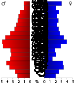
In the county the population was spread out with 21.40% under the age of 18, 7.30% from 18 to 24, 27.10% from 25 to 44, 23.80% from 45 to 64, and 20.40% who were 65 years of age or older. The median age was 42 years. For every 100 females there were 111.90 males. For every 100 females age 18 and over, there were 114.10 males.
The median income for a household
in the county was $35,772, and the median income for a family was $44,360. Males had a median income of $30,110 versus $20,486 for females. The per capita income
for the county was $16,569. About 4.00% of families and 7.20% of the population were below the poverty line, including 7.50% of those under age 18 and 11.10% of those age 65 or over.
 Name and population (2004 estimate):
. The city of Ellsworth
is considered governmentally independent and is excluded from the census figures for the townships. In the following table, the population center is the largest city (or cities) included in that township's population total, if it is of a significant size.
Additional information
Maps
Kansas
Kansas is a US state located in the Midwestern United States. It is named after the Kansas River which flows through it, which in turn was named after the Kansa Native American tribe, which inhabited the area. The tribe's name is often said to mean "people of the wind" or "people of the south...
, in the Central
Central United States
The Central United States is sometimes conceived as between the Eastern United States and Western United States as part of a three-region model, roughly coincident with the Midwestern United States plus the western and central portions of the Southern United States; the term is also sometimes used...
United States
United States
The United States of America is a federal constitutional republic comprising fifty states and a federal district...
. As of the 2010 census, the county population was 6,497. Its county seat
County seat
A county seat is an administrative center, or seat of government, for a county or civil parish. The term is primarily used in the United States....
and most populous city is Ellsworth
Ellsworth, Kansas
Ellsworth is a city in and the county seat of Ellsworth County, Kansas, United States. As of the 2010 census, the city population was 3,120.-19th century:...
.
19th century
Ellsworth County was established February 26, 1867. The county was named after the old Fort Ellsworth, which was named in honor of 2nd Lieutenant Allen Ellsworth of the 7th Iowa Cavalry (Company H), who supervised construction of the fort in 1864. On November 17, 1866, the fort was renamed Fort HarkerFort Harker (Kansas)
Fort Harker, located in Kanopolis, Kansas, was an active military installation of the United States Army from November 17, 1866 to October 5, 1872. The fortification was named after General Charles Garrison Harker, who was killed in action at the Battle of Kennesaw Mountain in the American Civil War...
in honor of General Charles Garrison Harker
Charles Garrison Harker
Charles Garrison Harker was a brigadier general in the Union Army during the American Civil War. He was killed in action at the Battle of Kennesaw Mountain in northern Georgia during the Atlanta Campaign...
who had died on June 27, 1864, from wounds received in an abortive offensive action in the Battle of Kennesaw Mountain
Battle of Kennesaw Mountain
The Battle of Kennesaw Mountain was fought on June 27, 1864, during the Atlanta Campaign of the American Civil War. It was the most significant frontal assault launched by Union Maj. Gen. William T. Sherman against the Confederate Army of Tennessee under Gen. Joseph E...
. The fort was subsequently moved to a new site about one mile to the northeast, and the old fort's remaining buildings were ordered torn down in June 1867.
Law and government
Ellsworth County was a prohibition, or "dry"Dry county
A dry county is a county in the United States whose government forbids the sale of alcoholic beverages. Some prohibit off-premises sale, some prohibit on-premises sale, and some prohibit both. Hundreds of dry counties exist across the United States, almost all of them in the South...
, county until the Kansas Constitution was amended in 1986 and voters approved the sale of alcoholic liquor by the individual drink with a 30% food sales requirement.
Geography
According to the 2000 census, the county has a total area of 723.44 square miles (1,873.7 km²), of which 715.91 square miles (1,854.2 km²) (or 98.96%) is land and 7.54 square miles (19.5 km²) (or 1.04%) is water.Adjacent counties
- Lincoln CountyLincoln County, KansasLincoln County is a county located in the U.S. state of Kansas. As of the 2010 census, the county population was 3,241...
(north) - Saline CountySaline County, KansasSaline County is a county located in the U.S. state of Kansas. As of the 2010 census, the county population was 55,606...
(east) - McPherson CountyMcPherson County, KansasMcPherson County is a county located in the U.S. state of Kansas. As of the 2010 census, the county population was 29,180. The largest city and county seat is McPherson. The county is named for Civil War General James B. McPherson...
(southeast) - Rice CountyRice County, KansasRice County is a county located in the U.S. state of Kansas; it was named in memory of Samuel Allen Rice, Brigadier-General, United States volunteers, killed April 30, 1864, at Jenkins Ferry, Arkansas. As of the 2010 census, the county population was 10,083...
(south) - Barton CountyBarton County, KansasBarton County is a county located in Western Kansas, in the Central United States. As of the 2010 census, the county population was 27,674. Its county seat and most populous city is Great Bend. The county is named in honor of Clara Barton, responsible for the founding of the American Red Cross...
(southwest) - Russell CountyRussell County, KansasRussell County is a county located in the U.S. state of Kansas. The county's population was 6,970 for the 2010 census...
(northwest)
Demographics
As of the U.S. Census in 2000
United States Census, 2000
The Twenty-second United States Census, known as Census 2000 and conducted by the Census Bureau, determined the resident population of the United States on April 1, 2000, to be 281,421,906, an increase of 13.2% over the 248,709,873 persons enumerated during the 1990 Census...
, there were 6,525 people, 2,481 households, and 1,639 families residing in the county. The population density
Population density
Population density is a measurement of population per unit area or unit volume. It is frequently applied to living organisms, and particularly to humans...
was 9 people per square mile (4/km²). There were 3,228 housing units at an average density of 4 per square mile (2/km²). The racial makeup
Race (United States Census)
Race and ethnicity in the United States Census, as defined by the Federal Office of Management and Budget and the United States Census Bureau, are self-identification data items in which residents choose the race or races with which they most closely identify, and indicate whether or not they are...
of the county was 93.67% White
White American
White Americans are people of the United States who are considered or consider themselves White. The United States Census Bureau defines White people as those "having origins in any of the original peoples of Europe, the Middle East, or North Africa...
, 3.56% Black or African American
African American
African Americans are citizens or residents of the United States who have at least partial ancestry from any of the native populations of Sub-Saharan Africa and are the direct descendants of enslaved Africans within the boundaries of the present United States...
, 0.48% Native American
Native Americans in the United States
Native Americans in the United States are the indigenous peoples in North America within the boundaries of the present-day continental United States, parts of Alaska, and the island state of Hawaii. They are composed of numerous, distinct tribes, states, and ethnic groups, many of which survive as...
, 0.25% Asian
Asian American
Asian Americans are Americans of Asian descent. The U.S. Census Bureau definition of Asians as "Asian” refers to a person having origins in any of the original peoples of the Far East, Southeast Asia, or the Indian subcontinent, including, for example, Cambodia, China, India, Indonesia, Japan,...
, 0.02% Pacific Islander
Pacific Islander American
Pacific Islander Americans, also known as Oceanian Americans, are residents of the United States with original ancestry from Oceania. They represent the smallest racial group counted in the United States census of 2000. They numbered 874,000 people or 0.3 percent of the United States population...
, 0.86% from other races, and 1.18% from two or more races
Multiracial
The terms multiracial and mixed-race describe people whose ancestries come from multiple races. Unlike the term biracial, which often is only used to refer to having parents or grandparents of two different races, the term multiracial may encompass biracial people but can also include people with...
. Hispanic
Hispanic
Hispanic is a term that originally denoted a relationship to Hispania, which is to say the Iberian Peninsula: Andorra, Gibraltar, Portugal and Spain. During the Modern Era, Hispanic sometimes takes on a more limited meaning, particularly in the United States, where the term means a person of ...
or Latino
Latino
The demonyms Latino and Latina , are defined in English language dictionaries as:* "a person of Latin-American descent."* "A Latin American."* "A person of Hispanic, especially Latin-American, descent, often one living in the United States."...
of any race were 3.59% of the population.
There were 2,481 household
Household
The household is "the basic residential unit in which economic production, consumption, inheritance, child rearing, and shelter are organized and carried out"; [the household] "may or may not be synonymous with family"....
s out of which 27.90% had children under the age of 18 living with them, 57.20% were married couples
Marriage
Marriage is a social union or legal contract between people that creates kinship. It is an institution in which interpersonal relationships, usually intimate and sexual, are acknowledged in a variety of ways, depending on the culture or subculture in which it is found...
living together, 6.20% had a female householder with no husband present, and 33.90% were non-families. 31.40% of all households were made up of individuals and 17.30% had someone living alone who was 65 years of age or older. The average household size was 2.30 and the average family size was 2.88.
In the county the population was spread out with 21.40% under the age of 18, 7.30% from 18 to 24, 27.10% from 25 to 44, 23.80% from 45 to 64, and 20.40% who were 65 years of age or older. The median age was 42 years. For every 100 females there were 111.90 males. For every 100 females age 18 and over, there were 114.10 males.
The median income for a household
Median household income
The median household income is commonly used to generate data about geographic areas and divides households into two equal segments with the first half of households earning less than the median household income and the other half earning more...
in the county was $35,772, and the median income for a family was $44,360. Males had a median income of $30,110 versus $20,486 for females. The per capita income
Per capita income
Per capita income or income per person is a measure of mean income within an economic aggregate, such as a country or city. It is calculated by taking a measure of all sources of income in the aggregate and dividing it by the total population...
for the county was $16,569. About 4.00% of families and 7.20% of the population were below the poverty line, including 7.50% of those under age 18 and 11.10% of those age 65 or over.
Incorporated cities
- EllsworthEllsworth, KansasEllsworth is a city in and the county seat of Ellsworth County, Kansas, United States. As of the 2010 census, the city population was 3,120.-19th century:...
, 2,883 (county seat) - WilsonWilson, KansasWilson is a city in Ellsworth County, Kansas, United States. As of the 2010 census, the city population was 781.-History:The Butterfield Overland Despatch built a stagecoach station one-half mile south of present-day Wilson in 1865. Three years later, the Kansas Pacific Railway built Wilson...
, 766 - KanopolisKanopolis, KansasKanopolis is a city in Ellsworth County, Kansas, United States. The town is built on the site of Fort Harker, a United States Army post that housed infantry and cavalry troops involved in the Indian Wars from 1867 to 1872. As of the 2010 census, the city population was 492.- History :Fort...
, 522 - HolyroodHolyrood, KansasHolyrood is a city in Ellsworth County, Kansas, United States. As of the 2010 census, the city population was 447.-Geography:Holyrood is located at . According to the United States Census Bureau, the city has a total area of , all land.-Demographics:As of the census of 2000, there were 464...
, 453 - LorraineLorraine, KansasLorraine is a city in Ellsworth County, Kansas, United States. As of the 2010 census, the city population was 138.-Geography:Lorraine is located at . According to the United States Census Bureau, the city has a total area of , all of it land.-Demographics:As of the census of 2000, there were 136...
, 133
Unincorporated places
- Arcola
- Black Wolf
- Carnelro
- Langley
- Terra Cotta
- Venango
- Yankee Run
Townships
Ellsworth County is divided into nineteen townshipsCivil township
A civil township is a widely used unit of local government in the United States, subordinate to, and geographic divisions of, a county. Specific responsibilities and the degree of autonomy vary based on each state. Civil townships are distinct from survey townships, but in states that have both,...
. The city of Ellsworth
Ellsworth, Kansas
Ellsworth is a city in and the county seat of Ellsworth County, Kansas, United States. As of the 2010 census, the city population was 3,120.-19th century:...
is considered governmentally independent and is excluded from the census figures for the townships. In the following table, the population center is the largest city (or cities) included in that township's population total, if it is of a significant size.
| Township | FIPS | Population center |
Population | Population density /km² (/sq mi) |
Land area km² (sq mi) | Water area km² (sq mi) | Water % | Geographic coordinates |
|---|---|---|---|---|---|---|---|---|
| Ash Creek | 02575 | 58 | 1 (2) | 93 (36) | 0 (0) | 0.51% | 38°39′17"N 98°12′47"W | |
| Black Wolf | 07025 | 87 | 1 (2) | 94 (36) | 0 (0) | 0.10% | 38°44′40"N 98°19′33"W | |
| Carneiro | 10800 | 57 | 1 (2) | 93 (36) | 0 (0) | 0.36% | 38°45′2"N 97°59′46"W | |
| Clear Creek | 13725 | 91 | 1 (3) | 94 (36) | 0 (0) | 0.17% | 38°44′10"N 98°6′16"W | |
| Columbia | 15025 | 60 | 1 (2) | 94 (36) | 0 (0) | 0.04% | 38°50′5"N 98°18′50"W | |
| Ellsworth | 20525 | 797 | 9 (23) | 88 (34) | 0 (0) | 0.23% | 38°43′6"N 98°10′58"W | |
| Empire | 21150 | 174 | 1 (3) | 171 (66) | 14 (6) | 7.79% | 38°39′6"N 98°1′7"W | |
| Garfield | 25575 | 27 | 0 (1) | 92 (36) | 0 (0) | 0.30% | 38°50′9"N 98°6′42"W | |
| Green Garden | 28600 | 211 | 2 (6) | 94 (36) | 0 (0) | 0.22% | 38°33′30"N 98°19′19"W | |
| Langley | 38600 | 76 | 1 (2) | 92 (35) | 2 (1) | 1.86% | 38°35′33"N 97°58′15"W | |
| Lincoln | 40675 | 62 | 1 (2) | 95 (37) | 0 (0) | 0.22% | 38°39′8"N 98°18′0"W | |
| Mulberry | 49050 | 44 | 0 (1) | 93 (36) | 0 (0) | 0.24% | 38°50′5"N 97°58′28"W | |
| Noble | 50825 | 90 | 1 (3) | 93 (36) | 0 (0) | 0.04% | 38°44′51"N 98°25′33"W | |
| Palacky | 54100 | 63 | 1 (2) | 94 (36) | 0 (0) | 0.08% | 38°38′51"N 98°25′56"W | |
| Sherman | 64950 | 65 | 1 (2) | 94 (36) | 0 (0) | 0.22% | 38°49′21"N 98°13′7"W | |
| Thomas | 70450 | 72 | 1 (2) | 93 (36) | 0 (0) | 0.21% | 38°33′56"N 98°11′33"W | |
| Trivoli | 71525 | 55 | 1 (2) | 93 (36) | 0 (0) | 0.38% | 38°35′7"N 98°4′23"W | |
| Valley | 72800 | 577 | 6 (16) | 93 (36) | 0 (0) | 0.14% | 38°34′22"N 98°24′56"W | |
| Wilson | 79700 | Wilson Wilson, Kansas Wilson is a city in Ellsworth County, Kansas, United States. As of the 2010 census, the city population was 781.-History:The Butterfield Overland Despatch built a stagecoach station one-half mile south of present-day Wilson in 1865. Three years later, the Kansas Pacific Railway built Wilson... |
894 | 10 (25) | 93 (36) | 0 (0) | 0.06% | 38°49′34"N 98°27′23"W |
| Sources: | ||||||||
Unified school districts
See also
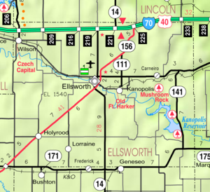
- Mushroom Rock State ParkMushroom Rock State ParkMushroom Rock State Park, located in the Smoky Hills region of Kansas, is noted for its mushroom rock formations. These rocks were formed through a process of nonuniform erosion and weathering in which a hard mass of Dakota Sandstone resisted erosion while the underlying softer stone weathered...
- National Register of Historic Places listings in Ellsworth County, KansasNational Register of Historic Places listings in Ellsworth County, KansasThis is a list of the National Register of Historic Places listings in Ellsworth County, Kansas.This is intended to be a complete list of the properties and districts on the National Register of Historic Places in Ellsworth County, Kansas, United States...
Further reading
- History of the State of Kansas; William G. Cutler; A.T. Andreas Publisher; 1883. (Online HTML eBook)
- Kansas : A Cyclopedia of State History, Embracing Events, Institutions, Industries, Counties, Cities, Towns, Prominent Persons, Etc; 3 Volumes; Frank W. Blackmar; Standard Publishing Co; 944 / 955 / 824 pages; 1912. (Volume1 - Download 54MB PDF eBook),(Volume2 - Download 53MB PDF eBook), (Volume3 - Download 33MB PDF eBook)
External links
Official sites- Ellsworth County
- Ellsworth County - Directory of Public Officials
- Ellsworth County Independent Reporter (local newspaper)
Additional information
Maps
- Ellsworth County Map, KDOT
- Kansas Highway Map, KDOT
- Kansas Railroad Map, KDOT
- Kansas School District Boundary Map, KSDE