
Washington County, Minnesota
Encyclopedia
Washington County is a county established in 1849 in the U.S. state
of Minnesota
. As of 2010, the population was 238,136. Its county seat
is Stillwater
.
was organized in 1849. The county was officially established October 27, 1849, named after George Washington
.
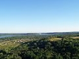
 Early development in the area was on the St. Croix River
, which forms the eastern boundary of the county. The river not only provided a means of transportation to move people upstream, but also move logs downstream. The area was heavily forested and the early economy was dependent on the logging and lumber industries.
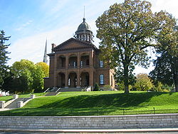
The first settlement and seat was named Dacotah, and was located as early as 1838 in what is now north Stillwater, where Brown's Creek
flows into the St. Croix River. The creek's name is from the founder of this settlement, Joseph Renshaw Brown. However, a sawmill
was built at Marine-on-St.-Croix
in 1839, and another was built in the current location of downtown Stillwater in 1844. The success of these soon attracted the settlers from Dacotah, and Stillwater became the county seat in 1846.
During this early period, the region was part of the Wisconsin Territory, but Wisconsin
became a state in 1848. Brown and other leaders called together settlers in this now-ungoverned territory to what has become known as the “Stillwater Convention "on August 26, 1848. Held in John McKusick’s store, the settlers drafted a Memorial to Congress that a new territory be created with the name “Minnesota,” and elected Henry Hastings Sibley
to deliver this citizen’s petition to the U.S. Congress. Because of this convention, Stillwater calls itself the “Birthplace of Minnesota.”
After officially becoming a territory, growth continued, with the first Sheriff of Washington County appointed by Governor Alexander Ramsey
in 1849, and the county's school district founded in 1850.
After the forests were depleted, the economy of Washington County became primarily agricultural. With the growth of neighboring Ramsey County
and St. Paul, some of Washington County developed based on tourism and recreation, as with Mahtomedi
and Landfall
. Late in the 20th century, the population greatly increased with the suburban expansion of St. Paul.
of 2000, there were 201,130 people, 71,462 households, and 54,668 families residing in the county. The population density
was 514 people per square mile (198/km²). There were 73,635 housing units at an average density of 188 per square mile (73/km²). The racial makeup of the county was 93.63% White
, 1.83% Black
or African American
, 0.39% Native American
, 2.14% Asian
, 0.03% Pacific Islander
, 0.60% from other races
, and 1.37% from two or more races. 1.94% of the population were Hispanic
or Latino
of any race. 32.7% were of German, 11.1% Norwegian, 9.8% Irish
and 7.5% Swedish ancestry according to Census 2000.
There were 71,462 households out of which 41.60% had children under the age of 18 living with them, 64.80% were married couples
living together, 8.50% had a female householder with no husband present, and 23.50% were non-families. 18.70% of all households were made up of individuals and 5.40% had someone living alone who was 65 years of age or older. The average household size was 2.77 and the average family size was 3.19.
In the county the population was spread out with 29.40% under the age of 18, 6.80% from 18 to 24, 32.90% from 25 to 44, 23.20% from 45 to 64, and 7.60% who were 65 years of age or older. The median age was 35 years. For every 100 females there were 98.80 males. For every 100 females age 18 and over, there were 96.80 males.
The median income for a household in the county was $66,305, and the median income for a family was $74,576 (these figures had risen to $78,067 and $90,867 respectively as of a 2007 estimate). Males had a median income of $49,815 versus $33,804 for females. The per capita income
for the county was $28,148. About 2.00% of families and 2.90% of the population were below the poverty line, including 3.50% of those under age 18 and 4.10% of those age 65 or over.
† Hastings is the county seat of Dakota County
, but a small part extends into Washington County.
‡ in Ramsey County
, a small part extends into Washington County.
U.S. state
A U.S. state is any one of the 50 federated states of the United States of America that share sovereignty with the federal government. Because of this shared sovereignty, an American is a citizen both of the federal entity and of his or her state of domicile. Four states use the official title of...
of Minnesota
Minnesota
Minnesota is a U.S. state located in the Midwestern United States. The twelfth largest state of the U.S., it is the twenty-first most populous, with 5.3 million residents. Minnesota was carved out of the eastern half of the Minnesota Territory and admitted to the Union as the thirty-second state...
. As of 2010, the population was 238,136. Its county seat
County seat
A county seat is an administrative center, or seat of government, for a county or civil parish. The term is primarily used in the United States....
is Stillwater
Stillwater, Minnesota
As of the census of 2000, there were 15,143 people, 5,797 households, and 4,115 families residing in the city. The population density was 2,340.0 people per square mile . There were 5,926 housing units at an average density of 915.7 per square mile...
.
History
Washington County was one of the nine original counties created when the Minnesota TerritoryMinnesota Territory
The Territory of Minnesota was an organized incorporated territory of the United States that existed from March 3, 1849, until May 11, 1858, when the eastern portion of the territory was admitted to the Union as the State of Minnesota.-History:...
was organized in 1849. The county was officially established October 27, 1849, named after George Washington
George Washington
George Washington was the dominant military and political leader of the new United States of America from 1775 to 1799. He led the American victory over Great Britain in the American Revolutionary War as commander-in-chief of the Continental Army from 1775 to 1783, and presided over the writing of...
.
St. Croix River (Wisconsin-Minnesota)
The St. Croix River is a tributary of the Mississippi River, approximately long, in the U.S. states of Wisconsin and Minnesota. The lower of the river form the border between Wisconsin and Minnesota. The river is a National Scenic Riverway under the protection of the National Park Service. A...
, which forms the eastern boundary of the county. The river not only provided a means of transportation to move people upstream, but also move logs downstream. The area was heavily forested and the early economy was dependent on the logging and lumber industries.
The first settlement and seat was named Dacotah, and was located as early as 1838 in what is now north Stillwater, where Brown's Creek
Brown's Creek (St. Croix River)
Brown's Creek is a stream which originates about 5.5 miles northwest of the city of Stillwater and flows south for about half its length then east to its confluence with the St. Croix River just north of Stillwater in Washington County, Minnesota, United States...
flows into the St. Croix River. The creek's name is from the founder of this settlement, Joseph Renshaw Brown. However, a sawmill
Sawmill
A sawmill is a facility where logs are cut into boards.-Sawmill process:A sawmill's basic operation is much like those of hundreds of years ago; a log enters on one end and dimensional lumber exits on the other end....
was built at Marine-on-St.-Croix
Marine on St. Croix, Minnesota
Marine on St. Croix is a city in Washington County, Minnesota, United States. The population was 689 at the 2010 census.-Geography:According to the United States Census Bureau, the city has a total area of , of which, of it is land and of it is water. Minnesota State Highway 95 serves as a main...
in 1839, and another was built in the current location of downtown Stillwater in 1844. The success of these soon attracted the settlers from Dacotah, and Stillwater became the county seat in 1846.
During this early period, the region was part of the Wisconsin Territory, but Wisconsin
Wisconsin
Wisconsin is a U.S. state located in the north-central United States and is part of the Midwest. It is bordered by Minnesota to the west, Iowa to the southwest, Illinois to the south, Lake Michigan to the east, Michigan to the northeast, and Lake Superior to the north. Wisconsin's capital is...
became a state in 1848. Brown and other leaders called together settlers in this now-ungoverned territory to what has become known as the “Stillwater Convention "on August 26, 1848. Held in John McKusick’s store, the settlers drafted a Memorial to Congress that a new territory be created with the name “Minnesota,” and elected Henry Hastings Sibley
Henry Hastings Sibley
Henry Hastings Sibley was the first Governor of the U.S. state of Minnesota.-Early life and education:...
to deliver this citizen’s petition to the U.S. Congress. Because of this convention, Stillwater calls itself the “Birthplace of Minnesota.”
After officially becoming a territory, growth continued, with the first Sheriff of Washington County appointed by Governor Alexander Ramsey
Alexander Ramsey
Alexander Ramsey was an American politician. He was born near Harrisburg, Pennsylvania.Alexander Ramsey was elected from Pennsylvania as a Whig to the U.S. House of Representatives and served in the 28th and 29th congresses from March 4, 1843 to March 4, 1847...
in 1849, and the county's school district founded in 1850.
After the forests were depleted, the economy of Washington County became primarily agricultural. With the growth of neighboring Ramsey County
Ramsey County, Minnesota
Ramsey County is a county located in the U.S. state of Minnesota, founded in 1849. As of 2010, the population was 508,640. Its county seat is St. Paul, which is also Minnesota's state capital. The county is named for Alexander Ramsey , the first governor of the Minnesota Territory...
and St. Paul, some of Washington County developed based on tourism and recreation, as with Mahtomedi
Mahtomedi, Minnesota
As of the census of 2000, there were 7,563 people, 2,503 households, and 2,027 families residing in the city. The population density was 2,095.4 people per square mile . There were 2,581 housing units at an average density of 715.1 per square mile...
and Landfall
Landfall, Minnesota
Landfall is a city in Washington County, Minnesota, United States. The population was 686 at the 2010 census and is the smallest community in Washington County in terms of area. It lies on the eastern shore of Tanner's Lake on Interstate 94....
. Late in the 20th century, the population greatly increased with the suburban expansion of St. Paul.
Geography
According to the 2000 census, the county has a total area of 423.16 square miles (1,096 km²), of which 391.7 square miles (1,014.5 km²) (or 92.57%) is land and 31.46 square miles (81.5 km²) (or 7.43%) is water.Major highways
|
 Minnesota State Highway 5 Minnesota State Highway 5Minnesota State Highway 5 Minnesota State Highway 5 is a highway in Minnesota, which runs from its intersection with State Highways 19 and 22 in Gaylord and continues east and northeast to its eastern terminus at its interchange with State Highway 36 and Washington County Road 5 in Stillwater...  Minnesota State Highway 36 Minnesota State Highway 36Minnesota State Highway 36 Minnesota State Highway 36 is a highway in Minnesota, which runs from its interchange with Interstate 35W in Roseville and continues east to its eastern terminus at the Wisconsin state line , where it becomes Wisconsin Highway 64 upon crossing the St. Croix River...  Minnesota State Highway 95 Minnesota State Highway 95Minnesota State Highway 95 Minnesota State Highway 95 is a highway in east-central Minnesota, which runs from its intersection with State Highway 23 near St. Cloud and continues east and south to its southern terminus at its intersection with U.S...  Minnesota State Highway 96 Minnesota State Highway 96Minnesota State Highway 96 Minnesota State Highway 96 is a highway in Minnesota, which runs from its intersection with U.S. Highway 61 in White Bear Lake and continues east to its eastern terminus at its intersection with State Highway 95 on the northern edge of Stillwater....  Minnesota State Highway 97 Minnesota State Highway 97Minnesota State Highway 97 Minnesota State Highway 97 is a highway in Minnesota, which runs from its junction with Interstate 35 and Anoka County Road 23 in Columbus, near Forest Lake, and continues east to its eastern terminus at its intersection with State Highway 95 in Scandia, near Marine on St...  Minnesota State Highway 120 Minnesota State Highway 120Minnesota State Highway 120 Minnesota State Highway 120 is a highway in Minnesota, which runs from its interchange with Interstate Highway 94 in Maplewood and continues north to its northern terminus at its intersection with State Highway 244 and Ramsey County Road 15 at the White Bear Lake / Mahtomedi boundary line...  Minnesota State Highway 244 Minnesota State Highway 244Minnesota State Highway 244 Minnesota State Highway 244 is a highway in Minnesota, which runs from its intersection with State Highway 120 and Ramsey County Road 15 at the White Bear Lake / Mahtomedi city boundary line and continues briefly east and then north to its northern terminus at its intersection with State Highway... |


 U.S. Highway 8
 U.S. Highway 10
 U.S. Highway 12
 U.S. Highway 61
Adjacent counties
- Chisago County (north)
- Polk County, Wisconsin (northeast)
- St. Croix County, WisconsinSt. Croix County, WisconsinSt. Croix County is a county in the U.S. state of Wisconsin. As of 2010, the population was 84,345. Its county seat is Hudson. St. Croix County is part of the Minneapolis-St. Paul Metropolitan Statistical Area . It is the fastest growing county in Wisconsin.-Geography:According to the U.S...
(east) - Pierce County, WisconsinPierce County, WisconsinPierce County is a county located in the U.S. state of Wisconsin. As of 2010, the population was 41,019. Its county seat is Ellsworth. Pierce County is part of the Minneapolis-St. Paul-Bloomington, MN-WI Metropolitan Statistical Area .-Geography:...
(southeast) - Dakota CountyDakota County, MinnesotaDakota County is the third most populous county in the U.S. state of Minnesota. The county is bordered by the Minnesota and Mississippi Rivers on the north, and the state of Wisconsin on the east. Dakota County comprises the southeast portion of seven-county Minneapolis-St. Paul, the thirteenth...
(southwest) - Ramsey CountyRamsey County, MinnesotaRamsey County is a county located in the U.S. state of Minnesota, founded in 1849. As of 2010, the population was 508,640. Its county seat is St. Paul, which is also Minnesota's state capital. The county is named for Alexander Ramsey , the first governor of the Minnesota Territory...
(west) - Anoka CountyAnoka County, MinnesotaAnoka County is the fourth-most populous county in the U.S. state of Minnesota. The county is bordered by the counties of Isanti on the north, Chisago and Washington on the east, Hennepin and Ramsey on the south, Sherburne on the west, and the Mississippi River on the southwest.As of 2010, Anoka...
(northwest)
National protected areas
- Mississippi National River and Recreation AreaMississippi National River and Recreation AreaThe Mississippi National River and Recreation Area protects a and corridor along the Mississippi River from the cities of Dayton and Ramsey, Minnesota to just downstream of Hastings, Minnesota. This includes the stretch of Mississippi River which flows through Minneapolis and St. Paul, Minnesota...
(part) - Saint Croix National Scenic RiverwaySaint Croix National Scenic RiverwayThe Saint Croix National Scenic Riverway is a federally protected system of riverways located in eastern Minnesota and northwestern Wisconsin. It protects of river, including the St. Croix River , and the Namekagon River , as well as adjacent land along the rivers. The St...
(part)
Demographics
As of the censusCensus
A census is the procedure of systematically acquiring and recording information about the members of a given population. It is a regularly occurring and official count of a particular population. The term is used mostly in connection with national population and housing censuses; other common...
of 2000, there were 201,130 people, 71,462 households, and 54,668 families residing in the county. The population density
Population density
Population density is a measurement of population per unit area or unit volume. It is frequently applied to living organisms, and particularly to humans...
was 514 people per square mile (198/km²). There were 73,635 housing units at an average density of 188 per square mile (73/km²). The racial makeup of the county was 93.63% White
Race (United States Census)
Race and ethnicity in the United States Census, as defined by the Federal Office of Management and Budget and the United States Census Bureau, are self-identification data items in which residents choose the race or races with which they most closely identify, and indicate whether or not they are...
, 1.83% Black
Race (United States Census)
Race and ethnicity in the United States Census, as defined by the Federal Office of Management and Budget and the United States Census Bureau, are self-identification data items in which residents choose the race or races with which they most closely identify, and indicate whether or not they are...
or African American
Race (United States Census)
Race and ethnicity in the United States Census, as defined by the Federal Office of Management and Budget and the United States Census Bureau, are self-identification data items in which residents choose the race or races with which they most closely identify, and indicate whether or not they are...
, 0.39% Native American
Race (United States Census)
Race and ethnicity in the United States Census, as defined by the Federal Office of Management and Budget and the United States Census Bureau, are self-identification data items in which residents choose the race or races with which they most closely identify, and indicate whether or not they are...
, 2.14% Asian
Race (United States Census)
Race and ethnicity in the United States Census, as defined by the Federal Office of Management and Budget and the United States Census Bureau, are self-identification data items in which residents choose the race or races with which they most closely identify, and indicate whether or not they are...
, 0.03% Pacific Islander
Race (United States Census)
Race and ethnicity in the United States Census, as defined by the Federal Office of Management and Budget and the United States Census Bureau, are self-identification data items in which residents choose the race or races with which they most closely identify, and indicate whether or not they are...
, 0.60% from other races
Race (United States Census)
Race and ethnicity in the United States Census, as defined by the Federal Office of Management and Budget and the United States Census Bureau, are self-identification data items in which residents choose the race or races with which they most closely identify, and indicate whether or not they are...
, and 1.37% from two or more races. 1.94% of the population were Hispanic
Race (United States Census)
Race and ethnicity in the United States Census, as defined by the Federal Office of Management and Budget and the United States Census Bureau, are self-identification data items in which residents choose the race or races with which they most closely identify, and indicate whether or not they are...
or Latino
Race (United States Census)
Race and ethnicity in the United States Census, as defined by the Federal Office of Management and Budget and the United States Census Bureau, are self-identification data items in which residents choose the race or races with which they most closely identify, and indicate whether or not they are...
of any race. 32.7% were of German, 11.1% Norwegian, 9.8% Irish
Irish people
The Irish people are an ethnic group who originate in Ireland, an island in northwestern Europe. Ireland has been populated for around 9,000 years , with the Irish people's earliest ancestors recorded having legends of being descended from groups such as the Nemedians, Fomorians, Fir Bolg, Tuatha...
and 7.5% Swedish ancestry according to Census 2000.
There were 71,462 households out of which 41.60% had children under the age of 18 living with them, 64.80% were married couples
Marriage
Marriage is a social union or legal contract between people that creates kinship. It is an institution in which interpersonal relationships, usually intimate and sexual, are acknowledged in a variety of ways, depending on the culture or subculture in which it is found...
living together, 8.50% had a female householder with no husband present, and 23.50% were non-families. 18.70% of all households were made up of individuals and 5.40% had someone living alone who was 65 years of age or older. The average household size was 2.77 and the average family size was 3.19.
In the county the population was spread out with 29.40% under the age of 18, 6.80% from 18 to 24, 32.90% from 25 to 44, 23.20% from 45 to 64, and 7.60% who were 65 years of age or older. The median age was 35 years. For every 100 females there were 98.80 males. For every 100 females age 18 and over, there were 96.80 males.
The median income for a household in the county was $66,305, and the median income for a family was $74,576 (these figures had risen to $78,067 and $90,867 respectively as of a 2007 estimate). Males had a median income of $49,815 versus $33,804 for females. The per capita income
Per capita income
Per capita income or income per person is a measure of mean income within an economic aggregate, such as a country or city. It is calculated by taking a measure of all sources of income in the aggregate and dividing it by the total population...
for the county was $28,148. About 2.00% of families and 2.90% of the population were below the poverty line, including 3.50% of those under age 18 and 4.10% of those age 65 or over.
Communities
| Cities | Townships | Ghost towns | |
|---|---|---|---|
|
Landfall, Minnesota Landfall is a city in Washington County, Minnesota, United States. The population was 686 at the 2010 census and is the smallest community in Washington County in terms of area. It lies on the eastern shore of Tanner's Lake on Interstate 94.... Mahtomedi, Minnesota As of the census of 2000, there were 7,563 people, 2,503 households, and 2,027 families residing in the city. The population density was 2,095.4 people per square mile . There were 2,581 housing units at an average density of 715.1 per square mile... Marine on St. Croix, Minnesota Marine on St. Croix is a city in Washington County, Minnesota, United States. The population was 689 at the 2010 census.-Geography:According to the United States Census Bureau, the city has a total area of , of which, of it is land and of it is water. Minnesota State Highway 95 serves as a main... Newport, Minnesota Newport is a city in Washington County, Minnesota, United States. The population was 3,435 at the 2010 census.-Geography:According to the United States Census Bureau, the city has a total area of , of which, of it is land and of it is water.... Oak Park Heights, Minnesota Oak Park Heights is a city in Washington County, Minnesota, United States. The population was 4,339 at the 2010 census.-Geography:According to the United States Census Bureau, the city has a total area of , all land... Oakdale, Minnesota As of the census of 2000, there were 26,653 people, 10,243 households, and 7,129 families residing in the city. The population density was 2,408.4 people per square mile . There were 10,394 housing units at an average density of 939.2 per square mile... Pine Springs, Minnesota Pine Springs is a city in Washington County, Minnesota, United States. The population was 408 at the 2010 census.-Geography:According to the United States Census Bureau, the city has a total area of , of which, of it is land and of it is water... St. Marys Point, Minnesota St. Marys Point is a city in Washington County, Minnesota, United States. The population was 368 at the 2010 census.-Geography:According to the United States Census Bureau, the city has a total area of , all of it land. County 18 serves as a main route.... St. Paul Park, Minnesota St. Paul Park is a city in Washington County, Minnesota, United States. The population was 5,279 at the 2010 census. It is located on the Mississippi River five miles downstream from St... Stillwater, Minnesota As of the census of 2000, there were 15,143 people, 5,797 households, and 4,115 families residing in the city. The population density was 2,340.0 people per square mile . There were 5,926 housing units at an average density of 915.7 per square mile... Willernie, Minnesota Willernie is a city in Washington County, Minnesota, United States. It is bordered on all sides by the city of Mahtomedi. The population was 507 at the 2010 census.-Geography:... White Bear Lake, Minnesota White Bear Lake is a city in Ramsey and Washington counties in the U.S. state of Minnesota. The population was 23,797 at the 2010 census. The city is located on White Bear Lake, one of the largest lakes in the Minneapolis-St... ‡ Woodbury, Minnesota Woodbury is a city in Washington County, Minnesota, United States, and is a suburb of the Twin Cities metropolitan area. It is situated east of Saint Paul along Interstate 94... |
May Township, Washington County, Minnesota May Township is a township in Washington County, Minnesota, United States. The population was 2,928 at the 2000 census.-Geography:According to the United States Census Bureau, the township has a total area of 37.6 square miles , of which, 35.3 square miles of it is land and... |
Garen, Minnesota Garen is an abandoned townsite in Washington County, Minnesota.- History :Garen was a town just south of Forest Lake, Minnesota. It was located on present U.S. Route 61 and 190th Street. Garen South School in District No. 72 opened in 1893. It had 5 grades: A, B, C, D, and E... Point Douglas, Minnesota Point Douglas is a ghost town in section 8 of Denmark Township, Washington County, Minnesota, United States. It is located across the St Croix River from Prescott, Wisconsin.-History:... |
† Hastings is the county seat of Dakota County
Dakota County, Minnesota
Dakota County is the third most populous county in the U.S. state of Minnesota. The county is bordered by the Minnesota and Mississippi Rivers on the north, and the state of Wisconsin on the east. Dakota County comprises the southeast portion of seven-county Minneapolis-St. Paul, the thirteenth...
, but a small part extends into Washington County.
‡ in Ramsey County
Ramsey County, Minnesota
Ramsey County is a county located in the U.S. state of Minnesota, founded in 1849. As of 2010, the population was 508,640. Its county seat is St. Paul, which is also Minnesota's state capital. The county is named for Alexander Ramsey , the first governor of the Minnesota Territory...
, a small part extends into Washington County.
Points of interest
- Afton State ParkAfton State ParkAfton State Park is a state park of Minnesota, USA, on the St. Croix River in Washington County. Its hiking trails offer views of the river, rolling glacial moraine, and bluffland it preserves. It is a popular place for birdwatching, picnics, camping, and other typical outdoor recreational...
- Afton AlpsAfton AlpsAfton Alps is a ski resort, which hosts a collection of ski and snowboard trails, located along the St. Croix River south of Afton, Minnesota in the United States. There are nearly skiiable at Afton Alps. The Alps often utilize artificial snow for maintaining the slopes. A total of 48 trails...
Ski Area - Gateway State TrailGateway State TrailThe Gateway State Trail is a multi-use recreational rail trail in Minnesota, USA, running from Saint Paul to Pine Point Regional Park through urban landscapes of eastern Saint Paul in Ramsey County and rural farmland and forests in Washington County...
- William O'Brien State ParkWilliam O'Brien State ParkWilliam O'Brien State Park is a state park of Minnesota, USA, along the St. Croix River. Its hiking trails traverse rolling glacial moraine, riparian zones, restored oak savanna, wooded areas and bogs...
Regional (County) Parks
- Big Marine Park Reserve
- Cottage Grove Ravine Regional Park
- Lake Elmo Park Reserve
- Pine Point Park
- Point Douglas Park
- St. Croix Bluffs Regional Park
- Square Lake County Park