

Coldwater, Kansas
Encyclopedia
Coldwater is a city in and the county seat
of Comanche County
, Kansas
, United States
. As of the 2010 census, the city population was 828.
, the city has a total area of 3 square miles (7.8 km²), of which, 2.6 square miles (6.7 km²) of it is land and 0.3 square mile (0.776996433 km²) of it (11.45%) is water.
of 2000, there were 792 people, 380 households, and 209 families residing in the city. The population density
was 301.3 people per square mile (116.3/km²). There were 460 housing units at an average density of 175.0 per square mile (67.5/km²). The racial makeup of the city was 98.11% White, 0.13% African American, 0.63% Native American, 0.13% Pacific Islander, 0.13% from other races
, and 0.88% from two or more races. Hispanic or Latino of any race were 2.15% of the population.
There were 380 households out of which 20.3% had children under the age of 18 living with them, 46.6% were married couples
living together, 8.4% had a female householder with no husband present, and 45.0% were non-families. 42.9% of all households were made up of individuals and 28.2% had someone living alone who was 65 years of age or older. The average household size was 2.01 and the average family size was 2.75.
In the city the population was spread out with 20.3% under the age of 18, 5.4% from 18 to 24, 17.9% from 25 to 44, 24.6% from 45 to 64, and 31.7% who were 65 years of age or older. The median age was 50 years. For every 100 females there were 80.8 males. For every 100 females age 18 and over, there were 76.8 males.
The median income for a household in the city was $27,167, and the median income for a family was $36,786. Males had a median income of $23,438 versus $16,625 for females. The per capita income
for the city was $16,851. About 8.7% of families and 9.8% of the population were below the poverty line, including 8.8% of those under age 18 and 8.9% of those age 65 or over.
300.
County
Schools
Photos and Videos
Maps
County seat
A county seat is an administrative center, or seat of government, for a county or civil parish. The term is primarily used in the United States....
of Comanche County
Comanche County, Kansas
Comanche County is a county located in Southwest Kansas, in the Central United States. As of the 2010 census, the county population was 1,891...
, Kansas
Kansas
Kansas is a US state located in the Midwestern United States. It is named after the Kansas River which flows through it, which in turn was named after the Kansa Native American tribe, which inhabited the area. The tribe's name is often said to mean "people of the wind" or "people of the south...
, United States
United States
The United States of America is a federal constitutional republic comprising fifty states and a federal district...
. As of the 2010 census, the city population was 828.
Geography
Coldwater is located at 37°16′10"N 99°19′34"W (37.269553, -99.326061). According to the United States Census BureauUnited States Census Bureau
The United States Census Bureau is the government agency that is responsible for the United States Census. It also gathers other national demographic and economic data...
, the city has a total area of 3 square miles (7.8 km²), of which, 2.6 square miles (6.7 km²) of it is land and 0.3 square mile (0.776996433 km²) of it (11.45%) is water.
Area attractions
- Comanche County Historical Museum, 105 West Main Street.
- Chief Theater (NRHPNational Register of Historic PlacesThe National Register of Historic Places is the United States government's official list of districts, sites, buildings, structures, and objects deemed worthy of preservation...
), 122 East Main Street. - Comanche County Courthouse (NRHPNational Register of Historic PlacesThe National Register of Historic Places is the United States government's official list of districts, sites, buildings, structures, and objects deemed worthy of preservation...
), 201 South New York Avenue.
Demographics
As of the censusCensus
A census is the procedure of systematically acquiring and recording information about the members of a given population. It is a regularly occurring and official count of a particular population. The term is used mostly in connection with national population and housing censuses; other common...
of 2000, there were 792 people, 380 households, and 209 families residing in the city. The population density
Population density
Population density is a measurement of population per unit area or unit volume. It is frequently applied to living organisms, and particularly to humans...
was 301.3 people per square mile (116.3/km²). There were 460 housing units at an average density of 175.0 per square mile (67.5/km²). The racial makeup of the city was 98.11% White, 0.13% African American, 0.63% Native American, 0.13% Pacific Islander, 0.13% from other races
Race (United States Census)
Race and ethnicity in the United States Census, as defined by the Federal Office of Management and Budget and the United States Census Bureau, are self-identification data items in which residents choose the race or races with which they most closely identify, and indicate whether or not they are...
, and 0.88% from two or more races. Hispanic or Latino of any race were 2.15% of the population.
There were 380 households out of which 20.3% had children under the age of 18 living with them, 46.6% were married couples
Marriage
Marriage is a social union or legal contract between people that creates kinship. It is an institution in which interpersonal relationships, usually intimate and sexual, are acknowledged in a variety of ways, depending on the culture or subculture in which it is found...
living together, 8.4% had a female householder with no husband present, and 45.0% were non-families. 42.9% of all households were made up of individuals and 28.2% had someone living alone who was 65 years of age or older. The average household size was 2.01 and the average family size was 2.75.
In the city the population was spread out with 20.3% under the age of 18, 5.4% from 18 to 24, 17.9% from 25 to 44, 24.6% from 45 to 64, and 31.7% who were 65 years of age or older. The median age was 50 years. For every 100 females there were 80.8 males. For every 100 females age 18 and over, there were 76.8 males.
The median income for a household in the city was $27,167, and the median income for a family was $36,786. Males had a median income of $23,438 versus $16,625 for females. The per capita income
Per capita income
Per capita income or income per person is a measure of mean income within an economic aggregate, such as a country or city. It is calculated by taking a measure of all sources of income in the aggregate and dividing it by the total population...
for the city was $16,851. About 8.7% of families and 9.8% of the population were below the poverty line, including 8.8% of those under age 18 and 8.9% of those age 65 or over.
Primary and secondary education
Coldwater is part of Unified School DistrictUnified school district
A unified school district or unit school district is a school district which includes both primary school and high school under the same district control....
300.
Infrastructure
Notable people
- Harold S. HerdHarold S. HerdHarold Shields Herd was a Kansas Supreme Court justice , minority leader in the Kansas State Senate , mayor of Coldwater, Kansas and an officer in the U.S. Navy during World War II....
, former Kansas Supreme CourtKansas Supreme CourtThe Kansas Supreme Court is the highest judicial authority in the state of Kansas. Composed of seven justices, led by Chief Justice Lawton Nuss, the Court supervises the legal profession, administers over the judicial branch, and serves as the state court of last resort in the appeals...
justice, minority leader in the Kansas State Senate, mayor of Coldwater, officer in the U.S. Navy during World War IIWorld War IIWorld War II, or the Second World War , was a global conflict lasting from 1939 to 1945, involving most of the world's nations—including all of the great powers—eventually forming two opposing military alliances: the Allies and the Axis...
.
Further reading
- History of the State of Kansas; William G. Cutler; A.T. Andreas Publisher; 1883. (Online HTML eBook)
- Kansas : A Cyclopedia of State History, Embracing Events, Institutions, Industries, Counties, Cities, Towns, Prominent Persons, Etc; 3 Volumes; Frank W. Blackmar; Standard Publishing Co; 944 / 955 / 824 pages; 1912. (Volume1 - Download 54MB PDF eBook),(Volume2 - Download 53MB PDF eBook), (Volume3 - Download 33MB PDF eBook)
External links
CityCounty
Schools
- USD 300, local school district
Photos and Videos
- KWCH 'One of a Kind' Kansas road trip in 2011: Photos, Video 1, Video 2. Towns included were Coldwater, SterlingSterling, KansasSterling is a city in Rice County, Kansas, United States. As of the 2010 census, the city population was 2,328. Sterling is home to Sterling College.- History :...
, AtwoodAtwood, KansasAtwood is a city in and the county seat of Rawlins County, Kansas, United States. As of the 2010 census, the city population was 1,194.-History:...
, LucasLucas, KansasLucas is a city in Russell County, Kansas, United States. As of the 2010 census, the city population was 393.-Geography:Lucas is located at at an elevation of 1,489 feet . According to the United States Census Bureau, the city has a total area of , all of it land. It lies in the Smoky Hills...
, MarionMarion, KansasMarion is a city in and the county seat of Marion County, Kansas, United States. It was named in honor of Francis Marion, a Brigadier General of the American Revolutionary War, known as the "Swamp Fox". As of the 2010 census, the city population was 1,927....
.
Maps
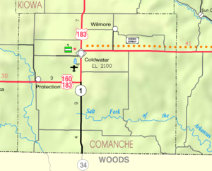
- Coldwater City Map, KDOT
- Comanche County Map, KDOT