
Ford County, Kansas
Encyclopedia
Ford County is a county
located in southwest Kansas
, in the Central
United States
. As of the 2010 census, the county population was 33,848. The Dodge City Micropolitan Statistical Area includes all of Ford County. Its county seat
and most populous city is Dodge City
. The county is named in honor of Colonel
James Hobart Ford
. For a brief time during the American Civil War
he served as a brevet
Major General
. Ford was in charge of the construction of Fort Dodge, Kansas
, after the Civil War.
, county until the Kansas Constitution was amended in 1986 and voters approved the sale of alcoholic liquor by the individual drink with a 30% food sales requirement.
 As of the U.S. Census in 2000
, there were 32,458 people, 10,852 households, and 7,856 families residing in the county. The population density
was 30 people per square mile (11/km²). There were 11,650 housing units at an average density of 11 per square mile (4/km²). The racial makeup
of the county was 74.85% White
, 1.62% Black or African American
, 0.63% Native American
, 2.05% Asian
, 0.12% Pacific Islander
, 18.17% from other races, and 2.56% from two or more races
. Hispanic
or Latino
of any race were 37.68% of the population.
There were 10,852 household
s out of which 40.90% had children under the age of 18 living with them, 57.90% were married couples
living together, 9.20% had a female householder with no husband present, and 27.60% were non-families. 22.70% of all households were made up of individuals and 9.50% had someone living alone who was 65 years of age or older. The average household size was 2.92 and the average family size was 3.42.
In the county the population was spread out with 31.10% under the age of 18, 11.20% from 18 to 24, 29.40% from 25 to 44, 17.30% from 45 to 64, and 11.00% who were 65 years of age or older. The median age was 30 years. For every 100 females there were 107.20 males. For every 100 females age 18 and over, there were 105.30 males.
The median income for a household
in the county was $37,860, and the median income for a family was $42,734. Males had a median income of $27,189 versus $22,165 for females. The per capita income
for the county was $15,721. About 9.90% of families and 12.40% of the population were below the poverty line, including 15.40% of those under age 18 and 8.40% of those age 65 or over.
. The city of Dodge City
is considered governmentally independent and is excluded from the census figures for the townships. In the following table, the population center is the largest city (or cities) included in that township's population total, if it is of a significant size.
Additional information
History and Genealogy
Maps
County (United States)
In the United States, a county is a geographic subdivision of a state , usually assigned some governmental authority. The term "county" is used in 48 of the 50 states; Louisiana is divided into parishes and Alaska into boroughs. Parishes and boroughs are called "county-equivalents" by the U.S...
located in southwest Kansas
Kansas
Kansas is a US state located in the Midwestern United States. It is named after the Kansas River which flows through it, which in turn was named after the Kansa Native American tribe, which inhabited the area. The tribe's name is often said to mean "people of the wind" or "people of the south...
, in the Central
Central United States
The Central United States is sometimes conceived as between the Eastern United States and Western United States as part of a three-region model, roughly coincident with the Midwestern United States plus the western and central portions of the Southern United States; the term is also sometimes used...
United States
United States
The United States of America is a federal constitutional republic comprising fifty states and a federal district...
. As of the 2010 census, the county population was 33,848. The Dodge City Micropolitan Statistical Area includes all of Ford County. Its county seat
County seat
A county seat is an administrative center, or seat of government, for a county or civil parish. The term is primarily used in the United States....
and most populous city is Dodge City
Dodge City, Kansas
Dodge City is a city in, and the county seat of, Ford County, Kansas, United States. Named after nearby Fort Dodge, the city is famous in American culture for its history as a wild frontier town of the Old West. As of the 2010 census, the city population was 27,340.-History:The first settlement of...
. The county is named in honor of Colonel
Colonel
Colonel , abbreviated Col or COL, is a military rank of a senior commissioned officer. It or a corresponding rank exists in most armies and in many air forces; the naval equivalent rank is generally "Captain". It is also used in some police forces and other paramilitary rank structures...
James Hobart Ford
James Hobart Ford
James Hobart Ford was a Union general during the American Civil War, notable for his contributions in the Trans-Mississippi Theater of the war.-Early life:...
. For a brief time during the American Civil War
American Civil War
The American Civil War was a civil war fought in the United States of America. In response to the election of Abraham Lincoln as President of the United States, 11 southern slave states declared their secession from the United States and formed the Confederate States of America ; the other 25...
he served as a brevet
Brevet (military)
In many of the world's military establishments, brevet referred to a warrant authorizing a commissioned officer to hold a higher rank temporarily, but usually without receiving the pay of that higher rank except when actually serving in that role. An officer so promoted may be referred to as being...
Major General
Major General
Major general or major-general is a military rank used in many countries. It is derived from the older rank of sergeant major general. A major general is a high-ranking officer, normally subordinate to the rank of lieutenant general and senior to the ranks of brigadier and brigadier general...
. Ford was in charge of the construction of Fort Dodge, Kansas
Fort Dodge, Kansas
Fort Dodge is an unincorporated community in Ford County, Kansas, United States. Fort Dodge is located on U.S. Route 400 southeast of Dodge City. Fort Dodge has a post office with ZIP code 67843....
, after the Civil War.
Law and government
Ford County was a prohibition, or "dry"Dry county
A dry county is a county in the United States whose government forbids the sale of alcoholic beverages. Some prohibit off-premises sale, some prohibit on-premises sale, and some prohibit both. Hundreds of dry counties exist across the United States, almost all of them in the South...
, county until the Kansas Constitution was amended in 1986 and voters approved the sale of alcoholic liquor by the individual drink with a 30% food sales requirement.
Geography
According to the 2000 census, the county has a total area of 1099.29 square miles (2,847.1 km²), of which 1098.5 square miles (2,845.1 km²) (or 99.93%) is land and 0.79 square miles (2 km²) (or 0.07%) is water.Adjacent counties
- Hodgeman CountyHodgeman County, KansasHodgeman County is a county located in Southwest Kansas, in the Central United States. As of the 2010 census, the county population was 1,916...
(north) - Edwards CountyEdwards County, KansasEdwards County is a county located in Southwest Kansas, in the Central United States. As of the 2010 census, the county population was 3,037...
(northeast) - Kiowa CountyKiowa County, KansasKiowa County is a county located in the U.S. state of Kansas. As of the 2010 census, the county population was 2,553...
(east) - Clark CountyClark County, KansasClark County is a county located in Southwest Kansas, in the Central United States. As of the 2010 census, the county population was 2,215...
(south) - Meade CountyMeade County, KansasMeade County is a county located in the U.S. state of Kansas. It is named in honor of General George G. Meade. As of the 2010 census, the county population was 4,575...
(southwest) - Gray CountyGray County, KansasGray County is a county located in Southwest Kansas, in the Central United States. As of the 2010 census, the county population was 6,006...
(west)
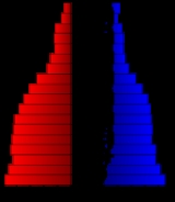
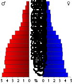
Demographics
United States Census, 2000
The Twenty-second United States Census, known as Census 2000 and conducted by the Census Bureau, determined the resident population of the United States on April 1, 2000, to be 281,421,906, an increase of 13.2% over the 248,709,873 persons enumerated during the 1990 Census...
, there were 32,458 people, 10,852 households, and 7,856 families residing in the county. The population density
Population density
Population density is a measurement of population per unit area or unit volume. It is frequently applied to living organisms, and particularly to humans...
was 30 people per square mile (11/km²). There were 11,650 housing units at an average density of 11 per square mile (4/km²). The racial makeup
Race (United States Census)
Race and ethnicity in the United States Census, as defined by the Federal Office of Management and Budget and the United States Census Bureau, are self-identification data items in which residents choose the race or races with which they most closely identify, and indicate whether or not they are...
of the county was 74.85% White
White American
White Americans are people of the United States who are considered or consider themselves White. The United States Census Bureau defines White people as those "having origins in any of the original peoples of Europe, the Middle East, or North Africa...
, 1.62% Black or African American
African American
African Americans are citizens or residents of the United States who have at least partial ancestry from any of the native populations of Sub-Saharan Africa and are the direct descendants of enslaved Africans within the boundaries of the present United States...
, 0.63% Native American
Native Americans in the United States
Native Americans in the United States are the indigenous peoples in North America within the boundaries of the present-day continental United States, parts of Alaska, and the island state of Hawaii. They are composed of numerous, distinct tribes, states, and ethnic groups, many of which survive as...
, 2.05% Asian
Asian American
Asian Americans are Americans of Asian descent. The U.S. Census Bureau definition of Asians as "Asian” refers to a person having origins in any of the original peoples of the Far East, Southeast Asia, or the Indian subcontinent, including, for example, Cambodia, China, India, Indonesia, Japan,...
, 0.12% Pacific Islander
Pacific Islander American
Pacific Islander Americans, also known as Oceanian Americans, are residents of the United States with original ancestry from Oceania. They represent the smallest racial group counted in the United States census of 2000. They numbered 874,000 people or 0.3 percent of the United States population...
, 18.17% from other races, and 2.56% from two or more races
Multiracial
The terms multiracial and mixed-race describe people whose ancestries come from multiple races. Unlike the term biracial, which often is only used to refer to having parents or grandparents of two different races, the term multiracial may encompass biracial people but can also include people with...
. Hispanic
Hispanic
Hispanic is a term that originally denoted a relationship to Hispania, which is to say the Iberian Peninsula: Andorra, Gibraltar, Portugal and Spain. During the Modern Era, Hispanic sometimes takes on a more limited meaning, particularly in the United States, where the term means a person of ...
or Latino
Latino
The demonyms Latino and Latina , are defined in English language dictionaries as:* "a person of Latin-American descent."* "A Latin American."* "A person of Hispanic, especially Latin-American, descent, often one living in the United States."...
of any race were 37.68% of the population.
There were 10,852 household
Household
The household is "the basic residential unit in which economic production, consumption, inheritance, child rearing, and shelter are organized and carried out"; [the household] "may or may not be synonymous with family"....
s out of which 40.90% had children under the age of 18 living with them, 57.90% were married couples
Marriage
Marriage is a social union or legal contract between people that creates kinship. It is an institution in which interpersonal relationships, usually intimate and sexual, are acknowledged in a variety of ways, depending on the culture or subculture in which it is found...
living together, 9.20% had a female householder with no husband present, and 27.60% were non-families. 22.70% of all households were made up of individuals and 9.50% had someone living alone who was 65 years of age or older. The average household size was 2.92 and the average family size was 3.42.
In the county the population was spread out with 31.10% under the age of 18, 11.20% from 18 to 24, 29.40% from 25 to 44, 17.30% from 45 to 64, and 11.00% who were 65 years of age or older. The median age was 30 years. For every 100 females there were 107.20 males. For every 100 females age 18 and over, there were 105.30 males.
The median income for a household
Median household income
The median household income is commonly used to generate data about geographic areas and divides households into two equal segments with the first half of households earning less than the median household income and the other half earning more...
in the county was $37,860, and the median income for a family was $42,734. Males had a median income of $27,189 versus $22,165 for females. The per capita income
Per capita income
Per capita income or income per person is a measure of mean income within an economic aggregate, such as a country or city. It is calculated by taking a measure of all sources of income in the aggregate and dividing it by the total population...
for the county was $15,721. About 9.90% of families and 12.40% of the population were below the poverty line, including 15.40% of those under age 18 and 8.40% of those age 65 or over.
Incorporated cities
Name and population (2004 estimate):- Dodge CityDodge City, KansasDodge City is a city in, and the county seat of, Ford County, Kansas, United States. Named after nearby Fort Dodge, the city is famous in American culture for its history as a wild frontier town of the Old West. As of the 2010 census, the city population was 27,340.-History:The first settlement of...
, 25,762 (county seat) - SpearvilleSpearville, KansasSpearville is a city in Ford County, Kansas, United States. As of the 2010 census, the city population was 773.-19th century:The land for the townsite of Speareville was deeded by the Santa Fe to the Arkansas Valley Town Company in March, 1873, and was surveyed and platted. The town was named for...
, 845 - BucklinBucklin, KansasBucklin is a city in Ford County, Kansas, United States. As of the 2010 census, the city population was 794.-Geography:Bucklin is located at . According to the United States Census Bureau, the city has a total area of , all of it land.-Demographics:As of the census of 2000, there were 725 people,...
, 722 - FordFord, KansasFord is a city in Ford County, Kansas, United States. As of the 2010 census, the city population was 216.-Geography:Ford is located at . According to the United States Census Bureau, the city has a total area of , all of it land....
, 325
Unincorporated places
- Bellefont
- BloomBloom, KansasBloom is a small unincorporated community in Ford County, Kansas, United States. The post office closed in 1992.-History:Bloom was established in 1888. The small town sprang to life as the Rock Island Railroad pushed west. The original train depot is still located in Bloom. Bloom reached a...
- Ft. Dodge
- Howell
- Kingsdown
- Wilroads
- Wilroads Gardens
- WindthorstWindthorst, KansasWindthorst is an unincorporated community in Ford County, Kansas, United States.The present-day community consists of a church, a school, a priest's house, and residential housing, but little more. It has no railroad station or post office. The closest town is Spearville. The community is best...
- Wright
Townships
Ford County is divided into fourteen townshipsCivil township
A civil township is a widely used unit of local government in the United States, subordinate to, and geographic divisions of, a county. Specific responsibilities and the degree of autonomy vary based on each state. Civil townships are distinct from survey townships, but in states that have both,...
. The city of Dodge City
Dodge City, Kansas
Dodge City is a city in, and the county seat of, Ford County, Kansas, United States. Named after nearby Fort Dodge, the city is famous in American culture for its history as a wild frontier town of the Old West. As of the 2010 census, the city population was 27,340.-History:The first settlement of...
is considered governmentally independent and is excluded from the census figures for the townships. In the following table, the population center is the largest city (or cities) included in that township's population total, if it is of a significant size.
| Township | FIPS | Population center |
Population | Population density /km² (/sq mi) |
Land area km² (sq mi) | Water area km² (sq mi) | Water % | Geographic coordinates |
|---|---|---|---|---|---|---|---|---|
| Bloom | 07375 | 113 | 1 (2) | 144 (55) | 0 (0) | 0 % | 37°30′23"N 99°55′4"W | |
| Bucklin | 09025 | 900 | 3 (8) | 285 (110) | 0 (0) | 0.02% | 37°34′44"N 99°37′9"W | |
| Concord | 15150 | 117 | 1 (2) | 187 (72) | 0 (0) | 0.11% | 37°36′36"N 100°5′52"W | |
| Dodge | 18225 | 899 | 13 (33) | 70 (27) | 0 (0) | 0.21% | 37°47′0"N 100°0′52"W | |
| Enterprise | 21450 | 1,113 | 6 (17) | 175 (67) | 0 (0) | 0.19% | 37°40′47"N 99°57′8"W | |
| Fairview | 22500 | 346 | 2 (5) | 188 (73) | 0 (0) | 0.06% | 37°45′11"N 100°8′57"W | |
| Ford | 23750 | 456 | 2 (5) | 249 (96) | 0 (0) | 0.01% | 37°36′58"N 99°46′27"W | |
| Grandview | 27350 | 784 | 3 (9) | 226 (87) | 0 (0) | 0.20% | 37°47′10"N 99°55′54"W | |
| Richland | 59300 | 931 | 9 (24) | 99 (38) | 0 (0) | 0.17% | 37°42′10"N 100°2′19"W | |
| Royal | 61575 | 105 | 1 (1) | 185 (72) | 0 (0) | 0.06% | 37°51′51"N 100°6′44"W | |
| Sodville | 66150 | 110 | 1 (2) | 145 (56) | 0 (0) | 0.01% | 37°31′16"N 99°45′6"W | |
| Spearville | 67150 | 1,150 | 2 (6) | 479 (185) | 0 (0) | 0.03% | 37°47′58"N 99°45′4"W | |
| Wheatland | 77675 | 170 | 1 (2) | 193 (74) | 0 (0) | 0 % | 37°48′58"N 99°37′22"W | |
| Wilburn | 79100 | 88 | 0 (1) | 187 (72) | 0 (0) | 0 % | 37°31′22"N 100°7′10"W | |
| Sources: | ||||||||
Unified school districts
See also
- National Register of Historic Places listings in Ford County, KansasNational Register of Historic Places listings in Ford County, KansasThis is a list of the National Register of Historic Places listings in Ford County, Kansas.This is intended to be a complete list of the properties on the National Register of Historic Places in Ford County, Kansas, United States...
Further reading
- History of the State of Kansas; William G. Cutler; A.T. Andreas Publisher; 1883. (Online HTML eBook)
- Kansas : A Cyclopedia of State History, Embracing Events, Institutions, Industries, Counties, Cities, Towns, Prominent Persons, Etc; 3 Volumes; Frank W. Blackmar; Standard Publishing Co; 944 / 955 / 824 pages; 1912. (Volume1 - Download 54MB PDF eBook), (Volume2 - Download 53MB PDF eBook), (Volume3 - Download 33MB PDF eBook)
External links
Official sitesAdditional information
History and Genealogy
- Ford County History from FCHS, Dodge City, KS
- Ford County GenWeb
- Ford County from American History and Genealogy Project (AHGP)
Maps
- Ford County Map, KDOT
- Kansas Highway Map, KDOT
- Kansas Railroad Map, KDOT
- Kansas School District Boundary Map, KSDE