
Republic County, Kansas
Encyclopedia
Republic County is a county located in the state
of Kansas
. As of the 2010 census, the county population was 4,980. The largest city and county seat
is Belleville
.
During the late 19th century, Belleville became the urban center for the immigrants that were attracted to the surrounding areas, most notably from Sweden
and Bohemia
(now Czech Republic
).
In 1887, Atchison, Topeka and Santa Fe Railway
built a branch line from Neva (3 miles west of Strong City
) to Superior, Nebraska
. This branch line connected Strong City
, Neva, Rockland, Diamond Springs, Burdick
, Lost Springs
, Jacobs, Hope
, Navarre
, Enterprise
, Abilene
, Talmage
, Manchester
, Longford
, Oak Hill
, Miltonvale
, Aurora
, Huscher
, Concordia
, Kackley
, Courtland
, Webber
, Superior
. At some point, the line from Neva to Lost Springs
was pulled but the right of way has not been abandoned. This branch line was originally called "Strong City and Superior line" but later the name was shortened to the "Strong City line". In 1996, the Atchison, Topeka and Santa Fe Railway
merged with Burlington Northern Railroad
and renamed to the current BNSF Railway
. Most locals still refer to this railroad as the "Santa Fe".
, county until the Kansas Constitution was amended in 1986 and voters approved the sale of alcoholic liquor by the individual drink with a 30% food sales requirement.
 As of the census
of 2000, there were 5,835 people, 2,557 households, and 1,685 families residing in the county. The population density
was 8 people per square mile (3/km²). There were 3,113 housing units at an average density of 4 per square mile (2/km²). The racial makeup of the county was 98.56% White
, 0.26% Black
or African American
, 0.21% Native American
, 0.19% Asian
, 0.33% from other races
, and 0.46% from two or more races. 0.94% of the population were Hispanic
or Latino
of any race. 24.1% were of German
, 13.6% Swedish, 12.4% Czech, 9.2% English
, 9.0% Irish
and 8.6% American
ancestry according to Census 2000.
There were 2,557 households out of which 25.60% had children under the age of 18 living with them, 58.80% were married couples
living together, 4.80% had a female householder with no husband present, and 34.10% were non-families. 31.80% of all households were made up of individuals and 18.00% had someone living alone who was 65 years of age or older. The average household size was 2.23 and the average family size was 2.80.
In the county the population was spread out with 22.30% under the age of 18, 4.50% from 18 to 24, 22.10% from 25 to 44, 25.00% from 45 to 64, and 26.10% who were 65 years of age or older. The median age was 46 years. For every 100 females there were 93.20 males. For every 100 females age 18 and over, there were 90.80 males.
The median income for a household in the county was $30,494, and the median income for a family was $39,215. Males had a median income of $25,260 versus $17,274 for females. The per capita income
for the county was $17,433. About 6.00% of families and 9.10% of the population were below the poverty line, including 12.40% of those under age 18 and 8.90% of those age 65 or over.
. The city of Belleville
is considered governmentally independent and is excluded from the census figures for the townships. In the following table, the population center is the largest city (or cities) included in that township's population total, if it is of a significant size.
Historical
Maps
U.S. state
A U.S. state is any one of the 50 federated states of the United States of America that share sovereignty with the federal government. Because of this shared sovereignty, an American is a citizen both of the federal entity and of his or her state of domicile. Four states use the official title of...
of Kansas
Kansas
Kansas is a US state located in the Midwestern United States. It is named after the Kansas River which flows through it, which in turn was named after the Kansa Native American tribe, which inhabited the area. The tribe's name is often said to mean "people of the wind" or "people of the south...
. As of the 2010 census, the county population was 4,980. The largest city and county seat
County seat
A county seat is an administrative center, or seat of government, for a county or civil parish. The term is primarily used in the United States....
is Belleville
Belleville, Kansas
Belleville is a city in and the county seat of Republic County, Kansas, United States. As of the 2010 census, the city population was 1,991.-Geography:Belleville is located at...
.
19th century
Republic County was first settled around 1860 by Daniel and Conrad Myers. The territory was principally inhabited by Pawnees, Iowas, and Otoes who greeted the incoming settlers - mostly farmers - peaceably. By 1868, Republic County was holding elections.During the late 19th century, Belleville became the urban center for the immigrants that were attracted to the surrounding areas, most notably from Sweden
Sweden
Sweden , officially the Kingdom of Sweden , is a Nordic country on the Scandinavian Peninsula in Northern Europe. Sweden borders with Norway and Finland and is connected to Denmark by a bridge-tunnel across the Öresund....
and Bohemia
Bohemia
Bohemia is a historical region in central Europe, occupying the western two-thirds of the traditional Czech Lands. It is located in the contemporary Czech Republic with its capital in Prague...
(now Czech Republic
Czech Republic
The Czech Republic is a landlocked country in Central Europe. The country is bordered by Poland to the northeast, Slovakia to the east, Austria to the south, and Germany to the west and northwest....
).
In 1887, Atchison, Topeka and Santa Fe Railway
Atchison, Topeka and Santa Fe Railway
The Atchison, Topeka and Santa Fe Railway , often abbreviated as Santa Fe, was one of the larger railroads in the United States. The company was first chartered in February 1859...
built a branch line from Neva (3 miles west of Strong City
Strong City, Kansas
Strong City is a city in Chase County, Kansas, United States. It is named after William Barstow Strong, former president of the Atchison, Topeka and Santa Fe Railway. As of the 2010 census, the city population was 485.-19th century:...
) to Superior, Nebraska
Superior, Nebraska
Superior is a city in Nuckolls County, Nebraska, United States. As of the 2010 census, the city population was 1,957.Superior bills itself as the "Victorian Capital of Nebraska", and holds an annual Victorian Festival...
. This branch line connected Strong City
Strong City, Kansas
Strong City is a city in Chase County, Kansas, United States. It is named after William Barstow Strong, former president of the Atchison, Topeka and Santa Fe Railway. As of the 2010 census, the city population was 485.-19th century:...
, Neva, Rockland, Diamond Springs, Burdick
Burdick, Kansas
Burdick is an unincorporated community in southwestern Morris County, Kansas, United States. It lies along local roads south-southwest of the city of Council Grove, the county seat of Morris County. Its elevation is 1,453 feet , and it is located at...
, Lost Springs
Lost Springs, Kansas
Lost Springs is a city in Marion County, Kansas, United States. It was named for the old lost spring near the city. As of the 2010 census, the city population was 70.-19th century:...
, Jacobs, Hope
Hope, Kansas
Hope is a city in southern Dickinson County, Kansas, United States. As of the 2010 census, the city population was 368. The motto of Hope is "There Will Always Be Hope In Kansas", which is also the name of a song.-History:...
, Navarre
Navarre, Kansas
Navarre is a small unincorporated community in Dickinson County, Kansas, United States. The post office was established February 7, 1884, and discontinued September 3, 1971.-History:...
, Enterprise
Enterprise, Kansas
Enterprise is a city in Dickinson County, Kansas, United States. As of the 2010 census, the city population was 855.-History:On January 10, 1883, the Enterprise Town Company, capital $50,000, was organized. The following officers were elected: V. P. Wilson, president; John Johntz, vice-president;...
, Abilene
Abilene, Kansas
Abilene is a city in and the county seat of Dickinson County, Kansas, United States. As of the 2010 census, the city population was 6,844.-History:...
, Talmage
Talmage, Kansas
Talmage is a small unincorporated community in Dickinson County, Kansas, United States. The post office was established December 22, 1887.-History:...
, Manchester
Manchester, Kansas
Manchester is a city in Dickinson County, Kansas, United States. As of the 2010 census, the city population was 95.-History:In 1887, Atchison, Topeka and Santa Fe Railway built a branch line from Neva through Manchester to Superior, Nebraska...
, Longford
Longford, Kansas
Longford is a city in Clay County, Kansas, United States. As of the 2010 census, the city population was 79.-History:In 1887, Atchison, Topeka and Santa Fe Railway built a branch line from Neva through Longford to Superior, Nebraska...
, Oak Hill
Oak Hill, Kansas
Oak Hill is a city in Clay County, Kansas, United States. As of the 2010 census, the city population was 24.-History:In 1887, Atchison, Topeka and Santa Fe Railway built a branch line from Neva through Oak Hill to Superior, Nebraska...
, Miltonvale
Miltonvale, Kansas
Miltonvale is a city in Cloud County, Kansas, United States. As of the 2010 census, the city population was 539.-History:Miltonvale was founded on December 1, 1881.From 1909 to 1972, it was the home of Miltonvale Wesleyan College....
, Aurora
Aurora, Kansas
Aurora is a city in Cloud County, Kansas, United States. As of the 2010 census, the city population was 60.-History:In 1887, Atchison, Topeka and Santa Fe Railway built a branch line from Neva through Aurora to Superior, Nebraska...
, Huscher
Huscher, Kansas
Huscher is an unincorporated rural area in Cloud County, Kansas, United States.-History:In 1887, Atchison, Topeka and Santa Fe Railway built a branch line from Neva through Huscher to Superior, Nebraska. In 1996, the Atchison, Topeka and Santa Fe Railway merged with Burlington Northern Railroad...
, Concordia
Concordia, Kansas
Concordia is a city in and the county seat of Cloud County, Kansas, United States. Located on the Republican River in the Smoky Hills region of the Great Plains, Concordia was founded in 1871 and is an economic and cultural center in north-central Kansas...
, Kackley
Kackley, Kansas
Kackley is an unincorporated rural area in Republic County, Kansas, United States.-History:In 1887, Atchison, Topeka and Santa Fe Railway built a branch line from Neva through Kackley to Superior, Nebraska. In 1996, the Atchison, Topeka and Santa Fe Railway merged with Burlington Northern...
, Courtland
Courtland, Kansas
Courtland is a city in Republic County, Kansas, United States. As of the 2010 census, the city population was 285.-History:In 1887, Atchison, Topeka and Santa Fe Railway built a branch line from Neva through Courtland to Superior, Nebraska...
, Webber
Webber, Kansas
Webber is a city in Jewell County, Kansas, United States. As of the 2010 census, the city population was 25.-History:In 1887, Atchison, Topeka and Santa Fe Railway built a branch line from Neva through Webber to Superior, Nebraska...
, Superior
Superior, Nebraska
Superior is a city in Nuckolls County, Nebraska, United States. As of the 2010 census, the city population was 1,957.Superior bills itself as the "Victorian Capital of Nebraska", and holds an annual Victorian Festival...
. At some point, the line from Neva to Lost Springs
Lost Springs, Kansas
Lost Springs is a city in Marion County, Kansas, United States. It was named for the old lost spring near the city. As of the 2010 census, the city population was 70.-19th century:...
was pulled but the right of way has not been abandoned. This branch line was originally called "Strong City and Superior line" but later the name was shortened to the "Strong City line". In 1996, the Atchison, Topeka and Santa Fe Railway
Atchison, Topeka and Santa Fe Railway
The Atchison, Topeka and Santa Fe Railway , often abbreviated as Santa Fe, was one of the larger railroads in the United States. The company was first chartered in February 1859...
merged with Burlington Northern Railroad
Burlington Northern Railroad
The Burlington Northern Railroad was a United States-based railroad company formed from a merger of four major U.S. railroads. Burlington Northern operated between 1970 and 1996....
and renamed to the current BNSF Railway
BNSF Railway
The BNSF Railway is a wholly owned subsidiary of Berkshire Hathaway Inc., and is headquartered in Fort Worth, Texas. It is one of seven North American Class I railroads and the second largest freight railroad network in North America, second only to the Union Pacific Railroad, its primary...
. Most locals still refer to this railroad as the "Santa Fe".
Law and government
Republic County was a prohibition, or "dry"Dry county
A dry county is a county in the United States whose government forbids the sale of alcoholic beverages. Some prohibit off-premises sale, some prohibit on-premises sale, and some prohibit both. Hundreds of dry counties exist across the United States, almost all of them in the South...
, county until the Kansas Constitution was amended in 1986 and voters approved the sale of alcoholic liquor by the individual drink with a 30% food sales requirement.
Geography
According to the 2000 census, the county has a total area of 720.31 square miles (1,865.6 km²), of which 716.38 square miles (1,855.4 km²) (or 99.45%) is land and 3.93 square miles (10.2 km²) (or 0.55%) is water.Adjacent counties
- Thayer CountyThayer County, Nebraska-History:Thayer County was formed in 1872. It was named after the General and Governor John Milton Thayer.-Demographics:As of the census of 2000, there were 6,055 people, 2,541 households, and 1,689 families residing in the county. The population density was 10 people per square mile . There were...
, NebraskaNebraskaNebraska is a state on the Great Plains of the Midwestern United States. The state's capital is Lincoln and its largest city is Omaha, on the Missouri River....
(north) - Jefferson CountyJefferson County, Nebraska-Demographics:As of the census of 2000, there were 8,333 people, 3,527 households, and 2,352 families residing in the county. The population density was 14 people per square mile . There were 3,942 housing units at an average density of 7 per square mile...
, NebraskaNebraskaNebraska is a state on the Great Plains of the Midwestern United States. The state's capital is Lincoln and its largest city is Omaha, on the Missouri River....
(northeast) - Washington CountyWashington County, KansasWashington County is a county located in the U.S. state of Kansas. As of the 2010 census, the county population was 5,799...
(east) - Cloud CountyCloud County, KansasCloud County is a county located in North Central Kansas, in the Central United States. As of the 2010 census, the county population was 9,533. Its county seat and most populous city is Concordia.-19th century:...
(south) - Jewell CountyJewell County, KansasJewell County is a county located in North Central Kansas, in the Central United States. As of the 2010 census, the county population was 3,077. Its county seat and most populous city is Mankato.-19th century:...
(west) - Nuckolls CountyNuckolls County, NebraskaNuckolls County is a county located in the U.S. state of Nebraska. As of the 2010 census, the county population was 4,500. Its county seat is Nelson....
, NebraskaNebraskaNebraska is a state on the Great Plains of the Midwestern United States. The state's capital is Lincoln and its largest city is Omaha, on the Missouri River....
(northwest)
Demographics
Census
A census is the procedure of systematically acquiring and recording information about the members of a given population. It is a regularly occurring and official count of a particular population. The term is used mostly in connection with national population and housing censuses; other common...
of 2000, there were 5,835 people, 2,557 households, and 1,685 families residing in the county. The population density
Population density
Population density is a measurement of population per unit area or unit volume. It is frequently applied to living organisms, and particularly to humans...
was 8 people per square mile (3/km²). There were 3,113 housing units at an average density of 4 per square mile (2/km²). The racial makeup of the county was 98.56% White
Race (United States Census)
Race and ethnicity in the United States Census, as defined by the Federal Office of Management and Budget and the United States Census Bureau, are self-identification data items in which residents choose the race or races with which they most closely identify, and indicate whether or not they are...
, 0.26% Black
Race (United States Census)
Race and ethnicity in the United States Census, as defined by the Federal Office of Management and Budget and the United States Census Bureau, are self-identification data items in which residents choose the race or races with which they most closely identify, and indicate whether or not they are...
or African American
Race (United States Census)
Race and ethnicity in the United States Census, as defined by the Federal Office of Management and Budget and the United States Census Bureau, are self-identification data items in which residents choose the race or races with which they most closely identify, and indicate whether or not they are...
, 0.21% Native American
Race (United States Census)
Race and ethnicity in the United States Census, as defined by the Federal Office of Management and Budget and the United States Census Bureau, are self-identification data items in which residents choose the race or races with which they most closely identify, and indicate whether or not they are...
, 0.19% Asian
Race (United States Census)
Race and ethnicity in the United States Census, as defined by the Federal Office of Management and Budget and the United States Census Bureau, are self-identification data items in which residents choose the race or races with which they most closely identify, and indicate whether or not they are...
, 0.33% from other races
Race (United States Census)
Race and ethnicity in the United States Census, as defined by the Federal Office of Management and Budget and the United States Census Bureau, are self-identification data items in which residents choose the race or races with which they most closely identify, and indicate whether or not they are...
, and 0.46% from two or more races. 0.94% of the population were Hispanic
Race (United States Census)
Race and ethnicity in the United States Census, as defined by the Federal Office of Management and Budget and the United States Census Bureau, are self-identification data items in which residents choose the race or races with which they most closely identify, and indicate whether or not they are...
or Latino
Race (United States Census)
Race and ethnicity in the United States Census, as defined by the Federal Office of Management and Budget and the United States Census Bureau, are self-identification data items in which residents choose the race or races with which they most closely identify, and indicate whether or not they are...
of any race. 24.1% were of German
Germans
The Germans are a Germanic ethnic group native to Central Europe. The English term Germans has referred to the German-speaking population of the Holy Roman Empire since the Late Middle Ages....
, 13.6% Swedish, 12.4% Czech, 9.2% English
English people
The English are a nation and ethnic group native to England, who speak English. The English identity is of early mediaeval origin, when they were known in Old English as the Anglecynn. England is now a country of the United Kingdom, and the majority of English people in England are British Citizens...
, 9.0% Irish
Irish people
The Irish people are an ethnic group who originate in Ireland, an island in northwestern Europe. Ireland has been populated for around 9,000 years , with the Irish people's earliest ancestors recorded having legends of being descended from groups such as the Nemedians, Fomorians, Fir Bolg, Tuatha...
and 8.6% American
United States
The United States of America is a federal constitutional republic comprising fifty states and a federal district...
ancestry according to Census 2000.
There were 2,557 households out of which 25.60% had children under the age of 18 living with them, 58.80% were married couples
Marriage
Marriage is a social union or legal contract between people that creates kinship. It is an institution in which interpersonal relationships, usually intimate and sexual, are acknowledged in a variety of ways, depending on the culture or subculture in which it is found...
living together, 4.80% had a female householder with no husband present, and 34.10% were non-families. 31.80% of all households were made up of individuals and 18.00% had someone living alone who was 65 years of age or older. The average household size was 2.23 and the average family size was 2.80.
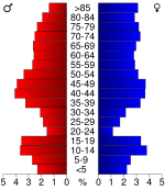
In the county the population was spread out with 22.30% under the age of 18, 4.50% from 18 to 24, 22.10% from 25 to 44, 25.00% from 45 to 64, and 26.10% who were 65 years of age or older. The median age was 46 years. For every 100 females there were 93.20 males. For every 100 females age 18 and over, there were 90.80 males.
The median income for a household in the county was $30,494, and the median income for a family was $39,215. Males had a median income of $25,260 versus $17,274 for females. The per capita income
Per capita income
Per capita income or income per person is a measure of mean income within an economic aggregate, such as a country or city. It is calculated by taking a measure of all sources of income in the aggregate and dividing it by the total population...
for the county was $17,433. About 6.00% of families and 9.10% of the population were below the poverty line, including 12.40% of those under age 18 and 8.90% of those age 65 or over.
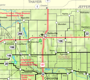
Incorporated cities
Name and population (2004 estimate):- BellevilleBelleville, KansasBelleville is a city in and the county seat of Republic County, Kansas, United States. As of the 2010 census, the city population was 1,991.-Geography:Belleville is located at...
, 1,984 (county seat) - ScandiaScandia, KansasScandia is a city in Republic County, Kansas, United States. As of the 2010 census, the city population was 372.-History:The first American flag to be flown in what is now Kansas was raised near Scandia in 1806. It wasn't settled until 1868 by Swedes fleeing a famine in their native country, and...
, 380 - CourtlandCourtland, KansasCourtland is a city in Republic County, Kansas, United States. As of the 2010 census, the city population was 285.-History:In 1887, Atchison, Topeka and Santa Fe Railway built a branch line from Neva through Courtland to Superior, Nebraska...
, 295 - CubaCuba, KansasCuba is a city in Republic County, Kansas, United States. As of the 2010 census, the city population was 156.-History:The city of Cuba, Kansas was founded in 1868 by American southerners traveling westward after the American Civil War. The city received its name from one settler who had once lived...
, 210 - RepublicRepublic, KansasRepublic is a city in Republic County, Kansas, United States. As of the 2010 census, the city population was 116.-Geography:Republic is located at . According to the United States Census Bureau, the city has a total area of , all of it land.-Demographics:As of the census of 2000, there were 161...
, 146 - MundenMunden, KansasMunden is a city in Republic County, Kansas, United States. As of the 2010 census, the city population was 100.-Geography:Munden is located at . According to the United States Census Bureau, the city has a total area of , all of it land.-Demographics:As of the census of 2000, there were 122...
, 111 - NarkaNarka, KansasNarka is a city in Republic County, Kansas, United States. As of the 2010 census, the city population was 94.-Geography:Narka is located at . According to the United States Census Bureau, the city has a total area of , all of it land.-Demographics:As of the census of 2000, there were 93 people,...
, 84 - AgendaAgenda, KansasAgenda is a city in Republic County, Kansas, United States. As of the 2010 census, the city population was 68.-Geography:Agenda is located at . According to the United States Census Bureau, the city has a total area of , all of it land.-Demographics:As of the census of 2000, there were 81...
, 73
Unincorporated cities
- KackleyKackley, KansasKackley is an unincorporated rural area in Republic County, Kansas, United States.-History:In 1887, Atchison, Topeka and Santa Fe Railway built a branch line from Neva through Kackley to Superior, Nebraska. In 1996, the Atchison, Topeka and Santa Fe Railway merged with Burlington Northern...
- NorwayNorway, KansasNorway is an unincorporated rural area in Republic County, Kansas, United States.-Resources:* Video story of Belva Morgan, the postmaster of Norway. Includes video of downtown buildings and surrounding area.* of a tour including Norway...
- Talmo
- WayneWayne, KansasWayne is an unincorporated rural area in Republic County, Kansas, United States....
Townships
Republic County is divided into twenty townshipsCivil township
A civil township is a widely used unit of local government in the United States, subordinate to, and geographic divisions of, a county. Specific responsibilities and the degree of autonomy vary based on each state. Civil townships are distinct from survey townships, but in states that have both,...
. The city of Belleville
Belleville, Kansas
Belleville is a city in and the county seat of Republic County, Kansas, United States. As of the 2010 census, the city population was 1,991.-Geography:Belleville is located at...
is considered governmentally independent and is excluded from the census figures for the townships. In the following table, the population center is the largest city (or cities) included in that township's population total, if it is of a significant size.
| Township | FIPS | Population center |
Population | Population density /km² (/sq mi) |
Land area km² (sq mi) | Water area km² (sq mi) | Water % | Geographic coordinates |
|---|---|---|---|---|---|---|---|---|
| Albion | 00900 | 174 | 2 (5) | 92 (36) | 0 (0) | 0.12% | 39°57′35"N 97°25′29"W | |
| Beaver | 05150 | 137 | 2 (4) | 91 (35) | 3 (1) | 3.04% | 39°42′17"N 97°51′59"W | |
| Belleville | 05625 | 231 | 3 (7) | 89 (34) | 0 (0) | 0.11% | 39°47′14"N 97°38′35"W | |
| Big Bend | 06550 | 242 | 3 (7) | 92 (35) | 1 (0) | 1.39% | 39°57′0"N 97°50′53"W | |
| Courtland | 16050 | 450 | 5 (12) | 94 (36) | 0 (0) | 0.06% | 39°46′56"N 97°52′51"W | |
| Elk Creek | 20275 | 175 | 2 (5) | 94 (36) | 0 (0) | 0.15% | 39°42′16"N 97°25′41"W | |
| Fairview | 22575 | 155 | 2 (4) | 94 (36) | 0 (0) | 0.49% | 39°52′50"N 97°31′54"W | |
| Farmington | 23200 | 81 | 1 (2) | 93 (36) | 0 (0) | 0.20% | 39°52′20"N 97°25′24"W | |
| Freedom | 24675 | 186 | 2 (5) | 90 (35) | 0 (0) | 0.28% | 39°51′31"N 97°38′26"W | |
| Grant | 28050 | 77 | 1 (2) | 95 (37) | 0 (0) | 0.15% | 39°42′5"N 97°32′31"W | |
| Jefferson | 35325 | 107 | 1 (3) | 95 (37) | 0 (0) | 0.05% | 39°47′29"N 97°32′33"W | |
| Liberty | 40325 | 52 | 1 (1) | 93 (36) | 0 (0) | 0.19% | 39°57′2"N 97°38′30"W | |
| Lincoln | 41075 | 103 | 1 (3) | 92 (36) | 0 (0) | 0.09% | 39°41′58"N 97°38′57"W | |
| Norway | 51575 | 163 | 2 (5) | 92 (36) | 1 (0) | 1.19% | 39°42′17"N 97°46′9"W | |
| Richland | 59575 | 318 | 3 (9) | 92 (36) | 0 (0) | 0.11% | 39°47′30"N 97°26′4"W | |
| Rose Creek | 61200 | 170 | 2 (5) | 94 (36) | 0 (0) | 0.44% | 39°57′27"N 97°32′13"W | |
| Scandia | 63375 | 541 | 6 (15) | 92 (36) | 1 (0) | 1.23% | 39°47′28"N 97°46′27"W | |
| Union | 72300 | 51 | 1 (1) | 93 (36) | 0 (0) | 0.18% | 39°52′0"N 97°46′5"W | |
| Washington | 75700 | 95 | 1 (3) | 93 (36) | 0 (0) | 0.24% | 39°57′57"N 97°45′14"W | |
| White Rock | 77975 | 88 | 1 (2) | 92 (36) | 1 (0) | 1.09% | 39°52′34"N 97°51′54"W |
Unified school districts
See also
- National Register of Historic Places listings in Republic County, KansasNational Register of Historic Places listings in Republic County, KansasThis is a list of the National Register of Historic Places listings in Republic County, Kansas.This is intended to be a complete list of the properties and districts on the National Register of Historic Places in Republic County, Kansas, United States...
Further reading
- History of the State of Kansas; William G. Cutler; A.T. Andreas Publisher; 1883. (Online HTML eBook)
- Kansas : A Cyclopedia of State History, Embracing Events, Institutions, Industries, Counties, Cities, Towns, Prominent Persons, Etc; 3 Volumes; Frank W. Blackmar; Standard Publishing Co; 944 / 955 / 824 pages; 1912. (Volume1 - Download 54MB PDF eBook),(Volume2 - Download 53MB PDF eBook), (Volume3 - Download 33MB PDF eBook)
External links
County- Republic County - Official Website
- Republic County - Directory of Public Officials
- Republic County - Information, Skyways
Historical
- Cutler's History of Republic County, Kansas
- Republic County GenWeb
- Republic County Historical Society Museum
Maps
- Republic County Map, KDOT
- Kansas Highway Map, KDOT
- Kansas Railroad Map, KDOT
- Kansas School District Boundary Map, KSDE