

Kiowa County, Kansas
Encyclopedia
Kiowa County is a county located in the U.S. state
of Kansas
. As of the 2010 census, the county population was 2,553. The largest city and county seat
is Greensburg
.
The county should not be confused with the city of Kiowa
, which is located in Barber County
.
was devastated by an EF5 tornado
on May 4, 2007 during the May 2007 tornado outbreak
.
, county.
Kiowa County has a large number of iron-rich meteorite
s in its soil due to the Brenham meteor fall over 10 thousand years ago.
 As of the census
of 2000, there were 3,278 people, 1,365 households, and 924 families residing in the county. The population density
was 4 people per square mile (2/km²). There were 1,643 housing units at an average density of 2 per square mile (1/km²). The racial makeup of the county was 97.19% White
, 0.21% Black
or African American
, 0.61% Native American
, 0.27% Asian
, 0.98% from other races
, and 0.73% from two or more races. 2.04% of the population were Hispanic
or Latino
of any race.
There were 1,365 households out of which 27.70% had children under the age of 18 living with them, 59.60% were married couples
living together, 5.30% had a female householder with no husband present, and 32.30% were non-families. 30.50% of all households were made up of individuals and 15.50% had someone living alone who was 65 years of age or older. The average household size was 2.32 and the average family size was 2.89.
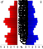
In the county the population was spread out with 24.00% under the age of 18, 8.20% from 18 to 24, 21.80% from 25 to 44, 24.60% from 45 to 64, and 21.30% who were 65 years of age or older. The median age was 42 years. For every 100 females there were 96.30 males. For every 100 females age 18 and over, there were 95.10 males.
The median income for a household in the county was $31,576, and the median income for a family was $40,950. Males had a median income of $29,063 versus $20,764 for females. The per capita income
for the county was $17,207. About 7.40% of families and 10.80% of the population were below the poverty line, including 13.50% of those under age 18 and 8.70% of those age 65 or over.
, and none of the cities within the county are considered governmentally independent; all figures for the township include those of the cities.
General county information
County level data
Local history and genealogy
Maps
U.S. state
A U.S. state is any one of the 50 federated states of the United States of America that share sovereignty with the federal government. Because of this shared sovereignty, an American is a citizen both of the federal entity and of his or her state of domicile. Four states use the official title of...
of Kansas
Kansas
Kansas is a US state located in the Midwestern United States. It is named after the Kansas River which flows through it, which in turn was named after the Kansa Native American tribe, which inhabited the area. The tribe's name is often said to mean "people of the wind" or "people of the south...
. As of the 2010 census, the county population was 2,553. The largest city and county seat
County seat
A county seat is an administrative center, or seat of government, for a county or civil parish. The term is primarily used in the United States....
is Greensburg
Greensburg, Kansas
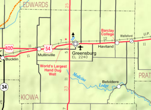
Greensburg is a city in and the county seat of Kiowa County, Kansas, United States. As of the 2010 census, the city population was 777. Greensburg is also home to the world's largest hand-dug well....
.
The county should not be confused with the city of Kiowa
Kiowa, Kansas
Kiowa is a city in Barber County, Kansas, United States. As of the 2010 census, the city population was 1,026.-19th century:Kiowas was the city where anti-saloon advocate Carrie Nation vandalized her first saloon.-Geography:...
, which is located in Barber County
Barber County, Kansas
Barber County is a county located in South Central Kansas, in the Central United States. As of the 2010 census, the county population was 4,861. Its county seat and most populous city is Medicine Lodge...
.
History
Greensburg, KansasGreensburg, Kansas
Greensburg is a city in and the county seat of Kiowa County, Kansas, United States. As of the 2010 census, the city population was 777. Greensburg is also home to the world's largest hand-dug well....
was devastated by an EF5 tornado
May 2007 Tornado Outbreak
The May 2007 Tornado Outbreak was an extended tornado outbreak that started on May 4, 2007, affecting portions of the Central United States. The most destructive tornado in the outbreak occurred on the evening of May 4 in western Kansas, where about 95% of the city of Greensburg in Kiowa County was...
on May 4, 2007 during the May 2007 tornado outbreak
May 2007 Tornado Outbreak
The May 2007 Tornado Outbreak was an extended tornado outbreak that started on May 4, 2007, affecting portions of the Central United States. The most destructive tornado in the outbreak occurred on the evening of May 4 in western Kansas, where about 95% of the city of Greensburg in Kiowa County was...
.
Law and government
Although the Kansas Constitution was amended in 1986 to allow the sale of alcoholic liquor by the individual drink with the approval of voters, Kiowa County has remained a prohibition, or "dry"Dry county
A dry county is a county in the United States whose government forbids the sale of alcoholic beverages. Some prohibit off-premises sale, some prohibit on-premises sale, and some prohibit both. Hundreds of dry counties exist across the United States, almost all of them in the South...
, county.
Geography
According to the 2000 census, the county has a total area of 722.62 square miles (1,871.6 km²), of which 722.39 square miles (1,871 km²) (or 99.97%) is land and 0.23 square mile (0.5956972653 km²) (or 0.03%) is water.Kiowa County has a large number of iron-rich meteorite
Meteorite
A meteorite is a natural object originating in outer space that survives impact with the Earth's surface. Meteorites can be big or small. Most meteorites derive from small astronomical objects called meteoroids, but they are also sometimes produced by impacts of asteroids...
s in its soil due to the Brenham meteor fall over 10 thousand years ago.
Adjacent counties
- Edwards CountyEdwards County, KansasEdwards County is a county located in Southwest Kansas, in the Central United States. As of the 2010 census, the county population was 3,037...
(north) - Pratt CountyPratt County, KansasPratt County is a county located in the U.S. state of Kansas. As of the 2010 census, the county population was 9,656. The largest city and county seat is Pratt.-19th century:...
(east) - Barber CountyBarber County, KansasBarber County is a county located in South Central Kansas, in the Central United States. As of the 2010 census, the county population was 4,861. Its county seat and most populous city is Medicine Lodge...
(southeast) - Comanche CountyComanche County, KansasComanche County is a county located in Southwest Kansas, in the Central United States. As of the 2010 census, the county population was 1,891...
(south) - Clark CountyClark County, KansasClark County is a county located in Southwest Kansas, in the Central United States. As of the 2010 census, the county population was 2,215...
(southwest) - Ford CountyFord County, KansasFord County is a county located in southwest Kansas, in the Central United States. As of the 2010 census, the county population was 33,848. The Dodge City Micropolitan Statistical Area includes all of Ford County. Its county seat and most populous city is Dodge City. The county is named in...
(west)
Demographics
Census
A census is the procedure of systematically acquiring and recording information about the members of a given population. It is a regularly occurring and official count of a particular population. The term is used mostly in connection with national population and housing censuses; other common...
of 2000, there were 3,278 people, 1,365 households, and 924 families residing in the county. The population density
Population density
Population density is a measurement of population per unit area or unit volume. It is frequently applied to living organisms, and particularly to humans...
was 4 people per square mile (2/km²). There were 1,643 housing units at an average density of 2 per square mile (1/km²). The racial makeup of the county was 97.19% White
Race (United States Census)
Race and ethnicity in the United States Census, as defined by the Federal Office of Management and Budget and the United States Census Bureau, are self-identification data items in which residents choose the race or races with which they most closely identify, and indicate whether or not they are...
, 0.21% Black
Race (United States Census)
Race and ethnicity in the United States Census, as defined by the Federal Office of Management and Budget and the United States Census Bureau, are self-identification data items in which residents choose the race or races with which they most closely identify, and indicate whether or not they are...
or African American
Race (United States Census)
Race and ethnicity in the United States Census, as defined by the Federal Office of Management and Budget and the United States Census Bureau, are self-identification data items in which residents choose the race or races with which they most closely identify, and indicate whether or not they are...
, 0.61% Native American
Race (United States Census)
Race and ethnicity in the United States Census, as defined by the Federal Office of Management and Budget and the United States Census Bureau, are self-identification data items in which residents choose the race or races with which they most closely identify, and indicate whether or not they are...
, 0.27% Asian
Race (United States Census)
Race and ethnicity in the United States Census, as defined by the Federal Office of Management and Budget and the United States Census Bureau, are self-identification data items in which residents choose the race or races with which they most closely identify, and indicate whether or not they are...
, 0.98% from other races
Race (United States Census)
Race and ethnicity in the United States Census, as defined by the Federal Office of Management and Budget and the United States Census Bureau, are self-identification data items in which residents choose the race or races with which they most closely identify, and indicate whether or not they are...
, and 0.73% from two or more races. 2.04% of the population were Hispanic
Race (United States Census)
Race and ethnicity in the United States Census, as defined by the Federal Office of Management and Budget and the United States Census Bureau, are self-identification data items in which residents choose the race or races with which they most closely identify, and indicate whether or not they are...
or Latino
Race (United States Census)
Race and ethnicity in the United States Census, as defined by the Federal Office of Management and Budget and the United States Census Bureau, are self-identification data items in which residents choose the race or races with which they most closely identify, and indicate whether or not they are...
of any race.
There were 1,365 households out of which 27.70% had children under the age of 18 living with them, 59.60% were married couples
Marriage
Marriage is a social union or legal contract between people that creates kinship. It is an institution in which interpersonal relationships, usually intimate and sexual, are acknowledged in a variety of ways, depending on the culture or subculture in which it is found...
living together, 5.30% had a female householder with no husband present, and 32.30% were non-families. 30.50% of all households were made up of individuals and 15.50% had someone living alone who was 65 years of age or older. The average household size was 2.32 and the average family size was 2.89.
In the county the population was spread out with 24.00% under the age of 18, 8.20% from 18 to 24, 21.80% from 25 to 44, 24.60% from 45 to 64, and 21.30% who were 65 years of age or older. The median age was 42 years. For every 100 females there were 96.30 males. For every 100 females age 18 and over, there were 95.10 males.
The median income for a household in the county was $31,576, and the median income for a family was $40,950. Males had a median income of $29,063 versus $20,764 for females. The per capita income
Per capita income
Per capita income or income per person is a measure of mean income within an economic aggregate, such as a country or city. It is calculated by taking a measure of all sources of income in the aggregate and dividing it by the total population...
for the county was $17,207. About 7.40% of families and 10.80% of the population were below the poverty line, including 13.50% of those under age 18 and 8.70% of those age 65 or over.
Incorporated cities
Name and population (2010 estimate):- GreensburgGreensburg, KansasGreensburg is a city in and the county seat of Kiowa County, Kansas, United States. As of the 2010 census, the city population was 777. Greensburg is also home to the world's largest hand-dug well....
, 777 (county seat) - HavilandHaviland, KansasHaviland is a city in Kiowa County, Kansas, United States. As of the 2010 census, the city population was 701. Haviland is home of Barclay College....
, 701 - MullinvilleMullinville, KansasMullinville is a city in Kiowa County, Kansas, United States. As of the 2010 census, the city population was 255.-Geography:Mullinville is located at...
, 255
Townships
Kiowa County has only one townshipCivil township
A civil township is a widely used unit of local government in the United States, subordinate to, and geographic divisions of, a county. Specific responsibilities and the degree of autonomy vary based on each state. Civil townships are distinct from survey townships, but in states that have both,...
, and none of the cities within the county are considered governmentally independent; all figures for the township include those of the cities.
| Township | FIPS | Population | Population density /km² (/sq mi) |
Land area km² (sq mi) | Water area km² (sq mi) | Water % | Geographic coordinates |
|---|---|---|---|---|---|---|---|
| Kiowa Rural Kiowa Rural Township, Kiowa County, Kansas Kiowa Rural Township is the sole township in Kiowa County, Kansas, United States. The population was 3,278 at the 2000 census, out of whom 2,346 lived in one of the township's three cities and 813 lived in unincorporated areas of the township... |
37185 | 3,278 | 2 (5) | 1,871 (722) | 1 (0) | 0.03% | 37°34′45"N 99°15′28"W |
Education
Unified school districts
Further reading
- History of the State of Kansas; William G. Cutler; A.T. Andreas Publisher; 1883. (Online HTML eBook)
- Kansas : A Cyclopedia of State History, Embracing Events, Institutions, Industries, Counties, Cities, Towns, Prominent Persons, Etc; 3 Volumes; Frank W. Blackmar; Standard Publishing Co; 944 / 955 / 824 pages; 1912. (Volume1 - Download 54MB PDF eBook),(Volume2 - Download 53MB PDF eBook), (Volume3 - Download 33MB PDF eBook)
External links
OfficialGeneral county information
County level data
Local history and genealogy
- Kiowa County GenWeb
- Kiowa County from American History and Genealogy Project (AHGP)
Maps
- Kiowa County Map, KDOT
- Kansas Highway Map, KDOT
- Kansas Railroad Map, KDOT
- Kansas School District Boundary Map, KSDE