

Christian County, Illinois
Encyclopedia
Christian County is a county located in the U.S. state
of Illinois
. According to the 2010 census, it has a population of 34,800, which is a decrease of 1.6% from 35,372 in 2000. Its county seat
is Taylorville
.
The Taylorville Micropolitan Statistical Area includes all of Christian County.
, Montgomery and Shelby Counties. It was named for Christian County, Kentucky
.

s:
As of the U.S. Census of 2000
, there were 35,372 people, 13,921 households, and 9,480 families residing in the county. The population density
was 50 people per square mile (19/km²). There were 14,992 housing units at an average density of 21 per square mile (8/km²). The racial makeup of the county was 96.34% White
, 2.14% Black
or African American
, 0.16% Native American
, 0.37% Asian
, 0.03% Pacific Islander
, 0.47% from other races
, and 0.48% from two or more races. 0.98% of the population were Hispanic
or Latino
of any race. 26.7% were of German, 20.5% American
, 11.9% English
, 10.6% Irish
and 6.9% Italian
ancestry according to Census 2000. 98.1% spoke English
and 1.1% Spanish
as their first language.
There were 13,921 households out of which 30.40% had children under the age of 18 living with them, 55.30% were married couples
living together, 9.10% had a female householder with no husband present, and 31.90% were non-families. 28.40% of all households were made up of individuals and 14.70% had someone living alone who was 65 years of age or older. The average household size was 2.41 and the average family size was 2.94.
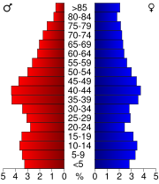
In the county the population was spread out with 24.10% under the age of 18, 7.60% from 18 to 24, 28.10% from 25 to 44, 23.00% from 45 to 64, and 17.20% who were 65 years of age or older. The median age was 39 years. For every 100 females there were 99.60 males. For every 100 females age 18 and over, there were 97.30 males.
The median income for a household in the county was $36,561, and the median income for a family was $43,342. Males had a median income of $32,344 versus $22,522 for females. The per capita income
for the county was $17,937. About 6.50% of families and 9.50% of the population were below the poverty line, including 13.40% of those under age 18 and 10.20% of those age 65 or over.
U.S. state
A U.S. state is any one of the 50 federated states of the United States of America that share sovereignty with the federal government. Because of this shared sovereignty, an American is a citizen both of the federal entity and of his or her state of domicile. Four states use the official title of...
of Illinois
Illinois
Illinois is the fifth-most populous state of the United States of America, and is often noted for being a microcosm of the entire country. With Chicago in the northeast, small industrial cities and great agricultural productivity in central and northern Illinois, and natural resources like coal,...
. According to the 2010 census, it has a population of 34,800, which is a decrease of 1.6% from 35,372 in 2000. Its county seat
County seat
A county seat is an administrative center, or seat of government, for a county or civil parish. The term is primarily used in the United States....
is Taylorville
Taylorville, Illinois
Taylorville is a city in Christian County, Illinois, United States. The population was 11,246 at the 2010 census. It is the county seat and largest city in Christian County.-Geography:Taylorville is located at ....
.
The Taylorville Micropolitan Statistical Area includes all of Christian County.
History
Christian County was formed February 15, 1839 out of SangamonSangamon County, Illinois
Sangamon County is a county located in the U.S. state of Illinois. According to the 2010 census, it has a population of 197,465, which is an increase of 4.5% from 188,951 in 2000...
, Montgomery and Shelby Counties. It was named for Christian County, Kentucky
Christian County, Kentucky
Christian County is a county located in the U.S. state of Kentucky. It was formed in 1797. As of 2000, its population was 72,265. Its county seat is Hopkinsville, Kentucky...
.
Geography
According to the 2010 census, the county has a total area of 715.64 square miles (1,853.5 km²), of which 709.38 square miles (1,837.3 km²) (or 99.13%) is land and 6.26 square miles (16.2 km²) (or 0.87%) is water.Adjacent counties
- Macon County (northeast)
- Shelby County (southeast)
- Montgomery County (southwest)
- Sangamon CountySangamon County, IllinoisSangamon County is a county located in the U.S. state of Illinois. According to the 2010 census, it has a population of 197,465, which is an increase of 4.5% from 188,951 in 2000...
(northwest)
Major highways
-
 US Route 51
 -
 Illinois Route 16Illinois Route 16Illinois Route 16 is an arterial east–west highway in central Illinois. Its western terminus is at the Joe Page Bridge over the Illinois River in Hardin, while its eastern terminus is at Paris at Illinois Route 1 and U.S. Route 150, with Illinois Route 133. This is a distance of .- Route...
 -
 Illinois Route 29Illinois Route 29Illinois Route 29 is a two to four lane state road that runs south from U.S. Route 6/Illinois Route 89 at Spring Valley to U.S. Route 51/Illinois Route 16 at Pana, running through Pekin, Peoria and Springfield. The nearest major north–south highway, Interstate 39, runs parallel to Illinois...
 -
 Illinois Route 48Illinois Route 48Illinois Route 48 is a north–south highway with its southern terminus at I-55 and Illinois Route 127 in Raymond and its northern terminus at Illinois Route 54 east of Clinton. This is a distance of .- Route description :...
 -
 Illinois Route 104Illinois Route 104Illinois Route 104 is a state highway in central and western Illinois. It extends from Illinois Route 29 near Taylorville, west over the Illinois River at Meredosia to its western terminus in downtown Quincy. This is a distance of .- Route description :...
Political subdivisions
Cities
- AssumptionAssumption, IllinoisAssumption is a city in Christian County, Illinois, United States. The population was 1,168 at the 2010 census.-Geography:Assumption is located at .According to the United States Census Bureau, the city has a total area of , all of it land.-Demographics:...
- PanaPana, IllinoisPana is a city in Christian County, Illinois, United States. The population was 5,847 at the 2010 census.-Geography:Pana is located at .According to the United States Census Bureau, the city has a total area of , all of it land....
- TaylorvilleTaylorville, IllinoisTaylorville is a city in Christian County, Illinois, United States. The population was 11,246 at the 2010 census. It is the county seat and largest city in Christian County.-Geography:Taylorville is located at ....
Villages
|
Mount Auburn, Illinois Mount Auburn is a village in Christian County, Illinois, United States. The population was 480 at the 2010 census.-Geography:Mount Auburn is located at .... Moweaqua, Illinois Moweaqua is a village in Shelby County, Illinois, United States, and partly in Christian County, Illinois. The population was 1,831 at the 2010 census.-Geography:Decatur is located at .... (west quarter) Owaneco, Illinois Owaneco is a village in Christian County, Illinois, United States. The population was 239 at the 2010 census.-Geography:Owaneco is located at .... Palmer, Illinois Palmer is a village in Christian County, Illinois, United States. The population was 229 at the 2010 census.-Geography:Palmer is located at .... Stonington, Illinois Stonington is a village in Christian County, Illinois, United States. The population was 932 at the 2010 census.-Geography:Stonington is located at .... Tovey, Illinois Tovey is a village in Christian County, Illinois, United States. The town's population was 512 at the 2010 census.-Geography:Tovey is located at .... |
Unincorporated
|
Old Stonington, Illinois Old Stonington is an unincorporated community in Christian County, Illinois, United States. It lies at .... Radford, Illinois Radford is an unincorporated community in Christian County, Illinois, United States. It lies at .... Rosamond, Illinois Rosamond is an unincorporated community in Rosamond Township, Christian County, Illinois, United States. It lies at .-History:The earliest known local resident was Capt. Alfred Cowgill who settled in the area in 1856. Cowgill moved to Assumption for a few years, returning to Rosamond where he... Sharpsburg, Illinois Sharpsburg, or Sharpsburgh, is an unincorporated community in Christian County, Illinois.According to the [ U.S.G.S.] it is located at 39.6139358 latitude and -89.3512000 longitude.-References:... Willey Station, Illinois Willey Station is an unincorporated community in Christian County, Illinois, United States. It lies on land donated by , for whom it was named. He arrived in Christian County in 1845. The town was laid out by , who built and owned the station house... |
Townships
Christian County is divided into these seventeen townshipCivil township
A civil township is a widely used unit of local government in the United States, subordinate to, and geographic divisions of, a county. Specific responsibilities and the degree of autonomy vary based on each state. Civil townships are distinct from survey townships, but in states that have both,...
s:
|
Locust Township, Christian County, Illinois Locust Township is one of seventeen townships in Christian County, Illinois, USA. As of the 2000 census, its population was 1,856.-Geography:... May Township, Christian County, Illinois May Township is one of seventeen townships in Christian County, Illinois, USA. As of the 2000 census, its population was 1,436.- History :May Township was established November 7, 1865, as Smith Township, but was later changed to Howard, then Penn, and finally to May. References as to when the name... Mosquito Township, Christian County, Illinois Mosquito Township is one of seventeen townships in Christian County, Illinois, USA. As of the 2000 census, its population was 362.-Geography:According to the United States Census Bureau, Mosquito Township covers an area of .-Unincorporated towns:... Mount Auburn Township, Christian County, Illinois Mount Auburn Township is one of seventeen townships in Christian County, Illinois, USA. As of the 2000 census, its population was 1,031.-Geography:... Pana Township, Christian County, Illinois Pana Township is one of seventeen townships in Christian County, Illinois, USA. As of the 2000 census, its population was 6,860.-Geography:According to the United States Census Bureau, Pana Township covers an area of ; of this, is land and is water.-Major highways:* U.S... Prairieton Township, Christian County, Illinois Prairieton Township is one of seventeen townships in Christian County, Illinois, USA. As of the 2000 census, its population was 492.-Geography:... |
Ricks Township, Christian County, Illinois Ricks Township is one of seventeen townships in Christian County, Illinois, USA. As of the 2000 census, its population was 1,272.-Geography:... Rosamond Township, Christian County, Illinois Rosamond Township is one of seventeen townships in Christian County, Illinois, USA. As of the 2000 census, its population was 400.-Geography:According to the United States Census Bureau, Rosamond Township covers an area of .-Unincorporated towns:... South Fork Township, Christian County, Illinois South Fork Township is one of seventeen townships in Christian County, Illinois, USA. As of the 2000 census, its population was 2,696.-Geography:... Stonington Township, Christian County, Illinois Stonington Township is one of seventeen townships in Christian County, Illinois, USA. As of the 2000 census, its population was 1,180.-Geography:According to the United States Census Bureau, Stonington Township covers an area of .-Unincorporated towns:... Taylorville Township, Christian County, Illinois Taylorville Township is one of seventeen townships in Christian County, Illinois, USA. As of the 2000 census, its population was 12,659.-Geography:... |
Notable persons from Christian County
- Harry Forrester - member of the Illinois Basketball Hall of Fame and Quincy University Hall of Fame.
- Jon CorzineJon CorzineJon Stevens Corzine is the former CEO of Goldman Sachs and of MF Global, and a one time American politician, who served as the 54th Governor of New Jersey from 2006 to 2010. A Democrat, Corzine served five years of a six-year U.S. Senate term representing New Jersey before being elected Governor...
- Former governor of New JerseyNew JerseyNew Jersey is a state in the Northeastern and Middle Atlantic regions of the United States. , its population was 8,791,894. It is bordered on the north and east by the state of New York, on the southeast and south by the Atlantic Ocean, on the west by Pennsylvania and on the southwest by Delaware...
, former resident of Willey StationWilley Station, IllinoisWilley Station is an unincorporated community in Christian County, Illinois, United States. It lies on land donated by , for whom it was named. He arrived in Christian County in 1845. The town was laid out by , who built and owned the station house...
.
Demographics
As of the U.S. Census of 2000
United States Census, 2000
The Twenty-second United States Census, known as Census 2000 and conducted by the Census Bureau, determined the resident population of the United States on April 1, 2000, to be 281,421,906, an increase of 13.2% over the 248,709,873 persons enumerated during the 1990 Census...
, there were 35,372 people, 13,921 households, and 9,480 families residing in the county. The population density
Population density
Population density is a measurement of population per unit area or unit volume. It is frequently applied to living organisms, and particularly to humans...
was 50 people per square mile (19/km²). There were 14,992 housing units at an average density of 21 per square mile (8/km²). The racial makeup of the county was 96.34% White
Race (United States Census)
Race and ethnicity in the United States Census, as defined by the Federal Office of Management and Budget and the United States Census Bureau, are self-identification data items in which residents choose the race or races with which they most closely identify, and indicate whether or not they are...
, 2.14% Black
Race (United States Census)
Race and ethnicity in the United States Census, as defined by the Federal Office of Management and Budget and the United States Census Bureau, are self-identification data items in which residents choose the race or races with which they most closely identify, and indicate whether or not they are...
or African American
Race (United States Census)
Race and ethnicity in the United States Census, as defined by the Federal Office of Management and Budget and the United States Census Bureau, are self-identification data items in which residents choose the race or races with which they most closely identify, and indicate whether or not they are...
, 0.16% Native American
Race (United States Census)
Race and ethnicity in the United States Census, as defined by the Federal Office of Management and Budget and the United States Census Bureau, are self-identification data items in which residents choose the race or races with which they most closely identify, and indicate whether or not they are...
, 0.37% Asian
Race (United States Census)
Race and ethnicity in the United States Census, as defined by the Federal Office of Management and Budget and the United States Census Bureau, are self-identification data items in which residents choose the race or races with which they most closely identify, and indicate whether or not they are...
, 0.03% Pacific Islander
Race (United States Census)
Race and ethnicity in the United States Census, as defined by the Federal Office of Management and Budget and the United States Census Bureau, are self-identification data items in which residents choose the race or races with which they most closely identify, and indicate whether or not they are...
, 0.47% from other races
Race (United States Census)
Race and ethnicity in the United States Census, as defined by the Federal Office of Management and Budget and the United States Census Bureau, are self-identification data items in which residents choose the race or races with which they most closely identify, and indicate whether or not they are...
, and 0.48% from two or more races. 0.98% of the population were Hispanic
Race (United States Census)
Race and ethnicity in the United States Census, as defined by the Federal Office of Management and Budget and the United States Census Bureau, are self-identification data items in which residents choose the race or races with which they most closely identify, and indicate whether or not they are...
or Latino
Race (United States Census)
Race and ethnicity in the United States Census, as defined by the Federal Office of Management and Budget and the United States Census Bureau, are self-identification data items in which residents choose the race or races with which they most closely identify, and indicate whether or not they are...
of any race. 26.7% were of German, 20.5% American
United States
The United States of America is a federal constitutional republic comprising fifty states and a federal district...
, 11.9% English
English people
The English are a nation and ethnic group native to England, who speak English. The English identity is of early mediaeval origin, when they were known in Old English as the Anglecynn. England is now a country of the United Kingdom, and the majority of English people in England are British Citizens...
, 10.6% Irish
Irish people
The Irish people are an ethnic group who originate in Ireland, an island in northwestern Europe. Ireland has been populated for around 9,000 years , with the Irish people's earliest ancestors recorded having legends of being descended from groups such as the Nemedians, Fomorians, Fir Bolg, Tuatha...
and 6.9% Italian
Italian people
The Italian people are an ethnic group that share a common Italian culture, ancestry and speak the Italian language as a mother tongue. Within Italy, Italians are defined by citizenship, regardless of ancestry or country of residence , and are distinguished from people...
ancestry according to Census 2000. 98.1% spoke English
English language
English is a West Germanic language that arose in the Anglo-Saxon kingdoms of England and spread into what was to become south-east Scotland under the influence of the Anglian medieval kingdom of Northumbria...
and 1.1% Spanish
Spanish language
Spanish , also known as Castilian , is a Romance language in the Ibero-Romance group that evolved from several languages and dialects in central-northern Iberia around the 9th century and gradually spread with the expansion of the Kingdom of Castile into central and southern Iberia during the...
as their first language.
There were 13,921 households out of which 30.40% had children under the age of 18 living with them, 55.30% were married couples
Marriage
Marriage is a social union or legal contract between people that creates kinship. It is an institution in which interpersonal relationships, usually intimate and sexual, are acknowledged in a variety of ways, depending on the culture or subculture in which it is found...
living together, 9.10% had a female householder with no husband present, and 31.90% were non-families. 28.40% of all households were made up of individuals and 14.70% had someone living alone who was 65 years of age or older. The average household size was 2.41 and the average family size was 2.94.
In the county the population was spread out with 24.10% under the age of 18, 7.60% from 18 to 24, 28.10% from 25 to 44, 23.00% from 45 to 64, and 17.20% who were 65 years of age or older. The median age was 39 years. For every 100 females there were 99.60 males. For every 100 females age 18 and over, there were 97.30 males.
The median income for a household in the county was $36,561, and the median income for a family was $43,342. Males had a median income of $32,344 versus $22,522 for females. The per capita income
Per capita income
Per capita income or income per person is a measure of mean income within an economic aggregate, such as a country or city. It is calculated by taking a measure of all sources of income in the aggregate and dividing it by the total population...
for the county was $17,937. About 6.50% of families and 9.50% of the population were below the poverty line, including 13.40% of those under age 18 and 10.20% of those age 65 or over.
Climate and weather
In recent years, average temperatures in the county seat of Taylorville have ranged from a low of 16 °F (-8.9 °C) in January to a high of 86 °F (30 °C) in July, although a record low of -23 °F was recorded in January 1994 and a record high of 104 °F (40 °C) was recorded in August 1988. Average monthly precipitation ranged from 1.78 inches (4.5 cm) in January to 3.77 inches (9.6 cm) in May.See also
- National Register of Historic Places listings in Christian County, Illinois