
Late-May 2008 tornado outbreak sequence
Encyclopedia
The Late May 2008 tornado outbreak sequence was a series of tornado outbreak
s affecting the central plains
of the United States
since May 22, 2008. Over 250 tornadoes were reported across many states and two Canadian provinces from Wyoming
to Ohio
and from Manitoba
to Texas
, of which at least 235 were confirmed. One person was killed when a tornado struck portions of Weld County, Colorado
, and two more deaths were reported in Pratt County, Kansas
. One person was also killed near Hugo, Minnesota
on May 25 and nine were killed from an EF5 tornado that destroyed most of Parkersburg, Iowa
and some of New Hartford, Iowa
(located near Waterloo, Iowa
). Another death, caused by lightning related to the storms, took place in central Kansas.
 On May 22, a low pressure system
developed across the Rocky Mountains
, with a warm front stretching across the central Plains and a trough stretching north towards Alberta
and eastern British Columbia
. A moderate risk had already been issued for portions of northern Kansas on May 21, and was upgraded into a high risk during the afternoon of May 22. It was the first high risk outlook in Kansas since May 5, 2007, one day after an EF5 tornado
hit Greensburg, Kansas
.
Severe thunderstorm and tornado watches extended from eastern Wyoming into northern Kansas early on May 22. Just before noon, a mile-wide (1.6 km) tornado was reported near Greeley, Colorado
which is about one hour north of Denver
. It moved northwest, an unusual path for tornadoes. It struck the town of Windsor
, causing extensive damage to some buildings, although lesser damage was reported to some homes according to some video footage. One person was killed at the Missile Silo Campground near Greeley. Another tornado struck the city of Laramie, Wyoming
causing some damage to some roofs of businesses and tossing trucks across Interstate 80
.
Numerous tornadoes were reported across northern Kansas, however damage was limited due to the sparsely populated areas it affected. Another intense storm traveled across northern Oklahoma
during the evening hours. At least 45 tornadoes were reported across the region on May 22.
On May 23, thunderstorms fired up across much of the same areas, where a moderate risk of severe storms was issued for northern Kansas. Tornado watches stretched from Wyoming into Oklahoma. Supercells were reported across northern Kansas and Colorado as well as southern Kansas were an intense supercell was traveling near the areas hit by powerful tornadoes
on May 4–5, 2007. An EF4 tornado affected Quinter
, and other tornadoes hit the towns of Ellis and Protection. Greensburg, still in the rebuilding process from the EF5 tornado that affected the town more than one year prior, narrowly missed getting struck again. Homes and trailers were also reported destroyed in Pratt
and Lane
Counties. There were 55 tornadoes confirmed in the Dodge City
warning area alone and over 80 tornadoes confirmed that day and night, with two deaths reported in Pratt County and at least five people were injured in Kansas alone with the most across Stafford County
.
On May 24, a slight risk was issued for much of the Missouri River
corridor as well as areas along Interstate 35
from Kansas City
to Oklahoma City
and later into portions of northern Texas
. Tornado watch
es were issued from Minnesota
(at the Canadian border) to Oklahoma with a severe thunderstorm watch
in parts of Texas. One thunderstorm produced several tornadoes across Kingfisher
and Garfield
Counties south of Enid
. Most tornadoes were caught on tape by a helicopter reporter for KWTV-TV in Oklahoma City
which was also repeatedly broadcast on CNN
. One of the tornadoes captured live on CNN and KWTV destroyed a hog farm. None of the employees who worked at the farm were injured, although a few pigs inside the structures were hurt. However, none of the pigs were found dead. Tornadoes were also reported across the Dakotas during the evening hours for a total of 13 reports throughout the day.
 On May 25, notices for moderate risk of severe weather were issued for northern Kansas, southern Nebraska, eastern Minnesota, northeastern Iowa, and western Wisconsin with a slight risk from Texas to northwestern Ontario. Watches extended along all the corridor and storms developed in four different areas including and northern Texas, northern Kansas, central Minnesota and Iowa and southern Manitoba. One tornado near Cedar Falls
and Waterloo
was reported to have caused major damage in Parkersburg, Iowa
in Butler County
. Homes were also reported destroyed in Dunkerton
and near the Waterloo Municipal Airport. That tornado killed nine people and was later rated an EF5, the first since the Greensburg, Kansas tornado. According to the SPC Storm Reports, 50 tornadoes have been reported throughout the day.
At 4:55 pm, an EF3 tornado touched down in Lino Lakes
, a northern suburb of the Minneapolis-St. Paul area. The tornado then moved into Hugo
where it caused major damage. Around 50 houses were destroyed and 150 damaged in Creek View Preserve and Water's Edge neighborhoods of Hugo, and 500 homes were damaged in total. A two year old child was killed and nine people were seriously injured.
A moderate risk of severe weather was issued for central Kansas from the same storm system for May 26 while a large slight risk area was issued by the SPC from Texas to southern Quebec
and Ontario
, while Environment Canada
issued a slight risk for severe weather for southwestern Ontario. The moderate risk in Kansas was a bust as the severe weather was limited to just a few tornadoes across western Texas and central Kansas. Meanwhile, only isolated strong thunderstorms across southern and eastern Ontario during the evening hours while very limited activity across the Great Lakes
and Ohio Valley regions. However two weak tornadoes were later confirmed north of Sudbury and North Bay
. Minimal severe activity was reported on May 27 and May 28.
 On May 29, the SPC issued a high risk of severe weather across eastern Nebraska and western Iowa including the Omaha, Nebraska
metropolitan, with a moderate risk affecting southern Minnesota, much of central Iowa including Des Moines
, northern Kansas and southern South Dakota
. At least 20 tornadoes were reported including three that struck the city of Kearney, causing damage at the University of Nebraska
campus in Kearney
as well as the Buffalo County Fairgrounds
, the Kearney Regional Airport, businesses and homes. Part of Interstate 80
near Aurora, Nebraska
was closed due to downed power lines from a tornado. Another tornado caused major damage in the town of Jewell, Kansas
particularly on the south side of the town where it was reported that a large tornado was on ground in Jewell County
. Significant damage was also reported in Republic County
in Kansas and in Jefferson County
in Nebraska. Tornadoes continued throughout the overnight hours across Iowa where 10 people were injured from an EF2 tornado. There were no immediate reports of fatalities directly associated from tornadoes.
For May 30, the SPC issued a moderate risk of severe weather for northern and central Illinois
, southeastern Michigan
, northern Indiana
and northeastern Missouri
. Tornadoes were reported near Springfield, Illinois
although the heaviest damage was reported across northwestern Ohio where some homes were destroyed in Putnam
and Seneca
Counties. People were reportedly being trapped inside damage structures although there were no reports of fatalities.
For May 31, a moderate risk was issued for portions of the Middle Atlantic states including portions of the Interstate 95
from Virginia
to New York City
. Further southwest along the front, a moderate risk was issued for areas along the Kansas-Oklahoma state line. Activity was mostly limited to hail and damaging wind events although a few tornadoes were reported.
, but are included in the chart below using their number rated.
which is about one hour north of Denver. The tornado was caught on tape and golfball size hail accompanied the storm as it traveled near Interstate 25. It moved into an unusual path towards the northwest and struck the town of Windsor
causing extensive damage to some buildings although lesser damage was reported to some homes according to some video footage. One person was reported killed at the Missile Silo Campground near Greeley.
About 100 homes were destroyed or damaged beyond repair with about another 500 homes suffering other forms of damage. Businesses were also damaged and trailers overturned. The tornado also caused damage to the Windmill Daycare Center where about 150 children were located but none were injured as they took cover from the storm which blew most windows of the building. The Weld County tornado was the first killer and EF3 tornado in Colorado since an EF3 hit Holly
in Kiowa County
near the Kansas state line. That tornado killed two as part of a similar outbreak on March 28, 2007
. It was estimated that the May 22 storms were the state's fourth costliest disaster ever with $147 million in estimated insured damage.
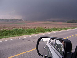
 A strong supercell developed in northeast Iowa
, west of Waterloo
in the late afternoon of May 25, 2008. The first tornado warning of the cell was issued at 4:22 pm CDT (2122 UTC) for the Parkersburg
area, The first tornado from this cell was reported near Aplington
in Butler County
at 4:48 pm CDT. It then tracked toward Parkersburg, slamming into the southern part of the community just before 5:00 pm CDT. At that time, the tornado was estimated to be about 7/10 mile (1.1 km) wide. After passing through Parkersburg, the tornado continued eastward toward New Hartford
, impacting a housing development near the community at 5:09 pm CDT. The tornado then passed just north of Waterloo
and Cedar Falls
and shrunk to about 1/4 mile (400 m) in width as it continued to impact rural areas. As the tornado approached Dunkerton
, it turned to the east-northeast and grew to 1.2 miles (2 km) wide. Shortly before reaching Fairbank
, the tornado likely dissipated, at which point it was replaced by a second tornado, about a mile and a half south of Fairbank.
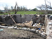
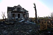
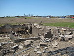 Catastrophic damage was reported in Parkersburg as much of the town was destroyed, with reports of flattened houses and debarked trees. Seven people were killed in Parkersburg and two were killed in New Hartford, where a housing development was destroyed. At least 70 people were injured.
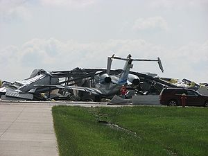
Farther east, Waterloo Regional Airport
reported a 93 mph (150 km/h) wind gust, and houses were destroyed just northwest of the airport. The storm passed south of Fairbank
where numerous farm houses were destroyed. There were more reports of destroyed houses in Dunkerton
and mobile homes were destroyed and thrown around in Hazelton. Damage was also reported near Dundee
before the tornado dissipated. The damage may have been caused by one or multiple tornadoes. A final assessment determined that the tornado was an EF5 with estimated peak winds of about 205 miles per hour (330 km/h). Damage in the eastern part of the track was rated EF3 according to the NWS office in the Quad Cities
. 288 homes in Parkersburg, 88 in New Hartford, 15 in Hazelton and another 50 in Black Hawk County were destroyed by the tornado. According to FEMA
and the Iowa Homeland Security and Emergency Management, damage was preliminary estimated at around $6 million in northern Iowa including more than $3 million in Butler County
alone. While the tornado was caught on tape and photographed by spotters, a surveillance camera inside a bank in Parkersburg also caught the tornado on tape as the storm passed over the building. Another surveillance camera shows the tornado ripping the roof of a home across a street before the video was lost.
 After the tornado, Governor Chet Culver
declared Butler
and Black Hawk
counties disaster area
s due to the extensive storm damage. The tornado was the first F5 or EF5 tornado in Iowa since one hit Jordan
on June 13, 1976 and the second deadliest in Iowa since official record-keeping began in 1950. The deadliest tornado
affected the Charles City
area on May 15, 1968 and killed 13 while producing F5 damage.
On May 29, the Waterloo-Cedar Falls Courier
reported that lightweight debris from the Waterloo area, including photographs, check stubs, and "greeting cards and business records" from a Waterloo Walgreens
, had been found in Prairie du Chien, Wisconsin, over 100 miles (160.9 km) away.
 Three tornado touchdowns were confirmed in the northern suburbs of the Minneapolis-St. Paul area on May 25. The first tornado touched down in heavily populated Coon Rapids
, and was rated EF1. It toppled trees and caused damage to several roofs in Coon Rapids before lifting off the ground 6 miles (10 km) later in Blaine
.
A second, more powerful tornado touched down at 4:55 pm in Lino Lakes
. It caused some minor damage to some structures before it strengthened to an EF3 as it crossed into Washington County and into the town of Hugo
. Around 50 houses were destroyed and 150 damaged in Creek View Preserve and Water's Edge neighborhoods of Hugo. A two year old child was killed when he was thrown from his house, and his sister and parents were among nine people who were seriously injured. This was the first tornado fatality in Minnesota since September 16, 2006. Following the tornado up to 400 homes were evacuated because of downed power lines and gas leaks, and authorities went door to door to search for more injured. Up to 20 people had initially been unaccounted for, but all were located by later that night. A 62 year old woman died four days after the tornado when she suffered a heart attack while clearing debris from her yard. Her house was severely damaged by the tornado, and she had been treated for injuries immediately afterwards. Extensive damage occurred during this storm from hail up to the size of baseballs north of the Twin Cities. Up to 15,000 people lost power.
which threatened to overflow near the Calgary
area. Several areas across the province were under flood warnings.
On May 29–30, Ames, Iowa
, was soaked with between 4 and 5 inches (127 mm) of rain on already-saturated soil, leading to much of south Ames and the campus of Iowa State University
being submerged under several feet of water, and forcing the evacuation of thousands of people. Floodwaters also closed down two major highways: U.S. Route 30
and U.S. Route 69
. Longtime Ames residents said that the flooding was the worst to hit Ames since the Great Flood of 1993
.
Tornado outbreak
While there is no single agreed upon definition, generally at least 6-10 tornadoes produced by the same synoptic scale weather system is considered a tornado outbreak. The tornadoes usually occur within the same day, or continue into the early morning hours of the succeeding day, and within the...
s affecting the central plains
Midwestern United States
The Midwestern United States is one of the four U.S. geographic regions defined by the United States Census Bureau, providing an official definition of the American Midwest....
of the United States
United States
The United States of America is a federal constitutional republic comprising fifty states and a federal district...
since May 22, 2008. Over 250 tornadoes were reported across many states and two Canadian provinces from Wyoming
Wyoming
Wyoming is a state in the mountain region of the Western United States. The western two thirds of the state is covered mostly with the mountain ranges and rangelands in the foothills of the Eastern Rocky Mountains, while the eastern third of the state is high elevation prairie known as the High...
to Ohio
Ohio
Ohio is a Midwestern state in the United States. The 34th largest state by area in the U.S.,it is the 7th‑most populous with over 11.5 million residents, containing several major American cities and seven metropolitan areas with populations of 500,000 or more.The state's capital is Columbus...
and from Manitoba
Manitoba
Manitoba is a Canadian prairie province with an area of . The province has over 110,000 lakes and has a largely continental climate because of its flat topography. Agriculture, mostly concentrated in the fertile southern and western parts of the province, is vital to the province's economy; other...
to Texas
Texas
Texas is the second largest U.S. state by both area and population, and the largest state by area in the contiguous United States.The name, based on the Caddo word "Tejas" meaning "friends" or "allies", was applied by the Spanish to the Caddo themselves and to the region of their settlement in...
, of which at least 235 were confirmed. One person was killed when a tornado struck portions of Weld County, Colorado
Weld County, Colorado
As of the census of 2000, there were 180,936 people, 63,247 households, and 45,221 families residing in the county. The population density was 45 people per square mile . There were 66,194 housing units at an average density of 17 per square mile...
, and two more deaths were reported in Pratt County, Kansas
Pratt County, Kansas
Pratt County is a county located in the U.S. state of Kansas. As of the 2010 census, the county population was 9,656. The largest city and county seat is Pratt.-19th century:...
. One person was also killed near Hugo, Minnesota
Hugo, Minnesota
As of the census of 2000, there were 6,363 people, 2,125 households, and 1,742 families residing in the city. The population density was 187.2 people per square mile . There were 2,174 housing units at an average density of 64.0 per square mile...
on May 25 and nine were killed from an EF5 tornado that destroyed most of Parkersburg, Iowa
Parkersburg, Iowa
Parkersburg is a city in Butler County, Iowa, United States. The population was 1,870 in the 2010 census, a decline from 1,889 in the 2000 census. Parkersburg, although not the county seat, has the highest population of all the cities in Butler County....
and some of New Hartford, Iowa
New Hartford, Iowa
New Hartford is a city in Butler County, Iowa, United States. The population was 516 at the 2010 census. It is the hometown of U.S. Senator Chuck Grassley of Iowa.-Geography:...
(located near Waterloo, Iowa
Waterloo, Iowa
Waterloo is a city in and the county seat of Black Hawk County, Iowa, United States. As of the 2010 United States Census the population decreased by 0.5% to 68,406. Waterloo is part of the Waterloo – Cedar Falls Metropolitan Statistical Area, and is the more populous of the two...
). Another death, caused by lightning related to the storms, took place in central Kansas.
Meteorological synopsis
Low pressure area
A low-pressure area, or "low", is a region where the atmospheric pressure at sea level is below that of surrounding locations. Low-pressure systems form under areas of wind divergence which occur in upper levels of the troposphere. The formation process of a low-pressure area is known as...
developed across the Rocky Mountains
Rocky Mountains
The Rocky Mountains are a major mountain range in western North America. The Rocky Mountains stretch more than from the northernmost part of British Columbia, in western Canada, to New Mexico, in the southwestern United States...
, with a warm front stretching across the central Plains and a trough stretching north towards Alberta
Alberta
Alberta is a province of Canada. It had an estimated population of 3.7 million in 2010 making it the most populous of Canada's three prairie provinces...
and eastern British Columbia
British Columbia
British Columbia is the westernmost of Canada's provinces and is known for its natural beauty, as reflected in its Latin motto, Splendor sine occasu . Its name was chosen by Queen Victoria in 1858...
. A moderate risk had already been issued for portions of northern Kansas on May 21, and was upgraded into a high risk during the afternoon of May 22. It was the first high risk outlook in Kansas since May 5, 2007, one day after an EF5 tornado
May 2007 Tornado Outbreak
The May 2007 Tornado Outbreak was an extended tornado outbreak that started on May 4, 2007, affecting portions of the Central United States. The most destructive tornado in the outbreak occurred on the evening of May 4 in western Kansas, where about 95% of the city of Greensburg in Kiowa County was...
hit Greensburg, Kansas
Greensburg, Kansas
Greensburg is a city in and the county seat of Kiowa County, Kansas, United States. As of the 2010 census, the city population was 777. Greensburg is also home to the world's largest hand-dug well....
.
Severe thunderstorm and tornado watches extended from eastern Wyoming into northern Kansas early on May 22. Just before noon, a mile-wide (1.6 km) tornado was reported near Greeley, Colorado
Greeley, Colorado
The City of Greeley is a Home Rule Municipality that is the county seat and the most populous city of Weld County, Colorado, United States. Greeley is located in the region known as Northern Colorado. Greeley is situated north-northeast of the Colorado State Capitol in Denver. According to the...
which is about one hour north of Denver
Denver, Colorado
The City and County of Denver is the capital and the most populous city of the U.S. state of Colorado. Denver is a consolidated city-county, located in the South Platte River Valley on the western edge of the High Plains just east of the Front Range of the Rocky Mountains...
. It moved northwest, an unusual path for tornadoes. It struck the town of Windsor
Windsor, Colorado
The Town of Windsor is a Home Rule Municipality in Larimer and Weld counties in the U.S. state of Colorado. According to the 2010 Census, the population of the town was 18,644. Windsor is located in the region known as Northern Colorado. Windsor is situated north of the Colorado State Capitol in...
, causing extensive damage to some buildings, although lesser damage was reported to some homes according to some video footage. One person was killed at the Missile Silo Campground near Greeley. Another tornado struck the city of Laramie, Wyoming
Laramie, Wyoming
Laramie is a city in and the county seat of Albany County, Wyoming, United States. The population was 30,816 at the . Located on the Laramie River in southeastern Wyoming, the city is west of Cheyenne, at the junction of Interstate 80 and U.S. Route 287....
causing some damage to some roofs of businesses and tossing trucks across Interstate 80
Interstate 80
Interstate 80 is the second-longest Interstate Highway in the United States, following Interstate 90. It is a transcontinental artery running from downtown San Francisco, California to Teaneck, New Jersey in the New York City Metropolitan Area...
.
Numerous tornadoes were reported across northern Kansas, however damage was limited due to the sparsely populated areas it affected. Another intense storm traveled across northern Oklahoma
Oklahoma
Oklahoma is a state located in the South Central region of the United States of America. With an estimated 3,751,351 residents as of the 2010 census and a land area of 68,667 square miles , Oklahoma is the 28th most populous and 20th-largest state...
during the evening hours. At least 45 tornadoes were reported across the region on May 22.
On May 23, thunderstorms fired up across much of the same areas, where a moderate risk of severe storms was issued for northern Kansas. Tornado watches stretched from Wyoming into Oklahoma. Supercells were reported across northern Kansas and Colorado as well as southern Kansas were an intense supercell was traveling near the areas hit by powerful tornadoes
May 2007 Tornado Outbreak
The May 2007 Tornado Outbreak was an extended tornado outbreak that started on May 4, 2007, affecting portions of the Central United States. The most destructive tornado in the outbreak occurred on the evening of May 4 in western Kansas, where about 95% of the city of Greensburg in Kiowa County was...
on May 4–5, 2007. An EF4 tornado affected Quinter
Quinter, Kansas
Quinter is a city in Gove County, Kansas, United States. As of the 2010 census, the city population was 918.-History:The city of Quinter is built at the location of an old railroad switching site called Melota. A town named Familton was built there in 1885, consisting originally of a two-story...
, and other tornadoes hit the towns of Ellis and Protection. Greensburg, still in the rebuilding process from the EF5 tornado that affected the town more than one year prior, narrowly missed getting struck again. Homes and trailers were also reported destroyed in Pratt
Pratt County, Kansas
Pratt County is a county located in the U.S. state of Kansas. As of the 2010 census, the county population was 9,656. The largest city and county seat is Pratt.-19th century:...
and Lane
Lane County, Kansas
Lane County is a county located in the U.S. state of Kansas. As of the 2010 census, the county population was 1,750. The county seat is Dighton, the only city in the county. Lane County was named after James H. Lane who was a leader of the Jayhawker abolitionist movement and served as one of...
Counties. There were 55 tornadoes confirmed in the Dodge City
Dodge City, Kansas
Dodge City is a city in, and the county seat of, Ford County, Kansas, United States. Named after nearby Fort Dodge, the city is famous in American culture for its history as a wild frontier town of the Old West. As of the 2010 census, the city population was 27,340.-History:The first settlement of...
warning area alone and over 80 tornadoes confirmed that day and night, with two deaths reported in Pratt County and at least five people were injured in Kansas alone with the most across Stafford County
Stafford County, Kansas
Stafford County is a county located in the U.S. state of Kansas. As of the 2010 census, the county population was 4,437. Its county seat is St. John...
.
On May 24, a slight risk was issued for much of the Missouri River
Missouri River
The Missouri River flows through the central United States, and is a tributary of the Mississippi River. It is the longest river in North America and drains the third largest area, though only the thirteenth largest by discharge. The Missouri's watershed encompasses most of the American Great...
corridor as well as areas along Interstate 35
Interstate 35
Interstate 35 is a north–south Interstate Highway in the central United States. I-35 stretches from Laredo, Texas, on the U.S.-Mexico border to Duluth, Minnesota, at Minnesota Highway 61 and 26th Avenue East. Many interstates used to have splits or spurs indicated with suffixed letters , but I-35...
from Kansas City
Kansas City, Missouri
Kansas City, Missouri is the largest city in the U.S. state of Missouri and is the anchor city of the Kansas City Metropolitan Area, the second largest metropolitan area in Missouri. It encompasses in parts of Jackson, Clay, Cass, and Platte counties...
to Oklahoma City
Oklahoma city
Oklahoma City is the capital and largest city of the U.S. state of Oklahoma.Oklahoma City may also refer to:*Oklahoma City metropolitan area*Downtown Oklahoma City*Uptown Oklahoma City*Oklahoma City bombing*Oklahoma City National Memorial...
and later into portions of northern Texas
Texas
Texas is the second largest U.S. state by both area and population, and the largest state by area in the contiguous United States.The name, based on the Caddo word "Tejas" meaning "friends" or "allies", was applied by the Spanish to the Caddo themselves and to the region of their settlement in...
. Tornado watch
Tornado watch
A tornado watch is issued when conditions are right for a tornado to form. Since any thunderstorm capable of producing a tornado is defined as severe, a tornado watch is also automatically a severe thunderstorm watch...
es were issued from Minnesota
Minnesota
Minnesota is a U.S. state located in the Midwestern United States. The twelfth largest state of the U.S., it is the twenty-first most populous, with 5.3 million residents. Minnesota was carved out of the eastern half of the Minnesota Territory and admitted to the Union as the thirty-second state...
(at the Canadian border) to Oklahoma with a severe thunderstorm watch
Severe thunderstorm watch
[File:Annual_severe_thunderstorm_watch_frequency_in_the_United_States.svg|thumb|right|300px|Map of average annual severe thunderstorm watches in the United States between 1999 and 2008.Legend:...
in parts of Texas. One thunderstorm produced several tornadoes across Kingfisher
Kingfisher County, Oklahoma
Kingfisher County is a county located in the U.S. state of Oklahoma. As of 2000, the population was 14,384. Its county seat is Kingfisher.-History:...
and Garfield
Garfield County, Oklahoma
Garfield County is a county located in the U.S. state of Oklahoma named after President James A. Garfield. As of 2010, the population was 60,580. Enid is the county seat and largest city within Garfield County...
Counties south of Enid
Enid, Oklahoma
Enid is a city in Garfield County, Oklahoma, United States. In 2010, the population was 49,379, making it the ninth largest city in Oklahoma. It is the county seat of Garfield County. Enid was founded during the opening of the Cherokee Outlet in the Land Run of 1893, and is named after Enid, a...
. Most tornadoes were caught on tape by a helicopter reporter for KWTV-TV in Oklahoma City
Oklahoma city
Oklahoma City is the capital and largest city of the U.S. state of Oklahoma.Oklahoma City may also refer to:*Oklahoma City metropolitan area*Downtown Oklahoma City*Uptown Oklahoma City*Oklahoma City bombing*Oklahoma City National Memorial...
which was also repeatedly broadcast on CNN
CNN
Cable News Network is a U.S. cable news channel founded in 1980 by Ted Turner. Upon its launch, CNN was the first channel to provide 24-hour television news coverage, and the first all-news television channel in the United States...
. One of the tornadoes captured live on CNN and KWTV destroyed a hog farm. None of the employees who worked at the farm were injured, although a few pigs inside the structures were hurt. However, none of the pigs were found dead. Tornadoes were also reported across the Dakotas during the evening hours for a total of 13 reports throughout the day.
Cedar Falls, Iowa
Cedar Falls is a city in Black Hawk County, Iowa, United States, and it is home to one of Iowa's three public universities, the University of Northern Iowa. The population was 39,260 in the 2010 census, an increase from the 36,145 population in the 2000 census...
and Waterloo
Waterloo, Iowa
Waterloo is a city in and the county seat of Black Hawk County, Iowa, United States. As of the 2010 United States Census the population decreased by 0.5% to 68,406. Waterloo is part of the Waterloo – Cedar Falls Metropolitan Statistical Area, and is the more populous of the two...
was reported to have caused major damage in Parkersburg, Iowa
Parkersburg, Iowa
Parkersburg is a city in Butler County, Iowa, United States. The population was 1,870 in the 2010 census, a decline from 1,889 in the 2000 census. Parkersburg, although not the county seat, has the highest population of all the cities in Butler County....
in Butler County
Butler County, Iowa
-2010 census:The 2010 census recorded a population of 14,867 in the county, with a population density of . There were 6,682 housing units, of which 6,120 were occupied.-2000 census:...
. Homes were also reported destroyed in Dunkerton
Dunkerton, Iowa
Dunkerton is a city in Black Hawk County, Iowa, United States. The population was 749 at the 2000 census. It is part of the Waterloo–Cedar Falls Metropolitan Statistical Area.-History:...
and near the Waterloo Municipal Airport. That tornado killed nine people and was later rated an EF5, the first since the Greensburg, Kansas tornado. According to the SPC Storm Reports, 50 tornadoes have been reported throughout the day.
At 4:55 pm, an EF3 tornado touched down in Lino Lakes
Lino Lakes, Minnesota
As of the census of 2000, there were 16,791 people, 4,857 households, and 4,162 families residing in the city. The population density was 595.1 people per square mile . There were 4,921 housing units at an average density of 174.4 per square mile...
, a northern suburb of the Minneapolis-St. Paul area. The tornado then moved into Hugo
Hugo, Minnesota
As of the census of 2000, there were 6,363 people, 2,125 households, and 1,742 families residing in the city. The population density was 187.2 people per square mile . There were 2,174 housing units at an average density of 64.0 per square mile...
where it caused major damage. Around 50 houses were destroyed and 150 damaged in Creek View Preserve and Water's Edge neighborhoods of Hugo, and 500 homes were damaged in total. A two year old child was killed and nine people were seriously injured.
A moderate risk of severe weather was issued for central Kansas from the same storm system for May 26 while a large slight risk area was issued by the SPC from Texas to southern Quebec
Quebec
Quebec or is a province in east-central Canada. It is the only Canadian province with a predominantly French-speaking population and the only one whose sole official language is French at the provincial level....
and Ontario
Ontario
Ontario is a province of Canada, located in east-central Canada. It is Canada's most populous province and second largest in total area. It is home to the nation's most populous city, Toronto, and the nation's capital, Ottawa....
, while Environment Canada
Environment Canada
Environment Canada , legally incorporated as the Department of the Environment under the Department of the Environment Act Environment Canada (EC) (French: Environnement Canada), legally incorporated as the Department of the Environment under the Department of the Environment Act Environment...
issued a slight risk for severe weather for southwestern Ontario. The moderate risk in Kansas was a bust as the severe weather was limited to just a few tornadoes across western Texas and central Kansas. Meanwhile, only isolated strong thunderstorms across southern and eastern Ontario during the evening hours while very limited activity across the Great Lakes
Great Lakes
The Great Lakes are a collection of freshwater lakes located in northeastern North America, on the Canada – United States border. Consisting of Lakes Superior, Michigan, Huron, Erie, and Ontario, they form the largest group of freshwater lakes on Earth by total surface, coming in second by volume...
and Ohio Valley regions. However two weak tornadoes were later confirmed north of Sudbury and North Bay
North Bay, Ontario
North Bay is a city in Northeastern Ontario, Canada. It is the seat of Nipissing District, and takes its name from its position on the shore of Lake Nipissing.-History:...
. Minimal severe activity was reported on May 27 and May 28.
Omaha, Nebraska
Omaha is the largest city in the state of Nebraska, United States, and is the county seat of Douglas County. It is located in the Midwestern United States on the Missouri River, about 20 miles north of the mouth of the Platte River...
metropolitan, with a moderate risk affecting southern Minnesota, much of central Iowa including Des Moines
Des Moines, Iowa
Des Moines is the capital and the most populous city in the US state of Iowa. It is also the county seat of Polk County. A small portion of the city extends into Warren County. It was incorporated on September 22, 1851, as Fort Des Moines which was shortened to "Des Moines" in 1857...
, northern Kansas and southern South Dakota
South Dakota
South Dakota is a state located in the Midwestern region of the United States. It is named after the Lakota and Dakota Sioux American Indian tribes. Once a part of Dakota Territory, South Dakota became a state on November 2, 1889. The state has an area of and an estimated population of just over...
. At least 20 tornadoes were reported including three that struck the city of Kearney, causing damage at the University of Nebraska
University of Nebraska at Kearney
The University of Nebraska at Kearney , founded in 1905 as the Nebraska State Normal School at Kearney, is the Kearney, Nebraska, United States campus of the University of Nebraska system.-History:...
campus in Kearney
Kearney, Nebraska
Kearney is a city in and the county seat of Buffalo County, Nebraska, United States. The population was 30,787 at the 2010 census. It is home to the University of Nebraska-Kearney....
as well as the Buffalo County Fairgrounds
Buffalo County, Nebraska
-Demographics:As of the census of 2000, there were 42,259 people, 15,930 households, and 10,227 families residing in the county. The population density was 44 people per square mile . There were 16,830 housing units at an average density of 17 per square mile...
, the Kearney Regional Airport, businesses and homes. Part of Interstate 80
Interstate 80
Interstate 80 is the second-longest Interstate Highway in the United States, following Interstate 90. It is a transcontinental artery running from downtown San Francisco, California to Teaneck, New Jersey in the New York City Metropolitan Area...
near Aurora, Nebraska
Aurora, Nebraska
Aurora is a city in Hamilton County, Nebraska in the United States of America. The population was 4,225 at the 2000 census. It is the county seat of Hamilton County.-Geography:...
was closed due to downed power lines from a tornado. Another tornado caused major damage in the town of Jewell, Kansas
Jewell, Kansas
Jewell is a city in Jewell County, Kansas, United States. As of the 2010 census, the city population was 432.-History:The City of Jewell began in 1870 as a large sod enclosure called Fort Jewell. Named in honor of Lieutenant-Colonel Lewis R. Jewell, Sixth Kansas Cavalry, who died November 30,...
particularly on the south side of the town where it was reported that a large tornado was on ground in Jewell County
Jewell County, Kansas
Jewell County is a county located in North Central Kansas, in the Central United States. As of the 2010 census, the county population was 3,077. Its county seat and most populous city is Mankato.-19th century:...
. Significant damage was also reported in Republic County
Republic County, Kansas
Republic County is a county located in the state of Kansas. As of the 2010 census, the county population was 4,980. The largest city and county seat is Belleville.-19th century:...
in Kansas and in Jefferson County
Jefferson County, Nebraska
-Demographics:As of the census of 2000, there were 8,333 people, 3,527 households, and 2,352 families residing in the county. The population density was 14 people per square mile . There were 3,942 housing units at an average density of 7 per square mile...
in Nebraska. Tornadoes continued throughout the overnight hours across Iowa where 10 people were injured from an EF2 tornado. There were no immediate reports of fatalities directly associated from tornadoes.
For May 30, the SPC issued a moderate risk of severe weather for northern and central Illinois
Illinois
Illinois is the fifth-most populous state of the United States of America, and is often noted for being a microcosm of the entire country. With Chicago in the northeast, small industrial cities and great agricultural productivity in central and northern Illinois, and natural resources like coal,...
, southeastern Michigan
Michigan
Michigan is a U.S. state located in the Great Lakes Region of the United States of America. The name Michigan is the French form of the Ojibwa word mishigamaa, meaning "large water" or "large lake"....
, northern Indiana
Indiana
Indiana is a US state, admitted to the United States as the 19th on December 11, 1816. It is located in the Midwestern United States and Great Lakes Region. With 6,483,802 residents, the state is ranked 15th in population and 16th in population density. Indiana is ranked 38th in land area and is...
and northeastern Missouri
Missouri
Missouri is a US state located in the Midwestern United States, bordered by Iowa, Illinois, Kentucky, Tennessee, Arkansas, Oklahoma, Kansas and Nebraska. With a 2010 population of 5,988,927, Missouri is the 18th most populous state in the nation and the fifth most populous in the Midwest. It...
. Tornadoes were reported near Springfield, Illinois
Springfield, Illinois
Springfield is the third and current capital of the US state of Illinois and the county seat of Sangamon County with a population of 117,400 , making it the sixth most populated city in the state and the second most populated Illinois city outside of the Chicago Metropolitan Area...
although the heaviest damage was reported across northwestern Ohio where some homes were destroyed in Putnam
Putnam County, Ohio
Putnam County is a county located in the state of Ohio, United States. As of the 2010 census, the population was 34,499. The name is in honor of Israel Putnam, who was a hero in the French and Indian War and a general in the American Revolutionary War. Its county seat is...
and Seneca
Seneca County, Ohio
Seneca County is a county located in the state of Ohio, United States. As of the 2010 census, the population was 56,745. Its county seat is Tiffin and it is named for the Seneca Indians.The Tiffin Micropolitan Statistical Area includes all of Seneca County....
Counties. People were reportedly being trapped inside damage structures although there were no reports of fatalities.
For May 31, a moderate risk was issued for portions of the Middle Atlantic states including portions of the Interstate 95
Interstate 95
Interstate 95 is the main highway on the East Coast of the United States, running parallel to the Atlantic Ocean from Maine to Florida and serving some of the most populated urban areas in the country, including Boston, Providence, New Haven, New York City, Newark, Philadelphia, Baltimore,...
from Virginia
Virginia
The Commonwealth of Virginia , is a U.S. state on the Atlantic Coast of the Southern United States. Virginia is nicknamed the "Old Dominion" and sometimes the "Mother of Presidents" after the eight U.S. presidents born there...
to New York City
New York City
New York is the most populous city in the United States and the center of the New York Metropolitan Area, one of the most populous metropolitan areas in the world. New York exerts a significant impact upon global commerce, finance, media, art, fashion, research, technology, education, and...
. Further southwest along the front, a moderate risk was issued for areas along the Kansas-Oklahoma state line. Activity was mostly limited to hail and damaging wind events although a few tornadoes were reported.
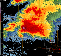
Reported tornadoes
Note: three tornadoes in Canada were rated according to the old Fujita scaleFujita scale
The Fujita scale , or Fujita-Pearson scale, is a scale for rating tornado intensity, based primarily on the damage tornadoes inflict on human-built structures and vegetation...
, but are included in the chart below using their number rated.
| CO Colorado Colorado is a U.S. state that encompasses much of the Rocky Mountains as well as the northeastern portion of the Colorado Plateau and the western edge of the Great Plains... | WY Wyoming Wyoming is a state in the mountain region of the Western United States. The western two thirds of the state is covered mostly with the mountain ranges and rangelands in the foothills of the Eastern Rocky Mountains, while the eastern third of the state is high elevation prairie known as the High... | KS Kansas Kansas is a US state located in the Midwestern United States. It is named after the Kansas River which flows through it, which in turn was named after the Kansa Native American tribe, which inhabited the area. The tribe's name is often said to mean "people of the wind" or "people of the south... | OK Oklahoma Oklahoma is a state located in the South Central region of the United States of America. With an estimated 3,751,351 residents as of the 2010 census and a land area of 68,667 square miles , Oklahoma is the 28th most populous and 20th-largest state... | SD South Dakota South Dakota is a state located in the Midwestern region of the United States. It is named after the Lakota and Dakota Sioux American Indian tribes. Once a part of Dakota Territory, South Dakota became a state on November 2, 1889. The state has an area of and an estimated population of just over... | ND North Dakota North Dakota is a state located in the Midwestern region of the United States of America, along the Canadian border. The state is bordered by Canada to the north, Minnesota to the east, South Dakota to the south and Montana to the west. North Dakota is the 19th-largest state by area in the U.S.... | TX Texas Texas is the second largest U.S. state by both area and population, and the largest state by area in the contiguous United States.The name, based on the Caddo word "Tejas" meaning "friends" or "allies", was applied by the Spanish to the Caddo themselves and to the region of their settlement in... | MN Minnesota Minnesota is a U.S. state located in the Midwestern United States. The twelfth largest state of the U.S., it is the twenty-first most populous, with 5.3 million residents. Minnesota was carved out of the eastern half of the Minnesota Territory and admitted to the Union as the thirty-second state... | ON Ontario Ontario is a province of Canada, located in east-central Canada. It is Canada's most populous province and second largest in total area. It is home to the nation's most populous city, Toronto, and the nation's capital, Ottawa.... | IA Iowa Iowa is a state located in the Midwestern United States, an area often referred to as the "American Heartland". It derives its name from the Ioway people, one of the many American Indian tribes that occupied the state at the time of European exploration. Iowa was a part of the French colony of New... | WI Wisconsin Wisconsin is a U.S. state located in the north-central United States and is part of the Midwest. It is bordered by Minnesota to the west, Iowa to the southwest, Illinois to the south, Lake Michigan to the east, Michigan to the northeast, and Lake Superior to the north. Wisconsin's capital is... | IL Illinois Illinois is the fifth-most populous state of the United States of America, and is often noted for being a microcosm of the entire country. With Chicago in the northeast, small industrial cities and great agricultural productivity in central and northern Illinois, and natural resources like coal,... | IN Indiana Indiana is a US state, admitted to the United States as the 19th on December 11, 1816. It is located in the Midwestern United States and Great Lakes Region. With 6,483,802 residents, the state is ranked 15th in population and 16th in population density. Indiana is ranked 38th in land area and is... | NM New Mexico New Mexico is a state located in the southwest and western regions of the United States. New Mexico is also usually considered one of the Mountain States. With a population density of 16 per square mile, New Mexico is the sixth-most sparsely inhabited U.S... | NE Nebraska Nebraska is a state on the Great Plains of the Midwestern United States. The state's capital is Lincoln and its largest city is Omaha, on the Missouri River.... | MO Missouri Missouri is a US state located in the Midwestern United States, bordered by Iowa, Illinois, Kentucky, Tennessee, Arkansas, Oklahoma, Kansas and Nebraska. With a 2010 population of 5,988,927, Missouri is the 18th most populous state in the nation and the fifth most populous in the Midwest. It... | OH Ohio Ohio is a Midwestern state in the United States. The 34th largest state by area in the U.S.,it is the 7th‑most populous with over 11.5 million residents, containing several major American cities and seven metropolitan areas with populations of 500,000 or more.The state's capital is Columbus... | WV West Virginia West Virginia is a state in the Appalachian and Southeastern regions of the United States, bordered by Virginia to the southeast, Kentucky to the southwest, Ohio to the northwest, Pennsylvania to the northeast and Maryland to the east... | VA Virginia The Commonwealth of Virginia , is a U.S. state on the Atlantic Coast of the Southern United States. Virginia is nicknamed the "Old Dominion" and sometimes the "Mother of Presidents" after the eight U.S. presidents born there... | MB Manitoba Manitoba is a Canadian prairie province with an area of . The province has over 110,000 lakes and has a largely continental climate because of its flat topography. Agriculture, mostly concentrated in the fertile southern and western parts of the province, is vital to the province's economy; other... | Total | |
|---|---|---|---|---|---|---|---|---|---|---|---|---|---|---|---|---|---|---|---|---|---|
| May 22 | 1 | 3 | 16 | 1 | 21 | ||||||||||||||||
| May 23 | 5 | 4 | 70 | 3 | 1 | 83 | |||||||||||||||
| May 24 | 10 | 7 | 6 | 23 | |||||||||||||||||
| May 25 | 12 | 4 | 5 | 1 | 7 | 2 | 1 | 1 | 33 | ||||||||||||
| May 26 | 4 | 3 | 2 | 9 | |||||||||||||||||
| May 27 | 3 | 1 | 1 | 5 | |||||||||||||||||
| May 28 | 1 | 3 | 4 | ||||||||||||||||||
| May 29 | 2 | 10 | 4 | 8 | 12 | 36 | |||||||||||||||
| May 30 | 3 | 5 | 6 | 2 | 2 | 18 | |||||||||||||||
| May 31 | 1 | 1 | 1 | 3 | |||||||||||||||||
| Total | 6 | 9 | 114 | 14 | 7 | 10 | 10 | 7 | 3 | 18 | 2 | 7 | 7 | 3 | 14 | 2 | 2 | 1 | 1 | 1 | 235 |
Windsor, Colorado tornado
Just before noon on May 22, a mile-wide tornado was reported near Greeley, ColoradoGreeley, Colorado
The City of Greeley is a Home Rule Municipality that is the county seat and the most populous city of Weld County, Colorado, United States. Greeley is located in the region known as Northern Colorado. Greeley is situated north-northeast of the Colorado State Capitol in Denver. According to the...
which is about one hour north of Denver. The tornado was caught on tape and golfball size hail accompanied the storm as it traveled near Interstate 25. It moved into an unusual path towards the northwest and struck the town of Windsor
Windsor, Colorado
The Town of Windsor is a Home Rule Municipality in Larimer and Weld counties in the U.S. state of Colorado. According to the 2010 Census, the population of the town was 18,644. Windsor is located in the region known as Northern Colorado. Windsor is situated north of the Colorado State Capitol in...
causing extensive damage to some buildings although lesser damage was reported to some homes according to some video footage. One person was reported killed at the Missile Silo Campground near Greeley.
About 100 homes were destroyed or damaged beyond repair with about another 500 homes suffering other forms of damage. Businesses were also damaged and trailers overturned. The tornado also caused damage to the Windmill Daycare Center where about 150 children were located but none were injured as they took cover from the storm which blew most windows of the building. The Weld County tornado was the first killer and EF3 tornado in Colorado since an EF3 hit Holly
Holly, Colorado
Holly is an historic Statutory Town in Prowers County in southeastern Colorado, United States, near the Kansas border. Located four miles from the Kansas border at an elevation of , Holly is the least elevated town in Colorado...
in Kiowa County
Kiowa County, Colorado
Kiowa County is the second least densely populated of the 64 counties of the State of Colorado of the United States. The county population was 1,622 at the 2000 census. The county seat is Eads...
near the Kansas state line. That tornado killed two as part of a similar outbreak on March 28, 2007
Late-March 2007 Tornado Outbreak
The Late-March 2007 Tornado Outbreak was a tornado outbreak that took place across the central United States. It developed in the High Plains from South Dakota to central Texas on March 28, 2007, which produced most of the tornadoes. Several more tornadoes were reported the next three days before...
. It was estimated that the May 22 storms were the state's fourth costliest disaster ever with $147 million in estimated insured damage.
Northeast Iowa supercell
Iowa
Iowa is a state located in the Midwestern United States, an area often referred to as the "American Heartland". It derives its name from the Ioway people, one of the many American Indian tribes that occupied the state at the time of European exploration. Iowa was a part of the French colony of New...
, west of Waterloo
Waterloo, Iowa
Waterloo is a city in and the county seat of Black Hawk County, Iowa, United States. As of the 2010 United States Census the population decreased by 0.5% to 68,406. Waterloo is part of the Waterloo – Cedar Falls Metropolitan Statistical Area, and is the more populous of the two...
in the late afternoon of May 25, 2008. The first tornado warning of the cell was issued at 4:22 pm CDT (2122 UTC) for the Parkersburg
Parkersburg, Iowa
Parkersburg is a city in Butler County, Iowa, United States. The population was 1,870 in the 2010 census, a decline from 1,889 in the 2000 census. Parkersburg, although not the county seat, has the highest population of all the cities in Butler County....
area, The first tornado from this cell was reported near Aplington
Aplington, Iowa
Aplington is a city in Butler County, Iowa, United States. The population was 1,054 at the 2000 census.- History :Aplington was originally Fort Aplington, a US Army outpost until the fort burnt down in 1885. By then a small town had been built nearby and, although much of the town's economy was...
in Butler County
Butler County, Iowa
-2010 census:The 2010 census recorded a population of 14,867 in the county, with a population density of . There were 6,682 housing units, of which 6,120 were occupied.-2000 census:...
at 4:48 pm CDT. It then tracked toward Parkersburg, slamming into the southern part of the community just before 5:00 pm CDT. At that time, the tornado was estimated to be about 7/10 mile (1.1 km) wide. After passing through Parkersburg, the tornado continued eastward toward New Hartford
New Hartford, Iowa
New Hartford is a city in Butler County, Iowa, United States. The population was 516 at the 2010 census. It is the hometown of U.S. Senator Chuck Grassley of Iowa.-Geography:...
, impacting a housing development near the community at 5:09 pm CDT. The tornado then passed just north of Waterloo
Waterloo, Iowa
Waterloo is a city in and the county seat of Black Hawk County, Iowa, United States. As of the 2010 United States Census the population decreased by 0.5% to 68,406. Waterloo is part of the Waterloo – Cedar Falls Metropolitan Statistical Area, and is the more populous of the two...
and Cedar Falls
Cedar Falls, Iowa
Cedar Falls is a city in Black Hawk County, Iowa, United States, and it is home to one of Iowa's three public universities, the University of Northern Iowa. The population was 39,260 in the 2010 census, an increase from the 36,145 population in the 2000 census...
and shrunk to about 1/4 mile (400 m) in width as it continued to impact rural areas. As the tornado approached Dunkerton
Dunkerton, Iowa
Dunkerton is a city in Black Hawk County, Iowa, United States. The population was 749 at the 2000 census. It is part of the Waterloo–Cedar Falls Metropolitan Statistical Area.-History:...
, it turned to the east-northeast and grew to 1.2 miles (2 km) wide. Shortly before reaching Fairbank
Fairbank, Iowa
Fairbank is a city in Buchanan and Fayette Counties in the U.S. state of Iowa. The population was 1,041 at the 2000 census.-Geography:Fairbank is located at ....
, the tornado likely dissipated, at which point it was replaced by a second tornado, about a mile and a half south of Fairbank.
Farther east, Waterloo Regional Airport
Waterloo Regional Airport
- External links :*, official site*...
reported a 93 mph (150 km/h) wind gust, and houses were destroyed just northwest of the airport. The storm passed south of Fairbank
Fairbank, Iowa
Fairbank is a city in Buchanan and Fayette Counties in the U.S. state of Iowa. The population was 1,041 at the 2000 census.-Geography:Fairbank is located at ....
where numerous farm houses were destroyed. There were more reports of destroyed houses in Dunkerton
Dunkerton, Iowa
Dunkerton is a city in Black Hawk County, Iowa, United States. The population was 749 at the 2000 census. It is part of the Waterloo–Cedar Falls Metropolitan Statistical Area.-History:...
and mobile homes were destroyed and thrown around in Hazelton. Damage was also reported near Dundee
Dundee, Iowa
Dundee is a city in Delaware County, Iowa, United States. The population was 179 at the 2000 census.-Geography:Dundee is located at along the Maquoketa River....
before the tornado dissipated. The damage may have been caused by one or multiple tornadoes. A final assessment determined that the tornado was an EF5 with estimated peak winds of about 205 miles per hour (330 km/h). Damage in the eastern part of the track was rated EF3 according to the NWS office in the Quad Cities
Quad Cities
The Quad Cities is a group of five cities straddling the Mississippi River on the Iowa–Illinois boundary. These cities, Davenport and Bettendorf and Rock Island, Moline, and East Moline , are the center of the Quad Cities Metropolitan Area, which, as of 2010, had an estimated population of...
. 288 homes in Parkersburg, 88 in New Hartford, 15 in Hazelton and another 50 in Black Hawk County were destroyed by the tornado. According to FEMA
Federal Emergency Management Agency
The Federal Emergency Management Agency is an agency of the United States Department of Homeland Security, initially created by Presidential Reorganization Plan No. 1 of 1978 and implemented by two Executive Orders...
and the Iowa Homeland Security and Emergency Management, damage was preliminary estimated at around $6 million in northern Iowa including more than $3 million in Butler County
Butler County, Iowa
-2010 census:The 2010 census recorded a population of 14,867 in the county, with a population density of . There were 6,682 housing units, of which 6,120 were occupied.-2000 census:...
alone. While the tornado was caught on tape and photographed by spotters, a surveillance camera inside a bank in Parkersburg also caught the tornado on tape as the storm passed over the building. Another surveillance camera shows the tornado ripping the roof of a home across a street before the video was lost.
Chet Culver
Chester John "Chet" Culver was the 41st Governor of Iowa, from 2007 to 2011. He was also elected as the Federal Liaison for the Democratic Governors Association for 2008-2009. He founded the Chet Culver Group, an energy sector consulting firm, in 2011.-Early life and education:Culver was born in...
declared Butler
Butler County, Iowa
-2010 census:The 2010 census recorded a population of 14,867 in the county, with a population density of . There were 6,682 housing units, of which 6,120 were occupied.-2000 census:...
and Black Hawk
Black Hawk County, Iowa
-2010 census:The 2010 census recorded a population of 131,090 in the county, with a population density of . There were 55,887 housing units, of which 52,470 were occupied.-2000 census:...
counties disaster area
Disaster area
A disaster area is a region or a locale heavily damaged by either natural hazards, such as tornadoes, hurricanes, tsunamis, floods, earthquakes, technological hazards including nuclear and radiation accidents, or sociological hazards like riots, terrorism or war. The population living there often...
s due to the extensive storm damage. The tornado was the first F5 or EF5 tornado in Iowa since one hit Jordan
Jordan, Iowa
Jordan is an unincorporated community in Boone County, Iowa, United States. As of 2000 the population was listed as 13.Jordan was hit by a massive tornado on June 13, 1976. The tornado was rated an F-5 by the National Weather Service, and the National Climate Data Center indicated that the damage...
on June 13, 1976 and the second deadliest in Iowa since official record-keeping began in 1950. The deadliest tornado
May 1968 tornado outbreak
The May 1968 tornado outbreak was a significant and deadly tornado outbreak that struck most of the central and southern United States on May 15- May 16, 1968. Producing 46 tornadoes, the outbreak killed at least 72 people including 45 in Arkansas alone. The outbreak also produced two F5s in Iowa...
affected the Charles City
Charles City, Iowa
Charles City is a city in Floyd County, Iowa, United States. The population was 7,652 at the 2010 census a decrease of 160, or 2%, from 7,812 at the 2000 census. It is the county seat of Floyd County. Charles City is a significant commercial and transportation center for the area, located on U.S...
area on May 15, 1968 and killed 13 while producing F5 damage.
On May 29, the Waterloo-Cedar Falls Courier
Courier
A courier is a person or a company who delivers messages, packages, and mail. Couriers are distinguished from ordinary mail services by features such as speed, security, tracking, signature, specialization and individualization of express services, and swift delivery times, which are optional for...
reported that lightweight debris from the Waterloo area, including photographs, check stubs, and "greeting cards and business records" from a Waterloo Walgreens
Walgreens
Walgreen Co. , doing business as Walgreens , is the largest drugstore chain in the United States of America. As of August 31st, the company operates 8,210 locations across all 50 states, the District of Columbia and Puerto Rico. Founded in Chicago, Illinois in 1901, and has since expanded...
, had been found in Prairie du Chien, Wisconsin, over 100 miles (160.9 km) away.
Minnesota tornadoes
Coon Rapids, Minnesota
As of the census of 2000, there were 61,627 people, 22,578 households, and 16,572 families residing in the city. The population density was 2,718.1 people per square mile . There were 22,828 housing units at an average density of 1,007.2 per square mile...
, and was rated EF1. It toppled trees and caused damage to several roofs in Coon Rapids before lifting off the ground 6 miles (10 km) later in Blaine
Blaine, Minnesota
As of the census of 2000, there were 44,942 people, 15,898 households, and 12,177 families residing in the city. The population density is 1,330 people per square mile . There are 16,169 housing units at an average density of 477.6 per square mile...
.
A second, more powerful tornado touched down at 4:55 pm in Lino Lakes
Lino Lakes, Minnesota
As of the census of 2000, there were 16,791 people, 4,857 households, and 4,162 families residing in the city. The population density was 595.1 people per square mile . There were 4,921 housing units at an average density of 174.4 per square mile...
. It caused some minor damage to some structures before it strengthened to an EF3 as it crossed into Washington County and into the town of Hugo
Hugo, Minnesota
As of the census of 2000, there were 6,363 people, 2,125 households, and 1,742 families residing in the city. The population density was 187.2 people per square mile . There were 2,174 housing units at an average density of 64.0 per square mile...
. Around 50 houses were destroyed and 150 damaged in Creek View Preserve and Water's Edge neighborhoods of Hugo. A two year old child was killed when he was thrown from his house, and his sister and parents were among nine people who were seriously injured. This was the first tornado fatality in Minnesota since September 16, 2006. Following the tornado up to 400 homes were evacuated because of downed power lines and gas leaks, and authorities went door to door to search for more injured. Up to 20 people had initially been unaccounted for, but all were located by later that night. A 62 year old woman died four days after the tornado when she suffered a heart attack while clearing debris from her yard. Her house was severely damaged by the tornado, and she had been treated for injuries immediately afterwards. Extensive damage occurred during this storm from hail up to the size of baseballs north of the Twin Cities. Up to 15,000 people lost power.
Non-tornadic events
Heavy rains fell throughout much of the weekend across southern Alberta with local areas reporting as much as 8 inches (203 mm) according to the Weather Network. Severals rivers experienced rapid rise of the water levels including the Elbow RiverElbow River
The Elbow River is a river located in southern Alberta, Canada. It flows from the Canadian Rockies to the city of Calgary, where it merges into the Bow River....
which threatened to overflow near the Calgary
Calgary
Calgary is a city in the Province of Alberta, Canada. It is located in the south of the province, in an area of foothills and prairie, approximately east of the front ranges of the Canadian Rockies...
area. Several areas across the province were under flood warnings.
On May 29–30, Ames, Iowa
Ames, Iowa
Ames is a city located in the central part of the U.S. state of Iowa in Story County, and approximately north of Des Moines. The U.S. Census Bureau designates that Ames, Iowa metropolitan statistical area as encompassing all of Story County, and which, when combined with the Boone, Iowa...
, was soaked with between 4 and 5 inches (127 mm) of rain on already-saturated soil, leading to much of south Ames and the campus of Iowa State University
Iowa State University
Iowa State University of Science and Technology, more commonly known as Iowa State University , is a public land-grant and space-grant research university located in Ames, Iowa, United States. Iowa State has produced astronauts, scientists, and Nobel and Pulitzer Prize winners, along with a host of...
being submerged under several feet of water, and forcing the evacuation of thousands of people. Floodwaters also closed down two major highways: U.S. Route 30
U.S. Route 30
U.S. Route 30 is an east–west main route of the system of United States Numbered Highways, with the highway traveling across the northern tier of the country. It is the third longest U.S. route, after U.S. Route 20 and U.S. Route 6. The western end of the highway is at Astoria, Oregon; the...
and U.S. Route 69
U.S. Route 69
U.S. Route 69 is a north–south United States highway. When it was first created, it was only long, but it has since been expanded into a Minnesota to Texas cross-country route. The highway's southern terminus is in Port Arthur, Texas at an intersection with State Highway 87...
. Longtime Ames residents said that the flooding was the worst to hit Ames since the Great Flood of 1993
Great Flood of 1993
The Great Mississippi and Missouri Rivers Flood of 1993 occurred in the American Midwest, along the Mississippi and Missouri rivers and their tributaries, from April to October 1993. The flood was among the most costly and devastating to ever occur in the United States, with $15 billion in damages...
.
See also
- List of F5 and EF5 tornadoes
- List of North American tornadoes and tornado outbreaks
- May 1–2, 2008 tornado outbreak
- Mid-May 2008 tornado outbreak sequenceMid-May 2008 tornado outbreak sequenceThe Mid-May 2008 tornado outbreak sequence is a series of tornado outbreaks that affected the Southern Plains, the southeastern and Middle Atlantic region of the United States. The storm has produced 147 confirmed tornadoes starting on May 7 and lasting until late on May 15. The outbreak sequence...
- Tornadoes of 2008Tornadoes of 2008This page documents the tornadoes and tornado outbreaks that occurred in 2008, primarily in the United States. Most tornadoes form in the U.S., although some events may take place internationally, particularly in parts of neighboring southern Canada during the Northern Hemisphere's summer season....
External links
- Slideshow of tornado damage in Weld County, CO (Courtesy of KCNC)
- Slideshow of aerial damage of Hugo, Minnesota tornado (Courtesy of WCCO)
- 2008 Tornado (Waterloo-Cedar Falls The Courier special section)
- Video of May 30 Kansas and Nebraska tornadoes (NBC News)
- Detailed damage survey of the Parkersburg tornado from NWS Des Moines
- Detailed analysis of the Parkersburg tornado