

Mitchell County, Kansas
Encyclopedia
Mitchell County is a county located in the U.S. state
of Kansas
. As of the 2010 census, the county population was 6,373. The largest city and county seat
is Beloit
.
, county until 1996, when voters approved the sale of alcoholic liquor by the individual drink with a 30% food sales requirement.
of 2000, there were 6,932 people, 2,850 households, and 1,863 families residing in the county. The population density
was 10 people per square mile (4/km²). There were 3,340 housing units at an average density of 5 per square mile (2/km²). The racial makeup of the county was 97.61% White
, 0.52% Black
or African American
, 0.40% Native American
, 0.30% Asian
, 0.03% Pacific Islander
, 0.23% from other races
, and 0.91% from two or more races. 0.88% of the population were Hispanic
or Latino
of any race.
There were 2,850 households out of which 27.80% had children under the age of 18 living with them, 57.30% were married couples
living together, 5.30% had a female householder with no husband present, and 34.60% were non-families. 31.20% of all households were made up of individuals and 16.20% had someone living alone who was 65 years of age or older. The average household size was 2.31 and the average family size was 2.91.
In the county the population was spread out with 24.50% under the age of 18, 8.50% from 18 to 24, 22.50% from 25 to 44, 23.10% from 45 to 64, and 21.40% who were 65 years of age or older. The median age was 41 years. For every 100 females there were 97.40 males. For every 100 females age 18 and over, there were 97.50 males.
The median income for a household in the county was $33,385, and the median income for a family was $41,899. Males had a median income of $26,478 versus $20,220 for females. The per capita income
for the county was $17,653. About 6.50% of families and 9.50% of the population were below the poverty line, including 13.50% of those under age 18 and 7.20% of those age 65 or over.
 Name and population (2004 estimate):
. The city of Beloit
is considered governmentally independent and is excluded from the census figures for the townships. In the following table, the population center is the largest city (or cities) included in that township's population total, if it is of a significant size.
Historical
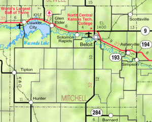
Maps
U.S. state
A U.S. state is any one of the 50 federated states of the United States of America that share sovereignty with the federal government. Because of this shared sovereignty, an American is a citizen both of the federal entity and of his or her state of domicile. Four states use the official title of...
of Kansas
Kansas
Kansas is a US state located in the Midwestern United States. It is named after the Kansas River which flows through it, which in turn was named after the Kansa Native American tribe, which inhabited the area. The tribe's name is often said to mean "people of the wind" or "people of the south...
. As of the 2010 census, the county population was 6,373. The largest city and county seat
County seat
A county seat is an administrative center, or seat of government, for a county or civil parish. The term is primarily used in the United States....
is Beloit
Beloit, Kansas
Beloit is a city in and the county seat of Mitchell County, Kansas, United States. As of the 2010 census, the city population was 3,835.- History :...
.
Law and government
Following amendment to the Kansas Constitution in 1986, the county remained a prohibition, or "dry"Dry county
A dry county is a county in the United States whose government forbids the sale of alcoholic beverages. Some prohibit off-premises sale, some prohibit on-premises sale, and some prohibit both. Hundreds of dry counties exist across the United States, almost all of them in the South...
, county until 1996, when voters approved the sale of alcoholic liquor by the individual drink with a 30% food sales requirement.
Geography
According to the 2000 census, the county has a total area of 718.62 square miles (1,861.2 km²), of which 699.82 square miles (1,812.5 km²) (or 97.38%) is land and 18.8 square miles (48.7 km²) (or 2.62%) is water.Adjacent counties
- Jewell CountyJewell County, KansasJewell County is a county located in North Central Kansas, in the Central United States. As of the 2010 census, the county population was 3,077. Its county seat and most populous city is Mankato.-19th century:...
(north) - Cloud CountyCloud County, KansasCloud County is a county located in North Central Kansas, in the Central United States. As of the 2010 census, the county population was 9,533. Its county seat and most populous city is Concordia.-19th century:...
(east) - Ottawa CountyOttawa County, KansasOttawa County is a county located in the U.S. state of Kansas. As of the 2010 census, the county population was 6,091. The largest city and county seat is Minneapolis...
(southeast) - Lincoln CountyLincoln County, KansasLincoln County is a county located in the U.S. state of Kansas. As of the 2010 census, the county population was 3,241...
(south) - Osborne CountyOsborne County, KansasOsborne County is a county located in the U.S. state of Kansas. As of the 2010 census, the county population was 3,858. The largest city and county seat is Osborne.-19th century:...
(west)
Demographics
As of the censusCensus
A census is the procedure of systematically acquiring and recording information about the members of a given population. It is a regularly occurring and official count of a particular population. The term is used mostly in connection with national population and housing censuses; other common...
of 2000, there were 6,932 people, 2,850 households, and 1,863 families residing in the county. The population density
Population density
Population density is a measurement of population per unit area or unit volume. It is frequently applied to living organisms, and particularly to humans...
was 10 people per square mile (4/km²). There were 3,340 housing units at an average density of 5 per square mile (2/km²). The racial makeup of the county was 97.61% White
Race (United States Census)
Race and ethnicity in the United States Census, as defined by the Federal Office of Management and Budget and the United States Census Bureau, are self-identification data items in which residents choose the race or races with which they most closely identify, and indicate whether or not they are...
, 0.52% Black
Race (United States Census)
Race and ethnicity in the United States Census, as defined by the Federal Office of Management and Budget and the United States Census Bureau, are self-identification data items in which residents choose the race or races with which they most closely identify, and indicate whether or not they are...
or African American
Race (United States Census)
Race and ethnicity in the United States Census, as defined by the Federal Office of Management and Budget and the United States Census Bureau, are self-identification data items in which residents choose the race or races with which they most closely identify, and indicate whether or not they are...
, 0.40% Native American
Race (United States Census)
Race and ethnicity in the United States Census, as defined by the Federal Office of Management and Budget and the United States Census Bureau, are self-identification data items in which residents choose the race or races with which they most closely identify, and indicate whether or not they are...
, 0.30% Asian
Race (United States Census)
Race and ethnicity in the United States Census, as defined by the Federal Office of Management and Budget and the United States Census Bureau, are self-identification data items in which residents choose the race or races with which they most closely identify, and indicate whether or not they are...
, 0.03% Pacific Islander
Race (United States Census)
Race and ethnicity in the United States Census, as defined by the Federal Office of Management and Budget and the United States Census Bureau, are self-identification data items in which residents choose the race or races with which they most closely identify, and indicate whether or not they are...
, 0.23% from other races
Race (United States Census)
Race and ethnicity in the United States Census, as defined by the Federal Office of Management and Budget and the United States Census Bureau, are self-identification data items in which residents choose the race or races with which they most closely identify, and indicate whether or not they are...
, and 0.91% from two or more races. 0.88% of the population were Hispanic
Race (United States Census)
Race and ethnicity in the United States Census, as defined by the Federal Office of Management and Budget and the United States Census Bureau, are self-identification data items in which residents choose the race or races with which they most closely identify, and indicate whether or not they are...
or Latino
Race (United States Census)
Race and ethnicity in the United States Census, as defined by the Federal Office of Management and Budget and the United States Census Bureau, are self-identification data items in which residents choose the race or races with which they most closely identify, and indicate whether or not they are...
of any race.
There were 2,850 households out of which 27.80% had children under the age of 18 living with them, 57.30% were married couples
Marriage
Marriage is a social union or legal contract between people that creates kinship. It is an institution in which interpersonal relationships, usually intimate and sexual, are acknowledged in a variety of ways, depending on the culture or subculture in which it is found...
living together, 5.30% had a female householder with no husband present, and 34.60% were non-families. 31.20% of all households were made up of individuals and 16.20% had someone living alone who was 65 years of age or older. The average household size was 2.31 and the average family size was 2.91.
In the county the population was spread out with 24.50% under the age of 18, 8.50% from 18 to 24, 22.50% from 25 to 44, 23.10% from 45 to 64, and 21.40% who were 65 years of age or older. The median age was 41 years. For every 100 females there were 97.40 males. For every 100 females age 18 and over, there were 97.50 males.
The median income for a household in the county was $33,385, and the median income for a family was $41,899. Males had a median income of $26,478 versus $20,220 for females. The per capita income
Per capita income
Per capita income or income per person is a measure of mean income within an economic aggregate, such as a country or city. It is calculated by taking a measure of all sources of income in the aggregate and dividing it by the total population...
for the county was $17,653. About 6.50% of families and 9.50% of the population were below the poverty line, including 13.50% of those under age 18 and 7.20% of those age 65 or over.
Incorporated cities
- BeloitBeloit, KansasBeloit is a city in and the county seat of Mitchell County, Kansas, United States. As of the 2010 census, the city population was 3,835.- History :...
, 3,781 - Cawker CityCawker City, KansasCawker City is a city in Mitchell County, Kansas, United States. As of the 2010 census, the city population was 469. The city is located along the north shore of Waconda Lake.-Geography:Cawker City is located at...
, 488 - Glen ElderGlen Elder, KansasGlen Elder is a city in Mitchell County, Kansas, United States. As of the 2010 census, the city population was 445.-Geography:Glen Elder is located at...
, 411 - TiptonTipton, KansasTipton is a city in Mitchell County, Kansas, United States. As of the 2010 census, the city population was 210.-Geography:Tipton is located at . According to the United States Census Bureau, the city has a total area of , all of it land.-Demographics:As of the census of 2000, there were 243...
, 235 - SimpsonSimpson, KansasSimpson is a city in Cloud and Mitchell counties in Kansas, United States. As of the 2010 census, the city population was 86.-Geography:Simpson is located at...
, 106, of which a small portion lies in Cloud CountyCloud County, KansasCloud County is a county located in North Central Kansas, in the Central United States. As of the 2010 census, the county population was 9,533. Its county seat and most populous city is Concordia.-19th century:... - HunterHunter, KansasHunter is a city in Mitchell County, Kansas, United States. As of the 2010 census, the city population was 57.-Geography:Hunter is located at . According to the United States Census Bureau, the city has a total area of , all of it land.-Demographics:As of the census of 2000, there were 77...
, 74 - ScottsvilleScottsville, KansasScottsville is a city in Mitchell County, Kansas, United States. As of the 2010 census, the city population was 25.-Geography:Scottsville is located at . According to the United States Census Bureau, the city has a total area of , all of it land.-Demographics:As of the census of 2000, there were...
, 20
Unincorporated places
- AshervilleAsherville, KansasAsherville is an unincorporated rural area in Mitchell County, Kansas, United States....
- Solomon RapidsSolomon Rapids, KansasSolomon Rapids is an unincorporated rural area in Mitchell County, Kansas, United States....
Townships
Mitchell County is divided into twenty townshipsCivil township
A civil township is a widely used unit of local government in the United States, subordinate to, and geographic divisions of, a county. Specific responsibilities and the degree of autonomy vary based on each state. Civil townships are distinct from survey townships, but in states that have both,...
. The city of Beloit
Beloit, Kansas
Beloit is a city in and the county seat of Mitchell County, Kansas, United States. As of the 2010 census, the city population was 3,835.- History :...
is considered governmentally independent and is excluded from the census figures for the townships. In the following table, the population center is the largest city (or cities) included in that township's population total, if it is of a significant size.
| Township | FIPS | Population center |
Population | Population density /km² (/sq mi) |
Land area km² (sq mi) | Water area km² (sq mi) | Water % | Geographic coordinates |
|---|---|---|---|---|---|---|---|---|
| Asherville | 02625 | 122 | 1 (3) | 93 (36) | 0 (0) | 0.08% | 39°25′48"N 97°59′28"W | |
| Beloit | 05800 | Beloit Beloit, Kansas Beloit is a city in and the county seat of Mitchell County, Kansas, United States. As of the 2010 census, the city population was 3,835.- History :... |
4,003 | 48 (125) | 83 (32) | 0 (0) | 0.02% | 39°26′40"N 98°5′33"W |
| Bloomfield | 07425 | 83 | 1 (2) | 94 (36) | 0 (0) | 0.24% | 39°20′33"N 98°6′24"W | |
| Blue Hill | 07575 | 36 | 0 (1) | 93 (36) | 0 (0) | 0.36% | 39°15′17"N 98°18′43"W | |
| Carr Creek | 10850 | 31 | 0 (1) | 84 (33) | 9 (3) | 9.51% | 39°26′23"N 98°26′40"W | |
| Cawker | 11150 | Cawker City Cawker City, Kansas Cawker City is a city in Mitchell County, Kansas, United States. As of the 2010 census, the city population was 469. The city is located along the north shore of Waconda Lake.-Geography:Cawker City is located at... |
578 | 8 (20) | 75 (29) | 17 (7) | 18.68% | 39°30′55"N 98°26′2"W |
| Center | 11875 | 49 | 1 (1) | 93 (36) | 0 (0) | 0.03% | 39°21′26"N 98°12′2"W | |
| Custer | 16875 | Hunter Hunter, Kansas Hunter is a city in Mitchell County, Kansas, United States. As of the 2010 census, the city population was 57.-Geography:Hunter is located at . According to the United States Census Bureau, the city has a total area of , all of it land.-Demographics:As of the census of 2000, there were 77... |
132 | 1 (4) | 94 (36) | 0 (0) | 0.13% | 39°14′56"N 98°24′53"W |
| Eureka | 21875 | 41 | 0 (1) | 93 (36) | 0 (0) | 0.38% | 39°15′20"N 97°59′46"W | |
| Glen Elder | 26525 | Glen Elder Glen Elder, Kansas Glen Elder is a city in Mitchell County, Kansas, United States. As of the 2010 census, the city population was 445.-Geography:Glen Elder is located at... |
553 | 7 (18) | 78 (30) | 15 (6) | 16.01% | 39°30′32"N 98°18′49"W |
| Hayes | 30975 | 21 | 0 (1) | 93 (36) | 0 (0) | 0.03% | 39°20′4"N 98°19′8"W | |
| Logan | 42025 | Simpson Simpson, Kansas Simpson is a city in Cloud and Mitchell counties in Kansas, United States. As of the 2010 census, the city population was 86.-Geography:Simpson is located at... |
168 | 2 (5) | 93 (36) | 0 (0) | 0.12% | 39°21′59"N 97°56′21"W |
| Lulu | 43225 | Scottsville Scottsville, Kansas Scottsville is a city in Mitchell County, Kansas, United States. As of the 2010 census, the city population was 25.-Geography:Scottsville is located at . According to the United States Census Bureau, the city has a total area of , all of it land.-Demographics:As of the census of 2000, there were... |
90 | 1 (3) | 92 (35) | 0 (0) | 0 % | 39°31′53"N 97°58′34"W |
| Pittsburg | 56050 | Tipton Tipton, Kansas Tipton is a city in Mitchell County, Kansas, United States. As of the 2010 census, the city population was 210.-Geography:Tipton is located at . According to the United States Census Bureau, the city has a total area of , all of it land.-Demographics:As of the census of 2000, there were 243... |
346 | 4 (10) | 93 (36) | 0 (0) | 0.03% | 39°20′31"N 98°28′3"W |
| Plum Creek | 56825 | 119 | 1 (3) | 92 (36) | 0 (0) | 0.02% | 39°30′53"N 98°5′21"W | |
| Round Springs | 61500 | 27 | 0 (1) | 93 (36) | 0 (0) | 0.14% | 39°15′51"N 98°11′28"W | |
| Salt Creek | 62825 | 39 | 0 (1) | 93 (36) | 0 (0) | 0.37% | 39°15′12"N 98°6′11"W | |
| Solomon Rapids | 66450 | 80 | 1 (2) | 91 (35) | 0 (0) | 0.14% | 39°31′19"N 98°12′58"W | |
| Turkey Creek | 71725 | 134 | 1 (4) | 92 (36) | 0 (0) | 0.23% | 39°26′40"N 98°12′1"W | |
| Walnut Creek | 75150 | 42 | 0 (1) | 88 (34) | 5 (2) | 5.78% | 39°26′49"N 98°19′1"W |
Unified school districts
Private schools
- St. John's Catholic High SchoolSt. John's Catholic High School (Beloit, Kansas)St. John's Catholic High School is a private, Roman Catholic high school in Beloit, Kansas. It is located in the Roman Catholic Diocese of Salina.-History:St. John High School was established in 1920. It relocated to its present location in 1952....
- Tipton Catholic High School
See also
- National Register of Historic Places listings in Mitchell County, KansasNational Register of Historic Places listings in Mitchell County, KansasThis is a list of the National Register of Historic Places listings in Mitchell County, Kansas.This is intended to be a complete list of the properties and districts on the National Register of Historic Places in Mitchell County, Kansas, United States...
Further reading
- History of the State of Kansas; William G. Cutler; A.T. Andreas Publisher; 1883. (Online HTML eBook)
- Kansas : A Cyclopedia of State History, Embracing Events, Institutions, Industries, Counties, Cities, Towns, Prominent Persons, Etc; 3 Volumes; Frank W. Blackmar; Standard Publishing Co; 944 / 955 / 824 pages; 1912. (Volume1 - Download 54MB PDF eBook),(Volume2 - Download 53MB PDF eBook), (Volume3 - Download 33MB PDF eBook)
External links
County- Mitchell County - Official Website
- Mitchell County - Directory of Public Officials
- Mitchell County - Information, Skyways
Historical
Maps
- Mitchell County Map, KDOT
- Kansas Highway Map, KDOT
- Kansas Railroad Map, KDOT
- Kansas School District Boundary Map, KSDE