

La Crosse, Kansas
Encyclopedia
La Crosse is a city in and the county seat
of Rush County
, Kansas
, United States
. As of the 2010 census, the city population was 1,342.
or La Crosse, Wisconsin
, the hometown of a local newspaper editor. La Crosse subsequently became the intended county seat, and county records were transferred there from the temporary county seat, nearby Rush Center
. A county seat war
ensued between the two communities, lasting until La Crosse was declared the permanent county seat and the construction of the county courthouse in 1888.
In the 1960s, La Crosse became a regional center of barbed wire
collecting, leading to the establishment of the Kansas Barbed Wire Museum
and the nicknaming of the city as "The Barbed Wire Capital of the World".
region of the Great Plains
approximately 12 miles (19.3 km) south of the Smoky Hill River
and 5 miles (8 km) north of Walnut Creek, a tributary of the Arkansas River
. Sand Creek, a tributary of Walnut Creek, flows southeast around the southwestern and southern portions of the city. Mule Creek, a small tributary of Sand Creek, flows southeast through the city. Located in west-central Kansas at the intersection of U.S. Route 183
and K-4
, La Crosse is 125 miles (201.2 km) northwest of Wichita
, 261 miles (420 km) west-southwest of Kansas City
, and 314 miles (505.3 km) east-southeast of Denver.
According to the United States Census Bureau
, the city has a total area of 1 square miles (2.6 km²), all of it land.
of 2000, there were 1,376 people, 585 households, and 367 families residing in the city. The population density
was 1,351.8 people per square mile (520.9/km²). There were 720 housing units at an average density of 707.4 per square mile (272.5/km²). The racial makeup of the city was 98.33% White, 0.22% African American, 0.44% Native American, 0.15% Asian, 0.22% from other races
, and 0.65% from two or more races. Hispanic or Latino of any race were 1.38% of the population.
There were 585 households out of which 26.5% had children under the age of 18 living with them, 53.0% were married couples
living together, 6.8% had a female householder with no husband present, and 37.1% were non-families. 33.5% of all households were made up of individuals and 18.3% had someone living alone who was 65 years of age or older. The average household size was 2.20 and the average family size was 2.81.
In the city the population was spread out with 21.5% under the age of 18, 6.1% from 18 to 24, 21.8% from 25 to 44, 23.3% from 45 to 64, and 27.3% who were 65 years of age or older. The median age was 45 years. For every 100 females there were 84.0 males. For every 100 females age 18 and over, there were 78.2 males.
The median income for a household in the city was $31,435, and the median income for a family was $39,118. Males had a median income of $26,118 versus $20,600 for females. The per capita income
for the city was $17,264. About 7.1% of families and 9.7% of the population were below the poverty line, including 14.1% of those under age 18 and 11.6% of those age 65 or over.
form of government. The city commission consists of the mayor
and two commissioners, and it meets on the second and fourth Wednesday of each month.
395) operates three schools in the city:
 U.S. Route 183
runs north-south through La Crosse, intersecting Kansas Highway 4 (K-4)
which runs east-west along the northern edge of the city.
Rush County Airport is located northeast of the city on the north side of K-4. Publicly owned, it has one asphalt runway and is used for general aviation
.
A line of the Kansas and Oklahoma Railroad
runs southeast-northwest through La Crosse.
FM
-Hutchinson, Kansas
television market
.
Schools
Historical
Maps
County seat
A county seat is an administrative center, or seat of government, for a county or civil parish. The term is primarily used in the United States....
of Rush County
Rush County, Kansas
Rush County is a county located in the U.S. state of Kansas. As of the 2010 census, the county population was 3,307...
, Kansas
Kansas
Kansas is a US state located in the Midwestern United States. It is named after the Kansas River which flows through it, which in turn was named after the Kansa Native American tribe, which inhabited the area. The tribe's name is often said to mean "people of the wind" or "people of the south...
, United States
United States
The United States of America is a federal constitutional republic comprising fifty states and a federal district...
. As of the 2010 census, the city population was 1,342.
History
La Crosse was founded in 1876, named after either the sportLacrosse
Lacrosse is a team sport of Native American origin played using a small rubber ball and a long-handled stick called a crosse or lacrosse stick, mainly played in the United States and Canada. It is a contact sport which requires padding. The head of the lacrosse stick is strung with loose mesh...
or La Crosse, Wisconsin
La Crosse, Wisconsin
La Crosse is a city in and the county seat of La Crosse County, Wisconsin, United States. The city lies alongside the Mississippi River.The 2011 Census Bureau estimates the city had a population of 52,485...
, the hometown of a local newspaper editor. La Crosse subsequently became the intended county seat, and county records were transferred there from the temporary county seat, nearby Rush Center
Rush Center, Kansas
Rush Center is a city in Rush County, Kansas, United States. As of the 2010 census, the city population was 170.-Geography:Rush Center is located at . According to the United States Census Bureau, the city has a total area of , all of it land.-Demographics:As of the census of 2000, there were...
. A county seat war
County seat war
A county seat war is a phenomenon that occurred in the American West as it was being settled, although incidences elsewhere, such as in West Virginia, have been also been recorded. As new towns sprang up and county lines were drawn, there was intense competition for the status and tax benefits...
ensued between the two communities, lasting until La Crosse was declared the permanent county seat and the construction of the county courthouse in 1888.
In the 1960s, La Crosse became a regional center of barbed wire
Barbed wire
Barbed wire, also known as barb wire , is a type of fencing wire constructed with sharp edges or points arranged at intervals along the strand. It is used to construct inexpensive fences and is used atop walls surrounding secured property...
collecting, leading to the establishment of the Kansas Barbed Wire Museum
Kansas Barbed Wire Museum
The Kansas Barbed Wire Museum is a barbed wire museum located in La Crosse, Kansas, USA, known as the “Barbed Wire Capital of the World.” The museum focuses on barbed wire and its history, displaying over 2,000 different forms of the wire and its history...
and the nicknaming of the city as "The Barbed Wire Capital of the World".
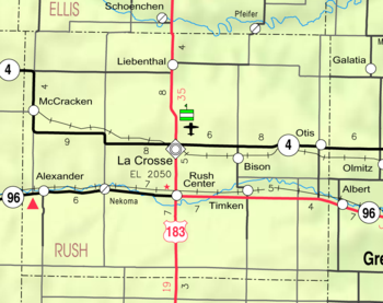
Geography
La Crosse is located at 38°31′55"N 99°18′31"W (38.532014, -99.308614) at an elevation of 2,057 feet (627 m). It lies in the Smoky HillsSmoky Hills
The Smoky Hills are an upland region of hills in the central Great Plains of North America. They are located in the central United States, encompassing north-central Kansas and a small portion of south-central Nebraska. The hills are a dissected plain covered by tallgrass and mixed-grass prairie...
region of the Great Plains
Great Plains
The Great Plains are a broad expanse of flat land, much of it covered in prairie, steppe and grassland, which lies west of the Mississippi River and east of the Rocky Mountains in the United States and Canada. This area covers parts of the U.S...
approximately 12 miles (19.3 km) south of the Smoky Hill River
Smoky Hill River
The Smoky Hill River is a river in the central Great Plains of North America, running through the U.S. states of Colorado and Kansas.-Names:The Smoky Hill gets its name from the Smoky Hills region of north-central Kansas through which it flows...
and 5 miles (8 km) north of Walnut Creek, a tributary of the Arkansas River
Arkansas River
The Arkansas River is a major tributary of the Mississippi River. The Arkansas generally flows to the east and southeast as it traverses the U.S. states of Colorado, Kansas, Oklahoma, and Arkansas. The river's initial basin starts in the Western United States in Colorado, specifically the Arkansas...
. Sand Creek, a tributary of Walnut Creek, flows southeast around the southwestern and southern portions of the city. Mule Creek, a small tributary of Sand Creek, flows southeast through the city. Located in west-central Kansas at the intersection of U.S. Route 183
U.S. Route 183
U.S. Route 183 is a north–south United States highway. U.S. 183 was the last US route to be completely paved. The 20 mile segment in Loup County, Nebraska, north of Taylor, was unpaved until 1967. The highway's northern terminus is in Presho, South Dakota, at an intersection with...
and K-4
K-4 (Kansas highway)
K-4 is the longest designated state highway in Kansas traversing from north of Scott City at US-83 to US-59 near Nortonville in northeast Kansas. A segment of the highway in McPherson County overlaps Interstate 135, and a section in Topeka runs concurrent with Interstate 70.-Western Kansas:K-4...
, La Crosse is 125 miles (201.2 km) northwest of Wichita
Wichita, Kansas
Wichita is the largest city in the U.S. state of Kansas.As of the 2010 census, the city population was 382,368. Located in south-central Kansas on the Arkansas River, Wichita is the county seat of Sedgwick County and the principal city of the Wichita metropolitan area...
, 261 miles (420 km) west-southwest of Kansas City
Kansas City, Missouri
Kansas City, Missouri is the largest city in the U.S. state of Missouri and is the anchor city of the Kansas City Metropolitan Area, the second largest metropolitan area in Missouri. It encompasses in parts of Jackson, Clay, Cass, and Platte counties...
, and 314 miles (505.3 km) east-southeast of Denver.
According to the United States Census Bureau
United States Census Bureau
The United States Census Bureau is the government agency that is responsible for the United States Census. It also gathers other national demographic and economic data...
, the city has a total area of 1 square miles (2.6 km²), all of it land.
Climate
On average in La Crosse, July is the hottest month, January is the coldest month, and May is the wettest month. The hottest temperature recorded in La Crosse was 115 °F (46 °C) in 1954; the coldest temperature recorded was -24 °F (-31 °C) in 1989.La Crosse is a city in and the county seat
County seat
A county seat is an administrative center, or seat of government, for a county or civil parish. The term is primarily used in the United States....
of Rush County
Rush County, Kansas
Rush County is a county located in the U.S. state of Kansas. As of the 2010 census, the county population was 3,307...
, Kansas
Kansas
Kansas is a US state located in the Midwestern United States. It is named after the Kansas River which flows through it, which in turn was named after the Kansa Native American tribe, which inhabited the area. The tribe's name is often said to mean "people of the wind" or "people of the south...
, United States
United States
The United States of America is a federal constitutional republic comprising fifty states and a federal district...
. As of the 2010 census, the city population was 1,342.
History
La Crosse was founded in 1876, named after either the sportLacrosse
Lacrosse is a team sport of Native American origin played using a small rubber ball and a long-handled stick called a crosse or lacrosse stick, mainly played in the United States and Canada. It is a contact sport which requires padding. The head of the lacrosse stick is strung with loose mesh...
or La Crosse, Wisconsin
La Crosse, Wisconsin
La Crosse is a city in and the county seat of La Crosse County, Wisconsin, United States. The city lies alongside the Mississippi River.The 2011 Census Bureau estimates the city had a population of 52,485...
, the hometown of a local newspaper editor. La Crosse subsequently became the intended county seat, and county records were transferred there from the temporary county seat, nearby Rush Center
Rush Center, Kansas
Rush Center is a city in Rush County, Kansas, United States. As of the 2010 census, the city population was 170.-Geography:Rush Center is located at . According to the United States Census Bureau, the city has a total area of , all of it land.-Demographics:As of the census of 2000, there were...
. A county seat war
County seat war
A county seat war is a phenomenon that occurred in the American West as it was being settled, although incidences elsewhere, such as in West Virginia, have been also been recorded. As new towns sprang up and county lines were drawn, there was intense competition for the status and tax benefits...
ensued between the two communities, lasting until La Crosse was declared the permanent county seat and the construction of the county courthouse in 1888.
In the 1960s, La Crosse became a regional center of barbed wire
Barbed wire
Barbed wire, also known as barb wire , is a type of fencing wire constructed with sharp edges or points arranged at intervals along the strand. It is used to construct inexpensive fences and is used atop walls surrounding secured property...
collecting, leading to the establishment of the Kansas Barbed Wire Museum
Kansas Barbed Wire Museum
The Kansas Barbed Wire Museum is a barbed wire museum located in La Crosse, Kansas, USA, known as the “Barbed Wire Capital of the World.” The museum focuses on barbed wire and its history, displaying over 2,000 different forms of the wire and its history...
and the nicknaming of the city as "The Barbed Wire Capital of the World".
Geography
La Crosse is located at 38°31′55"N 99°18′31"W (38.532014, -99.308614) at an elevation of 2,057 feet (627 m). It lies in the Smoky HillsSmoky Hills
The Smoky Hills are an upland region of hills in the central Great Plains of North America. They are located in the central United States, encompassing north-central Kansas and a small portion of south-central Nebraska. The hills are a dissected plain covered by tallgrass and mixed-grass prairie...
region of the Great Plains
Great Plains
The Great Plains are a broad expanse of flat land, much of it covered in prairie, steppe and grassland, which lies west of the Mississippi River and east of the Rocky Mountains in the United States and Canada. This area covers parts of the U.S...
approximately 12 miles (19.3 km) south of the Smoky Hill River
Smoky Hill River
The Smoky Hill River is a river in the central Great Plains of North America, running through the U.S. states of Colorado and Kansas.-Names:The Smoky Hill gets its name from the Smoky Hills region of north-central Kansas through which it flows...
and 5 miles (8 km) north of Walnut Creek, a tributary of the Arkansas River
Arkansas River
The Arkansas River is a major tributary of the Mississippi River. The Arkansas generally flows to the east and southeast as it traverses the U.S. states of Colorado, Kansas, Oklahoma, and Arkansas. The river's initial basin starts in the Western United States in Colorado, specifically the Arkansas...
. Sand Creek, a tributary of Walnut Creek, flows southeast around the southwestern and southern portions of the city. Mule Creek, a small tributary of Sand Creek, flows southeast through the city. Located in west-central Kansas at the intersection of U.S. Route 183
U.S. Route 183
U.S. Route 183 is a north–south United States highway. U.S. 183 was the last US route to be completely paved. The 20 mile segment in Loup County, Nebraska, north of Taylor, was unpaved until 1967. The highway's northern terminus is in Presho, South Dakota, at an intersection with...
and K-4
K-4 (Kansas highway)
K-4 is the longest designated state highway in Kansas traversing from north of Scott City at US-83 to US-59 near Nortonville in northeast Kansas. A segment of the highway in McPherson County overlaps Interstate 135, and a section in Topeka runs concurrent with Interstate 70.-Western Kansas:K-4...
, La Crosse is 125 miles (201.2 km) northwest of Wichita
Wichita, Kansas
Wichita is the largest city in the U.S. state of Kansas.As of the 2010 census, the city population was 382,368. Located in south-central Kansas on the Arkansas River, Wichita is the county seat of Sedgwick County and the principal city of the Wichita metropolitan area...
, 261 miles (420 km) west-southwest of Kansas City
Kansas City, Missouri
Kansas City, Missouri is the largest city in the U.S. state of Missouri and is the anchor city of the Kansas City Metropolitan Area, the second largest metropolitan area in Missouri. It encompasses in parts of Jackson, Clay, Cass, and Platte counties...
, and 314 miles (505.3 km) east-southeast of Denver.
According to the United States Census Bureau
United States Census Bureau
The United States Census Bureau is the government agency that is responsible for the United States Census. It also gathers other national demographic and economic data...
, the city has a total area of 1 square miles (2.6 km²), all of it land.
Climate
On average in La Crosse, July is the hottest month, January is the coldest month, and May is the wettest month. The hottest temperature recorded in La Crosse was 115 °F (46 °C) in 1954; the coldest temperature recorded was -24 °F (-31 °C) in 1989.Demographics
As of the censusCensus
A census is the procedure of systematically acquiring and recording information about the members of a given population. It is a regularly occurring and official count of a particular population. The term is used mostly in connection with national population and housing censuses; other common...
of 2000, there were 1,376 people, 585 households, and 367 families residing in the city. The population density
Population density
Population density is a measurement of population per unit area or unit volume. It is frequently applied to living organisms, and particularly to humans...
was 1,351.8 people per square mile (520.9/km²). There were 720 housing units at an average density of 707.4 per square mile (272.5/km²). The racial makeup of the city was 98.33% White, 0.22% African American, 0.44% Native American, 0.15% Asian, 0.22% from other races
Race (United States Census)
Race and ethnicity in the United States Census, as defined by the Federal Office of Management and Budget and the United States Census Bureau, are self-identification data items in which residents choose the race or races with which they most closely identify, and indicate whether or not they are...
, and 0.65% from two or more races. Hispanic or Latino of any race were 1.38% of the population.
There were 585 households out of which 26.5% had children under the age of 18 living with them, 53.0% were married couples
Marriage
Marriage is a social union or legal contract between people that creates kinship. It is an institution in which interpersonal relationships, usually intimate and sexual, are acknowledged in a variety of ways, depending on the culture or subculture in which it is found...
living together, 6.8% had a female householder with no husband present, and 37.1% were non-families. 33.5% of all households were made up of individuals and 18.3% had someone living alone who was 65 years of age or older. The average household size was 2.20 and the average family size was 2.81.
In the city the population was spread out with 21.5% under the age of 18, 6.1% from 18 to 24, 21.8% from 25 to 44, 23.3% from 45 to 64, and 27.3% who were 65 years of age or older. The median age was 45 years. For every 100 females there were 84.0 males. For every 100 females age 18 and over, there were 78.2 males.
The median income for a household in the city was $31,435, and the median income for a family was $39,118. Males had a median income of $26,118 versus $20,600 for females. The per capita income
Per capita income
Per capita income or income per person is a measure of mean income within an economic aggregate, such as a country or city. It is calculated by taking a measure of all sources of income in the aggregate and dividing it by the total population...
for the city was $17,264. About 7.1% of families and 9.7% of the population were below the poverty line, including 14.1% of those under age 18 and 11.6% of those age 65 or over.
Government
La Crosse is a city of the third class, according to state statute, with a commission-managerCouncil-manager government
The council–manager government form is one of two predominant forms of municipal government in the United States; the other common form of local government is the mayor-council government form, which characteristically occurs in large cities...
form of government. The city commission consists of the mayor
Mayor
In many countries, a Mayor is the highest ranking officer in the municipal government of a town or a large urban city....
and two commissioners, and it meets on the second and fourth Wednesday of each month.
Education
La Crosse Public Schools (USDUnified school district
A unified school district or unit school district is a school district which includes both primary school and high school under the same district control....
395) operates three schools in the city:
- La Crosse Elementary School (Grades K-6)
- La Crosse Middle School (7-8)
- La Crosse High School (9-12)
Transportation
U.S. Route 183
U.S. Route 183 is a north–south United States highway. U.S. 183 was the last US route to be completely paved. The 20 mile segment in Loup County, Nebraska, north of Taylor, was unpaved until 1967. The highway's northern terminus is in Presho, South Dakota, at an intersection with...
runs north-south through La Crosse, intersecting Kansas Highway 4 (K-4)
K-4 (Kansas highway)
K-4 is the longest designated state highway in Kansas traversing from north of Scott City at US-83 to US-59 near Nortonville in northeast Kansas. A segment of the highway in McPherson County overlaps Interstate 135, and a section in Topeka runs concurrent with Interstate 70.-Western Kansas:K-4...
which runs east-west along the northern edge of the city.
Rush County Airport is located northeast of the city on the north side of K-4. Publicly owned, it has one asphalt runway and is used for general aviation
General aviation
General aviation is one of the two categories of civil aviation. It refers to all flights other than military and scheduled airline and regular cargo flights, both private and commercial. General aviation flights range from gliders and powered parachutes to large, non-scheduled cargo jet flights...
.
A line of the Kansas and Oklahoma Railroad
Kansas and Oklahoma Railroad
The Kansas and Oklahoma Railroad is a shortline railroad operating in the western United States.The tracks Kansas and Oklahoma operate on include the Kansas City-Colorado main line formerly operated by the Missouri Pacific and later Union Pacific railways....
runs southeast-northwest through La Crosse.
Radio
The following radio stations are licensed to and/or broadcast from La Crosse:FM
| Frequency | Callsign | Format | City of License City of license A city of license or community of license, in American and Canadian broadcasting, is the community that a radio station or television station is officially licensed to serve by that country's broadcast regulator.... |
Notes |
|---|---|---|---|---|
| 93.5 | KKDT | Adult Hits Adult hits Adult hits is a radio format, popular in the early 2000s, that does not adhere to a specific music genre, but instead draws from a wider playlist... |
Burdett, Kansas Burdett, Kansas Burdett is a city in Pawnee County, Kansas, United States. As of the 2010 census, the city population was 247.-Geography:Burdett is located at . According to the United States Census Bureau, the city has a total area of , all of it land.-Demographics:As of the census of 2000, there were 256... |
Dave FM Dave FM "Dave FM" is the moniker of at least two commercial radio stations in North America:*since 2003, CJDV in Cambridge, Ontario, Canada*since 2004, WZGC in Atlanta, Georgia, USA... ; Broadcasts from La Crosse |
| 104.7 | KXNC KXNC KXNC is a radio station broadcasting a Top 40 music radio format. Licensed to Ness City, Kansas, USA, it serves the Hays, Kansas, area. The station is currently owned by Lance Sayler and programming includes the Ace & TJ Show.... |
Top 40 Contemporary hit radio Contemporary hit radio is a radio format that is common in the United States, United Kingdom, Canada and Australia that focuses on playing current and recurrent popular music as determined by the Top 40 music charts... |
Ness City, Kansas Ness City, Kansas Ness is a city in and the county seat of Ness County, Kansas, United States. As of the 2010 census, the city population was 1,449. Ness City is famous for its four-story Old Ness County Bank Building located downtown, and nicknamed Skyscraper of the Plains.-Geography:Ness City is located at... |
Broadcasts from La Crosse |
Television
La Crosse is in the WichitaWichita, Kansas
Wichita is the largest city in the U.S. state of Kansas.As of the 2010 census, the city population was 382,368. Located in south-central Kansas on the Arkansas River, Wichita is the county seat of Sedgwick County and the principal city of the Wichita metropolitan area...
-Hutchinson, Kansas
Hutchinson, Kansas
Hutchinson is the largest city in and the county seat of Reno County, Kansas, United States, northwest of Wichita, on the Arkansas River. It has been home to salt mines since 1887, thus its nickname of "Salt City", but locals call it "Hutch"...
television market
Media market
A media market, broadcast market, media region, designated market area , Television Market Area , or simply market is a region where the population can receive the same television and radio station offerings, and may also include other types of media including newspapers and Internet content...
.
Further reading
- History of the State of Kansas; William G. Cutler; A.T. Andreas Publisher; 1883. (Online HTML eBook)
- Kansas : A Cyclopedia of State History, Embracing Events, Institutions, Industries, Counties, Cities, Towns, Prominent Persons, Etc; 3 Volumes; Frank W. Blackmar; Standard Publishing Co; 944 / 955 / 824 pages; 1912. (Volume1 - Download 54MB PDF eBook),(Volume2 - Download 53MB PDF eBook), (Volume3 - Download 33MB PDF eBook)
External links
CitySchools
- USD 395, local school district
Historical
- History of Cities in Rush County
- La Crosse Info, Legends of Kansas
Maps
- La Crosse City Map, KDOT
- Rush County Map, KDOT