
Saline County, Kansas
Encyclopedia
Saline County is a county located in the U.S. state
of Kansas
. As of the 2010 census, the county population was 55,606. The largest city and county seat
is Salina
.
Saline County is part of the Salina Micropolitan Statistical Area
.
, county until the Kansas Constitution was amended in 1986 and voters approved the sale of alcoholic liquor by the individual drink with a 30% food sales requirement. The food sales requirement was removed with voter approval in 1994.
The Board of Commissioners has three members, one elected from each of the three commission districts. Commissioners are elected on a partisan basis. The districts are reapportioned every three years, with the three districts being equally populated. Term lengths are four years.
Current representatives on the Board of Commissioners are Jerry Fowler (District 3; vice chairman), Randy Duncan (District 1; secretary), and John Reynolds (District 2; chairman).
The current county administrator is Rita Deister.
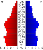
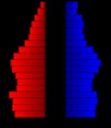
 As of the census
of 2000, there were 53,597 people, 21,436 households, and 14,212 families residing in the county. The population density
was 74 people per square mile (29/km²). There were 22,695 housing units at an average density of 32 per square mile (12/km²). The racial makeup of the county was 89.17% White
, 3.10% Black
or African American
, 0.52% Native American
, 1.70% Asian
, 0.04% Pacific Islander
, 3.33% from other races
, and 2.14% from two or more races. 6.02% of the population were Hispanic
or Latino
of any race.
There are 21,436 households in the county, out of which 32.10% have children under the age of 18 living with them, 52.90% were married couples
living together, 9.70% had a female householder with no husband present, and 33.70% were non-families. 28.30% of all households were made up of individuals and 10.70% had someone living alone who was 65 years of age or older. The average household size was 2.43 and the average family size was 2.98.
In the county the population was spread out with 26.20% under the age of 18, 9.40% from 18 to 24, 28.40% from 25 to 44, 22.10% from 45 to 64, and 14.00% who were 65 years of age or older. The median age was 36 years. For every 100 females there were 97.40 males. For every 100 females age 18 and over, there were 94.40 males.
The median income for a household in the county was $37,308, and the median income for a family was $46,362. Males had a median income of $31,509 versus $22,047 for females. The per capita income
for the county was $19,073. About 6.00% of families and 8.80% of the population were below the poverty line, including 9.60% of those under age 18 and 8.80% of those age 65 or over.
. The city of Salina
is considered governmentally independent and is excluded from the census figures for the townships. In the following table, the population center is the largest city (or cities) included in that township's population total, if it is of a significant size.
District Office In Neighboring County
Maps
U.S. state
A U.S. state is any one of the 50 federated states of the United States of America that share sovereignty with the federal government. Because of this shared sovereignty, an American is a citizen both of the federal entity and of his or her state of domicile. Four states use the official title of...
of Kansas
Kansas
Kansas is a US state located in the Midwestern United States. It is named after the Kansas River which flows through it, which in turn was named after the Kansa Native American tribe, which inhabited the area. The tribe's name is often said to mean "people of the wind" or "people of the south...
. As of the 2010 census, the county population was 55,606. The largest city and county seat
County seat
A county seat is an administrative center, or seat of government, for a county or civil parish. The term is primarily used in the United States....
is Salina
Salina, Kansas
Salina is a city in and the county seat of Saline County, Kansas, United States. As of the 2010 census, the city population was 47,707. Located in one of the world's largest wheat-producing areas, Salina is a regional trade center for north-central Kansas...
.
Saline County is part of the Salina Micropolitan Statistical Area
Salina micropolitan area
The Salina Micropolitan Statistical Area, as defined by the United States Census Bureau, is an area consisting of two counties in Kansas, anchored by the city of Salina....
.
20th century
Saline County was a prohibition, or "dry"Dry county
A dry county is a county in the United States whose government forbids the sale of alcoholic beverages. Some prohibit off-premises sale, some prohibit on-premises sale, and some prohibit both. Hundreds of dry counties exist across the United States, almost all of them in the South...
, county until the Kansas Constitution was amended in 1986 and voters approved the sale of alcoholic liquor by the individual drink with a 30% food sales requirement. The food sales requirement was removed with voter approval in 1994.
Board of Commissioners
Saline County is governed by a Board of Commissioners. The commission enacts the annual budget for the county, creates policy to be implemented by the county administrator, approves contracts, and oversees legislation relating to the health, safety, and well-being of the county's citizens.The Board of Commissioners has three members, one elected from each of the three commission districts. Commissioners are elected on a partisan basis. The districts are reapportioned every three years, with the three districts being equally populated. Term lengths are four years.
Current representatives on the Board of Commissioners are Jerry Fowler (District 3; vice chairman), Randy Duncan (District 1; secretary), and John Reynolds (District 2; chairman).
County administrator
The county administrator is hired by the Board of Commissioners and is the administrative officer for the county. The administrator is responsible for researching administrative and operational issues and then presenting suggestions for improvement in government efficiency to the Board of Commissioners and for reviewing all requests for action brought to the Board of Commissioners. The county administrator also implements policies enacted by the Board of Commissioners, prepares the annual budget, and "supervises accounts payable, payroll, human resource division and central purchasing for the county." As needed, the county administrator will represent the county on boards and commissions.The current county administrator is Rita Deister.
Geography
According to the 2000 census, the county has a total area of 721.28 square miles (1,868.1 km²), of which 719.61 square miles (1,863.8 km²) (or 99.77%) is land and 1.67 square miles (4.3 km²) (or 0.23%) is water.Adjacent counties
- Ottawa CountyOttawa County, KansasOttawa County is a county located in the U.S. state of Kansas. As of the 2010 census, the county population was 6,091. The largest city and county seat is Minneapolis...
(north) - Dickinson CountyDickinson County, KansasDickinson County is a county located in Central Kansas, in the Central United States. As of the 2010 census, the county population was 19,754. Its county seat and most populous city is Abilene. It was named in honor of Daniel S. Dickinson.-19th century:In 1887, Mr. Herington successfully got...
(east) - Marion CountyMarion County, KansasMarion County is a county located in the U.S. state of Kansas. As of the 2010 census, the county population was 12,660. The county seat is Marion...
(southeast) - McPherson CountyMcPherson County, KansasMcPherson County is a county located in the U.S. state of Kansas. As of the 2010 census, the county population was 29,180. The largest city and county seat is McPherson. The county is named for Civil War General James B. McPherson...
(south) - Ellsworth CountyEllsworth County, KansasEllsworth County is a county located in Central Kansas, in the Central United States. As of the 2010 census, the county population was 6,497. Its county seat and most populous city is Ellsworth.-19th century:...
(west) - Lincoln CountyLincoln County, KansasLincoln County is a county located in the U.S. state of Kansas. As of the 2010 census, the county population was 3,241...
(northwest)
Demographics
Census
A census is the procedure of systematically acquiring and recording information about the members of a given population. It is a regularly occurring and official count of a particular population. The term is used mostly in connection with national population and housing censuses; other common...
of 2000, there were 53,597 people, 21,436 households, and 14,212 families residing in the county. The population density
Population density
Population density is a measurement of population per unit area or unit volume. It is frequently applied to living organisms, and particularly to humans...
was 74 people per square mile (29/km²). There were 22,695 housing units at an average density of 32 per square mile (12/km²). The racial makeup of the county was 89.17% White
Race (United States Census)
Race and ethnicity in the United States Census, as defined by the Federal Office of Management and Budget and the United States Census Bureau, are self-identification data items in which residents choose the race or races with which they most closely identify, and indicate whether or not they are...
, 3.10% Black
Race (United States Census)
Race and ethnicity in the United States Census, as defined by the Federal Office of Management and Budget and the United States Census Bureau, are self-identification data items in which residents choose the race or races with which they most closely identify, and indicate whether or not they are...
or African American
Race (United States Census)
Race and ethnicity in the United States Census, as defined by the Federal Office of Management and Budget and the United States Census Bureau, are self-identification data items in which residents choose the race or races with which they most closely identify, and indicate whether or not they are...
, 0.52% Native American
Race (United States Census)
Race and ethnicity in the United States Census, as defined by the Federal Office of Management and Budget and the United States Census Bureau, are self-identification data items in which residents choose the race or races with which they most closely identify, and indicate whether or not they are...
, 1.70% Asian
Race (United States Census)
Race and ethnicity in the United States Census, as defined by the Federal Office of Management and Budget and the United States Census Bureau, are self-identification data items in which residents choose the race or races with which they most closely identify, and indicate whether or not they are...
, 0.04% Pacific Islander
Race (United States Census)
Race and ethnicity in the United States Census, as defined by the Federal Office of Management and Budget and the United States Census Bureau, are self-identification data items in which residents choose the race or races with which they most closely identify, and indicate whether or not they are...
, 3.33% from other races
Race (United States Census)
Race and ethnicity in the United States Census, as defined by the Federal Office of Management and Budget and the United States Census Bureau, are self-identification data items in which residents choose the race or races with which they most closely identify, and indicate whether or not they are...
, and 2.14% from two or more races. 6.02% of the population were Hispanic
Race (United States Census)
Race and ethnicity in the United States Census, as defined by the Federal Office of Management and Budget and the United States Census Bureau, are self-identification data items in which residents choose the race or races with which they most closely identify, and indicate whether or not they are...
or Latino
Race (United States Census)
Race and ethnicity in the United States Census, as defined by the Federal Office of Management and Budget and the United States Census Bureau, are self-identification data items in which residents choose the race or races with which they most closely identify, and indicate whether or not they are...
of any race.
There are 21,436 households in the county, out of which 32.10% have children under the age of 18 living with them, 52.90% were married couples
Marriage
Marriage is a social union or legal contract between people that creates kinship. It is an institution in which interpersonal relationships, usually intimate and sexual, are acknowledged in a variety of ways, depending on the culture or subculture in which it is found...
living together, 9.70% had a female householder with no husband present, and 33.70% were non-families. 28.30% of all households were made up of individuals and 10.70% had someone living alone who was 65 years of age or older. The average household size was 2.43 and the average family size was 2.98.
In the county the population was spread out with 26.20% under the age of 18, 9.40% from 18 to 24, 28.40% from 25 to 44, 22.10% from 45 to 64, and 14.00% who were 65 years of age or older. The median age was 36 years. For every 100 females there were 97.40 males. For every 100 females age 18 and over, there were 94.40 males.
The median income for a household in the county was $37,308, and the median income for a family was $46,362. Males had a median income of $31,509 versus $22,047 for females. The per capita income
Per capita income
Per capita income or income per person is a measure of mean income within an economic aggregate, such as a country or city. It is calculated by taking a measure of all sources of income in the aggregate and dividing it by the total population...
for the county was $19,073. About 6.00% of families and 8.80% of the population were below the poverty line, including 9.60% of those under age 18 and 8.80% of those age 65 or over.
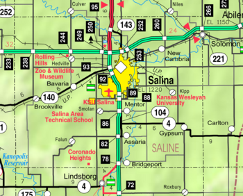
Incorporated cities
Name and population (2004 estimate):- SalinaSalina, KansasSalina is a city in and the county seat of Saline County, Kansas, United States. As of the 2010 census, the city population was 47,707. Located in one of the world's largest wheat-producing areas, Salina is a regional trade center for north-central Kansas...
, 45,988 (county seat) - SolomonSolomon, KansasSolomon is a city in Dickinson and Saline counties in the U.S. state of Kansas. As of the 2010 census, the city population was 1,095. The Saline County portion of Solomon is part of the Salina Micropolitan Statistical Area.-Geography:...
, 1,051 (of which a portion lies in Dickinson CountyDickinson County, KansasDickinson County is a county located in Central Kansas, in the Central United States. As of the 2010 census, the county population was 19,754. Its county seat and most populous city is Abilene. It was named in honor of Daniel S. Dickinson.-19th century:In 1887, Mr. Herington successfully got...
) - AssariaAssaria, KansasAssaria is a city in Saline County, Kansas, United States. As of the 2010 census, the city population was 413. It is part of the Salina Micropolitan Statistical Area.-Geography:Assaria is located at...
, 448 - GypsumGypsum, KansasGypsum is a city in Saline County, Kansas, United States. As of the 2010 census, the city population was 405. It is part of the Salina Micropolitan Statistical Area.-Geography:Gypsum is located at...
, 403 - BrookvilleBrookville, KansasBrookville is a city in Saline County, Kansas, United States. As of the 2010 census, the city population was 262. The population was higher in the turn of the 20th century and the city featured the Brookville Hotel. It is part of the Salina Micropolitan Statistical Area.-Geography:Brookville is...
, 253 - SmolanSmolan, KansasSmolan is a city in Saline County, Kansas, United States. As of the 2010 census, the city population was 215. It is part of the Salina Micropolitan Statistical Area. Smolan was named after the Swedish province of Småland, because many local settlers came from that province.-Geography:Smolan is...
, 213 - New CambriaNew Cambria, KansasNew Cambria is a city in Saline County, Kansas, United States. As of the 2010 census, the city population was 126. It is part of the Salina Micropolitan Statistical Area.-Geography:New Cambria is located at...
, 153
Unincorporated cities
- BavariaBavaria, KansasBavaria is an unincorporated community in southern Ohio Township, Saline County, Kansas, United States. It lies along K-140 and a Union Pacific Railroad line southwest of the city of Salina, the county seat of Saline County. Spring Creek flows through the community...
- BridgeportBridgeport, KansasBridgeport is an unincorporated community in southeastern Smoky View Township, Saline County, Kansas, United States. It lies along K-4 and a short distance east of Interstate 135, south of the city of Salina, the county seat of Saline County. The Smoky Hill River flows through the community. Its...
- FalunFalun, KansasFalun is an unincorporated community in southwestern Saline County, Kansas, United States. It lies southwest of the city of Salina, the county seat of Saline County. Its elevation is 1,348 feet , and it is located at . Although it is unincorporated, it has a post office, with the ZIP code...
- HedvilleHedville, KansasHedville is an unincorporated community in northern Ohio Township, Saline County, Kansas, United States. It lies along Hedville Road and a Kansas and Oklahoma Railroad line, south of Interstate 70, northwest of the city of Salina, the county seat of Saline County. Mulberry Creek flows through...
- KippKipp, KansasKipp is an unincorporated community on the border between Eureka and Solomon townships in Saline County, Kansas, United States. It lies along Schilling Road southeast of the city of Salina, the county seat of Saline County. The West Branch of Gypsum Creek flows through the community. Its...
- MentorMentor, KansasMentor is a small unincorporated town situated about 3 miles south of Salina in Saline County, Kansas, United States. As a part of Saline County, the community is part of the Salina Micropolitan Statistical Area. The town is located at and has an elevation of ....
- SalemsborgSalemsborg, KansasSalemsborg is an unincorporated community in southern Saline County, Kansas, United States. It lies at , or about 10 miles south-southwest of Salina, the county seat of Saline County....
Townships
Saline County is divided into eighteen townshipsCivil township
A civil township is a widely used unit of local government in the United States, subordinate to, and geographic divisions of, a county. Specific responsibilities and the degree of autonomy vary based on each state. Civil townships are distinct from survey townships, but in states that have both,...
. The city of Salina
Salina, Kansas
Salina is a city in and the county seat of Saline County, Kansas, United States. As of the 2010 census, the city population was 47,707. Located in one of the world's largest wheat-producing areas, Salina is a regional trade center for north-central Kansas...
is considered governmentally independent and is excluded from the census figures for the townships. In the following table, the population center is the largest city (or cities) included in that township's population total, if it is of a significant size.
| Township | FIPS | Population center |
Population | Population density /km² (/sq mi) |
Land area km² (sq mi) | Water area km² (sq mi) | Water % | Geographic coordinates |
|---|---|---|---|---|---|---|---|---|
| Cambria | 10100 | New Cambria New Cambria, Kansas New Cambria is a city in Saline County, Kansas, United States. As of the 2010 census, the city population was 126. It is part of the Salina Micropolitan Statistical Area.-Geography:New Cambria is located at... |
450 | 5 (13) | 93 (36) | 0 (0) | 0.16% | 38°54′3"N 97°31′44"W |
| Dayton | 17125 | 134 | 1 (4) | 92 (36) | 0 (0) | 0.08% | 38°55′0"N 97°25′18"W | |
| Elm Creek | 20650 | 828 | 9 (23) | 92 (36) | 0 (0) | 0.39% | 38°54′8"N 97°38′55"W | |
| Eureka | 21925 | Gypsum Gypsum, Kansas Gypsum is a city in Saline County, Kansas, United States. As of the 2010 census, the city population was 405. It is part of the Salina Micropolitan Statistical Area.-Geography:Gypsum is located at... |
664 | 7 (18) | 94 (36) | 0 (0) | 0.05% | 38°43′20"N 97°25′36"W |
| Falun | 22925 | 260 | 1 (4) | 186 (72) | 0 (0) | 0.26% | 38°39′26"N 97°47′14"W | |
| Glendale | 26475 | 104 | 1 (3) | 93 (36) | 0 (0) | 0.30% | 38°53′57"N 97°52′33"W | |
| Greeley | 28375 | 809 | 10 (26) | 79 (31) | 0 (0) | 0.09% | 38°50′21"N 97°32′35"W | |
| Gypsum | 29275 | 193 | 2 (5) | 93 (36) | 0 (0) | 0.01% | 38°39′35"N 97°25′22"W | |
| Liberty | 40350 | 183 | 2 (5) | 93 (36) | 0 (0) | 0.44% | 38°39′19"N 97°32′48"W | |
| Ohio | 52425 | 463 | 5 (13) | 94 (36) | 0 (0) | 0.13% | 38°49′12"N 97°45′9"W | |
| Pleasant Valley | 56625 | 422 | 5 (12) | 93 (36) | 0 (0) | 0.43% | 38°55′18"N 97°46′15"W | |
| Smoky Hill | 66050 | 324 | 5 (14) | 59 (23) | 0 (0) | 0.10% | 38°50′21"N 97°39′35"W | |
| Smoky View | 66075 | Assaria Assaria, Kansas Assaria is a city in Saline County, Kansas, United States. As of the 2010 census, the city population was 413. It is part of the Salina Micropolitan Statistical Area.-Geography:Assaria is located at... |
954 | 10 (27) | 93 (36) | 0 (0) | 0.06% | 38°39′25"N 97°37′34"W |
| Smolan | 66125 | 749 | 9 (23) | 85 (33) | 0 (0) | 0.15% | 38°44′24"N 97°38′26"W | |
| Solomon | 66375 | 311 | 3 (9) | 94 (36) | 0 (0) | 0.06% | 38°49′56"N 97°26′14"W | |
| Spring Creek | 67500 | Brookville Brookville, Kansas Brookville is a city in Saline County, Kansas, United States. As of the 2010 census, the city population was 262. The population was higher in the turn of the 20th century and the city featured the Brookville Hotel. It is part of the Salina Micropolitan Statistical Area.-Geography:Brookville is... |
395 | 2 (6) | 185 (72) | 1 (0) | 0.38% | 38°46′42"N 97°51′47"W |
| Walnut | 75125 | 553 | 6 (15) | 93 (36) | 1 (0) | 0.79% | 38°44′52"N 97°32′55"W | |
| Washington | 75725 | 122 | 1 (3) | 93 (36) | 0 (0) | 0.04% | 38°45′4"N 97°45′10"W |
Public schools
- USD 305, Salina
- SalinaSalina, KansasSalina is a city in and the county seat of Saline County, Kansas, United States. As of the 2010 census, the city population was 47,707. Located in one of the world's largest wheat-producing areas, Salina is a regional trade center for north-central Kansas...
, Rural Areas
- Salina
- USD 306, Southeast Of Saline
- AssariaAssaria, KansasAssaria is a city in Saline County, Kansas, United States. As of the 2010 census, the city population was 413. It is part of the Salina Micropolitan Statistical Area.-Geography:Assaria is located at...
, BridgeportBridgeport, KansasBridgeport is an unincorporated community in southeastern Smoky View Township, Saline County, Kansas, United States. It lies along K-4 and a short distance east of Interstate 135, south of the city of Salina, the county seat of Saline County. The Smoky Hill River flows through the community. Its...
, GypsumGypsum, KansasGypsum is a city in Saline County, Kansas, United States. As of the 2010 census, the city population was 405. It is part of the Salina Micropolitan Statistical Area.-Geography:Gypsum is located at...
, KippKipp, KansasKipp is an unincorporated community on the border between Eureka and Solomon townships in Saline County, Kansas, United States. It lies along Schilling Road southeast of the city of Salina, the county seat of Saline County. The West Branch of Gypsum Creek flows through the community. Its...
, MentorMentor, KansasMentor is a small unincorporated town situated about 3 miles south of Salina in Saline County, Kansas, United States. As a part of Saline County, the community is part of the Salina Micropolitan Statistical Area. The town is located at and has an elevation of ....
, Rural Areas
- Assaria
- USD 307, Ell-Saline
- BrookvilleBrookville, KansasBrookville is a city in Saline County, Kansas, United States. As of the 2010 census, the city population was 262. The population was higher in the turn of the 20th century and the city featured the Brookville Hotel. It is part of the Salina Micropolitan Statistical Area.-Geography:Brookville is...
, BavariaBavaria, KansasBavaria is an unincorporated community in southern Ohio Township, Saline County, Kansas, United States. It lies along K-140 and a Union Pacific Railroad line southwest of the city of Salina, the county seat of Saline County. Spring Creek flows through the community...
, HedvilleHedville, KansasHedville is an unincorporated community in northern Ohio Township, Saline County, Kansas, United States. It lies along Hedville Road and a Kansas and Oklahoma Railroad line, south of Interstate 70, northwest of the city of Salina, the county seat of Saline County. Mulberry Creek flows through...
, Rural Areas
- Brookville
District Office In Neighboring County
- USD 240, Twin Valley
- GlendaleGlendale, KansasGlendale is an unincorporated community in northwestern Saline County, Kansas, United States. It lies at , or about 15 miles northwest of Salina, the county seat of Saline County....
, Rural Areas
- Glendale
- USD 393, Solomon
- New CambriaNew Cambria, KansasNew Cambria is a city in Saline County, Kansas, United States. As of the 2010 census, the city population was 126. It is part of the Salina Micropolitan Statistical Area.-Geography:New Cambria is located at...
, Rural Areas
- New Cambria
- USD 400, Smoky Valley
- FalunFalun, KansasFalun is an unincorporated community in southwestern Saline County, Kansas, United States. It lies southwest of the city of Salina, the county seat of Saline County. Its elevation is 1,348 feet , and it is located at . Although it is unincorporated, it has a post office, with the ZIP code...
, SalemsborgSalemsborg, KansasSalemsborg is an unincorporated community in southern Saline County, Kansas, United States. It lies at , or about 10 miles south-southwest of Salina, the county seat of Saline County....
, SmolanSmolan, KansasSmolan is a city in Saline County, Kansas, United States. As of the 2010 census, the city population was 215. It is part of the Salina Micropolitan Statistical Area. Smolan was named after the Swedish province of Småland, because many local settlers came from that province.-Geography:Smolan is...
, Rural Areas
- Falun
Private schools
- St. John's Military SchoolSt. John's Military SchoolSt. John's Military School, located in Salina, Kansas, is a private boarding military school for male students from grades 6 to 12. It aims to develop students' academic and leadership skills in a "military environment" overseen by a President, Academic Dean and Commandant of Cadets. It has the...
- Sacred Heart High SchoolSacred Heart High School (Kansas)Sacred Heart High School is a private, Roman Catholic high school in Salina, Kansas. It is located in the Roman Catholic Diocese of Salina.-History:...
Colleges and Universities
- Brown Mackie CollegeBrown Mackie CollegeBrown Mackie College is a collection of for-profit educational institutions for career preparation in the business, legal, health sciences, information technology, and creative fields. The system of schools has locations throughout the United States. The schools are owned by Education Management...
- Kansas Wesleyan UniversityKansas Wesleyan UniversityKansas Wesleyan University is a private four-year Methodist college founded in Salina, Kansas in 1886. It is affiliated with the United Methodist Church...
- Kansas State University – Salina
- Salina Area Technical College
See also
- National Register of Historic Places listings in Saline County, KansasNational Register of Historic Places listings in Saline County, KansasThis is a list of the National Register of Historic Places listings in Saline County, Kansas.This is intended to be a complete list of the properties and districts on the National Register of Historic Places in Saline County, Kansas, United States...
Further reading
- History of the State of Kansas; William G. Cutler; A.T. Andreas Publisher; 1883. (Online HTML eBook)
- Kansas : A Cyclopedia of State History, Embracing Events, Institutions, Industries, Counties, Cities, Towns, Prominent Persons, Etc; 3 Volumes; Frank W. Blackmar; Standard Publishing Co; 944 / 955 / 824 pages; 1912. (Volume1 - Download 54MB PDF eBook), (Volume2 - Download 53MB PDF eBook), (Volume3 - Download 33MB PDF eBook)
External links
CountyMaps
- Saline County Map, KDOT
- Kansas Highway Map, KDOT
- Kansas Railroad Map, KDOT
- Kansas School District Boundary Map, KSDE
- Saline County School District Map, Saline.org