
Hancock County, Ohio
Encyclopedia
Hancock County is a county located in the state
of Ohio
, United States
. As of the 2010 census, the population was 74,782. http://quickfacts.census.gov/qfd/states/39/39063.html Its county seat
is Findlay
and was named for John Hancock
, the first signer of the Declaration of Independence
. The Hancock County area has a strong connection with the Toledo Metropolitan Area
and upon other opinions, it is sometimes considered part of the metropolitan area
.
, the county has a total area of 534 square miles (1,383.1 km²).531 square miles (1,375.3 km²) is land and 2 square miles (5.2 km²) (0.42%) is water.
of 2000, there were 71,295 people, 27,898 households, and 19,138 families residing in the county. The population density
was 134 people per square mile (52/km²). There were 29,785 housing units at an average density of 56 per square mile (22/km²). The racial makeup of the county was 95.14% White
, 1.11% Black
or African American
, 0.18% Native American
, 1.22% Asian
, 0.02% Pacific Islander
, 1.22% from other races
, and 1.12% from two or more races. 3.07% of the population were Hispanic
or Latino
of any race.
There were 27,898 households out of which 32.60% had children under the age of 18 living with them, 56.40% were married couples
living together, 8.70% had a female householder with no husband present, and 31.40% were non-families. 26.00% of all households were made up of individuals and 9.80% had someone living alone who was 65 years of age or older. The average household size was 2.49 and the average family size was 3.01.
In the county the population was spread out with 25.70% under the age of 18, 9.70% from 18 to 24, 28.70% from 25 to 44, 22.60% from 45 to 64, and 13.20% who were 65 years of age or older. The median age was 36 years. For every 100 females there were 94.30 males. For every 100 females age 18 and over, there were 91.20 males.
The median income for a household in the county was $43,856, and the median income for a family was $51,490. Males had a median income of $37,139 versus $24,374 for females. The per capita income
for the county was $20,991. About 5.20% of families and 7.50% of the population were below the poverty line, including 8.80% of those under age 18 and 6.10% of those age 65 or over.

U.S. state
A U.S. state is any one of the 50 federated states of the United States of America that share sovereignty with the federal government. Because of this shared sovereignty, an American is a citizen both of the federal entity and of his or her state of domicile. Four states use the official title of...
of Ohio
Ohio
Ohio is a Midwestern state in the United States. The 34th largest state by area in the U.S.,it is the 7th‑most populous with over 11.5 million residents, containing several major American cities and seven metropolitan areas with populations of 500,000 or more.The state's capital is Columbus...
, United States
United States
The United States of America is a federal constitutional republic comprising fifty states and a federal district...
. As of the 2010 census, the population was 74,782. http://quickfacts.census.gov/qfd/states/39/39063.html Its county seat
County seat
A county seat is an administrative center, or seat of government, for a county or civil parish. The term is primarily used in the United States....
is Findlay
Findlay, Ohio
As of the census of 2000, there were 38,967 people, 15,905 households, and 10,004 families residing in the city. The population density was 2,266.3 people per square mile . There were 17,152 housing units at an average density of 997.6 per square mile...
and was named for John Hancock
John Hancock
John Hancock was a merchant, statesman, and prominent Patriot of the American Revolution. He served as president of the Second Continental Congress and was the first and third Governor of the Commonwealth of Massachusetts...
, the first signer of the Declaration of Independence
Declaration of independence
A declaration of independence is an assertion of the independence of an aspiring state or states. Such places are usually declared from part or all of the territory of another nation or failed nation, or are breakaway territories from within the larger state...
. The Hancock County area has a strong connection with the Toledo Metropolitan Area
Toledo metropolitan area
The Toledo Metropolitan Area is a metropolitan area centered in the American city of Toledo, Ohio. As of the 2010 census, the MSA had a population of 651,429.According to the U.S...
and upon other opinions, it is sometimes considered part of the metropolitan area
Metropolitan area
The term metropolitan area refers to a region consisting of a densely populated urban core and its less-populated surrounding territories, sharing industry, infrastructure, and housing. A metropolitan area usually encompasses multiple jurisdictions and municipalities: neighborhoods, townships,...
.
Geography
According to the U.S. Census BureauUnited States Census Bureau
The United States Census Bureau is the government agency that is responsible for the United States Census. It also gathers other national demographic and economic data...
, the county has a total area of 534 square miles (1,383.1 km²).531 square miles (1,375.3 km²) is land and 2 square miles (5.2 km²) (0.42%) is water.
Adjacent counties
- Wood CountyWood County, OhioWood County is a county located in the state of Ohio, United States. As of the 2010 census, the population was 125,488. Its county seat is Bowling Green. The county was named for Captain Eleazer D. Wood, the engineer for General William Henry Harrison's army, who built Fort Meigs in the War of 1812...
(north) - Seneca CountySeneca County, OhioSeneca County is a county located in the state of Ohio, United States. As of the 2010 census, the population was 56,745. Its county seat is Tiffin and it is named for the Seneca Indians.The Tiffin Micropolitan Statistical Area includes all of Seneca County....
(northeast) - Wyandot CountyWyandot County, OhioAs of the census of 2000, there were 22,908 people, 8,882 households, and 6,270 families residing in the county. The population density was 56 people per square mile . There were 9,324 housing units at an average density of 23 per square mile...
(southeast) - Hardin CountyHardin County, OhioHardin County is a county located in the state of Ohio, United States. As of the 2010 census, the population was 32,058. Its county seat is Kenton and is named for John Hardin, an officer in the American Revolution.-Geography:According to the U.S...
(south) - Allen CountyAllen County, OhioAllen County is a county located in the U.S. state of Ohio. Its population was 106,331 as of the 2010 census. It is included in the Lima, Ohio Metropolitan Statistical Area as well as the Lima–Van Wert–Wapakoneta Combined Statistical Area....
(southwest) - Putnam CountyPutnam County, OhioPutnam County is a county located in the state of Ohio, United States. As of the 2010 census, the population was 34,499. The name is in honor of Israel Putnam, who was a hero in the French and Indian War and a general in the American Revolutionary War. Its county seat is...
(west) - Henry CountyHenry County, OhioHenry County is a county located in the state of Ohio, United States. As of the 2010 census, the population was 28,215. Its county seat is Napoleon and is named for Patrick Henry, the Virginian famous for his "give me liberty or give me death" speech....
(northwest corner)
Demographics
As of the censusCensus
A census is the procedure of systematically acquiring and recording information about the members of a given population. It is a regularly occurring and official count of a particular population. The term is used mostly in connection with national population and housing censuses; other common...
of 2000, there were 71,295 people, 27,898 households, and 19,138 families residing in the county. The population density
Population density
Population density is a measurement of population per unit area or unit volume. It is frequently applied to living organisms, and particularly to humans...
was 134 people per square mile (52/km²). There were 29,785 housing units at an average density of 56 per square mile (22/km²). The racial makeup of the county was 95.14% White
Race (United States Census)
Race and ethnicity in the United States Census, as defined by the Federal Office of Management and Budget and the United States Census Bureau, are self-identification data items in which residents choose the race or races with which they most closely identify, and indicate whether or not they are...
, 1.11% Black
Race (United States Census)
Race and ethnicity in the United States Census, as defined by the Federal Office of Management and Budget and the United States Census Bureau, are self-identification data items in which residents choose the race or races with which they most closely identify, and indicate whether or not they are...
or African American
Race (United States Census)
Race and ethnicity in the United States Census, as defined by the Federal Office of Management and Budget and the United States Census Bureau, are self-identification data items in which residents choose the race or races with which they most closely identify, and indicate whether or not they are...
, 0.18% Native American
Race (United States Census)
Race and ethnicity in the United States Census, as defined by the Federal Office of Management and Budget and the United States Census Bureau, are self-identification data items in which residents choose the race or races with which they most closely identify, and indicate whether or not they are...
, 1.22% Asian
Race (United States Census)
Race and ethnicity in the United States Census, as defined by the Federal Office of Management and Budget and the United States Census Bureau, are self-identification data items in which residents choose the race or races with which they most closely identify, and indicate whether or not they are...
, 0.02% Pacific Islander
Race (United States Census)
Race and ethnicity in the United States Census, as defined by the Federal Office of Management and Budget and the United States Census Bureau, are self-identification data items in which residents choose the race or races with which they most closely identify, and indicate whether or not they are...
, 1.22% from other races
Race (United States Census)
Race and ethnicity in the United States Census, as defined by the Federal Office of Management and Budget and the United States Census Bureau, are self-identification data items in which residents choose the race or races with which they most closely identify, and indicate whether or not they are...
, and 1.12% from two or more races. 3.07% of the population were Hispanic
Race (United States Census)
Race and ethnicity in the United States Census, as defined by the Federal Office of Management and Budget and the United States Census Bureau, are self-identification data items in which residents choose the race or races with which they most closely identify, and indicate whether or not they are...
or Latino
Race (United States Census)
Race and ethnicity in the United States Census, as defined by the Federal Office of Management and Budget and the United States Census Bureau, are self-identification data items in which residents choose the race or races with which they most closely identify, and indicate whether or not they are...
of any race.
There were 27,898 households out of which 32.60% had children under the age of 18 living with them, 56.40% were married couples
Marriage
Marriage is a social union or legal contract between people that creates kinship. It is an institution in which interpersonal relationships, usually intimate and sexual, are acknowledged in a variety of ways, depending on the culture or subculture in which it is found...
living together, 8.70% had a female householder with no husband present, and 31.40% were non-families. 26.00% of all households were made up of individuals and 9.80% had someone living alone who was 65 years of age or older. The average household size was 2.49 and the average family size was 3.01.
In the county the population was spread out with 25.70% under the age of 18, 9.70% from 18 to 24, 28.70% from 25 to 44, 22.60% from 45 to 64, and 13.20% who were 65 years of age or older. The median age was 36 years. For every 100 females there were 94.30 males. For every 100 females age 18 and over, there were 91.20 males.
The median income for a household in the county was $43,856, and the median income for a family was $51,490. Males had a median income of $37,139 versus $24,374 for females. The per capita income
Per capita income
Per capita income or income per person is a measure of mean income within an economic aggregate, such as a country or city. It is calculated by taking a measure of all sources of income in the aggregate and dividing it by the total population...
for the county was $20,991. About 5.20% of families and 7.50% of the population were below the poverty line, including 8.80% of those under age 18 and 6.10% of those age 65 or over.
History
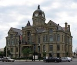
Hancock County was created on January 21, 1828, by the Ohio General Assembly from the southern portions of Wood County. Originally containing only Findlay Township, the county would add Amanda and Welfare (now Delaware) townships later in April of that year. Additional townships were laid out as follows: Jackson in 1829; Liberty and Marion in December 1830; Big Lick, Blanchard and Van Buren in 1831; Washington, Union, and Eagle in 1832; Cass and Portage in 1833; Pleasant in 1835; Orange in 1836; Madison in 1840, and finally Allen in 1850. Originally nearly 24 miles square, Hancock County would lose some of its southeast portion in 1845 to the new Wyandot County.Government
Communities
Villages
|
Mount Blanchard, Ohio Mount Blanchard is a village in Hancock County, Ohio, United States. The population was 484 at the 2000 census.-Geography:Mount Blanchard is located at .... Mount Cory, Ohio Mount Cory is a village in Hancock County, Ohio, United States. The population was 203 at the 2000 census.-Geography:Mount Cory is located at .... Rawson, Ohio Rawson is a village in Hancock County, Ohio, United States. The population was 465 at the 2000 census.Rawson was the birthplace of Cassius Jackson Keyser, an American mathematician.-Geography:Rawson is located at .... Van Buren, Ohio Van Buren is a village in Hancock County, Ohio, United States. The population was 313 at the 2000 census.-Geography:Van Buren is located at .... Vanlue, Ohio Vanlue is a village in Hancock County, Ohio, United States. The population was 371 at the 2000 census.-Geography:Vanlue is located at .... |
Townships
|
Eagle Township, Hancock County, Ohio Eagle Township is one of the seventeen townships of Hancock County, Ohio, United States. The 2000 census found 1,195 people in the township.-Geography:Located in the central part of the county, it borders the following townships:*Liberty Township - north... Jackson Township, Hancock County, Ohio Jackson Township is one of the seventeen townships of Hancock County, Ohio, United States. The 2000 census found 1,060 people in the township.-Geography:Located in the central part of the county, it borders the following townships:... Liberty Township, Hancock County, Ohio Liberty Township is one of the seventeen townships of Hancock County, Ohio, United States. The 2000 census found 6,469 people in the township.-Geography:Located in the central part of the county, it borders the following townships:... Madison Township, Hancock County, Ohio Madison Township is one of the seventeen townships of Hancock County, Ohio, United States. The 2000 census found 2,156 people in the township.-Geography:Located in the southern part of the county, it borders the following townships:... Marion Township, Hancock County, Ohio Marion Township is one of the seventeen townships of Hancock County, Ohio, United States. The 2000 census found 2,203 people in the township.-Geography:Located in the central part of the county, it borders the following townships:*Cass Township - north... Orange Township, Hancock County, Ohio Orange Township is one of the seventeen townships of Hancock County, Ohio, United States. The 2000 census found 1,290 people in the township, 1,113 of whom lived in the unincorporated portions of the township.-Geography:... |
Pleasant Township, Hancock County, Ohio Pleasant Township is one of the seventeen townships of Hancock County, Ohio, United States. The 2000 census found 2,473 people in the township, 797 of whom lived in the unincorporated portions of the township.-Geography:... Portage Township, Hancock County, Ohio Portage Township is one of the seventeen townships of Hancock County, Ohio, United States. The 2000 census found 604 people in the township.-Geography:Located in the northern part of the county, it borders the following townships:... Union Township, Hancock County, Ohio Union Township is one of the seventeen townships of Hancock County, Ohio, United States. The 2000 census found 1,726 people in the township, 1,058 of whom lived in the unincorporated portions of the township.-Geography:... Van Buren Township, Hancock County, Ohio Van Buren Township is one of the seventeen townships of Hancock County, Ohio, United States. The 2000 census found 943 people in the township, 708 of whom lived in the unincorporated portions of the township.-Geography:... Washington Township, Hancock County, Ohio Washington Township is one of the seventeen townships of Hancock County, Ohio, United States. The 2000 census found 4,602 people in the township, 1,011 of whom lived in the unincorporated portions of the township.-Geography:... |
Unincorporated communities
|
Williamstown, Ohio Williamstown is an unincorporated community in southern Madison Township, Hancock County, Ohio, United States. Although it is unincorporated, it has a post office, with the ZIP code of 45897. It lies at the intersection of U.S. Routes 30 and 68.... |