

Geology of the Iberian Peninsula
Encyclopedia
The geology of the Iberian Peninsula consists of the study of the rock formations on the Iberian Peninsula
, which includes Spain
, Portugal
, Andorra
, and Gibraltar
. The peninsula contains rocks from every age from Ediacaran
to Recent, and almost every kind of rock is represented. World class mineral deposits can also be found there.
The core of the Iberian Peninsula consists of a Hercynian craton
ic block known as the Iberian Massif. On the northeast this is bounded by The Pyrenean fold belt
, and on the southeast it is bounded by the Betic Foldchain
. These twofold chains are part of the Alpine belt
. To the west, the peninsula is delimited by the continental boundary formed by the magma
poor opening of the Atlantic Ocean
. The Hercynian Foldbelt is mostly buried by Mesozoic and Tertiary cover rocks to the east, but nevertheless outcrops through the Iberian Chain and the Catalonia
n Coastal Ranges.
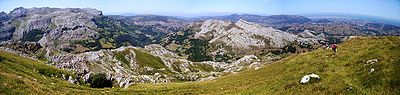
Several zones occur in the Iberian Massif. These were the pieces that were assembled to form the block. On the north coast of Spain occurs the Cantabria
n Zone. Then to the west and also in the Iberian Chain and Catalonian Coastal Ranges is the West Asturian-Leonese Zone. Then the Central Iberian Zone appears near A Coruña
, through the north of Portugal, and through the middle of Spain, including the Montes de Toledo
. The Ossa-Morena Zone outcrops out to the east of Lisbon
. This includes some Precambrian
rocks. The furthest south part is the South-Portuguese Zone.
The Variscan Orogeny occurred as the European Hunic Terrane (split off from Gondwana
) and Laurentia
-Baltica continents collided. In Iberia this occurred in pre-Stephanian Carboniferous (354–305 Ma). The external part of the orogeny was the Cantabrian Zone. This was deformed in the upper crustal layers. The West Asturian Leonese Zone and Central Iberian Zone are the external parts of the orogeny and are more deeply deformed and metamorphosed, and intruded. These three zones are part of one terrane
. The Ossa-Morena Zone and South Portuguese Zone are two different terranes that have become attached. In the Mesozoic this was mostly covered with other sediments, which have since eroded.
 The Cantabrian Zone consists of Carboniferous and older Paleozoic unmetamorphosed rocks.
It is bounded on the west and south-west sides by a concave arc of Precambrian rocks called the Narcea window, and the Villandin window in the Narcea antiform.
The Herreria Formation from the Lower Cambrian consists of shale
and feldspathic sandstone
alternating, with some conglomerate
. These have a thickness of 1 to 1.5 km.
The Lancara Formation consists of a couple of hundred meters of limestone
. The lower part was formed in peritidal zones in the Lower Cambrian, and the upper member from the Middle Cambrian contains fossils and is red or green glauconictic and nodular limestone.
The Oville Formation from Middle to Upper Cambrian contains alternating shale and sandstone. Trilobite
fossils are common in the shale.
The Barrios Formation is Arenigian and up to 500 metres (1,640.4 ft) thick. It consists of a white massive quartzite
.
The Penas
and Vidrias area, close to the western boundary of the Cantabrian zone has a complete succession of Ordovician
deposits. Black shales from Llanvirnian times are found in the Central Coal Basin eastern side. But mostly in the Ordovician Period, this zone was above water and eroding.
The Formigoso Formation dates from Middle Llandovery time in the Silurian. It consists of Monograptus
black shales and is up to 150 m thick.
The San Pedro and Furada Formations are up to 300 meters thick and consists of shale and iron bearing sandstone interbedded, These are from Wenlock
Ludlow
and Lower Gedinian times.
In the Devonian Period deposition occurred on the western side, with dolomite, argillaceous limestone
, marl
and shale from the Raneces Complex or La Vid Formation. It is 600 metres (1,968.5 ft) thick and Gedinian to Emsian in age.
The Santa Lucia Formation is of limestone. It contains coral near the Narcia Antiform in the west and has peritidal facies in the east near the Central Coal Basin. The Huergas Formation alternates between red sandstone and shale and is of Couvinian to Givetian age. The Portilla formation is of coralline limestone of Givetian to Frasnian
age. This is topped off by sandstone layers up to 500 m thick from the Frasnian to Fammenian age. Devonian sediments are not found to the east of the central coal basin, and are thickest in the west.
A pelagic facies comes from the Pisuerga-Carrion province.
In Carboniferous
times deposition started with black shales and cherts from the Tournaisian
age, and then red limestone, red shale and radiolarites were formed in the Visean
age. Mountain Limestone is a thick black lifeless limestone of Serpukhovian
age. Turbidite
s with olistoliths also appear in the Serpukhovian, indicating the first sign of the Hercynian tectonic events. These first events happened in the Pisuerga-Carrion province.
Variscan compression lifted the west side, turning a sedimentary basin into a mountain range. Over time the compressed zone moved towards the east. In the Namurian A stage, the Olleros formation was byukt from turbidites in a trough in front of the orgen, and the Barcallente formation was a carbonate platform further off shore. In the Namurian B stage the trough was forming San Emillano Formation, and the Valdeteja Formation was offshore, but in deeper marine conditions. During Westphalian A time the trough was filled and deposits of terrestrial material formed the San Emiliano Formation and Sama Group and the Lena group being thickest in the Central Coal Basin Unit. Further east in the Picos de Europa it remained covered in shallow water with continuous formation of a carbonate platform.
The Westphalian
age is represented by 5000 meters of the Central Coal Basin, which as the name suggests contains coal
. To the east this grades into the marine carbonates of the Picos de Europa. In the Pisuerga-Carrion province, there are conglomerates composed of quartzite, turbidites with slump deposits from deeper sea water. There are also some limestone layers with fossils.
The source of the Westphalian
sediments was from the west and south. These were the mountains of the Hercynian chain, formed at the same time as these deposits. During the Westphalian
the rocks in the Caqntabrian zone were folded and overthrust. The Paleozoic rocks broke off at the level of the Lancara Formation and were thrust over the top the upper layers forming nappe
s and thrust sheets. The Ponga Nappe Province is to the east of the Central Coal Basin,
Stephanian
age molasse deposits overlie the other Carboniferous rocks and are unrelated to the Hercynian orogeny. Some final folding occurred at right angles to the Westphalian structures.
Further uplift occurred, and in the Stephanian period there were some land locked basins in the mountains over the west and south nappes. But the Picos de Europa Unit was still a marine area.
In the Permian and into the Mesozoic there was extension tectonics. The Permian Autunian succession - Viñon Formation formed when basins were created by downwards normal faulting. It is mostly limestone with layers of conglomerate, shale, gypsum and alkaline volcanics. The Villaviciosa Formation from the Saxonian formed on an arid continent with sandstone and conglomerate. Conditions in the Triassic were very arid, and lagoons evaporated depositing gypsum and marl. During the Jurassic and Cretaceous Periods the zone was underwater, but most deposits from these time have been eroded away.
Another way to look at the zone is by its structure:
It consists of several thrust units: Somiedo-Correcilla, Sobia-Bodón,
Aramo, (the first to move in Early Westphalian) Central Coal Basin, Ponga (second to move) and Picos de Europa (last to move in Early Stephanian) and Pisuerga-Carrión Unit (or Palantine) (which went nowhere).
In the Late Stephanian the zone was bent around a vertical axis to make the current crescent shape. This kind of bending is called an orocline.
Two theories explain the Permian basin formation due to crustal extension, lithosphere
delamination as solid mantle sinks from the bottom of the lithosphere, being replaced by hot asthenosphere
; or a continental rift.
 The West Asturian
Leonese
Zone lies to the west and south-west of the Precambrian
rocks of the Narcea antiform, and extend east to the Precambrian rocks of the Olle de Sapo antiform. Rocks in this zone are mostly from Cambrian and Ordovician, with few from Silurian to Carboniferous. The Cambrian and Ordovician rocks were formed in shallow water in a subsiding trough. Later deposits were formed in deeper water. They have been metamorphosed to greenschist
or low grade amphibolite
. Also they mostly have a slaty cleavage
. Folds face the centre of the arc. In the west the folds are recumbent and large: Mondonedo
and Caurell folds. In the east the folds are asymmetrical. The base of the Mondonedo fold is an overthrust with the same name. Another overthrust forms the edge of this zone where it meets the Narcean Antiform. Crenulation cleavage occurs near these overthrusts. All these structures formed between Lower Devonian and Stephanian
B-C.
From the Cambrian Period, the Candana Quartzite
is equivalent to the Herreria Formation and is 1 to 2 km thick. The Vegadeo Limestone
is equivalent to the Lancara Formation and is 0.1 to 0.2 km thick. The Cabos Series is equivalent to the Oville and Barrios Formations and is 4 km thick.
Black shale
s, called the Luarca Slate
s are Llanvirnian to Llandeilian age (middle to upper Ordovician
) and are 0.5 to 1 km thick. The Agüeira Formation consists of turbidite
s of Caradocian age and is 3 km thick. Following a disconformity the Silurian
black slates are laid down 0.4 km thick.
There are few outcrops of lower Devonian rocks in the San Clodio area. And in the Carboniferous Period, this was an erosional zone forming the source of material for the Cantabrian Carboniferous deposits.
The oldest rocks are Proterozoic, metamorphosed sediments. They have been deformed by the Cadomian Orogeny
. There are volcanics and further sediments from the end of the Ediacaran
and Cambrian
periods.
Before the Carboniferous this was deformed in a north east direction with thrusts and folds.
The oldest rocks are from the Cambrian
, possibly the Precambrian
, and are orthogneiss and paragneiss. These are found near Foz do Douro
, and Miranda do Douro
. Above this are schists or shales with beds of turbidites or limestone interleaved. The stratigraphic sequence can be observed south west of Salamanca
in the Tamames Syncline, and in the Montes de Toledo
. These are followed by an unconformity. Above the unconformity can be found reddish sandstone
, shale
and conglomerate of Tremadocian age up to 1 km thick. An Arenigian age quartzite
formation is equivalent to the Amorican Quartzite. Then there is black shale or slate
matching the Luarca Slate of Llanvirn to Llandeilo Age. On top of this is the Botella or Cantera Quartzite, 0.1 km thick of Llandeilian to Caradocian Age.
Above this is a lenticular limestone called Urbana Limestone and shale and sandstone of Caradocian to Asghilian Age. Then comes the Criadero Quartzite in the Almaden area at the base of the Silurian Period. Black graptolytic shale and basic volcanic rocks overlay this.
Granite appeared with the Variscan Orogeny.
Devonian age terrigenous deposits up to 2 km thick occur in the south of the zone. There is a large amount of volcanic rock in the Almaden Syncline.
The lower Carboniferous has a flysch facies along the southern boundary of the zone, and also in the San Vitero area and around the Morais and Bragança Massifs.
 The Galicia-Trás-os-Montes Zone is a bean-shaped tectonic unit in the northwest corner of Spain and northeast Portugal (Trás-os-Montes
). It has also been called the allochthonous complexes. The zone consists of a nappe stack which is highly metamorphosed. It was formed by the collision of the Iberian Plate
with a thinned piece of crust from another continent called the Meguma terrane
. There are five units in the stack. At the lowest level are high pressure, low temperature metamorphosed rocks. Second is an ophiolite. Third is the lower part of a continental crust which has been metamorphosed to high temperature with high pressure. Fourth is a layer of sediments derived from weathering land with low-grade metamorphism. There is also an underlying Ediacaran
and early Paleozoic layer called the autochthenous sequence. Metamorphism of the allochthenous nappe occurred 390–380 Ma in the Middle Devonian. This is possibly from the Rheic Ocean. Finally, above this are other schists called the schistose domain of Galacia-Trás-os-Montes or Para-autochthenon. There are five oval shaped masses of mafic to ultramafic rocks making up the ophiolite. These are the Cabo Ortegal, Ordenes, Lalin, Bragança and Morais Massifs. Each of these are in a syncline and are surrounded by Silurian metamorphic rocks with an inward-dipping thrust zone forming the boundary. The kinds of rock in the mafic massifs are schists, gneiss
, amphibolite
, metagabbro, granulite
, eclogite
, and serpentine. The Ordenes Massif dates from 380 to 390 Ma, and represents part of the Rheno-Hercynian Ocean as part of an accretionary wedge
. It became joined to the European Hunic Terrane between the Channel Block and the allochthenous nappe. It has a corresponding block, the Lizard complex in southwest England. The Cabo Ortegal complex is dated around 345–340 Ma and is the remains of a Paleo-Tethys Ocean
mid-oceanic ridge
The Malpico-Lamigo line is a shear zone forming a line running north south on the west side of the Galicia-Trás-os-Montes Zone. It is 275 km long and associated with intrusions of granodiorite. There is over 10 km of vertical offset along the shear zone.
forming bands in two elongated anticlines between Córdoba
and Abrantes
. The Cambrian
rocks start with conglomerate
, and then have shallow water deposits and limestone
. The Ordovician Period is represented by pelitic facies. In the Late Ordovician
syenite
and alkaline granite
intrusions rose along the Córdoba Abrantes belt The Silurian
Period has volcanic rocks both acid and basic, and also pelitic deposits. The Lower Devonian was formed in shallow water. The Upper Devonian follows a break and is of flysch
.
In the Carboniferous
it starts with a turbidite
sequence containing basic volcanics. This is about 200 meters thick. Above this are coal
bearing layers. Mountain building occurred at this point. In the Westphalian
age this was deposited in lakes lying between mountain ranges. In the Stephanian
age molasse
occurs, also in basins between mountains.
The Ossa-Morena Zone was transform faulted with the Central Iberian Zone. As it slid past (200 km horizontally to the south-east and 10 km vertically), it formed the Peñarroya Basin during the late Langsettian and early Duckmantian part of Carboniferous. The basin is about 50 km long and 1 wide.
The Tomar-Badajoz-Córdoba Shear Zone (TBCZ) consists of rock that has been sheared in a ductile fashion in the left lateral direction. It is 350 km long and from 2 to 15 km wide. Granite from the Cambrian and Ordovician has turned into orthogneiss. Migmatites and metamorphosed sediments constitute the bulk of the zone. But there are also lens shaped bodies consisting of eclogite and garnet amphibolite. The shearing occurred from the end of the Devonian to Carboniferous. The zone is a suture between different terranes (CIZ and OMZ) making up the Iberian Massif.
The boundary or suture between the Ossa Morena Zone and the South Portuguese Zone is formed by an ophiolite: the Beja-Acebuches Ophiolite Complex (BAOC). This is made up of high-pressure metamorphic rocks, eclogite and blueschist. These have been thrust in the southwest direction over the top of the rock from the South Portuguese Zone.
. This continent was actually to the north of Iberia, which in turn was part of the European Hunic Terrane (EHT). At 380 Ma SPZ impacted the EHT between allochthonous units of the Galicia-Tras-Os-Montes Zone and Meseta. At about 320 Ma, the SPZ again headed south sliding past the west side of the Ossa Morena Zone.
The South Portuguese Zone now forms a thin triangle on the south end of Portugal.
Only rocks from the Upper Devonian to Carboniferous are found in the south Portuguese Zone. The Late Devonian is represented by phyllite
and quartzite
beds with graded bedding
. Volcanic rocks from Tournaisian and Lower Visean contain manganese
, zinc
and pyrite
ores. This is known as the Iberian Pyrite Belt
. This is the remains of seafloor hydrothermal vent
s. The majority of the zone is covered by Late Visean turbidite sequences several kilometres thick.
Mines in the pyrite belt area include Neves-Corvo mine
in Portugal, Rio Tinto which has been mined for 2000 years, Aguas Teñidas, Las Cruces mine, Los Frailes.
The Via Basin existed on the northeast edge in Permian times.
s were formed in the peninsula. Gabbro
appeared in northwest Galicia as Monte Castelo Gabbro, and also at Beja
in Portugal. Two different kinds of granite
occur. One comes from the middle crust and is high in felspar and low in Calcium
, and the other kind comes from the lower crust mixed with mantle magmas, and is a calcalkaline granite.
The first kind of granite is subdivided into granodiorites and muscovite
-biotite
leucogranite
. (two mica
granites). The granodiorite can be found at Finisterre, western Salamanca, Zamora, Gredos, Aracena. The two mica leucogranites can be found at Friol
, Porto-Viseu, Moncorvo-Vila Real, Vigo
, Finisterre
, Gil Ibarguchi, La Guardia
and also near Salamanca. Most of the granites are 318 Ma to 319 Ma. But some are from 340 Ma.
The calcalkaline granites were intruded at two times. The older one consists of granodiorite and adamellite with inclusions of tonalite
, diorite
, and gabbro. In western Galicia they are 316 Ma.
The younger calcalkaline granites mostly have coarse crystals, they are biotite
and horneblende granodiorites. These have intruded later than the two mica granites and are frequent in northern and central Portugal. The radiometric age is around 300 Ma. Some of the batholiths of this mixed type of granite are in Cabeza de Araya, Forgoselo, Ponferrada
and Boal
, and La Runa.
started opening around 126 Ma and completed by 85 Ma. This created the Biscay Abyssal Plain, and parted the peninsula from the Trevelyan Escarpment. During this time Iberia rotated anticlockwise relative to Eurasia. This caused the subduction of the Ligurian Basin onto the eastern side. This formed the Betic nappe stack. After 85 Ma the Atlantic Ocean opening started between Ireland
and Greenland
. This left the Bay of Biscay as a failed rift. The new Atlantic spreading caused Eurasia to rotate clockwise back towards Iberia causing underthrusting and subduction on the east side of the northern edge of Iberia, forming the Pyrenees
.
In Late Triassic
and Early Jurassic
there were two stages of rifting involving extension and subsistence on the western margin of Iberia. It also extended the western margin. The Iberian Abyssal Plain, off the west coast of Portugal and Spain, formed 126 Ma. This separated Newfoundland
's Grand Banks
, with Galica Bank and Flemish Cap being split at 118 Ma. By Early Cretaceous
, 110 Ma rifting occurs on west and north west edges.
In the Mesozoic, Late Jurassic Africa started moving east, and the Alpine Tethys opened. Subsistence related to this caused deep deposits of sediments on the east and some sediment remnants in pop downs in central parts of Spain. Two stages of rifting occurred in the east, one from Later Permian
to Triassic, and the second from Late Jurassic to early Cretaceous.
On the south side deposits of carbonates and clastic sediments formed a shelf in shallow water during late Triassic and Liassic times. This was rifted in Toarcian
times (Early Jurassic 190 Ma). Active rifting was complete by 160 Ma. After this thermal subsidence
occurred till the end of Cretaceous. During this time rifting separated North America from Africa forming a transform zone.
as a result of the Pyrenean Orogeny, part of the Alpine Chain formation. This inversion resulted in the formation of mountains called the Iberian Range. Rifting occurred at several different times in the Mezozoic repeating the same pattern of sedimentation.
Minas de Henarejos basin filled from in the Early Permian. It was a small continental basin with internal drainage.
Firstly from Late Permian to Late Triassic the Aragonese Branch sediments were deposited. These started with early layers of quartz rich sandstone derived from sedimentary and metasedimentary rocks. This first layer was 0.1 km thick. Later the deposits were derived from plutonic rocks and were feldspar rich and cemented by clay. These early deposits were alluvial and lacustrine. Finally the basin was below sea level and shallow marine carbonates were deposited followed by coastal evaporites. The thickness of these were determined by tectonic depression of the basin floor, and varies from 1 to 6 km. The names of the formations are Saxonian (Araviana Unit from the Permain), Buntsandstein (Tierga Unit, Calcena Unit, Trasobares Unit), Muschelkalk (shallow coastal marine calcareous conditions) and Keuper (evaperites). The Saxonian facies consists of sandstone over quartz conglomerate, and paleosoils. The sandstone almost entirely consists of rounded quartz grains. Rock fragments in this are shales and cherts. The grains are very compacted and cemented by quartz. The Buntsandstein contains sandstone with large crystals from plutonic rocks as well as shale and chert fragments. They are cemented by quartz, feldspar and some carbonate matrix. The presence of Potassium felspar indicates arid conditions were prevalent at the time. During the Olenekian the average temperature was in the low 30s, and the rainfall was less than 180 mm per year.
Also part of the Iberian Basin is the Castilian Branch. Formation in this are from the Permian: Boniches, Alcotas, an unconformity followed by Hoz de Gallo Conglomerate, this is capped by sandstone and silcrete at another unconformity marking the end of the Permian. Then in the Triassic was deposited the Chequilla Conglomerate, Rillo de Gallo Formation, Cañizar Sandstone Fm, Prados Fm, Eslida Fm, Marines Fm, Landete Fm, El Mas Fm, Canete Fm,
Secondly the Cameros Basin was formed and filled from Late Jurassic, Tithonian
to Berriasian
and Valanginian
to early Albian
. These are in cycles with alluvial fragments at the bottom and lake limestones and marl towards the top of each cycle. The source of the clastics was the Iberian Massif to the south west of the basin. Formations from this basin include Tera, Oncala, Urbion, Enciso, Olivan and Escucha. The sandstone in the Tithonian is mostly rounded quartz grains, but also 14% of carbonate rock fragments. Next the Berrieasian time deposits are sandstone with mostly quartz, but some albite. The quartz has 35% of polycrystalline grains. It is cemented by clay minerals. This was mainly derived from low grade metamorphic rocks of the Variscan basement. The sandstone from Valanginian is formed from windblown quartz grains. The source of the material was probably Jurassic sedimentary rocks (carbonates and shales). From Hauterivian to Albion ages the sandstones are more mixed with more feldspar. Kaolinite is frequently found filling the space between grains.
The Mesozoic basins were folded and thrust, to form the Iberian Ranges. 30 km of shortening occurred. The ranges trend north west – south east. In the northwest the ranges are buried under the Duero Basin. Sierra de Altomira is a north south oriented range separated from the Iberian Ranges by Tajo Basin. This was formed from a thrust sheet that split through evaporite beds from the Triassic.
. The peridotite had been formed from a melt, that was depleted in crustal materials, but then was re-enriched in plagioclase
felspar. The mantle exhumation occurred in two phases. First from Valanginian
to Hauterivian
(142-130 Ma) expansion happened at around 7 mm per year. Secondly from Hauterivian to Albian
(130-113 Ma) the mantle was exhumed at around 13 mm per year. After this, the asthenosphere penetrated to the surface, a mid-oceanic ridge formed and normal oceanic crust was formed. The shallower 2–3 km of peridotite has been converted to green serpentine by alteration by seawater at depth. The very surface skin (40 m thick) of the serpentine was then altered to yellow serpentine by low temperature seawater treatment.
. It is about 60 km wide and 180 km long in the northeast direction. Two high seamount
s exist: The Gettysburg Seamount has a depth of 25m, and the Ormonde Seamount is 65m below the surface. The plate boundaries here are converging at 4 mm/y, as well as sliding past each other. Upper mantle and oceanic crust are exposed along this bank. Ferrogabbro dated at 77 Ma has been intruded, Also at 66 Ma the Canary hotspot
mantle plume
passed by and caused alkaline magma to intrude. Where there is crust, it is very thin, so that the moho comes up to the sea floor. Sediment overlies the mantle, so this could be considered as crust. Since the Miocene
there has been shortening of the ocean crust absorbed by folding, and thrusting.
, the remains of a landslip from the Gorringe Bank, resulting in chaotic sediments. In most of the Tagus Plain the crust is 8 km thick, however in the north it is only 2 km thick. Northwest is the Estre Madura Spur.
. In the mid Miocene there was mountain building, then from Miocene to Pliocene there was stretching, and finally in Pleistocene the sea floor was compressed again. The gulf has mud volcano
es on the sea floor: Darwin Mud Volcano, Mercator mud volcano and Challenger Mud Volcano.
. The Galicia Bank has limestone and marl
deposited in shallow water from the Tithonian
age. This is capped by dolomite from the Berriasian
age .
From Tithonian–Berriasian the rift had shallow platforms with carbonates deposited, and sand in the depths. From Valanginian–Hauterivian carbonate cemented sediments were formed. From Valanginian
–Hauterivian
oxygen was poor, and there were six periods with no oxygen (anoxic event
s). From Turonian–Paleocene oxygen was again available and sediments were reddish or multicoloured. Some areas had strong currents. In the Paleocene dark black shales mark the lack of oxygen in stagnant water. From Thanetian
to Oligocene and through to the present day, calcareous and siliceous sediments are laid down. A strong deep water circulation started about and continues till now.
The oceanic anoxic events have been called Bonarelli event (OAE2 at ) (caused by volcanic eruptions in the Caribbean), the Mid-Cenomanian Event at and OAE 1b, OAE 1c, and OAE 1d in the Albian (around ). The carbon in the black shales appears to come from land as well as the oceans, and nitrogen fixation was also high during these periods.
and Sierra de Guadarrama
comprise the named ranges. The land was compressed and elevated as a result of the Alpine Orogeny.
The Pyrenees
were formed as the Iberia plate impacted the European plate, it was partly subducted. Initial compression started in Santonian times with the thinned crust subducted. Crust to the west was subducted later. Thrusts were formed to the south resulted in inversion of the Mesozoic basins. The Central Pyrenees had the greatest shortening, with smaller amounts to the west. Shortening continued for 40 Ma.
There are several Permian sedimentary basins, up to 1 km deep. These start with grey siltstone, coal and volcanics, and are topped with red siltstone, sandstone and conglomerate.
At the end of Cretaceous there was about 150 km separation between Iberia and France.
Gavarine Thrust Sheet
to the Cabo de la Nao.
The Betic Cordillera was formed as a result of a complex interaction of the African Plate
with Iberia. It consists of four parts, the internal Betics along the coast, the external Betics inland, the flysch units in the far south of Spain (and Gibraltar
), and the foreland basin: the Guadalquivir River Basin. Formation happened with 250 km of north south convergence from mid-Oligocene to late Miocene. From 50 km West North West convergence.
The Betics are part of the Gibraltar Arc
, which also includes the Rif in Morocco
.
During Triassic
and Jurassic
times the Betic and Maghrebian margins were opposite each other.
The Internal Betics or Alboran Crustal Domain are found along the coast. They are metamorphosed basement rocks from prior to the Miocene. Three thrusts make up these mountains (first Nevado–Filábride was buried 50 to 70 km deep, then Alpujárride, and lastly Maláguide). The crust was substantially thickened and the lower thrust was high pressure metamorphosed. Within the Internal Betics there are many depressions that have created basins that have filled with sediments. They are called the Betic Neogene Basins, and some are forming even now.
The Maláguide thrust sheet contains rocks from Silurian to Oligocene. Although the Silurian rocks were deformed in the Variscan Orogeny, the rocks in this sheet have only low grade metamorphism. It can be found north and east of Málaga and in a strip along the border between the internal and external Betics. The rocks in the Maláguide thrust sheet include phyllite, metagreywacke, limestone, metacomglomerate. The Devonian and Early Carboniferous is represented by gray slates and conglomerate, with smaller amounts of limestone, chert, and radiolarite
. There are some Permian to Triassic red beds, starting with conglomerate and thinning to sandstone and lutite
.
The Alpujárride Thrust Sheet spreads from western Málaga province to Cartagena in the east. This layer has been more metamorphosed than the Maláguide thrust sheet. It was buried from 35 to 50 km deep. At its base is mica schist, with some gneiss and migmatite
formed from sediments older than the Permian. Above this is a bluish grey schist from the Permain, and the next layer is carbonate from the Middle to Late Triassic. Above this is a black mica schist, and the top layers are a brown coloured metapelite and a quartzite.
The Triassic Mesozoic to Miocene deposits form the External Betics. Subbetic zone with deeper water deposits is in the southeast and the Prebetic zone to the northwest contains shallow water deposits. The Campo de Gibraltar
Unit is a prism accreted from terrigenous deposits formed in the Oligocene.
The Fortuna Basin makes up the Eastern Betics. It is from Tortonian to Pliocene (younger than 11.6 Ma). The basin floor subsided rapidly at first. It started filling with marine sediments as it was connected with the Mediterranean Sea. Later it became isolated and evaporites started to appear. These were then covered with continental sediments by late Tortonian 7.2 Ma. The basin became isolated as the edges were tectonically raised. During the Messinian to lower Pliocene 7.2–3.6 Ma the basin floor was lowered another 1 km and continental sediments filled it. During the Pliocene the basin was compressed, sheared and uplifted.
Ronda Peridotites outcrop in the western Internal Betics in the Alpujárride thrust sheet. These have been partly serpentonized. The variety of peridotite is lherzolite
. These were intruded at a pressure of 1 gigapascal (GPa). Beneath the Ronda Peridotites is an eclogite
formed at a pressure of 1.5 GPa. Two massifs, Sierra Bermeja and Sierra Alpujata have been rotated by 40° to the west since their solidification, as has the western External Betics.
The Nevado–Filábride Thrust Sheet was buried 50 to 70 km deep. It contains rocks originally from the Paleozoic to the Cretaceous. It has undergone high pressure low temperature metamorphism. It consists of three units. The Ragua Unit consists of albite and graphite containing mica schist, and quartzite. The Calar Alto Unit has choritoid and graphite containing mica schist, from the Paleozoic, light coloured Permo-Triassic schist, and marble from the Triassic, which have been metamorphosed to upper greenschist level at up to 450 °C. The Bédar-Macael Unit was metamorphosed to the amphibolite level, and contains marble, serpentinite, and tourmaline gneiss, as well as the more common schist. This unit was heated to 550 °C.
At the west end of the Betics lies the Guadalquivir Basin. It unconformably overlies the South Portugal Zone, Ossa Morena Zone and Central Iberian Zone. It contains Neogene to Quaternary aged material.
The Betics were compressed about 300 km in the Tertiary.
In Late Miocene a sill (land bridge) formed in the Gibraltar arc, disconnecting the Mediterranean from the Atlantic Ocean several times. This caused the evaporation of the Mediterranean Sea.
The Rock of Gibraltar
is a monolithic limestone promontory. The rock was created during the Jurassic period some 200 million years ago and uplifted during the Betic Orogeny.
. So far 8 km of sediments have accumulated. The Alboran sea has numerous areas on its floor formed from volcanic flows. This includes the Alboran Island halfway across the sea. During the Pliocene and Pleistocene volcanism continued.
in Spain, along the coast of Murcia
through the Betic range, across the Alboran Sea
to the Tidiquin Mountains in Morocco
. This zone shows itself with earthquakes. The south east side is moving north east, and the north west side is moving south west.
Majorca:
Minorca:
The southern margin consists of a narrow shelf where carbonates are deposited. Sediments spill over the ledge. South of Cabrera Island between Formentera and Cabrera islands is a small volcanic province with a few dozen outlets. The slope to the south of the shelf is the Emile-Baudot escarpment. It only has one Canyon, the Menorca Canyon, with Menorca Fan at its base. The crust in the Balearic Promontory is 25 km thick. The lithosphere is only 30 km and there is a low seismic velocity asthenosphere below.
In Menorca there are extensive outcrops of the Variscan basement. In the Triassic deposits similar to those in Germany were formed. In the early Jurassic it was covered with shallow sea water and limestone formed. From Middle to Late in the Jurassic marl and limestone formed in deep water. In the Cretaceous marl and shallow water limestone was formed. From the Late Cretaceous to the Paleogene there were few deposits. From the Eocene there is some shallow water limestone in the southeast. During the Eocene to early Oligocene, the island of Sardinia
was located northeast of the Balearic Promontory (Menorca). Sardinbia and Corsica rotated away from 19 to 15 Ma. From the Oligocene there is some conglomerate.
In the Neogene orogeny (mountain building) started again. As the ground was deformed conglomerate, calcareous sandstone, limestone, and calcareous turbidites appeared. During the orogeny from Late Oligocene to Middle Miocene the ground was shortened (compressed) by 50%. On the southeast of Majorca overturned folds were produced in the Late Oligocene to Langhian. In the Middle and Late Miocene (mostly Serravallian) the ground was stretched (extended) and faults formed and created basins. In the Late Miocene they filled with water and sediment. After the orogen, limestone marl and calcareous sandstone were added. Later in the Pliocene till now contraction has taken place again.
From the Early Miocene there are two volcanoes of calc-alkaline volcanics.
South of the Balearics there is the Algerian Basin floored by oceanic style crust from 4 to 6 km and a moho less than 15 km deep. The floor of this basin is 0.5 km of Pliocene to Quaternary sediments overlying the Messinian evaporites 1.2 km thick, which from diapirs into the sediments.
, starting at the very end of Cretaceous
and into early Eocene
. The subduction ceased at 54 Ma.
Stress from the northeast edge of Spain's collision with Eurasia affected the interior, raising the Iberian Basin to form the Iberian Chain mountain range, north east of the centre. The Azores-Gibraltar transform zone activated at about 30 Ma. This zone appears as a ridge on the Atlantic Ocean floor, and is apparent even today as an earthquake zone. Africa moved eastwards with respect to Iberia and Eurasia. This opened up the Valencia Trough and the Balearic Basin. Extension in this south east side of Iberia spread from southern France. The spreading reached and formed the Alborian Basin between 23 and 20 Ma.
Africa converged towards Eurasia, and the direction changed from north north west to north west in the Tortonian
. This change in compression formed the Baetic Cordillera
on the Mediterranean coast in the Middle Miocene
. Basins were inverted and raised up in the Iberian Central System, and also the Alboran Basin. The crust still continues to fold in these areas since the Pliocene
. Some coastal areas have been uplifted hundreds of meters in the Pliocene. Also new shear zones appeared in the Alboran Basin.
The Ninyerola Gypsum unit is fifteen kilometres south of Valencia. It consists of layers of gypsum and marl and limestone. Nodules of gypsum from this formation have been used as alabaster for carving sculptures. This was deposited from a fresh water lake, high in sulphates but low in chlorides.
The Duero Basin is the largest Tertiary basin in Iberia. It is in northwest Spain. Oligocene and Miocene continental deposits are up to 2.5 km thick. It is bounded by the central system to the south, the Iberian range to the east, and the Cantabrian Mountains to the northeast. The Cantabrian Mountains are the main source of the sediments in this basin. The Duero River started to drain the basin 9.6 Ma by connecting it the Atlantic Ocean. Gold was mined in Roman times in the basin. Las Medulas is the most famous mine. Greasy wool was used to trap gold flakes washing past from the alluvial deposits. North of Ribón is another 2000 year old gold mine.
Two Eocene basins in Portugal are the Mondego and Lower Tagus basins which are elongated in the southwest direction. Simultaneous with the formation of these grabens the Algarve basin was uplifted. In the Miocene the Lusitanean Basin was compressed, and the Portuguese Central Range and Western Mountains was formed. These too trend south west. The mountains also form piedmont or fore-deep basins. Faults developed aligned south south west. These faults developed some pull apart basins.
In the Late Pliocene (2.6 Ma) there was increased uplifting and previously deposited sediments were incised by erosion. The coast of Portugal has been rising at about 0.1 mm per year since then.
to the Atlantic past Lisbon
.
The As Pontes Basin in the far northwest of Iberia filled with alluvium and lacustrine deposits from late Oligocene to early Miocene.
. The mountains have a north east – south west trend, at an oblique angle to the original basin.
The Levante field is at the south west end of the Valencia trough. Volcanoes are from 8 to 1 Ma. The north east volcanic province at the east end of the Pyrenees, dates from 14 Ma to 11,000 years ago. Volcanoes first formed in the Empordà Basin, then in the La Selva Basin and finally in the Cerdanya Basin. Almeria and Murcia have alkaline volcanoes .
, and the Balearic Islands
. This is a northeast to southwest oriented depression between the continental slope of the Iberian Peninsula and the slope off the shelf around the Balearic Islands. This originally opened between Late Oligocene
and early Miocene
, at the same time as the Provençal Basin. The continental shelf off the Catalan
coast is from six to 30 km wide. Several V-shaped canyons cut deeply into the shelf. These are in part Foix, Besós, Arenys, La Fonda, and Creus Canyons. The Ebro margin, a shallow coastal shelf, is fed by the Ebro River, The shelf here is 70 km wide. The shelves on the Balearic margin are under 20 km wide and have a low influx of sediments, and instead are dominated by carbonates.
At the base of the Valencia Trough is the Valencia Channel, This is a gully that carries sediment to the north east to the Provençal Basin.
The Valencia trough consists of extended continental crust. At the deepest point the Moho
is only 8 km deep, whereas under the mainland it is 32 km down. Beneath the Balearics the depth is back up to 23–25 km. Other points under the Valencia Trough axis have a Moho at 15 to 10 km down. The lithosphere is only 50 to 80 km thick, and the mantle has an abnormally low speed of sound. The Crust in the trough went through a similar history to that of the mainland. It was compressed in the Variscan Orogeny, extended in the Mesozoic so that basins filled with sediment, compressed back and lifted up in the Cretaceous, then eroded. In the Eocene and late Oligocene there were a couple of basins filled with terrestrial deposits.
In the uppermost Oligocene and lower Miocene rifting started, and continental deposits were made followed by marine deposits on a shallow shelf. During this period the trough grew by extension to its present dimensions. In the middle and Upper Miocene clastic sediments were deposited under sea water. Then the level of the Mediterranean drastically dropped due to evaporation. Gullies were cut deeply into the sediments, and Messinian Salt was encrusted onto the deeper parts. In the Pliocene and Holocene deltas were formed over the shallow parts and deep sea fans in the deeper parts.
The slopes around the trough have been affected by many underwater landslides. Mostly these are small, under 100 km2 in area.
The Big'95 debris flow, is a large landslide off the coast from Castello
, beyond the Columbretes Islands
. This slide covers 2200 km2, containing 26 km3, or 50 gigatonnes of sediment. It is 110 km long, has an average thickness of 13 m, ranging from 600 m, to 1800 m below sea level. A carbon 14 date indicates the slide occurred before 9500 BC. It is believed to have been triggered by a volcanic dome, the same one that raised the Columbretes Islands above sea level.
. A large undersea slip deposit of unknown origin called the Balearic megaturbidite
covers 77,000 km2, and contains 600 km3 of sediment, at 10 m thick. The slip happened at the last low stand
.
. It has an area of 76,620 square meters, with dimensions of 245 by 520 meters.
in Cuenca
Spain. The original animal was 6 meters long, had a hump and had feathers. The fossil dates from the Barremian stage of the Late Cretaceous and is called Concavenator corcovatus. Turiasaurus
riodevensis, a truly giant dinosaur that lived between the Upper Jurassic-Lower Cretacic, was also found in Riodeva
in Teruel
Spain. The animal was 37 meters long and weighed 40-48 tons.
The Crustal depth in the Iberian Massif is 30 to 35 km.
Western Betics have crust 39 km thick and in three layers.
Eastern Betics have a crust of 23 km thick in two layers.
Along the coast crust is 23 to 25 km.
Betic lithosphere is 100 to 110 km thick.
Under the Alboran Sea the crust is 16 km thick.
Alboran lithosphere is 40 km thick.
The Tajo and Duero basins are elevated and yet show a negative Bouguer anomaly
. This is likely due to a less dense crust. In the Ossa Moena zone and South Portuguese Zone there is a positive Bouguer anomaly, due to higher crustal density. Along the Mediterranean Coast there is a positive Bouguer anomaly due to lithosphere thinned to less than 75 km.
GPS stations measure the slow movements due to continental drift and tectonic movements:
Heat flow 60–70 mW/m2 on Iberian Massif and in the Betics with 100–120 mW/m2 in the Alboran Sea where the lithosphere is thinner. A low heat flow of 40 mW/m2 is in the far south of Portugal.
is found in Spain.
visited Spain in the summer of 1830 and also in the winter of 1853. Lyell's visit to the Pyrenees led him to study the orogeny that produced the mountain chain. He discovered that they had formed over a long period of time
, and not the result of a single large catastrophe
, as was previously believed. This led to Lyell's concept of geological history being developed. His book Elements of Geology from 1830 to 1833, was translated into Spanish by Ezquerra del Bayo in 1847. This was used as a textbook, as it was the first modern geology text available for the general public in Spain. This spread Lyell's ideas and terminology.
Ezquerra del Bayo created the first geological map of Spain in 1850
Iberian Peninsula
The Iberian Peninsula , sometimes called Iberia, is located in the extreme southwest of Europe and includes the modern-day sovereign states of Spain, Portugal and Andorra, as well as the British Overseas Territory of Gibraltar...
, which includes Spain
Spain
Spain , officially the Kingdom of Spain languages]] under the European Charter for Regional or Minority Languages. In each of these, Spain's official name is as follows:;;;;;;), is a country and member state of the European Union located in southwestern Europe on the Iberian Peninsula...
, Portugal
Portugal
Portugal , officially the Portuguese Republic is a country situated in southwestern Europe on the Iberian Peninsula. Portugal is the westernmost country of Europe, and is bordered by the Atlantic Ocean to the West and South and by Spain to the North and East. The Atlantic archipelagos of the...
, Andorra
Andorra
Andorra , officially the Principality of Andorra , also called the Principality of the Valleys of Andorra, , is a small landlocked country in southwestern Europe, located in the eastern Pyrenees mountains and bordered by Spain and France. It is the sixth smallest nation in Europe having an area of...
, and Gibraltar
Gibraltar
Gibraltar is a British overseas territory located on the southern end of the Iberian Peninsula at the entrance of the Mediterranean. A peninsula with an area of , it has a northern border with Andalusia, Spain. The Rock of Gibraltar is the major landmark of the region...
. The peninsula contains rocks from every age from Ediacaran
Ediacaran
The Ediacaran Period , named after the Ediacara Hills of South Australia, is the last geological period of the Neoproterozoic Era and of the Proterozoic Eon, immediately preceding the Cambrian Period, the first period of the Paleozoic Era and of the Phanerozoic Eon...
to Recent, and almost every kind of rock is represented. World class mineral deposits can also be found there.
The core of the Iberian Peninsula consists of a Hercynian craton
Craton
A craton is an old and stable part of the continental lithosphere. Having often survived cycles of merging and rifting of continents, cratons are generally found in the interiors of tectonic plates. They are characteristically composed of ancient crystalline basement rock, which may be covered by...
ic block known as the Iberian Massif. On the northeast this is bounded by The Pyrenean fold belt
Pyrenees
The Pyrenees is a range of mountains in southwest Europe that forms a natural border between France and Spain...
, and on the southeast it is bounded by the Betic Foldchain
Baetic Cordillera
The Baetic System is the main system of mountain ranges in Spain. Located in southern and eastern Spain, it is also known as the Baetic Cordillera, Baetic Ranges or Baetic Mountains...
. These twofold chains are part of the Alpine belt
Geology of the Alps
The Alps form part of a Tertiary orogenic belt of mountain chains, called the Alpide belt, that stretches through southern Europe and Asia from the Atlantic all the way to the Himalayas. This belt of mountain chains was formed during the Alpine orogeny. A gap in these mountain chains in central...
. To the west, the peninsula is delimited by the continental boundary formed by the magma
Magma
Magma is a mixture of molten rock, volatiles and solids that is found beneath the surface of the Earth, and is expected to exist on other terrestrial planets. Besides molten rock, magma may also contain suspended crystals and dissolved gas and sometimes also gas bubbles. Magma often collects in...
poor opening of the Atlantic Ocean
Atlantic Ocean
The Atlantic Ocean is the second-largest of the world's oceanic divisions. With a total area of about , it covers approximately 20% of the Earth's surface and about 26% of its water surface area...
. The Hercynian Foldbelt is mostly buried by Mesozoic and Tertiary cover rocks to the east, but nevertheless outcrops through the Iberian Chain and the Catalonia
Catalonia
Catalonia is an autonomous community in northeastern Spain, with the official status of a "nationality" of Spain. Catalonia comprises four provinces: Barcelona, Girona, Lleida, and Tarragona. Its capital and largest city is Barcelona. Catalonia covers an area of 32,114 km² and has an...
n Coastal Ranges.
Iberian Massif
The Iberian Massif consists of rocks from the Paleozoic Era. It was assembled about 310 Ma.Several zones occur in the Iberian Massif. These were the pieces that were assembled to form the block. On the north coast of Spain occurs the Cantabria
Cantabria
Cantabria is a Spanish historical region and autonomous community with Santander as its capital city. It is bordered on the east by the Basque Autonomous Community , on the south by Castile and León , on the west by the Principality of Asturias, and on the north by the Cantabrian Sea.Cantabria...
n Zone. Then to the west and also in the Iberian Chain and Catalonian Coastal Ranges is the West Asturian-Leonese Zone. Then the Central Iberian Zone appears near A Coruña
A Coruña
A Coruña or La Coruña is a city and municipality of Galicia, Spain. It is the second-largest city in the autonomous community and seventeenth overall in the country...
, through the north of Portugal, and through the middle of Spain, including the Montes de Toledo
Montes de Toledo
The Montes de Toledo are one of the main systems of mountain ranges in Spain. They divide the drainage basin of the Tagus from the basin of the Guadiana.-Description:...
. The Ossa-Morena Zone outcrops out to the east of Lisbon
Lisbon
Lisbon is the capital city and largest city of Portugal with a population of 545,245 within its administrative limits on a land area of . The urban area of Lisbon extends beyond the administrative city limits with a population of 3 million on an area of , making it the 9th most populous urban...
. This includes some Precambrian
Precambrian
The Precambrian is the name which describes the large span of time in Earth's history before the current Phanerozoic Eon, and is a Supereon divided into several eons of the geologic time scale...
rocks. The furthest south part is the South-Portuguese Zone.
The Variscan Orogeny occurred as the European Hunic Terrane (split off from Gondwana
Gondwana
In paleogeography, Gondwana , originally Gondwanaland, was the southernmost of two supercontinents that later became parts of the Pangaea supercontinent. It existed from approximately 510 to 180 million years ago . Gondwana is believed to have sutured between ca. 570 and 510 Mya,...
) and Laurentia
Laurentia
Laurentia is a large area of continental craton, which forms the ancient geological core of the North American continent...
-Baltica continents collided. In Iberia this occurred in pre-Stephanian Carboniferous (354–305 Ma). The external part of the orogeny was the Cantabrian Zone. This was deformed in the upper crustal layers. The West Asturian Leonese Zone and Central Iberian Zone are the external parts of the orogeny and are more deeply deformed and metamorphosed, and intruded. These three zones are part of one terrane
Terrane
A terrane in geology is short-hand term for a tectonostratigraphic terrane, which is a fragment of crustal material formed on, or broken off from, one tectonic plate and accreted or "sutured" to crust lying on another plate...
. The Ossa-Morena Zone and South Portuguese Zone are two different terranes that have become attached. In the Mesozoic this was mostly covered with other sediments, which have since eroded.
Cantabrian Zone
It is bounded on the west and south-west sides by a concave arc of Precambrian rocks called the Narcea window, and the Villandin window in the Narcea antiform.
The Herreria Formation from the Lower Cambrian consists of shale
Shale
Shale is a fine-grained, clastic sedimentary rock composed of mud that is a mix of flakes of clay minerals and tiny fragments of other minerals, especially quartz and calcite. The ratio of clay to other minerals is variable. Shale is characterized by breaks along thin laminae or parallel layering...
and feldspathic sandstone
Sandstone
Sandstone is a sedimentary rock composed mainly of sand-sized minerals or rock grains.Most sandstone is composed of quartz and/or feldspar because these are the most common minerals in the Earth's crust. Like sand, sandstone may be any colour, but the most common colours are tan, brown, yellow,...
alternating, with some conglomerate
Conglomerate (geology)
A conglomerate is a rock consisting of individual clasts within a finer-grained matrix that have become cemented together. Conglomerates are sedimentary rocks consisting of rounded fragments and are thus differentiated from breccias, which consist of angular clasts...
. These have a thickness of 1 to 1.5 km.
The Lancara Formation consists of a couple of hundred meters of limestone
Limestone
Limestone is a sedimentary rock composed largely of the minerals calcite and aragonite, which are different crystal forms of calcium carbonate . Many limestones are composed from skeletal fragments of marine organisms such as coral or foraminifera....
. The lower part was formed in peritidal zones in the Lower Cambrian, and the upper member from the Middle Cambrian contains fossils and is red or green glauconictic and nodular limestone.
The Oville Formation from Middle to Upper Cambrian contains alternating shale and sandstone. Trilobite
Trilobite
Trilobites are a well-known fossil group of extinct marine arthropods that form the class Trilobita. The first appearance of trilobites in the fossil record defines the base of the Atdabanian stage of the Early Cambrian period , and they flourished throughout the lower Paleozoic era before...
fossils are common in the shale.
The Barrios Formation is Arenigian and up to 500 metres (1,640.4 ft) thick. It consists of a white massive quartzite
Quartzite
Quartzite is a hard metamorphic rock which was originally sandstone. Sandstone is converted into quartzite through heating and pressure usually related to tectonic compression within orogenic belts. Pure quartzite is usually white to gray, though quartzites often occur in various shades of pink...
.
The Penas
Peñas
Peñas is a location in the La Paz Department in Bolivia.-References:...
and Vidrias area, close to the western boundary of the Cantabrian zone has a complete succession of Ordovician
Ordovician
The Ordovician is a geologic period and system, the second of six of the Paleozoic Era, and covers the time between 488.3±1.7 to 443.7±1.5 million years ago . It follows the Cambrian Period and is followed by the Silurian Period...
deposits. Black shales from Llanvirnian times are found in the Central Coal Basin eastern side. But mostly in the Ordovician Period, this zone was above water and eroding.
The Formigoso Formation dates from Middle Llandovery time in the Silurian. It consists of Monograptus
Monograptus
Monograptus is a genus of the Order Graptoloidea. This particular genus is the last stage of the graptoloid evolution before its extinction in the early Devonian. Characteristics of monograptus include: One uniserial stipe, with very elaborate thecae...
black shales and is up to 150 m thick.
The San Pedro and Furada Formations are up to 300 meters thick and consists of shale and iron bearing sandstone interbedded, These are from Wenlock
Wenlock
Wenlock may refer to:Places* Little Wenlock, Shropshire, England* Wenlock Edge, limestone escarpment near Much Wenlock* Much Wenlock, Shropshire, England** Wenlock ** Much Wenlock and Severn Junction railway...
Ludlow
Ludlow
Ludlow is a market town in Shropshire, England close to the Welsh border and in the Welsh Marches. It lies within a bend of the River Teme, on its eastern bank, forming an area of and centred on a small hill. Atop this hill is the site of Ludlow Castle and the market place...
and Lower Gedinian times.
In the Devonian Period deposition occurred on the western side, with dolomite, argillaceous limestone
Argillaceous minerals
Argillaceous minerals may appear silvery upon optical reflection and are minerals containing substantial amounts of clay-like components . Argillaceous components are fine-grained aluminosilicates, and more particularly clay minerals such as kaolinite, montmorillonite-smectite, illite, and...
, marl
Marl
Marl or marlstone is a calcium carbonate or lime-rich mud or mudstone which contains variable amounts of clays and aragonite. Marl was originally an old term loosely applied to a variety of materials, most of which occur as loose, earthy deposits consisting chiefly of an intimate mixture of clay...
and shale from the Raneces Complex or La Vid Formation. It is 600 metres (1,968.5 ft) thick and Gedinian to Emsian in age.
The Santa Lucia Formation is of limestone. It contains coral near the Narcia Antiform in the west and has peritidal facies in the east near the Central Coal Basin. The Huergas Formation alternates between red sandstone and shale and is of Couvinian to Givetian age. The Portilla formation is of coralline limestone of Givetian to Frasnian
Frasnian
The Frasnian is one of two faunal stages in the Late Devonian epoch. It lasted from 385.3 ± 2.6 million years ago to 374.5 ± 2.6 million years ago. It was preceded by the Givetian stage and followed by the Famennian stage...
age. This is topped off by sandstone layers up to 500 m thick from the Frasnian to Fammenian age. Devonian sediments are not found to the east of the central coal basin, and are thickest in the west.
A pelagic facies comes from the Pisuerga-Carrion province.
In Carboniferous
Carboniferous
The Carboniferous is a geologic period and system that extends from the end of the Devonian Period, about 359.2 ± 2.5 Mya , to the beginning of the Permian Period, about 299.0 ± 0.8 Mya . The name is derived from the Latin word for coal, carbo. Carboniferous means "coal-bearing"...
times deposition started with black shales and cherts from the Tournaisian
Tournaisian
The Tournaisian is in the ICS geologic timescale the lowest stage or oldest age of the Mississippian, the oldest subsystem of the Carboniferous. The Tournaisian age lasted from 359.2 ± 2.5 Ma to 345.3 ± 2.1 Ma...
age, and then red limestone, red shale and radiolarites were formed in the Visean
Viséan
The Visean, Viséan or Visian is an age in the ICS geologic timescale or a stage in the stratigraphic column. It is the second stage of the Mississippian, the lower subsystem of the Carboniferous. The Visean lasted from 345.3 ± 2.1 to 328.3 ± 1.6 Ma...
age. Mountain Limestone is a thick black lifeless limestone of Serpukhovian
Serpukhovian
The Serpukhovian is in the ICS geologic timescale the uppermost stage or youngest age of the Mississippian, the lower subsystem of the Carboniferous. The Serpukhovian age lasted from 328.3 Ma tot 318.1 Ma...
age. Turbidite
Turbidite
Turbidite geological formations have their origins in turbidity current deposits, which are deposits from a form of underwater avalanche that are responsible for distributing vast amounts of clastic sediment into the deep ocean.-The ideal turbidite sequence:...
s with olistoliths also appear in the Serpukhovian, indicating the first sign of the Hercynian tectonic events. These first events happened in the Pisuerga-Carrion province.
Variscan compression lifted the west side, turning a sedimentary basin into a mountain range. Over time the compressed zone moved towards the east. In the Namurian A stage, the Olleros formation was byukt from turbidites in a trough in front of the orgen, and the Barcallente formation was a carbonate platform further off shore. In the Namurian B stage the trough was forming San Emillano Formation, and the Valdeteja Formation was offshore, but in deeper marine conditions. During Westphalian A time the trough was filled and deposits of terrestrial material formed the San Emiliano Formation and Sama Group and the Lena group being thickest in the Central Coal Basin Unit. Further east in the Picos de Europa it remained covered in shallow water with continuous formation of a carbonate platform.
The Westphalian
Westphalian
Westphalian may refer to:* The culture or people of the Westphalia region of Germany* Westphalian language, one of the major dialect groups of West Low German* Westphalian sovereignty, a concept in international relations* Westphalian , in geology...
age is represented by 5000 meters of the Central Coal Basin, which as the name suggests contains coal
Coal
Coal is a combustible black or brownish-black sedimentary rock usually occurring in rock strata in layers or veins called coal beds or coal seams. The harder forms, such as anthracite coal, can be regarded as metamorphic rock because of later exposure to elevated temperature and pressure...
. To the east this grades into the marine carbonates of the Picos de Europa. In the Pisuerga-Carrion province, there are conglomerates composed of quartzite, turbidites with slump deposits from deeper sea water. There are also some limestone layers with fossils.
The source of the Westphalian
Westphalian
Westphalian may refer to:* The culture or people of the Westphalia region of Germany* Westphalian language, one of the major dialect groups of West Low German* Westphalian sovereignty, a concept in international relations* Westphalian , in geology...
sediments was from the west and south. These were the mountains of the Hercynian chain, formed at the same time as these deposits. During the Westphalian
Westphalian
Westphalian may refer to:* The culture or people of the Westphalia region of Germany* Westphalian language, one of the major dialect groups of West Low German* Westphalian sovereignty, a concept in international relations* Westphalian , in geology...
the rocks in the Caqntabrian zone were folded and overthrust. The Paleozoic rocks broke off at the level of the Lancara Formation and were thrust over the top the upper layers forming nappe
Nappe
In geology, a nappe is a large sheetlike body of rock that has been moved more than or 5 km from its original position. Nappes form during continental plate collisions, when folds are sheared so much that they fold back over on themselves and break apart. The resulting structure is a...
s and thrust sheets. The Ponga Nappe Province is to the east of the Central Coal Basin,
Stephanian
Stephanian (stage)
The Stephanian is a stage in the regional stratigraphy of northwest Europe with an age between roughly 304 and 299 Ma . It is a subdivision of the Carboniferous system or period and the regional Silesian series...
age molasse deposits overlie the other Carboniferous rocks and are unrelated to the Hercynian orogeny. Some final folding occurred at right angles to the Westphalian structures.
Further uplift occurred, and in the Stephanian period there were some land locked basins in the mountains over the west and south nappes. But the Picos de Europa Unit was still a marine area.
In the Permian and into the Mesozoic there was extension tectonics. The Permian Autunian succession - Viñon Formation formed when basins were created by downwards normal faulting. It is mostly limestone with layers of conglomerate, shale, gypsum and alkaline volcanics. The Villaviciosa Formation from the Saxonian formed on an arid continent with sandstone and conglomerate. Conditions in the Triassic were very arid, and lagoons evaporated depositing gypsum and marl. During the Jurassic and Cretaceous Periods the zone was underwater, but most deposits from these time have been eroded away.
Another way to look at the zone is by its structure:
It consists of several thrust units: Somiedo-Correcilla, Sobia-Bodón,
Aramo, (the first to move in Early Westphalian) Central Coal Basin, Ponga (second to move) and Picos de Europa (last to move in Early Stephanian) and Pisuerga-Carrión Unit (or Palantine) (which went nowhere).
In the Late Stephanian the zone was bent around a vertical axis to make the current crescent shape. This kind of bending is called an orocline.
Two theories explain the Permian basin formation due to crustal extension, lithosphere
Lithosphere
The lithosphere is the rigid outermost shell of a rocky planet. On Earth, it comprises the crust and the portion of the upper mantle that behaves elastically on time scales of thousands of years or greater.- Earth's lithosphere :...
delamination as solid mantle sinks from the bottom of the lithosphere, being replaced by hot asthenosphere
Asthenosphere
The asthenosphere is the highly viscous, mechanically weak and ductilely-deforming region of the upper mantle of the Earth...
; or a continental rift.
West Asturian Leonese Zone
Asturias
The Principality of Asturias is an autonomous community of the Kingdom of Spain, coextensive with the former Kingdom of Asturias in the Middle Ages...
Leonese
León (province)
León is a province of northwestern Spain, in the northwestern part of the autonomous community of Castile and León.About one quarter of its population of 500,200 lives in the capital, León. The weather is cold and dry during the winter....
Zone lies to the west and south-west of the Precambrian
Precambrian
The Precambrian is the name which describes the large span of time in Earth's history before the current Phanerozoic Eon, and is a Supereon divided into several eons of the geologic time scale...
rocks of the Narcea antiform, and extend east to the Precambrian rocks of the Olle de Sapo antiform. Rocks in this zone are mostly from Cambrian and Ordovician, with few from Silurian to Carboniferous. The Cambrian and Ordovician rocks were formed in shallow water in a subsiding trough. Later deposits were formed in deeper water. They have been metamorphosed to greenschist
Greenschist
Greenschist is a general field petrologic term applied to metamorphic or altered mafic volcanic rock. The term greenstone is sometimes used to refer to greenschist but can refer to other rock types too. The green is due to abundant green chlorite, actinolite and epidote minerals that dominate the...
or low grade amphibolite
Amphibolite
Amphibolite is the name given to a rock consisting mainly of hornblende amphibole, the use of the term being restricted, however, to metamorphic rocks. The modern terminology for a holocrystalline plutonic igneous rocks composed primarily of hornblende amphibole is a hornblendite, which are...
. Also they mostly have a slaty cleavage
Cleavage (geology)
This article is about rock cleavage, for cleavage in minerals see Cleavage Cleavage, in structural geology and petrology, describes a type of planar rock feature that develops as a result of deformation and metamorphism. The degree of deformation and metamorphism along with rock type determines the...
. Folds face the centre of the arc. In the west the folds are recumbent and large: Mondonedo
Mondoñedo
Mondoñedo is a small town and municipality in the Galician province of Lugo, Spain. , the town has a population of 4,508. Mondoñedo occupies a sheltered valley among the northern outliers of the Cantabrian Mountains.-History:...
and Caurell folds. In the east the folds are asymmetrical. The base of the Mondonedo fold is an overthrust with the same name. Another overthrust forms the edge of this zone where it meets the Narcean Antiform. Crenulation cleavage occurs near these overthrusts. All these structures formed between Lower Devonian and Stephanian
Stephanian (stage)
The Stephanian is a stage in the regional stratigraphy of northwest Europe with an age between roughly 304 and 299 Ma . It is a subdivision of the Carboniferous system or period and the regional Silesian series...
B-C.
From the Cambrian Period, the Candana Quartzite
Quartzite
Quartzite is a hard metamorphic rock which was originally sandstone. Sandstone is converted into quartzite through heating and pressure usually related to tectonic compression within orogenic belts. Pure quartzite is usually white to gray, though quartzites often occur in various shades of pink...
is equivalent to the Herreria Formation and is 1 to 2 km thick. The Vegadeo Limestone
Limestone
Limestone is a sedimentary rock composed largely of the minerals calcite and aragonite, which are different crystal forms of calcium carbonate . Many limestones are composed from skeletal fragments of marine organisms such as coral or foraminifera....
is equivalent to the Lancara Formation and is 0.1 to 0.2 km thick. The Cabos Series is equivalent to the Oville and Barrios Formations and is 4 km thick.
Black shale
Shale
Shale is a fine-grained, clastic sedimentary rock composed of mud that is a mix of flakes of clay minerals and tiny fragments of other minerals, especially quartz and calcite. The ratio of clay to other minerals is variable. Shale is characterized by breaks along thin laminae or parallel layering...
s, called the Luarca Slate
Slate
Slate is a fine-grained, foliated, homogeneous metamorphic rock derived from an original shale-type sedimentary rock composed of clay or volcanic ash through low-grade regional metamorphism. The result is a foliated rock in which the foliation may not correspond to the original sedimentary layering...
s are Llanvirnian to Llandeilian age (middle to upper Ordovician
Ordovician
The Ordovician is a geologic period and system, the second of six of the Paleozoic Era, and covers the time between 488.3±1.7 to 443.7±1.5 million years ago . It follows the Cambrian Period and is followed by the Silurian Period...
) and are 0.5 to 1 km thick. The Agüeira Formation consists of turbidite
Turbidite
Turbidite geological formations have their origins in turbidity current deposits, which are deposits from a form of underwater avalanche that are responsible for distributing vast amounts of clastic sediment into the deep ocean.-The ideal turbidite sequence:...
s of Caradocian age and is 3 km thick. Following a disconformity the Silurian
Silurian
The Silurian is a geologic period and system that extends from the end of the Ordovician Period, about 443.7 ± 1.5 Mya , to the beginning of the Devonian Period, about 416.0 ± 2.8 Mya . As with other geologic periods, the rock beds that define the period's start and end are well identified, but the...
black slates are laid down 0.4 km thick.
There are few outcrops of lower Devonian rocks in the San Clodio area. And in the Carboniferous Period, this was an erosional zone forming the source of material for the Cantabrian Carboniferous deposits.
Central Iberian Zone
The Central Iberian Zone covers the middle part of the west side of the peninsula, including north and central Portugal. The top north west corner has been replaced with the Galicia-Tras-Os-Montes Zone. The constituent rocks are metamorphosed sediments.The oldest rocks are Proterozoic, metamorphosed sediments. They have been deformed by the Cadomian Orogeny
Cadomian Orogeny
The Cadomian Orogeny was a tectonic event or series of events in the late Neoproterozoic, about 650-550 Ma, which probably included the formation of mountains. This occurred on the margin of the Gondwana continent, involving one or more collisions of island arcs and accretion of other material at a...
. There are volcanics and further sediments from the end of the Ediacaran
Ediacaran
The Ediacaran Period , named after the Ediacara Hills of South Australia, is the last geological period of the Neoproterozoic Era and of the Proterozoic Eon, immediately preceding the Cambrian Period, the first period of the Paleozoic Era and of the Phanerozoic Eon...
and Cambrian
Cambrian
The Cambrian is the first geological period of the Paleozoic Era, lasting from Mya ; it is succeeded by the Ordovician. Its subdivisions, and indeed its base, are somewhat in flux. The period was established by Adam Sedgwick, who named it after Cambria, the Latin name for Wales, where Britain's...
periods.
Before the Carboniferous this was deformed in a north east direction with thrusts and folds.
The oldest rocks are from the Cambrian
Cambrian
The Cambrian is the first geological period of the Paleozoic Era, lasting from Mya ; it is succeeded by the Ordovician. Its subdivisions, and indeed its base, are somewhat in flux. The period was established by Adam Sedgwick, who named it after Cambria, the Latin name for Wales, where Britain's...
, possibly the Precambrian
Precambrian
The Precambrian is the name which describes the large span of time in Earth's history before the current Phanerozoic Eon, and is a Supereon divided into several eons of the geologic time scale...
, and are orthogneiss and paragneiss. These are found near Foz do Douro
Foz do Douro
Foz do Douro is a Portuguese parish of the city and of Porto municipality. It has 12,235 inhabitants and is 3.00 km² in area. It became a parish in 1836...
, and Miranda do Douro
Miranda do Douro
Miranda do Douro or Miranda de l Douro , is a city in Miranda do Douro Municipality, district of Bragança, Portugal.The city has a population of 1,960.-General information:...
. Above this are schists or shales with beds of turbidites or limestone interleaved. The stratigraphic sequence can be observed south west of Salamanca
Salamanca
Salamanca is a city in western Spain, in the community of Castile and León. Because it is known for its beautiful buildings and urban environment, the Old City was declared a UNESCO World Heritage Site in 1988. It is the most important university city in Spain and is known for its contributions to...
in the Tamames Syncline, and in the Montes de Toledo
Montes de Toledo
The Montes de Toledo are one of the main systems of mountain ranges in Spain. They divide the drainage basin of the Tagus from the basin of the Guadiana.-Description:...
. These are followed by an unconformity. Above the unconformity can be found reddish sandstone
Sandstone
Sandstone is a sedimentary rock composed mainly of sand-sized minerals or rock grains.Most sandstone is composed of quartz and/or feldspar because these are the most common minerals in the Earth's crust. Like sand, sandstone may be any colour, but the most common colours are tan, brown, yellow,...
, shale
Shale
Shale is a fine-grained, clastic sedimentary rock composed of mud that is a mix of flakes of clay minerals and tiny fragments of other minerals, especially quartz and calcite. The ratio of clay to other minerals is variable. Shale is characterized by breaks along thin laminae or parallel layering...
and conglomerate of Tremadocian age up to 1 km thick. An Arenigian age quartzite
Quartzite
Quartzite is a hard metamorphic rock which was originally sandstone. Sandstone is converted into quartzite through heating and pressure usually related to tectonic compression within orogenic belts. Pure quartzite is usually white to gray, though quartzites often occur in various shades of pink...
formation is equivalent to the Amorican Quartzite. Then there is black shale or slate
Slate
Slate is a fine-grained, foliated, homogeneous metamorphic rock derived from an original shale-type sedimentary rock composed of clay or volcanic ash through low-grade regional metamorphism. The result is a foliated rock in which the foliation may not correspond to the original sedimentary layering...
matching the Luarca Slate of Llanvirn to Llandeilo Age. On top of this is the Botella or Cantera Quartzite, 0.1 km thick of Llandeilian to Caradocian Age.
Above this is a lenticular limestone called Urbana Limestone and shale and sandstone of Caradocian to Asghilian Age. Then comes the Criadero Quartzite in the Almaden area at the base of the Silurian Period. Black graptolytic shale and basic volcanic rocks overlay this.
Granite appeared with the Variscan Orogeny.
Devonian age terrigenous deposits up to 2 km thick occur in the south of the zone. There is a large amount of volcanic rock in the Almaden Syncline.
The lower Carboniferous has a flysch facies along the southern boundary of the zone, and also in the San Vitero area and around the Morais and Bragança Massifs.
Galicia-Trás-os-Montes Zone
Trás-os-Montes (region)
Trás-os-Montes was one of the 13 regions of continental Portugal identified by geographer Amorim Girão, in a study published between 1927 and 1930.Together with Alto Douro it formed Trás-os-Montes e Alto Douro Province.- See also :...
). It has also been called the allochthonous complexes. The zone consists of a nappe stack which is highly metamorphosed. It was formed by the collision of the Iberian Plate
Iberian plate
The microcontinent Iberia encompassed not only the Iberian Peninsula but also Corsica, Sardinia, the Balearic Islands, and the Briançonnais zone of the Penninic nappes of the Alps...
with a thinned piece of crust from another continent called the Meguma terrane
Meguma terrane
The Meguma terrane is a terrane exposed in southern Nova Scotia, that became joined to the present North American landmass as part of the Appalachian orogeny. Composed largely of Cambrian to Ordovician sedimentary deposits, it is joined to the Avalon terrane along the Minas Fault Zone, which runs...
. There are five units in the stack. At the lowest level are high pressure, low temperature metamorphosed rocks. Second is an ophiolite. Third is the lower part of a continental crust which has been metamorphosed to high temperature with high pressure. Fourth is a layer of sediments derived from weathering land with low-grade metamorphism. There is also an underlying Ediacaran
Ediacaran
The Ediacaran Period , named after the Ediacara Hills of South Australia, is the last geological period of the Neoproterozoic Era and of the Proterozoic Eon, immediately preceding the Cambrian Period, the first period of the Paleozoic Era and of the Phanerozoic Eon...
and early Paleozoic layer called the autochthenous sequence. Metamorphism of the allochthenous nappe occurred 390–380 Ma in the Middle Devonian. This is possibly from the Rheic Ocean. Finally, above this are other schists called the schistose domain of Galacia-Trás-os-Montes or Para-autochthenon. There are five oval shaped masses of mafic to ultramafic rocks making up the ophiolite. These are the Cabo Ortegal, Ordenes, Lalin, Bragança and Morais Massifs. Each of these are in a syncline and are surrounded by Silurian metamorphic rocks with an inward-dipping thrust zone forming the boundary. The kinds of rock in the mafic massifs are schists, gneiss
Gneiss
Gneiss is a common and widely distributed type of rock formed by high-grade regional metamorphic processes from pre-existing formations that were originally either igneous or sedimentary rocks.-Etymology:...
, amphibolite
Amphibolite
Amphibolite is the name given to a rock consisting mainly of hornblende amphibole, the use of the term being restricted, however, to metamorphic rocks. The modern terminology for a holocrystalline plutonic igneous rocks composed primarily of hornblende amphibole is a hornblendite, which are...
, metagabbro, granulite
Granulite
Granulites are medium to coarse–grained metamorphic rocks that have experienced high temperature metamorphism, composed mainly of feldspars sometimes associated with quartz and anhydrous ferromagnesian minerals, with granoblastic texture and gneissose to massive structure...
, eclogite
Eclogite
Eclogite is a mafic metamorphic rock. Eclogite is of special interest for at least two reasons. First, it forms at pressures greater than those typical of the crust of the Earth...
, and serpentine. The Ordenes Massif dates from 380 to 390 Ma, and represents part of the Rheno-Hercynian Ocean as part of an accretionary wedge
Accretionary wedge
An accretionary wedge or accretionary prism is formed from sediments that are accreted onto the non-subducting tectonic plate at a convergent plate boundary...
. It became joined to the European Hunic Terrane between the Channel Block and the allochthenous nappe. It has a corresponding block, the Lizard complex in southwest England. The Cabo Ortegal complex is dated around 345–340 Ma and is the remains of a Paleo-Tethys Ocean
Tethys Ocean
The Tethys Ocean was an ocean that existed between the continents of Gondwana and Laurasia during the Mesozoic era before the opening of the Indian Ocean.-Modern theory:...
mid-oceanic ridge
The Malpico-Lamigo line is a shear zone forming a line running north south on the west side of the Galicia-Trás-os-Montes Zone. It is 275 km long and associated with intrusions of granodiorite. There is over 10 km of vertical offset along the shear zone.
Ossa Morena Zone
The Ossa Morena Zone (OMZ) forms a band in the southern part of Portugal and the south west corner of Spain. The oldest rocks are PrecambrianPrecambrian
The Precambrian is the name which describes the large span of time in Earth's history before the current Phanerozoic Eon, and is a Supereon divided into several eons of the geologic time scale...
forming bands in two elongated anticlines between Córdoba
Córdoba, Spain
-History:The first trace of human presence in the area are remains of a Neanderthal Man, dating to c. 32,000 BC. In the 8th century BC, during the ancient Tartessos period, a pre-urban settlement existed. The population gradually learned copper and silver metallurgy...
and Abrantes
Abrantes
Abrantes is a municipality in Portugal, with a population of 41,560 inhabitants, located on the southern margin of the Tagus River.-History:...
. The Cambrian
Cambrian
The Cambrian is the first geological period of the Paleozoic Era, lasting from Mya ; it is succeeded by the Ordovician. Its subdivisions, and indeed its base, are somewhat in flux. The period was established by Adam Sedgwick, who named it after Cambria, the Latin name for Wales, where Britain's...
rocks start with conglomerate
Conglomerate (geology)
A conglomerate is a rock consisting of individual clasts within a finer-grained matrix that have become cemented together. Conglomerates are sedimentary rocks consisting of rounded fragments and are thus differentiated from breccias, which consist of angular clasts...
, and then have shallow water deposits and limestone
Limestone
Limestone is a sedimentary rock composed largely of the minerals calcite and aragonite, which are different crystal forms of calcium carbonate . Many limestones are composed from skeletal fragments of marine organisms such as coral or foraminifera....
. The Ordovician Period is represented by pelitic facies. In the Late Ordovician
Ordovician
The Ordovician is a geologic period and system, the second of six of the Paleozoic Era, and covers the time between 488.3±1.7 to 443.7±1.5 million years ago . It follows the Cambrian Period and is followed by the Silurian Period...
syenite
Syenite
Syenite is a coarse-grained intrusive igneous rock of the same general composition as granite but with the quartz either absent or present in relatively small amounts Syenite is a coarse-grained intrusive igneous rock of the same general composition as granite but with the quartz either absent or...
and alkaline granite
Granite
Granite is a common and widely occurring type of intrusive, felsic, igneous rock. Granite usually has a medium- to coarse-grained texture. Occasionally some individual crystals are larger than the groundmass, in which case the texture is known as porphyritic. A granitic rock with a porphyritic...
intrusions rose along the Córdoba Abrantes belt The Silurian
Silurian
The Silurian is a geologic period and system that extends from the end of the Ordovician Period, about 443.7 ± 1.5 Mya , to the beginning of the Devonian Period, about 416.0 ± 2.8 Mya . As with other geologic periods, the rock beds that define the period's start and end are well identified, but the...
Period has volcanic rocks both acid and basic, and also pelitic deposits. The Lower Devonian was formed in shallow water. The Upper Devonian follows a break and is of flysch
Flysch
Flysch is a sequence of sedimentary rocks that is deposited in a deep marine facies in the foreland basin of a developing orogen. Flysch is typically deposited during an early stage of the orogenesis. When the orogen evolves the foreland basin becomes shallower and molasse is deposited on top of...
.
In the Carboniferous
Carboniferous
The Carboniferous is a geologic period and system that extends from the end of the Devonian Period, about 359.2 ± 2.5 Mya , to the beginning of the Permian Period, about 299.0 ± 0.8 Mya . The name is derived from the Latin word for coal, carbo. Carboniferous means "coal-bearing"...
it starts with a turbidite
Turbidite
Turbidite geological formations have their origins in turbidity current deposits, which are deposits from a form of underwater avalanche that are responsible for distributing vast amounts of clastic sediment into the deep ocean.-The ideal turbidite sequence:...
sequence containing basic volcanics. This is about 200 meters thick. Above this are coal
Coal
Coal is a combustible black or brownish-black sedimentary rock usually occurring in rock strata in layers or veins called coal beds or coal seams. The harder forms, such as anthracite coal, can be regarded as metamorphic rock because of later exposure to elevated temperature and pressure...
bearing layers. Mountain building occurred at this point. In the Westphalian
Westphalian
Westphalian may refer to:* The culture or people of the Westphalia region of Germany* Westphalian language, one of the major dialect groups of West Low German* Westphalian sovereignty, a concept in international relations* Westphalian , in geology...
age this was deposited in lakes lying between mountain ranges. In the Stephanian
Stephanian (stage)
The Stephanian is a stage in the regional stratigraphy of northwest Europe with an age between roughly 304 and 299 Ma . It is a subdivision of the Carboniferous system or period and the regional Silesian series...
age molasse
Molasse
The term "molasse" refers to the sandstones, shales and conglomerates formed as terrestrial or shallow marine deposits in front of rising mountain chains. The molasse is deposited in a foreland basin, especially on top of flysch, for example that left from the rising Alps, or erosion in the Himalaya...
occurs, also in basins between mountains.
The Ossa-Morena Zone was transform faulted with the Central Iberian Zone. As it slid past (200 km horizontally to the south-east and 10 km vertically), it formed the Peñarroya Basin during the late Langsettian and early Duckmantian part of Carboniferous. The basin is about 50 km long and 1 wide.
The Tomar-Badajoz-Córdoba Shear Zone (TBCZ) consists of rock that has been sheared in a ductile fashion in the left lateral direction. It is 350 km long and from 2 to 15 km wide. Granite from the Cambrian and Ordovician has turned into orthogneiss. Migmatites and metamorphosed sediments constitute the bulk of the zone. But there are also lens shaped bodies consisting of eclogite and garnet amphibolite. The shearing occurred from the end of the Devonian to Carboniferous. The zone is a suture between different terranes (CIZ and OMZ) making up the Iberian Massif.
The boundary or suture between the Ossa Morena Zone and the South Portuguese Zone is formed by an ophiolite: the Beja-Acebuches Ophiolite Complex (BAOC). This is made up of high-pressure metamorphic rocks, eclogite and blueschist. These have been thrust in the southwest direction over the top of the rock from the South Portuguese Zone.
South Portuguese Zone
The South Portuguese Zone (SPZ) is an exotic terrane coming from a different continent to the more northern parts of the Iberian Plate. Prior to 380 Ma the SPZ was part of the Laurasia and attached next to what later became the Grand BanksGrand Banks
The Grand Banks of Newfoundland are a group of underwater plateaus southeast of Newfoundland on the North American continental shelf. These areas are relatively shallow, ranging from in depth. The cold Labrador Current mixes with the warm waters of the Gulf Stream here.The mixing of these waters...
. This continent was actually to the north of Iberia, which in turn was part of the European Hunic Terrane (EHT). At 380 Ma SPZ impacted the EHT between allochthonous units of the Galicia-Tras-Os-Montes Zone and Meseta. At about 320 Ma, the SPZ again headed south sliding past the west side of the Ossa Morena Zone.
The South Portuguese Zone now forms a thin triangle on the south end of Portugal.
Only rocks from the Upper Devonian to Carboniferous are found in the south Portuguese Zone. The Late Devonian is represented by phyllite
Phyllite
Phyllite is a type of foliated metamorphic rock primarily composed of quartz, sericite mica, and chlorite; the rock represents a gradation in the degree of metamorphism between slate and mica schist. Minute crystals of graphite, sericite, or chlorite impart a silky, sometimes golden sheen to the...
and quartzite
Quartzite
Quartzite is a hard metamorphic rock which was originally sandstone. Sandstone is converted into quartzite through heating and pressure usually related to tectonic compression within orogenic belts. Pure quartzite is usually white to gray, though quartzites often occur in various shades of pink...
beds with graded bedding
Graded bedding
In geology, a graded bed is one characterized by a systematic change in grain or clast size from the base of the bed to the top. Most commonly this takes the form of normal grading, with coarser sediments at the base, which grade upward into progressively finer ones...
. Volcanic rocks from Tournaisian and Lower Visean contain manganese
Manganese
Manganese is a chemical element, designated by the symbol Mn. It has the atomic number 25. It is found as a free element in nature , and in many minerals...
, zinc
Zinc
Zinc , or spelter , is a metallic chemical element; it has the symbol Zn and atomic number 30. It is the first element in group 12 of the periodic table. Zinc is, in some respects, chemically similar to magnesium, because its ion is of similar size and its only common oxidation state is +2...
and pyrite
Pyrite
The mineral pyrite, or iron pyrite, is an iron sulfide with the formula FeS2. This mineral's metallic luster and pale-to-normal, brass-yellow hue have earned it the nickname fool's gold because of its resemblance to gold...
ores. This is known as the Iberian Pyrite Belt
Iberian Pyrite Belt
The Iberian Pyrite Belt is a vast geographical area with particular geological features that stretches along much of the south of the Iberian Peninsula, from Portugal to Spain. It is about 250 km long and 30–50 km wide, running northwest to southeast from Alcácer do Sal to Sevilla...
. This is the remains of seafloor hydrothermal vent
Hydrothermal vent
A hydrothermal vent is a fissure in a planet's surface from which geothermally heated water issues. Hydrothermal vents are commonly found near volcanically active places, areas where tectonic plates are moving apart, ocean basins, and hotspots. Hydrothermal vents exist because the earth is both...
s. The majority of the zone is covered by Late Visean turbidite sequences several kilometres thick.
Mines in the pyrite belt area include Neves-Corvo mine
Neves-Corvo mine
Neves-Corvo mine is a zinc-copper mine in Castro Verde Municipality, Portugal. The deposit was discovered in 1977 and the mine opened in 1988.- References:**]...
in Portugal, Rio Tinto which has been mined for 2000 years, Aguas Teñidas, Las Cruces mine, Los Frailes.
The Via Basin existed on the northeast edge in Permian times.
Intrusions
During the Hercynian cycle, some plutonPluton
A pluton in geology is a body of intrusive igneous rock that crystallized from magma slowly cooling below the surface of the Earth. Plutons include batholiths, dikes, sills, laccoliths, lopoliths, and other igneous bodies...
s were formed in the peninsula. Gabbro
Gabbro
Gabbro refers to a large group of dark, coarse-grained, intrusive mafic igneous rocks chemically equivalent to basalt. The rocks are plutonic, formed when molten magma is trapped beneath the Earth's surface and cools into a crystalline mass....
appeared in northwest Galicia as Monte Castelo Gabbro, and also at Beja
Beja (Portugal)
Beja is a city in the Beja Municipality in the Alentejo region, Portugal. The municipality has a total area of 1,147.1 km² and a total population of 34,970 inhabitants. The city proper has a population of 21,658....
in Portugal. Two different kinds of granite
Granite
Granite is a common and widely occurring type of intrusive, felsic, igneous rock. Granite usually has a medium- to coarse-grained texture. Occasionally some individual crystals are larger than the groundmass, in which case the texture is known as porphyritic. A granitic rock with a porphyritic...
occur. One comes from the middle crust and is high in felspar and low in Calcium
Calcium
Calcium is the chemical element with the symbol Ca and atomic number 20. It has an atomic mass of 40.078 amu. Calcium is a soft gray alkaline earth metal, and is the fifth-most-abundant element by mass in the Earth's crust...
, and the other kind comes from the lower crust mixed with mantle magmas, and is a calcalkaline granite.
The first kind of granite is subdivided into granodiorites and muscovite
Muscovite
Muscovite is a phyllosilicate mineral of aluminium and potassium with formula KAl22, or 236. It has a highly-perfect basal cleavage yielding remarkably-thin laminæ which are often highly elastic...
-biotite
Biotite
Biotite is a common phyllosilicate mineral within the mica group, with the approximate chemical formula . More generally, it refers to the dark mica series, primarily a solid-solution series between the iron-endmember annite, and the magnesium-endmember phlogopite; more aluminous endmembers...
leucogranite
Leucogranite
In geology, leucogranites are amongst the youngest intrusions related to anatexis of continental crust anywhere in the world. Leucogranites are commonly found in deformed metapelitic/metagraywacke sequences that have been thrusted over basements during crustal thickening associated with continental...
. (two mica
Mica
The mica group of sheet silicate minerals includes several closely related materials having highly perfect basal cleavage. All are monoclinic, with a tendency towards pseudohexagonal crystals, and are similar in chemical composition...
granites). The granodiorite can be found at Finisterre, western Salamanca, Zamora, Gredos, Aracena. The two mica leucogranites can be found at Friol
Friol
Friol is a municipality in Lugo province in Galicia in north-west Spain....
, Porto-Viseu, Moncorvo-Vila Real, Vigo
Vigo
Vigo is a city and municipality in north-west Spain, in Galicia, situated on the ria of the same name on the Atlantic Ocean.-Population:...
, Finisterre
Finisterre
Finisterre, Finisterra, Fisterra, or Finistère may refer to:Places* Cape Finisterre , headland in Galicia, north-west Spain, the Southern landfall of the Bay of Biscay...
, Gil Ibarguchi, La Guardia
La Guardia
La Guardia is the Italian or Spanish word for "the guard". It can refer to:-Places:*La Guardia , a municipality in Catamarca Province...
and also near Salamanca. Most of the granites are 318 Ma to 319 Ma. But some are from 340 Ma.
The calcalkaline granites were intruded at two times. The older one consists of granodiorite and adamellite with inclusions of tonalite
Tonalite
Tonalite is an igneous, plutonic rock, of felsic composition, with phaneritic texture. Feldspar is present as plagioclase with 10% or less alkali feldspar. Quartz is present as more than 20% of the rock. Amphiboles and pyroxenes are common accessory minerals.In older references tonalite is...
, diorite
Diorite
Diorite is a grey to dark grey intermediate intrusive igneous rock composed principally of plagioclase feldspar , biotite, hornblende, and/or pyroxene. It may contain small amounts of quartz, microcline and olivine. Zircon, apatite, sphene, magnetite, ilmenite and sulfides occur as accessory...
, and gabbro. In western Galicia they are 316 Ma.
The younger calcalkaline granites mostly have coarse crystals, they are biotite
Biotite
Biotite is a common phyllosilicate mineral within the mica group, with the approximate chemical formula . More generally, it refers to the dark mica series, primarily a solid-solution series between the iron-endmember annite, and the magnesium-endmember phlogopite; more aluminous endmembers...
and horneblende granodiorites. These have intruded later than the two mica granites and are frequent in northern and central Portugal. The radiometric age is around 300 Ma. Some of the batholiths of this mixed type of granite are in Cabeza de Araya, Forgoselo, Ponferrada
Ponferrada
Ponferrada is a city in the province of León, Castile and León, Spain. It lies on the Sil River, a tributary of the river Miño, in the El Bierzo valley, completely surrounded by mountains. It is the last major town along the French route of the Way of St. James before it reaches its destination...
and Boal
Boal
Boal is a municipality, a civil parish and a town in the Autonomous Community of the Principality of Asturias . It borders north with El Franco and Coaña, south with Illano, west with Castropol and east with Villayón....
, and La Runa.
Mesozoic
The Iberian Peninsula was joined to Amorica (Northern France) prior to Late Mesozoic. In the early Cretaceous, the Bay of BiscayBay of Biscay
The Bay of Biscay is a gulf of the northeast Atlantic Ocean located south of the Celtic Sea. It lies along the western coast of France from Brest south to the Spanish border, and the northern coast of Spain west to Cape Ortegal, and is named in English after the province of Biscay, in the Spanish...
started opening around 126 Ma and completed by 85 Ma. This created the Biscay Abyssal Plain, and parted the peninsula from the Trevelyan Escarpment. During this time Iberia rotated anticlockwise relative to Eurasia. This caused the subduction of the Ligurian Basin onto the eastern side. This formed the Betic nappe stack. After 85 Ma the Atlantic Ocean opening started between Ireland
Ireland
Ireland is an island to the northwest of continental Europe. It is the third-largest island in Europe and the twentieth-largest island on Earth...
and Greenland
Greenland
Greenland is an autonomous country within the Kingdom of Denmark, located between the Arctic and Atlantic Oceans, east of the Canadian Arctic Archipelago. Though physiographically a part of the continent of North America, Greenland has been politically and culturally associated with Europe for...
. This left the Bay of Biscay as a failed rift. The new Atlantic spreading caused Eurasia to rotate clockwise back towards Iberia causing underthrusting and subduction on the east side of the northern edge of Iberia, forming the Pyrenees
Pyrenees
The Pyrenees is a range of mountains in southwest Europe that forms a natural border between France and Spain...
.
In Late Triassic
Triassic
The Triassic is a geologic period and system that extends from about 250 to 200 Mya . As the first period of the Mesozoic Era, the Triassic follows the Permian and is followed by the Jurassic. Both the start and end of the Triassic are marked by major extinction events...
and Early Jurassic
Jurassic
The Jurassic is a geologic period and system that extends from about Mya to Mya, that is, from the end of the Triassic to the beginning of the Cretaceous. The Jurassic constitutes the middle period of the Mesozoic era, also known as the age of reptiles. The start of the period is marked by...
there were two stages of rifting involving extension and subsistence on the western margin of Iberia. It also extended the western margin. The Iberian Abyssal Plain, off the west coast of Portugal and Spain, formed 126 Ma. This separated Newfoundland
Newfoundland and Labrador
Newfoundland and Labrador is the easternmost province of Canada. Situated in the country's Atlantic region, it incorporates the island of Newfoundland and mainland Labrador with a combined area of . As of April 2011, the province's estimated population is 508,400...
's Grand Banks
Grand Banks
The Grand Banks of Newfoundland are a group of underwater plateaus southeast of Newfoundland on the North American continental shelf. These areas are relatively shallow, ranging from in depth. The cold Labrador Current mixes with the warm waters of the Gulf Stream here.The mixing of these waters...
, with Galica Bank and Flemish Cap being split at 118 Ma. By Early Cretaceous
Cretaceous
The Cretaceous , derived from the Latin "creta" , usually abbreviated K for its German translation Kreide , is a geologic period and system from circa to million years ago. In the geologic timescale, the Cretaceous follows the Jurassic period and is followed by the Paleogene period of the...
, 110 Ma rifting occurs on west and north west edges.
In the Mesozoic, Late Jurassic Africa started moving east, and the Alpine Tethys opened. Subsistence related to this caused deep deposits of sediments on the east and some sediment remnants in pop downs in central parts of Spain. Two stages of rifting occurred in the east, one from Later Permian
Permian
The PermianThe term "Permian" was introduced into geology in 1841 by Sir Sir R. I. Murchison, president of the Geological Society of London, who identified typical strata in extensive Russian explorations undertaken with Edouard de Verneuil; Murchison asserted in 1841 that he named his "Permian...
to Triassic, and the second from Late Jurassic to early Cretaceous.
On the south side deposits of carbonates and clastic sediments formed a shelf in shallow water during late Triassic and Liassic times. This was rifted in Toarcian
Toarcian
The Toarcian is, in the ICS' geologic timescale, an age or stage in the Early or Lower Jurassic. It spans the time between 183.0 Ma and 175.6 Ma...
times (Early Jurassic 190 Ma). Active rifting was complete by 160 Ma. After this thermal subsidence
Thermal subsidence
In geology and geophysics, thermal subsidence is a mechanism of subsidence in which conductive cooling of the mantle thickens the lithosphere and causes it to decrease in elevation. This is because of thermal contraction: as mantle material cools and becomes part of the mechanically-rigid...
occurred till the end of Cretaceous. During this time rifting separated North America from Africa forming a transform zone.
Iberian Basin
The Iberian Basin is in north west Spain. A rift system formed in the Variscan basement from Permian to Late Cretaceous. At the end of the Cretaceous the basin was stretched by 35 km. In Early Neogene times the basin was invertedInversion (geology)
In structural geology inversion or basin inversion relates to the relative uplift of a sedimentary basin or similar structure as a result of crustal shortening. This normally excludes uplift developed in the footwalls of later extensional faults, or uplift caused by mantle plumes...
as a result of the Pyrenean Orogeny, part of the Alpine Chain formation. This inversion resulted in the formation of mountains called the Iberian Range. Rifting occurred at several different times in the Mezozoic repeating the same pattern of sedimentation.
Minas de Henarejos basin filled from in the Early Permian. It was a small continental basin with internal drainage.
Firstly from Late Permian to Late Triassic the Aragonese Branch sediments were deposited. These started with early layers of quartz rich sandstone derived from sedimentary and metasedimentary rocks. This first layer was 0.1 km thick. Later the deposits were derived from plutonic rocks and were feldspar rich and cemented by clay. These early deposits were alluvial and lacustrine. Finally the basin was below sea level and shallow marine carbonates were deposited followed by coastal evaporites. The thickness of these were determined by tectonic depression of the basin floor, and varies from 1 to 6 km. The names of the formations are Saxonian (Araviana Unit from the Permain), Buntsandstein (Tierga Unit, Calcena Unit, Trasobares Unit), Muschelkalk (shallow coastal marine calcareous conditions) and Keuper (evaperites). The Saxonian facies consists of sandstone over quartz conglomerate, and paleosoils. The sandstone almost entirely consists of rounded quartz grains. Rock fragments in this are shales and cherts. The grains are very compacted and cemented by quartz. The Buntsandstein contains sandstone with large crystals from plutonic rocks as well as shale and chert fragments. They are cemented by quartz, feldspar and some carbonate matrix. The presence of Potassium felspar indicates arid conditions were prevalent at the time. During the Olenekian the average temperature was in the low 30s, and the rainfall was less than 180 mm per year.
Also part of the Iberian Basin is the Castilian Branch. Formation in this are from the Permian: Boniches, Alcotas, an unconformity followed by Hoz de Gallo Conglomerate, this is capped by sandstone and silcrete at another unconformity marking the end of the Permian. Then in the Triassic was deposited the Chequilla Conglomerate, Rillo de Gallo Formation, Cañizar Sandstone Fm, Prados Fm, Eslida Fm, Marines Fm, Landete Fm, El Mas Fm, Canete Fm,
Secondly the Cameros Basin was formed and filled from Late Jurassic, Tithonian
Tithonian
In the geologic timescale the Tithonian is the latest age of the Late Jurassic epoch or the uppermost stage of the Upper Jurassic series. It spans the time between 150.8 ± 4 Ma and 145.5 ± 4 Ma...
to Berriasian
Berriasian
In the geological timescale, the Berriasian is an age or stage of the Early or Lower Creteceous. It is the oldest or lowest subdivision in the entire Cretaceous. It spanned between 145.5 ± 4.0 Ma and 140.2 ± 3.0 Ma...
and Valanginian
Valanginian
In the geologic timescale, the Valanginian is an age or stage of the Early or Lower Cretaceous. It spans between 140.2 ± 3.0 Ma and 136.4 ± 2.0 Ma...
to early Albian
Albian
The Albian is both an age of the geologic timescale and a stage in the stratigraphic column. It is the youngest or uppermost subdivision of the Early/Lower Cretaceous epoch/series. Its approximate time range is 112.0 ± 1.0 Ma to 99.6 ± 0.9 Ma...
. These are in cycles with alluvial fragments at the bottom and lake limestones and marl towards the top of each cycle. The source of the clastics was the Iberian Massif to the south west of the basin. Formations from this basin include Tera, Oncala, Urbion, Enciso, Olivan and Escucha. The sandstone in the Tithonian is mostly rounded quartz grains, but also 14% of carbonate rock fragments. Next the Berrieasian time deposits are sandstone with mostly quartz, but some albite. The quartz has 35% of polycrystalline grains. It is cemented by clay minerals. This was mainly derived from low grade metamorphic rocks of the Variscan basement. The sandstone from Valanginian is formed from windblown quartz grains. The source of the material was probably Jurassic sedimentary rocks (carbonates and shales). From Hauterivian to Albion ages the sandstones are more mixed with more feldspar. Kaolinite is frequently found filling the space between grains.
The Mesozoic basins were folded and thrust, to form the Iberian Ranges. 30 km of shortening occurred. The ranges trend north west – south east. In the northwest the ranges are buried under the Duero Basin. Sierra de Altomira is a north south oriented range separated from the Iberian Ranges by Tajo Basin. This was formed from a thrust sheet that split through evaporite beds from the Triassic.
Atlantic opening
The Atlantic continental margin off Portugal and Spain is unique. In the zone between continental crust and oceanic crust there is a 100 km wide zone of exhumed continental mantle. During the rift splitting Newfoundland from Iberia there was very little vulcanism and the rift was starved of magma. This resulted in faults uplifting mantle from under the continent to the sea floor. Hyperextended rifting is the name for this phenomenon. The mantle rock is peridotitePeridotite
A peridotite is a dense, coarse-grained igneous rock, consisting mostly of the minerals olivine and pyroxene. Peridotite is ultramafic, as the rock contains less than 45% silica. It is high in magnesium, reflecting the high proportions of magnesium-rich olivine, with appreciable iron...
. The peridotite had been formed from a melt, that was depleted in crustal materials, but then was re-enriched in plagioclase
Plagioclase
Plagioclase is an important series of tectosilicate minerals within the feldspar family. Rather than referring to a particular mineral with a specific chemical composition, plagioclase is a solid solution series, more properly known as the plagioclase feldspar series...
felspar. The mantle exhumation occurred in two phases. First from Valanginian
Valanginian
In the geologic timescale, the Valanginian is an age or stage of the Early or Lower Cretaceous. It spans between 140.2 ± 3.0 Ma and 136.4 ± 2.0 Ma...
to Hauterivian
Hauterivian
The Hauterivian is, in the geologic timescale, an age in the Early Cretaceous epoch or a stage in the Lower Cretaceous series. It spans the time between 136.4 ± 2 Ma and 130 ± 1.5 Ma...
(142-130 Ma) expansion happened at around 7 mm per year. Secondly from Hauterivian to Albian
Albian
The Albian is both an age of the geologic timescale and a stage in the stratigraphic column. It is the youngest or uppermost subdivision of the Early/Lower Cretaceous epoch/series. Its approximate time range is 112.0 ± 1.0 Ma to 99.6 ± 0.9 Ma...
(130-113 Ma) the mantle was exhumed at around 13 mm per year. After this, the asthenosphere penetrated to the surface, a mid-oceanic ridge formed and normal oceanic crust was formed. The shallower 2–3 km of peridotite has been converted to green serpentine by alteration by seawater at depth. The very surface skin (40 m thick) of the serpentine was then altered to yellow serpentine by low temperature seawater treatment.
Gorringe Bank
The Gorringe Bank is part of the ridge along the Azores-Gibraltar fault zoneAzores-Gibraltar Transform Fault
The Azores-Gibraltar Transform Fault, also called the Azores-Gibraltar fault zone , is a major geologic fault which runs eastward from the eastern end of the Terceira Rift in the Azores, extending through the Strait of Gibraltar and into the Mediterranean Sea. It forms part of the tectonic boundary...
. It is about 60 km wide and 180 km long in the northeast direction. Two high seamount
Seamount
A seamount is a mountain rising from the ocean seafloor that does not reach to the water's surface , and thus is not an island. These are typically formed from extinct volcanoes, that rise abruptly and are usually found rising from a seafloor of depth. They are defined by oceanographers as...
s exist: The Gettysburg Seamount has a depth of 25m, and the Ormonde Seamount is 65m below the surface. The plate boundaries here are converging at 4 mm/y, as well as sliding past each other. Upper mantle and oceanic crust are exposed along this bank. Ferrogabbro dated at 77 Ma has been intruded, Also at 66 Ma the Canary hotspot
Canary hotspot
The Canary hotspot, also called the Canarian hotspot, is a volcanic hotspot believed to be located at the Canary Islands off the north-western coast of Africa, although alternative theories to explain the volcanism there exist. The Canary hotspot is believed to be underlain by a mantle plume that...
mantle plume
Mantle plume
A mantle plume is a hypothetical thermal diapir of abnormally hot rock that nucleates at the core-mantle boundary and rises through the Earth's mantle. Such plumes were invoked in 1971 to explain volcanic regions that were not thought to be explicable by the then-new theory of plate tectonics. Some...
passed by and caused alkaline magma to intrude. Where there is crust, it is very thin, so that the moho comes up to the sea floor. Sediment overlies the mantle, so this could be considered as crust. Since the Miocene
Miocene
The Miocene is a geological epoch of the Neogene Period and extends from about . The Miocene was named by Sir Charles Lyell. Its name comes from the Greek words and and means "less recent" because it has 18% fewer modern sea invertebrates than the Pliocene. The Miocene follows the Oligocene...
there has been shortening of the ocean crust absorbed by folding, and thrusting.
Tagus Abyssal Plain
North of the Gorringe Bank is the Tagus Abyssal Plain. To the east is the continental shelf of Portugal, and to the west is the Madeira Tore Rise. On the south an olistostromeOlistostrome
The term olistostrome is derived from olio - a dish of many ingredients or stew; a mixture of heterogeneous elements; hodgepodge. and stroma - a bed covering...
, the remains of a landslip from the Gorringe Bank, resulting in chaotic sediments. In most of the Tagus Plain the crust is 8 km thick, however in the north it is only 2 km thick. Northwest is the Estre Madura Spur.
Horseshoe Abyssal Plain
South of the Gorringe Bank is the Horseshoe Abyssal Plain. This plain extends south to the Ampere and Coral Patch Seamounts, the Madeira Tore Rise in the west and the continental slope in the east. The crust below this plain is 15 km thick. Crustal shortening has been accommodated in the plain by reverse faults every few kilometers.Gulf of Cadiz
Where the Guadalquivir basin extends to the west off the shore, it forms the Gulf of CadizGulf of Cadiz
The Gulf of Cádiz is the arm of the Atlantic Ocean between Cape St. Vincent in Portugal and Cape Trafalgar at the western end of the Strait of Gibraltar...
. In the mid Miocene there was mountain building, then from Miocene to Pliocene there was stretching, and finally in Pleistocene the sea floor was compressed again. The gulf has mud volcano
Mud volcano
The term mud volcano or mud dome are used to refer to formations created by geo-excreted liquids and gases, although there are several different processes which may cause such activity. Hot water mixes with mud and surface deposits. Mud volcanoes are associated with subduction zones and about 700...
es on the sea floor: Darwin Mud Volcano, Mercator mud volcano and Challenger Mud Volcano.
Lusitanian Basin
The Lusitanian Basin stretches along the mid Portuguese coast with part on land and part off shore. In Sinemurian–Callovian thick layers of carbonates were deposited. (. Off the northern coast of Portugal is the Porto Basin, also elongated in the north south direction. Further offshore from this, and also off shore from the west coast of Spain is the Galicia Interior Basin. These basins were formed by rifting in the Late Triassic . Further out to sea off the west coast of Spain is the Galicia Bank, which consists of continental crust, and was formerly attached to the Flemish CapFlemish Cap
The Flemish Cap is an area of shallow waters in the north Atlantic Ocean centered roughly at 47° north, 45° west or about 350 miles east of St. John's, Newfoundland and Labrador....
. The Galicia Bank has limestone and marl
Marl
Marl or marlstone is a calcium carbonate or lime-rich mud or mudstone which contains variable amounts of clays and aragonite. Marl was originally an old term loosely applied to a variety of materials, most of which occur as loose, earthy deposits consisting chiefly of an intimate mixture of clay...
deposited in shallow water from the Tithonian
Tithonian
In the geologic timescale the Tithonian is the latest age of the Late Jurassic epoch or the uppermost stage of the Upper Jurassic series. It spans the time between 150.8 ± 4 Ma and 145.5 ± 4 Ma...
age. This is capped by dolomite from the Berriasian
Berriasian
In the geological timescale, the Berriasian is an age or stage of the Early or Lower Creteceous. It is the oldest or lowest subdivision in the entire Cretaceous. It spanned between 145.5 ± 4.0 Ma and 140.2 ± 3.0 Ma...
age .
From Tithonian–Berriasian the rift had shallow platforms with carbonates deposited, and sand in the depths. From Valanginian–Hauterivian carbonate cemented sediments were formed. From Valanginian
Valanginian
In the geologic timescale, the Valanginian is an age or stage of the Early or Lower Cretaceous. It spans between 140.2 ± 3.0 Ma and 136.4 ± 2.0 Ma...
–Hauterivian
Hauterivian
The Hauterivian is, in the geologic timescale, an age in the Early Cretaceous epoch or a stage in the Lower Cretaceous series. It spans the time between 136.4 ± 2 Ma and 130 ± 1.5 Ma...
oxygen was poor, and there were six periods with no oxygen (anoxic event
Anoxic event
Oceanic anoxic events or anoxic events occur when the Earth's oceans become completely depleted of oxygen below the surface levels. Although anoxic events have not happened for millions of years, the geological record shows that they happened many times in the past. Anoxic events may have caused...
s). From Turonian–Paleocene oxygen was again available and sediments were reddish or multicoloured. Some areas had strong currents. In the Paleocene dark black shales mark the lack of oxygen in stagnant water. From Thanetian
Thanetian
The Thanetian is, in the ICS' Geologic timescale, the latest age or uppermost stratigraphic stage of the Paleocene Epoch or series. It spans the time between and . The Thanetian is preceded by the Selandian age and followed by the Ypresian age...
to Oligocene and through to the present day, calcareous and siliceous sediments are laid down. A strong deep water circulation started about and continues till now.
The oceanic anoxic events have been called Bonarelli event (OAE2 at ) (caused by volcanic eruptions in the Caribbean), the Mid-Cenomanian Event at and OAE 1b, OAE 1c, and OAE 1d in the Albian (around ). The carbon in the black shales appears to come from land as well as the oceans, and nitrogen fixation was also high during these periods.
Movement
From 170 to 120 Ma more than 200 km of left lateral slip occurred between Europe and Iberia as it was rifted from the Grand Banks. From 120 to 83 Ma 115 km of convergence in Sardinia and Corsica region. At 83 Ma convergence with Europe happened till 67.7 Ma when it stopped moving with respect to Europe. In the Eocene 55-46 Ma there was right lateral slip. Then convergence again till the Eocene till early Oligocene.Spanish Central System
The Spanish Central System is a mountain range separating the Tajo and Duero basins. Sierra de GredosSierra de Gredos
The Sierra de Gredos is a mountain range in the centre of the Iberian Peninsula, located between Ávila, Cáceres, Madrid and Toledo. It has been declared a regional park. Its highest point is Pico Almanzor, at 2,592 metres....
and Sierra de Guadarrama
Sierra de Guadarrama
The Sierra de Guadarrama is a mountain range forming the main eastern section of the Sistema Central, the system of mountain ranges at the centre of the Iberian Peninsula. It is located between the Sierra de Gredos in the province of Ávila, and Sierra de Ayllón in the province of Guadalajara...
comprise the named ranges. The land was compressed and elevated as a result of the Alpine Orogeny.
Pyrenees
The Pyrenees
Pyrenees
The Pyrenees is a range of mountains in southwest Europe that forms a natural border between France and Spain...
were formed as the Iberia plate impacted the European plate, it was partly subducted. Initial compression started in Santonian times with the thinned crust subducted. Crust to the west was subducted later. Thrusts were formed to the south resulted in inversion of the Mesozoic basins. The Central Pyrenees had the greatest shortening, with smaller amounts to the west. Shortening continued for 40 Ma.
There are several Permian sedimentary basins, up to 1 km deep. These start with grey siltstone, coal and volcanics, and are topped with red siltstone, sandstone and conglomerate.
At the end of Cretaceous there was about 150 km separation between Iberia and France.
Gavarine Thrust Sheet
- Jaca Basin (near JacaJacaJaca is a city of northeastern Spain near the border with France, in the midst of the Pyrenees in the province of Huesca...
) Eocene - Ainsa Basin north of AinsaAinsaAinsa, Aínsa is the main town in the Aínsa-Sobrarbe municipal term, Aragon, Spain.It is located south of the Pyrenees, in a geologically interesting setting...
Eocene (Sobrarbe Formation=delta, Escanilla formation=transition to alluvial, Collegats Formation=alluvial fan. - Tremp-Graus Basin from Tremp to Graus Eocene
- Ager Basin Lower Tertiary
Betics
The Betic Cordillera is a mountain range in southern and southeastern Spain, oriented in a ENE direction. It stretches from the Gulf of CádizGulf of Cadiz
The Gulf of Cádiz is the arm of the Atlantic Ocean between Cape St. Vincent in Portugal and Cape Trafalgar at the western end of the Strait of Gibraltar...
to the Cabo de la Nao.
The Betic Cordillera was formed as a result of a complex interaction of the African Plate
African Plate
The African Plate is a tectonic plate which includes the continent of Africa, as well as oceanic crust which lies between the continent and various surrounding ocean ridges.-Boundaries:...
with Iberia. It consists of four parts, the internal Betics along the coast, the external Betics inland, the flysch units in the far south of Spain (and Gibraltar
Gibraltar
Gibraltar is a British overseas territory located on the southern end of the Iberian Peninsula at the entrance of the Mediterranean. A peninsula with an area of , it has a northern border with Andalusia, Spain. The Rock of Gibraltar is the major landmark of the region...
), and the foreland basin: the Guadalquivir River Basin. Formation happened with 250 km of north south convergence from mid-Oligocene to late Miocene. From 50 km West North West convergence.
The Betics are part of the Gibraltar Arc
Gibraltar Arc
The Gibraltar Arc is a geological region corresponding to an arcuate orogen surrounding the Alboran Sea, between the Iberian Peninsula and Africa. It consists of the Betic Cordillera , and the Rif ....
, which also includes the Rif in Morocco
Morocco
Morocco , officially the Kingdom of Morocco , is a country located in North Africa. It has a population of more than 32 million and an area of 710,850 km², and also primarily administers the disputed region of the Western Sahara...
.
During Triassic
Triassic
The Triassic is a geologic period and system that extends from about 250 to 200 Mya . As the first period of the Mesozoic Era, the Triassic follows the Permian and is followed by the Jurassic. Both the start and end of the Triassic are marked by major extinction events...
and Jurassic
Jurassic
The Jurassic is a geologic period and system that extends from about Mya to Mya, that is, from the end of the Triassic to the beginning of the Cretaceous. The Jurassic constitutes the middle period of the Mesozoic era, also known as the age of reptiles. The start of the period is marked by...
times the Betic and Maghrebian margins were opposite each other.
The Internal Betics or Alboran Crustal Domain are found along the coast. They are metamorphosed basement rocks from prior to the Miocene. Three thrusts make up these mountains (first Nevado–Filábride was buried 50 to 70 km deep, then Alpujárride, and lastly Maláguide). The crust was substantially thickened and the lower thrust was high pressure metamorphosed. Within the Internal Betics there are many depressions that have created basins that have filled with sediments. They are called the Betic Neogene Basins, and some are forming even now.
The Maláguide thrust sheet contains rocks from Silurian to Oligocene. Although the Silurian rocks were deformed in the Variscan Orogeny, the rocks in this sheet have only low grade metamorphism. It can be found north and east of Málaga and in a strip along the border between the internal and external Betics. The rocks in the Maláguide thrust sheet include phyllite, metagreywacke, limestone, metacomglomerate. The Devonian and Early Carboniferous is represented by gray slates and conglomerate, with smaller amounts of limestone, chert, and radiolarite
Radiolarite
Radiolarite is a siliceous, comparatively hard, fine-grained, chert-like, and homogeneous sedimentary rock that is composed predominantly of the microscopic remains of radiolarians. This term is also used for indurated radiolarian oozes and sometimes as a synonym of radiolarian earth...
. There are some Permian to Triassic red beds, starting with conglomerate and thinning to sandstone and lutite
Lutite
Lutite is old terminology, which is currently not widely used, by Earth scientists in field descriptions for fine-grained, sedimentary rocks, which are composed of silt-size sediment, clay-size sediment, or a mixture of both. When mixed with water lutites often disintegrate into mud...
.
The Alpujárride Thrust Sheet spreads from western Málaga province to Cartagena in the east. This layer has been more metamorphosed than the Maláguide thrust sheet. It was buried from 35 to 50 km deep. At its base is mica schist, with some gneiss and migmatite
Migmatite
Migmatite is a rock at the frontier between igneous and metamorphic rocks. They can also be known as diatexite.Migmatites form under extreme temperature conditions during prograde metamorphism, where partial melting occurs in pre-existing rocks. Migmatites are not crystallized from a totally...
formed from sediments older than the Permian. Above this is a bluish grey schist from the Permain, and the next layer is carbonate from the Middle to Late Triassic. Above this is a black mica schist, and the top layers are a brown coloured metapelite and a quartzite.
The Triassic Mesozoic to Miocene deposits form the External Betics. Subbetic zone with deeper water deposits is in the southeast and the Prebetic zone to the northwest contains shallow water deposits. The Campo de Gibraltar
Campo de Gibraltar
The comarca of the Campo de Gibraltar is a comarca in the province of Cádiz, Spain, in the southwestern part of the autonomous community of Andalusia, the southernmost part of continental Western Europe...
Unit is a prism accreted from terrigenous deposits formed in the Oligocene.
The Fortuna Basin makes up the Eastern Betics. It is from Tortonian to Pliocene (younger than 11.6 Ma). The basin floor subsided rapidly at first. It started filling with marine sediments as it was connected with the Mediterranean Sea. Later it became isolated and evaporites started to appear. These were then covered with continental sediments by late Tortonian 7.2 Ma. The basin became isolated as the edges were tectonically raised. During the Messinian to lower Pliocene 7.2–3.6 Ma the basin floor was lowered another 1 km and continental sediments filled it. During the Pliocene the basin was compressed, sheared and uplifted.
Ronda Peridotites outcrop in the western Internal Betics in the Alpujárride thrust sheet. These have been partly serpentonized. The variety of peridotite is lherzolite
Lherzolite
Lherzolite is a type of ultramafic igneous rock. It is a coarse grained rock consisting of 40 to 90% olivine along with significant orthopyroxene and lesser calcic chromium rich clinopyroxene. Minor minerals include chromium and aluminium spinels and garnets. Plagioclase can occur in lherzolites...
. These were intruded at a pressure of 1 gigapascal (GPa). Beneath the Ronda Peridotites is an eclogite
Eclogite
Eclogite is a mafic metamorphic rock. Eclogite is of special interest for at least two reasons. First, it forms at pressures greater than those typical of the crust of the Earth...
formed at a pressure of 1.5 GPa. Two massifs, Sierra Bermeja and Sierra Alpujata have been rotated by 40° to the west since their solidification, as has the western External Betics.
The Nevado–Filábride Thrust Sheet was buried 50 to 70 km deep. It contains rocks originally from the Paleozoic to the Cretaceous. It has undergone high pressure low temperature metamorphism. It consists of three units. The Ragua Unit consists of albite and graphite containing mica schist, and quartzite. The Calar Alto Unit has choritoid and graphite containing mica schist, from the Paleozoic, light coloured Permo-Triassic schist, and marble from the Triassic, which have been metamorphosed to upper greenschist level at up to 450 °C. The Bédar-Macael Unit was metamorphosed to the amphibolite level, and contains marble, serpentinite, and tourmaline gneiss, as well as the more common schist. This unit was heated to 550 °C.
At the west end of the Betics lies the Guadalquivir Basin. It unconformably overlies the South Portugal Zone, Ossa Morena Zone and Central Iberian Zone. It contains Neogene to Quaternary aged material.
The Betics were compressed about 300 km in the Tertiary.
In Late Miocene a sill (land bridge) formed in the Gibraltar arc, disconnecting the Mediterranean from the Atlantic Ocean several times. This caused the evaporation of the Mediterranean Sea.
The Rock of Gibraltar
Rock of Gibraltar
The Rock of Gibraltar is a monolithic limestone promontory located in Gibraltar, off the southwestern tip of Europe on the Iberian Peninsula. It is high...
is a monolithic limestone promontory. The rock was created during the Jurassic period some 200 million years ago and uplifted during the Betic Orogeny.
Alboran Sea
The Alboran Basin south of Spain and Gibraltar formed in the early Miocene by extending and thinning continental crust to only 12 or 15 km thick. It is still filling with sediment to this day beneath the Alboran SeaAlboran Sea
|300px|thumb|]]The Alboran Sea is the westernmost portion of the Mediterranean Sea, lying between Spain on the north and Morocco and Algeria on the south...
. So far 8 km of sediments have accumulated. The Alboran sea has numerous areas on its floor formed from volcanic flows. This includes the Alboran Island halfway across the sea. During the Pliocene and Pleistocene volcanism continued.
Trans Alboran Shear Zone
The Trans Alboran Shear Zone is a 35° (north east) trending fault zone extending from AlicanteAlicante
Alicante or Alacant is a city in Spain, the capital of the province of Alicante and of the comarca of Alacantí, in the south of the Valencian Community. It is also a historic Mediterranean port. The population of the city of Alicante proper was 334,418, estimated , ranking as the second-largest...
in Spain, along the coast of Murcia
Murcia
-History:It is widely believed that Murcia's name is derived from the Latin words of Myrtea or Murtea, meaning land of Myrtle , although it may also be a derivation of the word Murtia, which would mean Murtius Village...
through the Betic range, across the Alboran Sea
Alboran Sea
|300px|thumb|]]The Alboran Sea is the westernmost portion of the Mediterranean Sea, lying between Spain on the north and Morocco and Algeria on the south...
to the Tidiquin Mountains in Morocco
Morocco
Morocco , officially the Kingdom of Morocco , is a country located in North Africa. It has a population of more than 32 million and an area of 710,850 km², and also primarily administers the disputed region of the Western Sahara...
. This zone shows itself with earthquakes. The south east side is moving north east, and the north west side is moving south west.
Balearic Islands
The Balearic Islands are on a raised platform called the Balearic Promontory.Majorca:
- Port d’es Canonge Formation – Guadalupian
- Asa Formation – Lopingian Permian
- Son Serralta Formation Anisian Triassic
Minorca:
- Saxonian Facies = Asa Fm Lopingian Permian 260–251 Ma
- Conglomerate – Olenekian Smithian substage 249 Ma
- Buntsandstein from Olenekian to Anisian Triassic 248–237 Ma
- Muschelkalk Ladinian 237–238 Ma
The southern margin consists of a narrow shelf where carbonates are deposited. Sediments spill over the ledge. South of Cabrera Island between Formentera and Cabrera islands is a small volcanic province with a few dozen outlets. The slope to the south of the shelf is the Emile-Baudot escarpment. It only has one Canyon, the Menorca Canyon, with Menorca Fan at its base. The crust in the Balearic Promontory is 25 km thick. The lithosphere is only 30 km and there is a low seismic velocity asthenosphere below.
In Menorca there are extensive outcrops of the Variscan basement. In the Triassic deposits similar to those in Germany were formed. In the early Jurassic it was covered with shallow sea water and limestone formed. From Middle to Late in the Jurassic marl and limestone formed in deep water. In the Cretaceous marl and shallow water limestone was formed. From the Late Cretaceous to the Paleogene there were few deposits. From the Eocene there is some shallow water limestone in the southeast. During the Eocene to early Oligocene, the island of Sardinia
Sardinia
Sardinia is the second-largest island in the Mediterranean Sea . It is an autonomous region of Italy, and the nearest land masses are the French island of Corsica, the Italian Peninsula, Sicily, Tunisia and the Spanish Balearic Islands.The name Sardinia is from the pre-Roman noun *sard[],...
was located northeast of the Balearic Promontory (Menorca). Sardinbia and Corsica rotated away from 19 to 15 Ma. From the Oligocene there is some conglomerate.
In the Neogene orogeny (mountain building) started again. As the ground was deformed conglomerate, calcareous sandstone, limestone, and calcareous turbidites appeared. During the orogeny from Late Oligocene to Middle Miocene the ground was shortened (compressed) by 50%. On the southeast of Majorca overturned folds were produced in the Late Oligocene to Langhian. In the Middle and Late Miocene (mostly Serravallian) the ground was stretched (extended) and faults formed and created basins. In the Late Miocene they filled with water and sediment. After the orogen, limestone marl and calcareous sandstone were added. Later in the Pliocene till now contraction has taken place again.
From the Early Miocene there are two volcanoes of calc-alkaline volcanics.
South of the Balearics there is the Algerian Basin floored by oceanic style crust from 4 to 6 km and a moho less than 15 km deep. The floor of this basin is 0.5 km of Pliocene to Quaternary sediments overlying the Messinian evaporites 1.2 km thick, which from diapirs into the sediments.
Cenozoic
Compression conditions were experienced spreading to the west along the northern margin of Iberia. This caused narrowing of the Bay of Biscay, with subduction of the bay floor happening forming the Cantabrian MountainsCantabrian Mountains
The Cantabrian Mountains or Cantabrian Range are one of the main systems of mountain ranges in Spain.They extend for more than approximately 180 miles across northern Spain, from the western limit of the Pyrenees to the edges of the Galician Massif close to Galicia, along the coast of the...
, starting at the very end of Cretaceous
Cretaceous
The Cretaceous , derived from the Latin "creta" , usually abbreviated K for its German translation Kreide , is a geologic period and system from circa to million years ago. In the geologic timescale, the Cretaceous follows the Jurassic period and is followed by the Paleogene period of the...
and into early Eocene
Eocene
The Eocene Epoch, lasting from about 56 to 34 million years ago , is a major division of the geologic timescale and the second epoch of the Paleogene Period in the Cenozoic Era. The Eocene spans the time from the end of the Palaeocene Epoch to the beginning of the Oligocene Epoch. The start of the...
. The subduction ceased at 54 Ma.
Stress from the northeast edge of Spain's collision with Eurasia affected the interior, raising the Iberian Basin to form the Iberian Chain mountain range, north east of the centre. The Azores-Gibraltar transform zone activated at about 30 Ma. This zone appears as a ridge on the Atlantic Ocean floor, and is apparent even today as an earthquake zone. Africa moved eastwards with respect to Iberia and Eurasia. This opened up the Valencia Trough and the Balearic Basin. Extension in this south east side of Iberia spread from southern France. The spreading reached and formed the Alborian Basin between 23 and 20 Ma.
Africa converged towards Eurasia, and the direction changed from north north west to north west in the Tortonian
Tortonian
The Tortonian is in the geologic timescale an age or stage of the late Miocene that spans the time between 11.608 ± 0.005 Ma and 7.246 ± 0.005 Ma . It follows the Serravallian and is followed by the Messinian....
. This change in compression formed the Baetic Cordillera
Baetic Cordillera
The Baetic System is the main system of mountain ranges in Spain. Located in southern and eastern Spain, it is also known as the Baetic Cordillera, Baetic Ranges or Baetic Mountains...
on the Mediterranean coast in the Middle Miocene
Miocene
The Miocene is a geological epoch of the Neogene Period and extends from about . The Miocene was named by Sir Charles Lyell. Its name comes from the Greek words and and means "less recent" because it has 18% fewer modern sea invertebrates than the Pliocene. The Miocene follows the Oligocene...
. Basins were inverted and raised up in the Iberian Central System, and also the Alboran Basin. The crust still continues to fold in these areas since the Pliocene
Pliocene
The Pliocene Epoch is the period in the geologic timescale that extends from 5.332 million to 2.588 million years before present. It is the second and youngest epoch of the Neogene Period in the Cenozoic Era. The Pliocene follows the Miocene Epoch and is followed by the Pleistocene Epoch...
. Some coastal areas have been uplifted hundreds of meters in the Pliocene. Also new shear zones appeared in the Alboran Basin.
The Ninyerola Gypsum unit is fifteen kilometres south of Valencia. It consists of layers of gypsum and marl and limestone. Nodules of gypsum from this formation have been used as alabaster for carving sculptures. This was deposited from a fresh water lake, high in sulphates but low in chlorides.
The Duero Basin is the largest Tertiary basin in Iberia. It is in northwest Spain. Oligocene and Miocene continental deposits are up to 2.5 km thick. It is bounded by the central system to the south, the Iberian range to the east, and the Cantabrian Mountains to the northeast. The Cantabrian Mountains are the main source of the sediments in this basin. The Duero River started to drain the basin 9.6 Ma by connecting it the Atlantic Ocean. Gold was mined in Roman times in the basin. Las Medulas is the most famous mine. Greasy wool was used to trap gold flakes washing past from the alluvial deposits. North of Ribón is another 2000 year old gold mine.
Two Eocene basins in Portugal are the Mondego and Lower Tagus basins which are elongated in the southwest direction. Simultaneous with the formation of these grabens the Algarve basin was uplifted. In the Miocene the Lusitanean Basin was compressed, and the Portuguese Central Range and Western Mountains was formed. These too trend south west. The mountains also form piedmont or fore-deep basins. Faults developed aligned south south west. These faults developed some pull apart basins.
In the Late Pliocene (2.6 Ma) there was increased uplifting and previously deposited sediments were incised by erosion. The coast of Portugal has been rising at about 0.1 mm per year since then.
Ebro Basin
The Ebro Basin formed as a down warp at the same time as the Pyrenees. From 55 to 37 Ma the basin was below sea level and filled with marine sediments. In the mid to late Eocene evaporites were formed as the sea dried up forming the Cardona Evaporites. It became a continental basin, until the end of the Oligocene. From Oligocene to Miocene the area was covered in a lake. From late Miocene the Ebro River flowed to the Mediterranean.Tajo Basin
The Tajo Basin received continental deposits from the end of Oligocene to the end of Miocene This basin is drained by the Tejo RiverTejo River
Tejo River is a river of Acre state in western Brazil.-References:*...
to the Atlantic past Lisbon
Lisbon
Lisbon is the capital city and largest city of Portugal with a population of 545,245 within its administrative limits on a land area of . The urban area of Lisbon extends beyond the administrative city limits with a population of 3 million on an area of , making it the 9th most populous urban...
.
The As Pontes Basin in the far northwest of Iberia filled with alluvium and lacustrine deposits from late Oligocene to early Miocene.
Catalan Coastal Ranges
The Catalan Coastal Ranges were formed in the Eocene with compression. Later in the Oligocene and Miocene extension occurred as the Valencia trough was opened up. The whole crust in the area was bent into a monoclineMonocline
A monocline is a step-like fold in rock strata consisting of a zone of steeper dip within an otherwise horizontal or gently-dipping sequence.-Formation:Monoclines may be formed in several different ways...
. The mountains have a north east – south west trend, at an oblique angle to the original basin.
Volcanoes
Volcanoes along the Mediterranean margin formed due to mantle lithospheric thinning.The Levante field is at the south west end of the Valencia trough. Volcanoes are from 8 to 1 Ma. The north east volcanic province at the east end of the Pyrenees, dates from 14 Ma to 11,000 years ago. Volcanoes first formed in the Empordà Basin, then in the La Selva Basin and finally in the Cerdanya Basin. Almeria and Murcia have alkaline volcanoes .
Valencia Trough
The Valencia Trough lies between the Mediterranean north east coast of Spain, near BarcelonaBarcelona
Barcelona is the second largest city in Spain after Madrid, and the capital of Catalonia, with a population of 1,621,537 within its administrative limits on a land area of...
, and the Balearic Islands
Balearic Islands
The Balearic Islands are an archipelago of Spain in the western Mediterranean Sea, near the eastern coast of the Iberian Peninsula.The four largest islands are: Majorca, Minorca, Ibiza and Formentera. The archipelago forms an autonomous community and a province of Spain with Palma as the capital...
. This is a northeast to southwest oriented depression between the continental slope of the Iberian Peninsula and the slope off the shelf around the Balearic Islands. This originally opened between Late Oligocene
Oligocene
The Oligocene is a geologic epoch of the Paleogene Period and extends from about 34 million to 23 million years before the present . As with other older geologic periods, the rock beds that define the period are well identified but the exact dates of the start and end of the period are slightly...
and early Miocene
Miocene
The Miocene is a geological epoch of the Neogene Period and extends from about . The Miocene was named by Sir Charles Lyell. Its name comes from the Greek words and and means "less recent" because it has 18% fewer modern sea invertebrates than the Pliocene. The Miocene follows the Oligocene...
, at the same time as the Provençal Basin. The continental shelf off the Catalan
Catalonia
Catalonia is an autonomous community in northeastern Spain, with the official status of a "nationality" of Spain. Catalonia comprises four provinces: Barcelona, Girona, Lleida, and Tarragona. Its capital and largest city is Barcelona. Catalonia covers an area of 32,114 km² and has an...
coast is from six to 30 km wide. Several V-shaped canyons cut deeply into the shelf. These are in part Foix, Besós, Arenys, La Fonda, and Creus Canyons. The Ebro margin, a shallow coastal shelf, is fed by the Ebro River, The shelf here is 70 km wide. The shelves on the Balearic margin are under 20 km wide and have a low influx of sediments, and instead are dominated by carbonates.
At the base of the Valencia Trough is the Valencia Channel, This is a gully that carries sediment to the north east to the Provençal Basin.
The Valencia trough consists of extended continental crust. At the deepest point the Moho
Moho
-Birds:* Moho , a genus of birds in the family Meliphagidae* The Hawaiʻian name of the Hawaiian Rail, an extinct species* The Māori name of the North Island Takahē, an extinct species-Computers:...
is only 8 km deep, whereas under the mainland it is 32 km down. Beneath the Balearics the depth is back up to 23–25 km. Other points under the Valencia Trough axis have a Moho at 15 to 10 km down. The lithosphere is only 50 to 80 km thick, and the mantle has an abnormally low speed of sound. The Crust in the trough went through a similar history to that of the mainland. It was compressed in the Variscan Orogeny, extended in the Mesozoic so that basins filled with sediment, compressed back and lifted up in the Cretaceous, then eroded. In the Eocene and late Oligocene there were a couple of basins filled with terrestrial deposits.
In the uppermost Oligocene and lower Miocene rifting started, and continental deposits were made followed by marine deposits on a shallow shelf. During this period the trough grew by extension to its present dimensions. In the middle and Upper Miocene clastic sediments were deposited under sea water. Then the level of the Mediterranean drastically dropped due to evaporation. Gullies were cut deeply into the sediments, and Messinian Salt was encrusted onto the deeper parts. In the Pliocene and Holocene deltas were formed over the shallow parts and deep sea fans in the deeper parts.
The slopes around the trough have been affected by many underwater landslides. Mostly these are small, under 100 km2 in area.
The Big'95 debris flow, is a large landslide off the coast from Castello
Castello
Castello is the Italian word for castle. The Latin word Castellum means reservoir, water tank.Castello may refer to:-Places:*Castello, Venice is the largest of the six sestieri of Venice...
, beyond the Columbretes Islands
Columbretes Islands
The Columbretes Islands are a group of small uninhabited islets of volcanic origin, in the Mediterranean Sea, 49 km off Oropesa del Mar. Administratively they belong to Castelló de la Plana municipality, Valencian Community, Spain....
. This slide covers 2200 km2, containing 26 km3, or 50 gigatonnes of sediment. It is 110 km long, has an average thickness of 13 m, ranging from 600 m, to 1800 m below sea level. A carbon 14 date indicates the slide occurred before 9500 BC. It is believed to have been triggered by a volcanic dome, the same one that raised the Columbretes Islands above sea level.
Balearic Abyssal Plain
The Balearic Abyssal Plain lies to the east of the Balearic IslandsBalearic Islands
The Balearic Islands are an archipelago of Spain in the western Mediterranean Sea, near the eastern coast of the Iberian Peninsula.The four largest islands are: Majorca, Minorca, Ibiza and Formentera. The archipelago forms an autonomous community and a province of Spain with Palma as the capital...
. A large undersea slip deposit of unknown origin called the Balearic megaturbidite
Turbidite
Turbidite geological formations have their origins in turbidity current deposits, which are deposits from a form of underwater avalanche that are responsible for distributing vast amounts of clastic sediment into the deep ocean.-The ideal turbidite sequence:...
covers 77,000 km2, and contains 600 km3 of sediment, at 10 m thick. The slip happened at the last low stand
Last Glacial Maximum
The Last Glacial Maximum refers to a period in the Earth's climate history when ice sheets were at their maximum extension, between 26,500 and 19,000–20,000 years ago, marking the peak of the last glacial period. During this time, vast ice sheets covered much of North America, northern Europe and...
.
Pleistocene
There are raised sandy or pebbly beaches along the coasts which have been partially cemented. These have been dated to 53,700 to 75,800 years old. Torca del Carlista has the largest cavern (La Grand Sala del GEV) in Europe. It is found in the Basque CountryBasque Country
The Basque Country may refer to one of three areas inhabited by the Basque people:*The Basque Country , an autonomous community of Spain *The Basque Country , the approximate cultural area of...
. It has an area of 76,620 square meters, with dimensions of 245 by 520 meters.
Palaentology
The Iberia is quite rich in Paleontology, mainly Mesozoic and Miocene. Several important dinosaur localities are known in Portugal and Spain. A bizarre dinosaur was discovered in Las HoyasLas Hoyas
Las Hoyas is a Cretaceous Konservat-Lagerstätten located near the city of Cuenca, Spain.It is dated as Barremian , and is mostly known from its exquisitely preserved dinosaurs, especially enantiornithines.- Taphonomy :...
in Cuenca
Cuenca, Spain
-History:When the Iberian peninsula was part of the Roman Empire there were several important settlements in the province, such as Segóbriga, Ercávica and Gran Valeria...
Spain. The original animal was 6 meters long, had a hump and had feathers. The fossil dates from the Barremian stage of the Late Cretaceous and is called Concavenator corcovatus. Turiasaurus
Turiasaurus
Turiasaurus is a genus of sauropod dinosaur from the Jurassic-Cretaceous boundary...
riodevensis, a truly giant dinosaur that lived between the Upper Jurassic-Lower Cretacic, was also found in Riodeva
Riodeva
Riodeva is a municipality located in the province of Teruel, Aragon, Spain. According to the 2004 census , the municipality has a population of 191 inhabitants....
in Teruel
Teruel
Teruel is a town in Aragon, eastern Spain, and the capital of Teruel Province. It has a population of 34,240 in 2006 making it one of the least populated provincial capitals in the country...
Spain. The animal was 37 meters long and weighed 40-48 tons.
Geophysical measures
The Crustal thickness is 30 to 35 km through most of Iberia, but thins to 28 km on the west coast. The force exerted by the ridge push from the Atlantic sea floor is 3.0 TN/m (1012 newtons per meter); 54 Ma the force was lower at 2 TN/m.The Crustal depth in the Iberian Massif is 30 to 35 km.
Western Betics have crust 39 km thick and in three layers.
Eastern Betics have a crust of 23 km thick in two layers.
Along the coast crust is 23 to 25 km.
Betic lithosphere is 100 to 110 km thick.
Under the Alboran Sea the crust is 16 km thick.
Alboran lithosphere is 40 km thick.
The Tajo and Duero basins are elevated and yet show a negative Bouguer anomaly
Bouguer anomaly
In geodesy and geophysics, the Bouguer anomaly is a gravity anomaly, corrected for the height at which it is measured and the attraction of terrain. The height correction alone gives a free-air anomaly.-Bouguer reduction:...
. This is likely due to a less dense crust. In the Ossa Moena zone and South Portuguese Zone there is a positive Bouguer anomaly, due to higher crustal density. Along the Mediterranean Coast there is a positive Bouguer anomaly due to lithosphere thinned to less than 75 km.
GPS stations measure the slow movements due to continental drift and tectonic movements:
| GAIA | Vila Nova de Gaia |
| CASC | Cascais |
| OALN | Observatório Astronómico de Lisboa Norte |
| OALS | Observatório Astronómico de Lisboa Sul |
| LAGO | Lagos |
| SFER | San Fernando |
| VILL | Villa Franca del Campo |
| MADR | Madrid |
Heat flow 60–70 mW/m2 on Iberian Massif and in the Betics with 100–120 mW/m2 in the Alboran Sea where the lithosphere is thinner. A low heat flow of 40 mW/m2 is in the far south of Portugal.
Mining
Mining has a long history in Spain. The world's largest deposit of mercuryMercury (element)
Mercury is a chemical element with the symbol Hg and atomic number 80. It is also known as quicksilver or hydrargyrum...
is found in Spain.
Geohazards
The Great Lisbon earthquake of 1 November 1755 was one of the most destructive earthquakes in history, killing around 100,000 people.History of geology
Charles LyellCharles Lyell
Sir Charles Lyell, 1st Baronet, Kt FRS was a British lawyer and the foremost geologist of his day. He is best known as the author of Principles of Geology, which popularised James Hutton's concepts of uniformitarianism – the idea that the earth was shaped by slow-moving forces still in operation...
visited Spain in the summer of 1830 and also in the winter of 1853. Lyell's visit to the Pyrenees led him to study the orogeny that produced the mountain chain. He discovered that they had formed over a long period of time
Gradualism
Gradualism is the belief in or the policy of advancing toward a goal by gradual, often slow stages.-Politics and society:In politics, the concept of gradualism is used to describe the belief that change ought to be brought about in small, discrete increments rather than in abrupt strokes such as...
, and not the result of a single large catastrophe
Catastrophism
Catastrophism is the theory that the Earth has been affected in the past by sudden, short-lived, violent events, possibly worldwide in scope. The dominant paradigm of modern geology is uniformitarianism , in which slow incremental changes, such as erosion, create the Earth's appearance...
, as was previously believed. This led to Lyell's concept of geological history being developed. His book Elements of Geology from 1830 to 1833, was translated into Spanish by Ezquerra del Bayo in 1847. This was used as a textbook, as it was the first modern geology text available for the general public in Spain. This spread Lyell's ideas and terminology.
Ezquerra del Bayo created the first geological map of Spain in 1850
Publications
- Journal of Iberian Geology ISSN 1886-7995 was originally called Cuadernos de Geología Ibérica and began publication in 1970. It was renamed in 1999.
- IGME Instituto Geológico y Minero de España: geological maps — registration required.
- Geogaceta from Sociedad Geológica de España
- Estudios Geológicos started publication in 1945, edited by the Spanish Research Council and published by the Museo Nacional de Ciencias NaturalesMuseo Nacional de Ciencias NaturalesThe Museo Nacional de Ciencias Naturales is the National Museum of Natural History of Spain. It is situated in the center of Madrid, by the Paseo de la Castellana. It is managed by the Spanish National Research Council....
.