
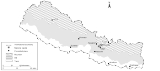
Geography of Nepal
Encyclopedia
Nepal
measures about 800 kilometres (497 mi) along its himalayan axis by 150 to 250 km (93.2 to 155.3 mi) across. With 147181 square kilometre it slightly outranks Bangladesh
or the state of Arkansas
. Nepal is landlocked by India on three sides and China's Xizang Autonomous Region (Tibet
) to the north. West Bengal
's narrow Siliguri Corridor or Chicken's Neck separate Nepal and Bangladesh
. To the east are India—and Bhutan
. Nepal depends on India for transit facilities and access to the sea—the Bay of Bengal—even for most goods imported from China.
Geographic coordinates: 28°00′N 84°00′E
or Sagarmatha. In addition to the continuum from tropical warmth to cold comparable to polar regions, average annual precipitation varies from as little as 160 millimetres (6.3 in) in the rainshadow north of the Himalaya to as much as 5500 millimetres (216.5 in) on windward slopes.
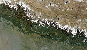
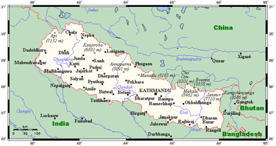
Along a south-to-north transect, Nepal can be divided into three belts: Terai, Hill and Mountain Regions. In the other direction it is divided into three major river systems, from east to west: Koshi
, Gandaki/Narayani and Karnali (including the Mahakali/Sarda along the western border), all tributaries of the Ganges
. The Ganges-Yarlung Zangbo
/Brahmaputra
watershed largely coincides with the Nepal-Tibet border, however several Ganges tributaries rise inside Tibet.
or Madhesh
region begins at the Indian border and includes the southernmost part of the flat, intensively farmed Gangetic Plain called the Outer Terai. This is culturally an extension of northern India with Hindi
, Awadhi, Bhojpuri and Maithili
spoken more than Nepali
, however it was annexed to Nepal by conquest and by treaty
with the British
.
The Outer Terai ends at the first range of foothills called the Siwaliks or Churia. This range has a densely forested skirt of coarse alluvium called the bhabhar
along its base. Below the bhabhar, finer, less permeable sediments force groundwater to the surface in a zone of springs and marshes. In Persian, terai refers to wet or marshy ground. Before the use of DDT it was dangerously infested with malaria. Nepal's rulers used it as a defensive frontier called the char kose jhadi (twelve kilometer forest)
Above the bhabhar belt, the Siwaliks rise to about 700 metres (2,297 ft) with peaks as high as 1000 metres (3,281 ft), steeper on their southern flanks because of faults known as the Main Frontal Thrust. This range is composed of poorly consolidated, coarse sediments that do not retain water or support soil development so there is virtually no agricultural potential. Hillside vegetation is limited to scrub forest and the area functions as a deserted buffer zone allowing the development of distinctive cultures in valleys and hills further north.
In several places beyond the Siwaliks there are dun valleys called Inner Terai
(Bhitri Madesh) with productive soil. Among these are Dang and Deukhuri in western Nepal and the Rapti Valley (Chitwan) in central Nepal. Population in these valleys was historically limited by malaria and mainly of the Tharu ethnic group that has genetic resistance. Around 1960 DDT
came into use to suppress mosquitos and the way was open to settlement from the land-poor hills to the detriment of Tharus.
The Terai ends and the Hills begin at a higher range of foothills called the Mahabharat Range
.
(Pahar in Nepali) is mostly between 700 and 4000 m (2,296.6 and 13,123.4 ft) altitude. This region begins at the Mahabharat Range (Lesser Himalaya) where a fault system called the Main Boundary Thrust creates an escarpment 1000 to 1500 m (3,280.8 to 4,921.3 ft) high, to a crest between 1500 and 2700 m (4,921.3 and 8,858.3 ft). These steep southern slopes are nearly uninhabited, thus an effective buffer between languages and culture in the Terai and Hill regions. Northern slopes are gentler and moderately well populated.
North of this range, Nepali
-speaking Hindus and Newar
merchants who also speak Newari
densely populate valleys suited to rice
cultivation as high as 2000 metres (6,562 ft). The increasingly urbanized Kathmandu and Pokhara valleys fall within this region. Indigenous janajati ethnic groups—natively speaking highly localized Tibeto-Burman languages and dialects—populate hillsides up to about 3000 metres (9,843 ft). This group includes Magar and Kham Magar
west of Pokhara, Gurung
south of the Annapurnas, Tamang
around the periphery of Kathmandu Valley
and Rai
and Limbu
further east. Beyond microclimates suited to rice cultivation and proximity to water for irrigation, these cultivate maize
, millet
, barley
and potato
es as staple crops. Temperate and subtropical fruits are grown as cash crops. Marijuana
is grown and processed into Charas
(hashish
), but less than was produced before international pressure persuaded the government to outlaw it in 1976. There is increasing reliance on animal husbandry with elevation, using land above 3000 metres (9,843 ft) for summer grazing and moving herds to lower elevations in winter
. Outside the rice-growing lower valleys, hill populations suffer chronic food deficits. Many menfolk find employment in the Terai, in India or overseas to earn cash for imported grain. The Hill region ends dramatically where the main Himalayan Range abruptly rises thousands of meters.
 The Mountain Region or Parbat abruptly rises into the zone of perpetual snow along the Main Central Thust fault zone. South of this fault system, "hills" do not greatly exceed treeline at about 3500 metres (11,483 ft). North of it the Himalayas rise as a virtual wall beyond the snowline at 5000 to 5500 m (16,404.2 to 18,044.6 ft) to some 90 peaks over 7000 metres (22,966 ft) and eight exceeding 8000 metres (26,247 ft) including Mount Everest
at 8848 metres (29,029 ft) and Kanchenjunga at 8598 metres (28,208.7 ft). Unlike the Mahabharats, the Himalaya are not continuous across Nepal. Instead there are about 25 subranges including the Kanchenjunga massif, Kumbu around Mt. Everest. Langtang
north of Kathmandu, Annapurna
north of Pokhara
and Dhaulagiri
further west, then Kanjiroba north of Jumla
.
The main watershed between the Brahmaputra
(called Yarlung Tsangpo
in Tibet
) and the Ganges system (including all of Nepal) actually lies north of the highest ranges. Alpine, often semi-arid valleys—including Humla
, Jumla
, Dolpo
, Mustang
, Manang
and Khumbu
-- cut between himalayan subranges or lie north of them. Some of these valleys historically were more accessible from Tibet
than Nepal and are populated by people with Tibetan
affinities called Bhotiya
or Bhutia
including the famous Sherpas
in Kumbu valley near Mount Everest. With Chinese cultural hegemony
in Tibet itself, these valleys have become repositories of traditional ways. Valleys with better access from the hill regions to the south are culturally linked to Nepal as well as Tibet, notably the Kali Gandaki Gorge
where Thakali
culture shows influences in both directions.
Permanent villages in the mountain region stand as high as 4500 metres (14,764 ft) with summer encampments even higher. These peoples traditionally grazed yak
s, grew cold-tolerant crops such as potato
es, barley
, buckwheat
and millet
, and traded across the mountains, e.g. Tibetan salt for rice
from lowlands in Nepal and India. Since trade was restricted in the 1950s they have found work as high altitude porters, guides, cooks and other accessories to tourism and alpinism.
 Nepal has tremendous variation in climate. Its latitude is about the same as that of Florida so Terai land up to 500 metres (1,640 ft) has a fully tropical climate, with a subtropical zone extending up to 1200 metres (3,937 ft) which is the lower limit of frost in winter. Warm temperate climates prevail from 1200 to 2400 m (3,937 to 7,874 ft) where snow occasionally falls. Then there is a cold zone to 3600 metres (11,811 ft) (treeline), a subarctic or alpine zone to 4400 metres (14,436 ft) and fully arctic climate above that. Precipitation generally decreases from east to west with increasing distance from the Bay of Bengal
, source of the summer monsoon. Eastern Nepal gets about 2500 mm (98.4 in) annually; the Kathmandu area about 1400 mm (55.1 in) and western Nepal about 1000 mm (39.4 in). This pattern is modified by adabiatic effects as rising air masses cool and drop their moisture content on windward slopes, then warm up as they descend so relative humidity drops. Annual precipitation reaches 5500 mm (216.5 in) on windward slopes in the Annapurna
Himalaya beyond a relatively low stretch of the Mahabharat Range. In rainshadows beyond the high mountains, annual precipitation drops as low as 160 mm (6.3 in), creating a cold semi-desert.
Furthermore the year is divided into a wet season from June to September—as summer warmth over Inner Asia creates a low pressure zone that draws in air from the Indian Ocean—and a dry season from October to June as cold temperatures in the vast interior creates a high pressure zone causing dry air to flow outward. April and May are months of intense water stress when cumulative effects of the long dry season are exacerbated by temperatures rising over 40 °C (104 °F). Seasonal drought intensifies in the Siwaliks hills consisting of poorly-consolidated, coarse, highly permeable sediments that do not retain water, so hillsides are covered with tropical scrub forest that is extremely drought-tolerant. In fact outside marsh and riparian zones, most of Nepal's native vegetation is adapted to withstand drought, although less so at higher elevations where cooler temperatures mean less water stress.
The monsoon is preceded by a buildup of thunderstorm activity in the hills that helps farmers irrigate rice seedbeds. Sustained rain on average arrives in early June as rising temperatures over Inner Asia creates a low pressure zone that draws in air from the Indian Ocean, but this can vary up to a month. Significant failure of monsoon rains historically meant drought and famine while above-normal rains still cause flooding and landslides with losses in human lives, farmland and buildings. The monsoon also complicates transportation with roads and trails washing out while unpaved roads and airstrips may become unusable and cloud cover reduces safety margins for aviation. Rains diminish in September and generally end by mid-October, ushering in generally cool, clear, and dry weather, as well as the most relaxed and jovial period in Nepal. By this time, the harvest is completed and people are in a festive mood. The two biggest and most important Hindu festivals-- Dashain and Tihar (Dipawali
)--arrive during this period, about one month apart. The postmonsoon season lasts until about December.
After the postmonsoon comes the winter monsoon, a strong northeasterly flow marked by occasional, short rainfalls in the lowlands and plains and snowfalls in the high-altitude areas. Precipitation varies from year to year but increases markedly with elevation. Adequate snowfall in the Himalaya is important for sufficient spring and summer meltwater for irrigation in the lower hills and valleys. At lower elevations, winter rainfall is needed for the success of winter crops such as wheat, barley and vegetables. In this season the Himalaya function as a barrier to cold air masses from Inner Asia, so southern Nepal and northern India have warmer winters than would otherwise be the case. April and May are dry and hot, especially below 1200 metres (3,937 ft) where afternoon temperatures may exceed 40 °C (104 °F).
s, from tropical savannas
along the Indian border, to subtropical broadleaf
and coniferous forests
in the hills, to temperate
broadleaf
and coniferous forests on the slopes of the Himalaya, to montane grasslands and shrublands
, and finally rock and ice at the highest elevations.
This corresponds to the Terai-Duar savanna and grasslands
ecoregion.
Subtropical forests dominate the lower elevations of the Hill Region. They form a mosaic running east-west across Nepal, with Himalayan subtropical broadleaf forests
between 500 and 1000 m (1,640.4 and 3,280.8 ft) and Himalayan subtropical pine forests
between 1000 and 2000 m (3,280.8 and 6,561.7 ft). At higher elevations, to 3000 metres (9,843 ft), are found temperate broadleaf forests: eastern Himalayan broadleaf forests
to the east of the Gandaki River and western Himalayan broadleaf forests
to the west.
The native forests of the Mountain Region change from east to west as precipitation decreases. They can be broadly classified by their relation to the Gandaki River. From 3000 to 4000 m (9,842.5 to 13,123.4 ft) are the eastern
and western Himalayan subalpine conifer forests
. To 5500 metres (18,045 ft) are the eastern
and western Himalayan alpine shrub and meadows
.
, Gandaki/Narayani, Karnali/Goghra and Mahakali
-- originate in multiple tributaries rising in or beyond the high Himalaya that maintain substantial flows from snowmelt through the hot, droughty spring before the summer monsoon. These tributaries cross the highest mountains in deep gorges, flow south through the Middle Hills, then join in candelabra
-like configuration before crossing the Mahabharat Range
and emerging onto the plains where they have deposited megafans
exceeding 10000 square kilometre area.
The Koshi is also called Sapta Koshi for its seven Himalayan tributaries in eastern Nepal: Indrawati
, Sun Koshi
, Tama Koshi, Dudh Koshi
, Liku, Arun
, and Tamur
. The Arun rises in Tibet some 150 km. beyond Nepal's northern border. A tributary of the Sun Koshi, Bhote Koshi
also rises in Tibet and is followed by the Arniko Highway
connecting Kathmandu and Lhasa
.
The Gandaki/Narayani has seven Himalayan tributaries in the center of the country: Daraudi, Seti Gandaki, Madi, Kali, Marsyandi, Budhi, and Trisuli also called Sapta Gandaki. The Kali Gandaki rises on the edge of the Tibetan Plateau
and flows through the semi-independent Kingdom of Mustang
, then between the 8000 metres (26,247 ft) Dhaulagiri
and Annapurna
ranges in the world's deepest valley
. The Trisuli
rises north of the international border inside Tibet. After the seven upper tributaries join, the river becomes the Narayani inside Nepal and is joined by the (East) Rapti from Chitwan Valley
. Crossing into India
, its name changes to Gandak.
The Karnali
drains western Nepal, with the Bheri
and Seti
as major tributaries. The upper Bheri drains Dolpo
, a remote valley beyond the Dhaulagiri
Himalaya with traditional Tibetan cultural affinities. The upper Karnali rises inside Tibet near sacred Lake Manasarovar
and Mount Kailash
. The area around these features is the hydrographic nexus of South Asia
since it holds the sources of the Indus
and its major tributary the Sutlej
, the Karnali -- a Ganges tributary -- and the Yarlung Zangbo
/Brahmaputra
. It is the center of the universe according to traditional cosmography
. The Mahakali
or Kali along the Nepal-India border on the west joins the Karnali in India, where the river is known as Goghra or Ghaghara.
Second category rivers rise in the Middle Hills and Mahabharat Range, from east to west the Mechi
, Kankai
and Kamala
south of the Kosi; the Bagmati
that drains Kathmandu Valley
between the Kosi and Gandaki systems, then the West Rapti
and the Babai between the Gandaki and Karnali systems. Without glacial sources, annual flow regimes in these rivers are more variable although limited flow persists through the dry season.
Third category rivers rise in the outermost Siwalik foothills and are mostly seasonal.
None of these river systems support significant commercial navigation. Instead, deep gorges create obstacles to establishing transport and communication networks and de-fragmenting the economy. Foot-trails are still primary transportation routes in many hill districts.
's Sorrow for its history of urban flooding. Koshi River in the first category caused a major flood in August 2008
in Bihar
state, India after breaking through a poorly-maintained embankment just inside Nepal.
Since uplift and erosion are more or less in equilibrium in the Himalaya, rapid uplift is balanced by annual increments of cubic kilometers of sediments washing down from the mountains, then on the plains settling out of suspension on vast alluvial fans or inland deltas over which rivers meander and change course at least every few decades, causing some experts to question whether manmade embankments can contain the problem of flooding. Traditional Mithila
culture along the lower Koshi in Nepal and Bihar celebrated the river as the giver of life for its fertile alluvial soil, yet also the taker of life through its catastrophic floods.
Another approach would be to build large dams—in gorges crossing the Mahabharat Range or further upstream—with storage capacities measured in cubic kilometers to capture high flows during the monsoon when there is usually enough rainfall on the plains if not flooding, then releasing water for hydroelectric generation and irrigation especially during the hot and dry pre-monsoon "summer". Nepal would appear to have unusual potential given its average annual 150 cm. of precipitation and thousands of meters of relief between mountains and plains, but there has only been limited development of this potential for example on the Kali Gandaki north of Tansen
.
Building dams in Nepal is controversial for several reasons. First, the region is seismically active. Dam failures caused by earthquakes could cause tremendous death and destruction downstream, particularly on the densely populated Gangetic Plain. Second, global warming has led to the formation of glacial lakes dammed by unstable moraines. Sudden failures of these moraines could lead to cascading failures of manmade structures downstream. Third, sedimentation rates in the Himalaya are extremely high, leading to rapid loss of storage capacity as sediments accumulate behind dams. Fourth, there are complicated questions of cross-border equity in how India and Nepal would share costs and benefits that have proven difficult to resolve in the context of frequent acrimony between the two countries.
Area - comparative:
Land boundaries:
Coastline:
Maritime claims:
Elevation extremes:
Land use:
Irrigated land:
figures from 2005. FAO estimates that around 9.6% of Nepal's forest cover consists of primary forest which is relatively intact. About 12.1% Nepal's forest is classified as protected while about 21.4% is conserved according to FAO. About 5.1% Nepal's forests are classified as production forest. Between 2000-2005, Nepal lost about 2640 square kilometre of forest. Nepal's 2000-2005 total deforestation rate was about 1.4% per year meaning it lost an average of 530 square kilometre of forest annually. Nepal's total deforestation rate from 1990-2000 was 920 square kilometre or 2.1% per year. The 2000-2005 true deforestation rate in Nepal, defined as the loss of primary forest, is -0.4% or 70 square kilometre per year.
Deforestation is driven by multiple processes. In the hills, conversion of forests to agricultural land—even on steep hillsides via terracing—is historically important, but has lessened in recent decades due to a shortage of remaining suitable terrain in the hills while mosquito suppression having opened formerly malarial land for settlement in the Terai. As a result, forest land in the Terai is being cleared by settlers.
In the hills, greater contemporary impacts involve degradation of forests rather than outright clearing. Degradation is caused by harvesting firewood, and to a lesser extent wood for traditional architecture. These harvests are often carried to unsustainable levels. Trees are also severely damaged by intensive harvesting of leaves as fodder, especially in the driest months preceding the summer monsoon. Households typically keep at least one cow or buffalo for milk production and may also keep oxen for agricultural labor. In addition goats are herded as the main source of meat that is culturally acceptable to upper-caste Hindus.
Environment - current issues:
Environment - international agreements:
Geography - note:
Nepal
Nepal , officially the Federal Democratic Republic of Nepal, is a landlocked sovereign state located in South Asia. It is located in the Himalayas and bordered to the north by the People's Republic of China, and to the south, east, and west by the Republic of India...
measures about 800 kilometres (497 mi) along its himalayan axis by 150 to 250 km (93.2 to 155.3 mi) across. With 147181 square kilometre it slightly outranks Bangladesh
Bangladesh
Bangladesh , officially the People's Republic of Bangladesh is a sovereign state located in South Asia. It is bordered by India on all sides except for a small border with Burma to the far southeast and by the Bay of Bengal to the south...
or the state of Arkansas
Arkansas
Arkansas is a state located in the southern region of the United States. Its name is an Algonquian name of the Quapaw Indians. Arkansas shares borders with six states , and its eastern border is largely defined by the Mississippi River...
. Nepal is landlocked by India on three sides and China's Xizang Autonomous Region (Tibet
Tibet
Tibet is a plateau region in Asia, north-east of the Himalayas. It is the traditional homeland of the Tibetan people as well as some other ethnic groups such as Monpas, Qiang, and Lhobas, and is now also inhabited by considerable numbers of Han and Hui people...
) to the north. West Bengal
West Bengal
West Bengal is a state in the eastern region of India and is the nation's fourth-most populous. It is also the seventh-most populous sub-national entity in the world, with over 91 million inhabitants. A major agricultural producer, West Bengal is the sixth-largest contributor to India's GDP...
's narrow Siliguri Corridor or Chicken's Neck separate Nepal and Bangladesh
Bangladesh
Bangladesh , officially the People's Republic of Bangladesh is a sovereign state located in South Asia. It is bordered by India on all sides except for a small border with Burma to the far southeast and by the Bay of Bengal to the south...
. To the east are India—and Bhutan
Bhutan
Bhutan , officially the Kingdom of Bhutan, is a landlocked state in South Asia, located at the eastern end of the Himalayas and bordered to the south, east and west by the Republic of India and to the north by the People's Republic of China...
. Nepal depends on India for transit facilities and access to the sea—the Bay of Bengal—even for most goods imported from China.
Geographic coordinates: 28°00′N 84°00′E
The Land
For a small country, Nepal has tremendous geographic diversity. It rises from less than 100 metres (328 ft) elevation in the tropical Terai—the northern rim of the Gangetic Plain, beyond the perpetual snow line to some 90 peaks over 7000 metres (22,966 ft) including Earth's highest 8848 metres (29,029 ft) Mount EverestMount Everest
Mount Everest is the world's highest mountain, with a peak at above sea level. It is located in the Mahalangur section of the Himalayas. The international boundary runs across the precise summit point...
or Sagarmatha. In addition to the continuum from tropical warmth to cold comparable to polar regions, average annual precipitation varies from as little as 160 millimetres (6.3 in) in the rainshadow north of the Himalaya to as much as 5500 millimetres (216.5 in) on windward slopes.
Along a south-to-north transect, Nepal can be divided into three belts: Terai, Hill and Mountain Regions. In the other direction it is divided into three major river systems, from east to west: Koshi
Koshi River
The Kosi River or Koshi —also Saptakoshi for its seven Himalayan tributaries—is a trans-boundary river flowing through Nepal and India. Some of the rivers of the Koshi system, such as the Arun, the Sun Kosi and the Bhote Koshi, originate in the Tibet Autonomous Region of China...
, Gandaki/Narayani and Karnali (including the Mahakali/Sarda along the western border), all tributaries of the Ganges
Ganges River
The Ganges or Ganga, , is a trans-boundary river of India and Bangladesh. The river rises in the western Himalayas in the Indian state of Uttarakhand, and flows south and east through the Gangetic Plain of North India into Bangladesh, where it empties into the Bay of Bengal. By discharge it...
. The Ganges-Yarlung Zangbo
Yarlung Zangbo River
Yarlung River is a watercourse that originates upstream from the South Tibet Valley and Yarlung Zangbo Grand Canyon, in Tibet. It then passes through the state of Arunachal Pradesh, India, where it is known as the Dihang....
/Brahmaputra
Brahmaputra River
The Brahmaputra , also called Tsangpo-Brahmaputra, is a trans-boundary river and one of the major rivers of Asia. It is the only Indian river that is attributed the masculine gender and thus referred to as a in Indo-Aryan languages and languages with Indo-Aryan influence...
watershed largely coincides with the Nepal-Tibet border, however several Ganges tributaries rise inside Tibet.
The Terai Region
The TeraiTerai
The Terai is a belt of marshy grasslands, savannas, and forests located south of the outer foothills of the Himalaya, the Siwalik Hills, and north of the Indo-Gangetic Plain of the Ganges, Brahmaputra and their tributaries. The Terai belongs to the Terai-Duar savanna and grasslands ecoregion...
or Madhesh
Madhesh
Madhesh is a term given to areas of the Nepali outer Terai or to the outer Terai as a whole inhabited by peoples who are racially, culturally and linguistically related to people on the Indian side of the border. These peoples are referred to or refer to themselves as Madheshi...
region begins at the Indian border and includes the southernmost part of the flat, intensively farmed Gangetic Plain called the Outer Terai. This is culturally an extension of northern India with Hindi
Hindi
Standard Hindi, or more precisely Modern Standard Hindi, also known as Manak Hindi , High Hindi, Nagari Hindi, and Literary Hindi, is a standardized and sanskritized register of the Hindustani language derived from the Khariboli dialect of Delhi...
, Awadhi, Bhojpuri and Maithili
Maithili language
Maithili language is spoken in the eastern region of India and South-eastern region of Nepal. The native speakers of Maithili reside in Bihar, Jharkhand,parts of West Bengal and South-east Nepal...
spoken more than Nepali
Nepali language
Nepali or Nepalese is a language in the Indo-Aryan branch of the Indo-European language family.It is the official language and de facto lingua franca of Nepal and is also spoken in Bhutan, parts of India and parts of Myanmar...
, however it was annexed to Nepal by conquest and by treaty
Sugauli Treaty
The Sugauli Treaty was signed on December 2, 1815 and ratified by March 4, 1816, between the British East India Company and Nepal, which was a kingdom during that era. This ended the second British invasion of the Himalayan kingdom during the Anglo-Nepalese War...
with the British
British Raj
British Raj was the British rule in the Indian subcontinent between 1858 and 1947; The term can also refer to the period of dominion...
.
The Outer Terai ends at the first range of foothills called the Siwaliks or Churia. This range has a densely forested skirt of coarse alluvium called the bhabhar
Bhabhar
Bhabhar is the region south of the Lower Himalayas and the Siwalik Hills It is the alluvial apron of sediments washed down from the Siwaliks along the northern edge of the Indo-Gangetic Plain.-Etymology:...
along its base. Below the bhabhar, finer, less permeable sediments force groundwater to the surface in a zone of springs and marshes. In Persian, terai refers to wet or marshy ground. Before the use of DDT it was dangerously infested with malaria. Nepal's rulers used it as a defensive frontier called the char kose jhadi (twelve kilometer forest)
Above the bhabhar belt, the Siwaliks rise to about 700 metres (2,297 ft) with peaks as high as 1000 metres (3,281 ft), steeper on their southern flanks because of faults known as the Main Frontal Thrust. This range is composed of poorly consolidated, coarse sediments that do not retain water or support soil development so there is virtually no agricultural potential. Hillside vegetation is limited to scrub forest and the area functions as a deserted buffer zone allowing the development of distinctive cultures in valleys and hills further north.
In several places beyond the Siwaliks there are dun valleys called Inner Terai
Inner Terai Valleys of Nepal
The Inner Terai Valleys or Bhitri tarai are various elongated valleys in Nepal situated between the Himalayan foothills, the 600–900 m high Siwalik or Churia Range and the 2,000-3,000 m high Mahabharat Range further north. Major examples are the Chitwan Valley southwest of Kathmandu and the...
(Bhitri Madesh) with productive soil. Among these are Dang and Deukhuri in western Nepal and the Rapti Valley (Chitwan) in central Nepal. Population in these valleys was historically limited by malaria and mainly of the Tharu ethnic group that has genetic resistance. Around 1960 DDT
DDT
DDT is one of the most well-known synthetic insecticides. It is a chemical with a long, unique, and controversial history....
came into use to suppress mosquitos and the way was open to settlement from the land-poor hills to the detriment of Tharus.
The Terai ends and the Hills begin at a higher range of foothills called the Mahabharat Range
Mahabharat Lekh
The Mahabharat Range -- also called the Lesser Himalaya -- is a major east-west mountain range [a series of east-west mountain ranges] with elevations 1,500 to 2,700 metres along the crest, paralleling the much higher Great Himalaya range from the Indus River in Pakistan across northern India,...
.
The Hill Region
Situated south of the Mountain Region, the Hill RegionHill Region
Nepal's Hill region consists predominantly of the land area from 600 metres to 1,800 metres above sea level.The area consists of the historically important then state: Gorkha district, Syangja, Kaski, Lamjung, and Tanahun, among others....
(Pahar in Nepali) is mostly between 700 and 4000 m (2,296.6 and 13,123.4 ft) altitude. This region begins at the Mahabharat Range (Lesser Himalaya) where a fault system called the Main Boundary Thrust creates an escarpment 1000 to 1500 m (3,280.8 to 4,921.3 ft) high, to a crest between 1500 and 2700 m (4,921.3 and 8,858.3 ft). These steep southern slopes are nearly uninhabited, thus an effective buffer between languages and culture in the Terai and Hill regions. Northern slopes are gentler and moderately well populated.
North of this range, Nepali
Nepali language
Nepali or Nepalese is a language in the Indo-Aryan branch of the Indo-European language family.It is the official language and de facto lingua franca of Nepal and is also spoken in Bhutan, parts of India and parts of Myanmar...
-speaking Hindus and Newar
Newar
The Newa , Newār or Newāl) are the indigenous people and the creators of the historical civilization of Nepal's Kathmandu Valley. The valley and surrounding territory have been known from ancient times as Nepal Mandala, its limits ever changing through history.Newas have lived in the Kathmandu...
merchants who also speak Newari
Nepal Bhasa
Nepal Bhasa is one of the major languages of Nepal, and is also spoken in India, particularly in Sikkim where it is one of the 11 official languages. Nepal Bhasa is the mother tongue of about 3% of the people in Nepal . It is spoken mainly by the Newars, who chiefly inhabit the towns of the...
densely populate valleys suited to rice
Rice
Rice is the seed of the monocot plants Oryza sativa or Oryza glaberrima . As a cereal grain, it is the most important staple food for a large part of the world's human population, especially in East Asia, Southeast Asia, South Asia, the Middle East, and the West Indies...
cultivation as high as 2000 metres (6,562 ft). The increasingly urbanized Kathmandu and Pokhara valleys fall within this region. Indigenous janajati ethnic groups—natively speaking highly localized Tibeto-Burman languages and dialects—populate hillsides up to about 3000 metres (9,843 ft). This group includes Magar and Kham Magar
Kham Magar
Kham Magar and Northern Magar are descriptive terms invented by academic linguists and anthropologists for a nationality in the Middle Hills of mid-western Nepal inhabiting highlands extending through eastern Rukum and northern Salyan, Rolpa and Pyuthan Districts in Rapti Zone as well as adjacent...
west of Pokhara, Gurung
Gurung
The Gurung people, also called Tamu, are an ethnic group that migrated from Mongolia in the 6th century to the central region of Nepal. Gurungs, like other east Asian featured peoples of Nepal such as Sherpa, Tamang, Thakali, Magar, Manaaggi, Mustaaggi, and Walunggi, are the indigenous people of...
south of the Annapurnas, Tamang
Tamang
The Tamangs are the ancient and original inhabitants of the mountains and plains of the Himalayan regions of Nepal and India. Their ancient capital being Yambu - modern day Kathmandu. They have their own distinct culture, language and religion. Their ancestral domain is popularly known as...
around the periphery of Kathmandu Valley
Kathmandu Valley
The Kathmandu Valley , located in Nepal, lies at the crossroads of ancient civilizations of Asia, and has at least 130 important monuments, including several places of pilgrimage for the Hindus and the Buddhists. There are seven UNESCO World Heritage Sites within this valley.-Etymology:The city of...
and Rai
Rai people
The Rai are one of Nepal's most ancient indigenous ethnolinguistic groups. They were Raya meaning king. Once someone was recognized as a ruler then Hindus awarded the title Raja, Rai, Raya, Malla etc. When the king Pritivi Narayan Shah couldn't defeat Kirant king , he somehow took them in...
and Limbu
Limbu people
The Yakthung or Limbu tribes and clans belong to the Kirati nation or to the Kirat confederation.They are indigenous to the hill and mountainous regions of east Nepal between the Arun and Mechi rivers to as far as Southern Tibet, Bhutan and Sikkim....
further east. Beyond microclimates suited to rice cultivation and proximity to water for irrigation, these cultivate maize
Maize
Maize known in many English-speaking countries as corn or mielie/mealie, is a grain domesticated by indigenous peoples in Mesoamerica in prehistoric times. The leafy stalk produces ears which contain seeds called kernels. Though technically a grain, maize kernels are used in cooking as a vegetable...
, millet
Millet
The millets are a group of small-seeded species of cereal crops or grains, widely grown around the world for food and fodder. They do not form a taxonomic group, but rather a functional or agronomic one. Their essential similarities are that they are small-seeded grasses grown in difficult...
, barley
Barley
Barley is a major cereal grain, a member of the grass family. It serves as a major animal fodder, as a base malt for beer and certain distilled beverages, and as a component of various health foods...
and potato
Potato
The potato is a starchy, tuberous crop from the perennial Solanum tuberosum of the Solanaceae family . The word potato may refer to the plant itself as well as the edible tuber. In the region of the Andes, there are some other closely related cultivated potato species...
es as staple crops. Temperate and subtropical fruits are grown as cash crops. Marijuana
Cannabis (drug)
Cannabis, also known as marijuana among many other names, refers to any number of preparations of the Cannabis plant intended for use as a psychoactive drug or for medicinal purposes. The English term marijuana comes from the Mexican Spanish word marihuana...
is grown and processed into Charas
Charas
Charas is the name given to a hashish form of cannabis which is hand-made in Afghanistan, Pakistan, Nepal and India. It is made from the resin of the cannabis plant...
(hashish
Hashish
Hashish is a cannabis preparation composed of compressed stalked resin glands, called trichomes, collected from the unfertilized buds of the cannabis plant. It contains the same active ingredients but in higher concentrations than unsifted buds or leaves...
), but less than was produced before international pressure persuaded the government to outlaw it in 1976. There is increasing reliance on animal husbandry with elevation, using land above 3000 metres (9,843 ft) for summer grazing and moving herds to lower elevations in winter
Transhumance
Transhumance is the seasonal movement of people with their livestock between fixed summer and winter pastures. In montane regions it implies movement between higher pastures in summer and to lower valleys in winter. Herders have a permanent home, typically in valleys. Only the herds travel, with...
. Outside the rice-growing lower valleys, hill populations suffer chronic food deficits. Many menfolk find employment in the Terai, in India or overseas to earn cash for imported grain. The Hill region ends dramatically where the main Himalayan Range abruptly rises thousands of meters.
The Mountain Region
Mount Everest
Mount Everest is the world's highest mountain, with a peak at above sea level. It is located in the Mahalangur section of the Himalayas. The international boundary runs across the precise summit point...
at 8848 metres (29,029 ft) and Kanchenjunga at 8598 metres (28,208.7 ft). Unlike the Mahabharats, the Himalaya are not continuous across Nepal. Instead there are about 25 subranges including the Kanchenjunga massif, Kumbu around Mt. Everest. Langtang
Langtang
Langtang is a region in Nepal to the north of Kathmandu and bordering Tibet. It is protected as Langtang National Park and has a number of high peaks including Langtang Lirung . As of 2010, the entrance ticket to the park cost 2400 Nepali Rupees for foreigners.About 4,500 people live inside the...
north of Kathmandu, Annapurna
Annapurna
Annapurna is a section of the Himalayas in north-central Nepal that includes Annapurna I, thirteen additional peaks over and 16 more over ....
north of Pokhara
Pokhara
Pokhara Sub-Metropolitan City is the second largest city of Nepal. Pokhara is city of close to 350,000 inhabitants in central Nepal located at 28.25°N, 83.99°E, which is the centre of the country from east to west or from north to south, 198 km west of Kathmandu or 90 km west of Mugling, and...
and Dhaulagiri
Dhaulagiri
Dhaulagiri is Earth's seventh highest mountain at ; one of fourteen over eight thousand metres. Dhaulagiri was first climbed May 13, 1960 by a Swiss/Austrian expedition....
further west, then Kanjiroba north of Jumla
Jumla District
Jumla District|Jumla]] as its district headquarters, covers an area of 2,531 km² and has a population of 89,427.The origin of Nepali language is Sinja of Jumla...
.
The main watershed between the Brahmaputra
Brahmaputra River
The Brahmaputra , also called Tsangpo-Brahmaputra, is a trans-boundary river and one of the major rivers of Asia. It is the only Indian river that is attributed the masculine gender and thus referred to as a in Indo-Aryan languages and languages with Indo-Aryan influence...
(called Yarlung Tsangpo
Yarlung Zangbo River
Yarlung River is a watercourse that originates upstream from the South Tibet Valley and Yarlung Zangbo Grand Canyon, in Tibet. It then passes through the state of Arunachal Pradesh, India, where it is known as the Dihang....
in Tibet
Tibet
Tibet is a plateau region in Asia, north-east of the Himalayas. It is the traditional homeland of the Tibetan people as well as some other ethnic groups such as Monpas, Qiang, and Lhobas, and is now also inhabited by considerable numbers of Han and Hui people...
) and the Ganges system (including all of Nepal) actually lies north of the highest ranges. Alpine, often semi-arid valleys—including Humla
Humla District
Humla District of 40,595.The Northern part of Humla District is inhabited by Buddhists,originating from Tibet, whereas the South is mostly inhabited by Hindus.-Towns and villages:Bargaun,Chhipra,Dami,Dandafaya,Gothi,Hepka,Jaira,Kalika,Kermi,...
, Jumla
Jumla District
Jumla District|Jumla]] as its district headquarters, covers an area of 2,531 km² and has a population of 89,427.The origin of Nepali language is Sinja of Jumla...
, Dolpo
Dolpo
Dolpo is a high-altitude culturally Tibetan region in the upper part of the Dolpa District of western Nepal, bordered in the north by the Tibet Autonomous Region of China. Part of the region lies in Shey Phoksundo National Park...
, Mustang
Mustang District
Mustang District, a part of Dhawalagiri Zone, is one of the seventy-five districts of Nepal, a landlocked country of South Asia. The district, with Jomsom as its headquarters, covers an area of 3,573 km² and has a population of 14,981....
, Manang
Manang
Manang is a town in the Manang District of Nepal. It is located at 28°40'0N 84°1'0E with an altitude of . At the time of the 1991 Nepal census it had a population of 391 people living in 120 individual households....
and Khumbu
Khumbu
Khumbu is located in northeastern Nepal on the Nepalese side of Mount Everest. It is part of the Solukhumbu District, which in turn is part of the Sagarmatha Zone. Khumbu is one of three subregions of the main Khambu and Sherpa settlement of the Himalaya, the other two being Solu and Pharak...
-- cut between himalayan subranges or lie north of them. Some of these valleys historically were more accessible from Tibet
Tibet
Tibet is a plateau region in Asia, north-east of the Himalayas. It is the traditional homeland of the Tibetan people as well as some other ethnic groups such as Monpas, Qiang, and Lhobas, and is now also inhabited by considerable numbers of Han and Hui people...
than Nepal and are populated by people with Tibetan
Tibetan people
The Tibetan people are an ethnic group that is native to Tibet, which is mostly in the People's Republic of China. They number 5.4 million and are the 10th largest ethnic group in the country. Significant Tibetan minorities also live in India, Nepal, and Bhutan...
affinities called Bhotiya
Bhotiya
The Bhotiya are groups of ethno-linguistically Tibetan people living in the trans-Himalayan region that divides India from the People's Republic of China, and were originally a hill tribe. Their name, Bhotiya, derives from the word Bod , which is the Classical Tibetan name for Tibet...
or Bhutia
Bhutia
The Bhutia are ethnic Tibetans who speak Sikkimese, a Tibetan dialect fairly mutually intelligible to standard Tibetan. In 2001, the Bhutia numbered around 70,300...
including the famous Sherpas
Sherpa people
The Sherpa are an ethnic group from the most mountainous region of Nepal, high in the Himalayas. Sherpas migrated from the Kham region in eastern Tibet to Nepal within the last 300–400 years.The initial mountainous migration from Tibet was a search for beyul...
in Kumbu valley near Mount Everest. With Chinese cultural hegemony
Sinicization of Tibet
The sinicization of Tibet is the alleged change of Tibetan society to Han Chinese standards, by means of cultural assimilation, migration, and political reform. Sinicization on the one hand is an inevitable consequence of the presence of a large number of Han Chinese in Tibet and on the other hand...
in Tibet itself, these valleys have become repositories of traditional ways. Valleys with better access from the hill regions to the south are culturally linked to Nepal as well as Tibet, notably the Kali Gandaki Gorge
Kali Gandaki Gorge
The Kali Gandaki Gorge or Andha Galchi is the gorge of the Kali Gandaki in the Himalayas in Nepal, by some measures the deepest gorge in the world....
where Thakali
Thakali
The Thakali are ethnolinguistic group originated from the Thak Khola region of the Mustang District in the Dhaulagiri zone of Nepal. Thakali, like Mutanggi their ancestors, culture and traditions are traced back to ancient himalayan region...
culture shows influences in both directions.
Permanent villages in the mountain region stand as high as 4500 metres (14,764 ft) with summer encampments even higher. These peoples traditionally grazed yak
Yak
The yak, Bos grunniens or Bos mutus, is a long-haired bovine found throughout the Himalayan region of south Central Asia, the Tibetan Plateau and as far north as Mongolia and Russia. In addition to a large domestic population, there is a small, vulnerable wild yak population...
s, grew cold-tolerant crops such as potato
Potato
The potato is a starchy, tuberous crop from the perennial Solanum tuberosum of the Solanaceae family . The word potato may refer to the plant itself as well as the edible tuber. In the region of the Andes, there are some other closely related cultivated potato species...
es, barley
Barley
Barley is a major cereal grain, a member of the grass family. It serves as a major animal fodder, as a base malt for beer and certain distilled beverages, and as a component of various health foods...
, buckwheat
Buckwheat
Buckwheat refers to a variety of plants in the dicot family Polygonaceae: the Eurasian genus Fagopyrum, the North American genus Eriogonum, and the Northern Hemisphere genus Fallopia. Either of the latter two may be referred to as "wild buckwheat"...
and millet
Millet
The millets are a group of small-seeded species of cereal crops or grains, widely grown around the world for food and fodder. They do not form a taxonomic group, but rather a functional or agronomic one. Their essential similarities are that they are small-seeded grasses grown in difficult...
, and traded across the mountains, e.g. Tibetan salt for rice
Rice
Rice is the seed of the monocot plants Oryza sativa or Oryza glaberrima . As a cereal grain, it is the most important staple food for a large part of the world's human population, especially in East Asia, Southeast Asia, South Asia, the Middle East, and the West Indies...
from lowlands in Nepal and India. Since trade was restricted in the 1950s they have found work as high altitude porters, guides, cooks and other accessories to tourism and alpinism.
Climate
Bay of Bengal
The Bay of Bengal , the largest bay in the world, forms the northeastern part of the Indian Ocean. It resembles a triangle in shape, and is bordered mostly by the Eastern Coast of India, southern coast of Bangladesh and Sri Lanka to the west and Burma and the Andaman and Nicobar Islands to the...
, source of the summer monsoon. Eastern Nepal gets about 2500 mm (98.4 in) annually; the Kathmandu area about 1400 mm (55.1 in) and western Nepal about 1000 mm (39.4 in). This pattern is modified by adabiatic effects as rising air masses cool and drop their moisture content on windward slopes, then warm up as they descend so relative humidity drops. Annual precipitation reaches 5500 mm (216.5 in) on windward slopes in the Annapurna
Annapurna
Annapurna is a section of the Himalayas in north-central Nepal that includes Annapurna I, thirteen additional peaks over and 16 more over ....
Himalaya beyond a relatively low stretch of the Mahabharat Range. In rainshadows beyond the high mountains, annual precipitation drops as low as 160 mm (6.3 in), creating a cold semi-desert.
Furthermore the year is divided into a wet season from June to September—as summer warmth over Inner Asia creates a low pressure zone that draws in air from the Indian Ocean—and a dry season from October to June as cold temperatures in the vast interior creates a high pressure zone causing dry air to flow outward. April and May are months of intense water stress when cumulative effects of the long dry season are exacerbated by temperatures rising over 40 °C (104 °F). Seasonal drought intensifies in the Siwaliks hills consisting of poorly-consolidated, coarse, highly permeable sediments that do not retain water, so hillsides are covered with tropical scrub forest that is extremely drought-tolerant. In fact outside marsh and riparian zones, most of Nepal's native vegetation is adapted to withstand drought, although less so at higher elevations where cooler temperatures mean less water stress.
The monsoon is preceded by a buildup of thunderstorm activity in the hills that helps farmers irrigate rice seedbeds. Sustained rain on average arrives in early June as rising temperatures over Inner Asia creates a low pressure zone that draws in air from the Indian Ocean, but this can vary up to a month. Significant failure of monsoon rains historically meant drought and famine while above-normal rains still cause flooding and landslides with losses in human lives, farmland and buildings. The monsoon also complicates transportation with roads and trails washing out while unpaved roads and airstrips may become unusable and cloud cover reduces safety margins for aviation. Rains diminish in September and generally end by mid-October, ushering in generally cool, clear, and dry weather, as well as the most relaxed and jovial period in Nepal. By this time, the harvest is completed and people are in a festive mood. The two biggest and most important Hindu festivals-- Dashain and Tihar (Dipawali
Diwali
Diwali or DeepavaliThe name of the festival in various regional languages include:, , , , , , , , , , , , , popularly known as the "festival of lights," is a festival celebrated between mid-October and mid-December for different reasons...
)--arrive during this period, about one month apart. The postmonsoon season lasts until about December.
After the postmonsoon comes the winter monsoon, a strong northeasterly flow marked by occasional, short rainfalls in the lowlands and plains and snowfalls in the high-altitude areas. Precipitation varies from year to year but increases markedly with elevation. Adequate snowfall in the Himalaya is important for sufficient spring and summer meltwater for irrigation in the lower hills and valleys. At lower elevations, winter rainfall is needed for the success of winter crops such as wheat, barley and vegetables. In this season the Himalaya function as a barrier to cold air masses from Inner Asia, so southern Nepal and northern India have warmer winters than would otherwise be the case. April and May are dry and hot, especially below 1200 metres (3,937 ft) where afternoon temperatures may exceed 40 °C (104 °F).
Environment
The dramatic changes in elevation along this transect result in a variety of biomeBiome
Biomes are climatically and geographically defined as similar climatic conditions on the Earth, such as communities of plants, animals, and soil organisms, and are often referred to as ecosystems. Some parts of the earth have more or less the same kind of abiotic and biotic factors spread over a...
s, from tropical savannas
Tropical and subtropical grasslands, savannas, and shrublands
Tropical and subtropical grasslands, savannas, and shrublands are a grassland terrestrial biome located in semi-arid to semi-humid climate regions of subtropical and tropical latitudes. Grasslands are dominated by grass and other herbaceous plants. Savannas are grasslands with scattered trees...
along the Indian border, to subtropical broadleaf
Tropical and subtropical moist broadleaf forests
Tropical and subtropical moist broadleaf forests , also known as tropical moist forests, are a tropical and subtropical forest biome....
and coniferous forests
Tropical and subtropical coniferous forests
Tropical and subtropical coniferous forests are a forest biome. They are located in regions of semi-humid climate at tropical and subtropical latitudes. Most tropical and subtropical coniferous forest ecoregions are found in the Nearctic and Neotropic ecozones, from Mexico to Nicaragua and on the...
in the hills, to temperate
Temperate
In geography, temperate or tepid latitudes of the globe lie between the tropics and the polar circles. The changes in these regions between summer and winter are generally relatively moderate, rather than extreme hot or cold...
broadleaf
Temperate broadleaf and mixed forests
Mixed forests are a temperate and humid biome. The typical structure of these forests includes four layers. The uppermost layer is the canopy composed of tall mature trees ranging from 33 to 66 m high. Below the canopy is the three-layered, shade-tolerant understory that is roughly 9 to...
and coniferous forests on the slopes of the Himalaya, to montane grasslands and shrublands
Montane grasslands and shrublands
Montane grasslands and shrublands is a biome defined by the World Wildlife Fund. The biome includes high altitude grasslands and shrublands around the world....
, and finally rock and ice at the highest elevations.
This corresponds to the Terai-Duar savanna and grasslands
Terai-Duar savanna and grasslands
The Terai-Duar savanna and grasslands is a narrow lowland ecoregion at the base of the Himalayas, about wide and a continuation of the Gangetic Plain colloquially called Terai in the Ganges Basin east to Nepal, then Dooars in West Bengal, Bangladesh, Bhutan and Assam east to the Brahmaputra River...
ecoregion.
Subtropical forests dominate the lower elevations of the Hill Region. They form a mosaic running east-west across Nepal, with Himalayan subtropical broadleaf forests
Himalayan subtropical broadleaf forests
The Himalayan subtropical broadleaf forests is an ecoregion that extends from the middle hills of central Nepal through Darjeeling into Bhutan and also into the Indian State of Uttar Pradesh...
between 500 and 1000 m (1,640.4 and 3,280.8 ft) and Himalayan subtropical pine forests
Himalayan subtropical pine forests
The Himalayan subtropical pine forests are a large subtropical coniferous forest ecoregion covering portions of Bhutan, India, Nepal, and Pakistan....
between 1000 and 2000 m (3,280.8 and 6,561.7 ft). At higher elevations, to 3000 metres (9,843 ft), are found temperate broadleaf forests: eastern Himalayan broadleaf forests
Eastern Himalayan broadleaf forests
The Eastern Himalayan broadleaf forests is a temperate broadleaf forest ecoregion found in the middle elevations of the eastern Himalayas, including parts of Nepal, India, and Bhutan...
to the east of the Gandaki River and western Himalayan broadleaf forests
Western Himalayan broadleaf forests
The Western Himalayan broadleaf forests is a temperate broadleaf and mixed forest ecoregion which is found in the middle elevations of the western Himalayas, including parts of Nepal, India, and Pakistan.-Setting:...
to the west.
The native forests of the Mountain Region change from east to west as precipitation decreases. They can be broadly classified by their relation to the Gandaki River. From 3000 to 4000 m (9,842.5 to 13,123.4 ft) are the eastern
Eastern Himalayan subalpine conifer forests
The Eastern Himalayan subalpine conifer forests is a temperate coniferous forests ecoregion which is found in the middle and upper elevations of the eastern Middle Himalayas, in western Nepal, Bhutan and northern Indian states including Arunachal Pradesh....
and western Himalayan subalpine conifer forests
Western Himalayan subalpine conifer forests
The Western Himalayan subalpine conifer forests is a temperate coniferous forests ecoregion of the middle and upper elevations of the western Middle Himalayas of Nepal, India, and Pakistan.-Setting:...
. To 5500 metres (18,045 ft) are the eastern
Eastern Himalayan alpine shrub and meadows
The Eastern Himalayan alpine shrub and meadows is a montane grasslands and shrublands ecoregion of Bhutan, China, India, Myanmar, and Nepal, which lies between the tree line and snow line in the eastern portion of the Himalaya Range.-Setting:...
and western Himalayan alpine shrub and meadows
Western Himalayan alpine shrub and meadows
The Western Himalayan alpine shrub and meadows is an montane grasslands and shrublands ecoregion of Nepal, India, and Tibet, which lies between the tree line and snow line in the western portion of the Himalaya Range.-Setting:...
.
River system
Nepal has three categories of rivers. The largest systems -— from east to west KoshiKoshi River
The Kosi River or Koshi —also Saptakoshi for its seven Himalayan tributaries—is a trans-boundary river flowing through Nepal and India. Some of the rivers of the Koshi system, such as the Arun, the Sun Kosi and the Bhote Koshi, originate in the Tibet Autonomous Region of China...
, Gandaki/Narayani, Karnali/Goghra and Mahakali
Sarda River
Sarda River forms part of the border between the nations of India and Nepal. It is called the Mahakali River in Nepal and Kali Gad by local pahari people . This boundary was established by the 1816 Sugauli treaty, but a portion of this border near China has been in dispute...
-- originate in multiple tributaries rising in or beyond the high Himalaya that maintain substantial flows from snowmelt through the hot, droughty spring before the summer monsoon. These tributaries cross the highest mountains in deep gorges, flow south through the Middle Hills, then join in candelabra
Candelabra
"Candelabra" is the traditional term for a set of multiple decorative candlesticks, each of which often holds a candle on each of multiple arms or branches connected to a column or pedestal...
-like configuration before crossing the Mahabharat Range
Mahabharat Lekh
The Mahabharat Range -- also called the Lesser Himalaya -- is a major east-west mountain range [a series of east-west mountain ranges] with elevations 1,500 to 2,700 metres along the crest, paralleling the much higher Great Himalaya range from the Indus River in Pakistan across northern India,...
and emerging onto the plains where they have deposited megafans
Alluvial fan
An alluvial fan is a fan-shaped deposit formed where a fast flowing stream flattens, slows, and spreads typically at the exit of a canyon onto a flatter plain. A convergence of neighboring alluvial fans into a single apron of deposits against a slope is called a bajada, or compound alluvial...
exceeding 10000 square kilometre area.
The Koshi is also called Sapta Koshi for its seven Himalayan tributaries in eastern Nepal: Indrawati
Indravati River, Nepal
-Kosi river system:The Kosi or Sapt Kosi drains eastern Nepal. It is known as Sapt Koshi because of the seven rivers which join together in east-central Nepal to form this river. The main rivers forming the Kosi system are – the Sun Kosi River, the Indravati River, the Bhola Koshi, the Dudh Kosi,...
, Sun Koshi
Sun Kosi
The Sun Kosi or Matsang Tsangpo is a trans-boundary river and is part of the Kosi or Sapta Kosi river system in Nepal. It originates in Tibet Autonomous Region of China.-Etymology:...
, Tama Koshi, Dudh Koshi
Dudh Kosi
-Kosi river system:The Kosi or Sapt Kosi drains eastern Nepal. It is known as Sapt Koshi because of the seven rivers which join together in east-central Nepal to form this river. The main rivers forming the Kosi system are – the Sun Kosi, the Indravati River, the Bhola Kosi, the Dudh Kosi, the Arun...
, Liku, Arun
Arun River (Nepal)
The Arun River is a trans-boundary river and is part of the Kosi or Sapt Koshi river system in Nepal. It originates in Tibet Autonomous Region of People's Republic of China where it is called Bum-chu.-Name:...
, and Tamur
Tamur River
The Tamur River is a major river in eastern Nepal, which begins around Kanchenjunga. The Tamur and the Arun join the Sun Kosi at Tribenighat to form the giant Saptakoshi which flows through Mahabharat Range on to the Gangetic plain-Kosi river system:...
. The Arun rises in Tibet some 150 km. beyond Nepal's northern border. A tributary of the Sun Koshi, Bhote Koshi
Bhote Koshi
The Bhote Kosi or Rongshar Tsangpo is a trans-boundary river and is part of the Kosi or Sapta Kosi river system in Nepal. It originates in Tibet Autonomous Region of China.-Etymology:...
also rises in Tibet and is followed by the Arniko Highway
Arniko Rajmarg
The Araniko Highway connects Kathmandu with Kodari, north-east of the Kathmandu Valley, on the Nepal-China border. It is among the most dangerous of highways in Nepal due to extremely steep slopes on each side of the highway from Barabise onwards, massive landslides and bus plunges are not...
connecting Kathmandu and Lhasa
Lhasa
Lhasa is the administrative capital of the Tibet Autonomous Region in the People's Republic of China and the second most populous city on the Tibetan Plateau, after Xining. At an altitude of , Lhasa is one of the highest cities in the world...
.
The Gandaki/Narayani has seven Himalayan tributaries in the center of the country: Daraudi, Seti Gandaki, Madi, Kali, Marsyandi, Budhi, and Trisuli also called Sapta Gandaki. The Kali Gandaki rises on the edge of the Tibetan Plateau
Tibetan Plateau
The Tibetan Plateau , also known as the Qinghai–Tibetan Plateau is a vast, elevated plateau in Central Asia covering most of the Tibet Autonomous Region and Qinghai, in addition to smaller portions of western Sichuan, southwestern Gansu, and northern Yunnan in Western China and Ladakh in...
and flows through the semi-independent Kingdom of Mustang
Mustang (kingdom)
Mustang is the former Kingdom of Lo and now part of Nepal, in the north-central part of that country, bordering the People's Republic of China on the Tibetan plateau between the Nepalese provinces of Dolpo and Manang...
, then between the 8000 metres (26,247 ft) Dhaulagiri
Dhaulagiri
Dhaulagiri is Earth's seventh highest mountain at ; one of fourteen over eight thousand metres. Dhaulagiri was first climbed May 13, 1960 by a Swiss/Austrian expedition....
and Annapurna
Annapurna
Annapurna is a section of the Himalayas in north-central Nepal that includes Annapurna I, thirteen additional peaks over and 16 more over ....
ranges in the world's deepest valley
Kali Gandaki Gorge
The Kali Gandaki Gorge or Andha Galchi is the gorge of the Kali Gandaki in the Himalayas in Nepal, by some measures the deepest gorge in the world....
. The Trisuli
Trishuli River
The Trishuli River is a trans-boundary river and is one of the major tributaries of the Narayani River basin in central Nepal. It originates in Tibet Autonomous Region of China where it is called Kyirong Tsangpo...
rises north of the international border inside Tibet. After the seven upper tributaries join, the river becomes the Narayani inside Nepal and is joined by the (East) Rapti from Chitwan Valley
Chitwan Valley
Chitwan Valley is an Inner Terai valley in the south of Nepal, encompassing the districts of Makwanpur, Chitwan and Nawalparasi. The valley is part of the Terai-Duar savanna and grasslands ecoregion of about 150 km length and 30–48 km width....
. Crossing into India
India
India , officially the Republic of India , is a country in South Asia. It is the seventh-largest country by geographical area, the second-most populous country with over 1.2 billion people, and the most populous democracy in the world...
, its name changes to Gandak.
The Karnali
Ghaghara River
Karnali or Ghaghara is a perennial trans-boundary river originating on the Tibetan Plateau near Lake Mansarovar. It cuts through the Himalayas in Nepal and joins the Sarda River at Brahmaghat in India. Together they form the Ghaghra River, a major left bank tributary of the Ganges. With a length of...
drains western Nepal, with the Bheri
Bheri River
The Bheri River is a major tributary of the Karnali River draining the western Dhaulagiri range in western Nepal. It has three important upper tributaries. Sani Bheri drains southern slopes of this range while Thuli Bheri drains northern slopes. Another tributary Uttar Ganga drains Dhorpatan...
and Seti
Seti River
The Seti River is an important tributary of the Karnali system that drains western Nepal.-Course:The Seti originates from the snow fields and glaciers around the twin peaks of Api and Nampa in the south facing slopes of the main Himalayas. The area is near the trijunction of the borders of Nepal,...
as major tributaries. The upper Bheri drains Dolpo
Dolpo
Dolpo is a high-altitude culturally Tibetan region in the upper part of the Dolpa District of western Nepal, bordered in the north by the Tibet Autonomous Region of China. Part of the region lies in Shey Phoksundo National Park...
, a remote valley beyond the Dhaulagiri
Dhaulagiri
Dhaulagiri is Earth's seventh highest mountain at ; one of fourteen over eight thousand metres. Dhaulagiri was first climbed May 13, 1960 by a Swiss/Austrian expedition....
Himalaya with traditional Tibetan cultural affinities. The upper Karnali rises inside Tibet near sacred Lake Manasarovar
Lake Manasarovar
Lake Manasarovar, Mapam Yumco , or Manasa Sarovar/Lake Manas , is a fresh-water lake in Tibet Autonomous Region of China approximately from Lhasa. To the west of Lake Manasa Sarovar is Lake Rakshastal and towards the north is Mount Kailash...
and Mount Kailash
Mount Kailash
Mount Kailash is a peak in the Gangdisê Mountains, which are part of the Himalayas in Tibet...
. The area around these features is the hydrographic nexus of South Asia
South Asia
South Asia, also known as Southern Asia, is the southern region of the Asian continent, which comprises the sub-Himalayan countries and, for some authorities , also includes the adjoining countries to the west and the east...
since it holds the sources of the Indus
Indus River
The Indus River is a major river which flows through Pakistan. It also has courses through China and India.Originating in the Tibetan plateau of western China in the vicinity of Lake Mansarovar in Tibet Autonomous Region, the river runs a course through the Ladakh district of Jammu and Kashmir and...
and its major tributary the Sutlej
Sutlej
The Sutlej River is the longest of the five rivers that flow through the historic crossroad region of Punjab in northern India and Pakistan. It is located north of the Vindhya Range, south of the Hindu Kush segment of the Himalayas, and east of the Central Sulaiman Range in Pakistan.The Sutlej...
, the Karnali -- a Ganges tributary -- and the Yarlung Zangbo
Yarlung Zangbo River
Yarlung River is a watercourse that originates upstream from the South Tibet Valley and Yarlung Zangbo Grand Canyon, in Tibet. It then passes through the state of Arunachal Pradesh, India, where it is known as the Dihang....
/Brahmaputra
Brahmaputra River
The Brahmaputra , also called Tsangpo-Brahmaputra, is a trans-boundary river and one of the major rivers of Asia. It is the only Indian river that is attributed the masculine gender and thus referred to as a in Indo-Aryan languages and languages with Indo-Aryan influence...
. It is the center of the universe according to traditional cosmography
Mount Meru (Mythology)
Mount Meru is a sacred mountain in Hindu and Buddhist cosmology as well as in Jain cosmology, and is considered to be the center of all the physical, metaphysical and spiritual universes...
. The Mahakali
Sarda River
Sarda River forms part of the border between the nations of India and Nepal. It is called the Mahakali River in Nepal and Kali Gad by local pahari people . This boundary was established by the 1816 Sugauli treaty, but a portion of this border near China has been in dispute...
or Kali along the Nepal-India border on the west joins the Karnali in India, where the river is known as Goghra or Ghaghara.
Second category rivers rise in the Middle Hills and Mahabharat Range, from east to west the Mechi
Mechi River
The Mechi River is a trans-boundary river flowing through Nepal and India. It is a tributary of the Mahananda River.-Course:The Mechi originates in the Mahabharat Range in Nepal...
, Kankai
Kankai River
The Kankai River is a trans-boundary river flowing through Nepal and India. It is a tributary of the Mahananda River.-Course:The Kankai originates in the Mahabharat Range in Nepal...
and Kamala
Kamala River
The Kamala River flows through Nepal and the Indian state of Bihar.-Course:The Kamala originates from Mahabharat Range near Sindhuliagarhi in Sindhuli District of Nepal at an elevation of .It flows in a southerly direction and after passing through a gorge above Chauphat it flows into the terai...
south of the Kosi; the Bagmati
Bagmati
The Bagmati River is a river of Nepal and India. It flows through the Kathmandu valley and is the river separating Kathmandu from Lalitpur. It is considered a holy river both by Hindus and Buddhists...
that drains Kathmandu Valley
Kathmandu Valley
The Kathmandu Valley , located in Nepal, lies at the crossroads of ancient civilizations of Asia, and has at least 130 important monuments, including several places of pilgrimage for the Hindus and the Buddhists. There are seven UNESCO World Heritage Sites within this valley.-Etymology:The city of...
between the Kosi and Gandaki systems, then the West Rapti
West Rapti River
Not to be confused with the East Rapti in Chitwan Valley some to the east, this Rapti drains Rapti Zone in Mid-Western Region, Nepal, then Awadh and Purvanchal regions of Uttar Pradesh state, India before joining the Ghaghara a major left bank tributary of the Ganges.The West Rapti is notable for...
and the Babai between the Gandaki and Karnali systems. Without glacial sources, annual flow regimes in these rivers are more variable although limited flow persists through the dry season.
Third category rivers rise in the outermost Siwalik foothills and are mostly seasonal.
None of these river systems support significant commercial navigation. Instead, deep gorges create obstacles to establishing transport and communication networks and de-fragmenting the economy. Foot-trails are still primary transportation routes in many hill districts.
River Management
All three categories are capable of causing serious floods, for example the West Rapti in the second category is called GorakhpurGorakhpur
Gorakhpur is a city in the eastern part of the state of Uttar Pradesh in India, near the border with Nepal. It is the administrative headquarters of Gorakhpur District and Gorakhpur Division. Gorakhpur is one of the proposed capitals of the Purvanchal state which is yet to be formed...
's Sorrow for its history of urban flooding. Koshi River in the first category caused a major flood in August 2008
2008 Bihar flood
The 2008 Bihar flood was one of the most disastrous floods in the history of Bihar, an impoverished and densely populated state in India. A breach in the Kosi embankment near the Indo-Nepal border occurred on 18 August 2008. The river changed course and inundated areas which hadn't experienced...
in Bihar
Bihar
Bihar is a state in eastern India. It is the 12th largest state in terms of geographical size at and 3rd largest by population. Almost 58% of Biharis are below the age of 25, which is the highest proportion in India....
state, India after breaking through a poorly-maintained embankment just inside Nepal.
Since uplift and erosion are more or less in equilibrium in the Himalaya, rapid uplift is balanced by annual increments of cubic kilometers of sediments washing down from the mountains, then on the plains settling out of suspension on vast alluvial fans or inland deltas over which rivers meander and change course at least every few decades, causing some experts to question whether manmade embankments can contain the problem of flooding. Traditional Mithila
Mithila
Mithila was a city in Ancient India, the capital of the Videha Kingdom. The name Mithila is also commonly used to refer to the Videha Kingdom itself, as well as to the modern-day territories that fall within the ancient boundaries of Videha...
culture along the lower Koshi in Nepal and Bihar celebrated the river as the giver of life for its fertile alluvial soil, yet also the taker of life through its catastrophic floods.
Another approach would be to build large dams—in gorges crossing the Mahabharat Range or further upstream—with storage capacities measured in cubic kilometers to capture high flows during the monsoon when there is usually enough rainfall on the plains if not flooding, then releasing water for hydroelectric generation and irrigation especially during the hot and dry pre-monsoon "summer". Nepal would appear to have unusual potential given its average annual 150 cm. of precipitation and thousands of meters of relief between mountains and plains, but there has only been limited development of this potential for example on the Kali Gandaki north of Tansen
Tansen, Nepal
Tansen is a Municipality and the administrative center of Palpa District in the "hllls" of western Nepal. It is located on the highway between Butwal and Pokhara, on the crest of the Mahabharat Range or Lesser Himalaya overlooking the valley of the Kaligandaki River to the north...
.
Building dams in Nepal is controversial for several reasons. First, the region is seismically active. Dam failures caused by earthquakes could cause tremendous death and destruction downstream, particularly on the densely populated Gangetic Plain. Second, global warming has led to the formation of glacial lakes dammed by unstable moraines. Sudden failures of these moraines could lead to cascading failures of manmade structures downstream. Third, sedimentation rates in the Himalaya are extremely high, leading to rapid loss of storage capacity as sediments accumulate behind dams. Fourth, there are complicated questions of cross-border equity in how India and Nepal would share costs and benefits that have proven difficult to resolve in the context of frequent acrimony between the two countries.
Area and boundaries
Area:- Total: 147,181 km²
- Land: 143,181 km²
- Water: 4,000 km²
Area - comparative:
- Roughly 1⅔ TasmaniaTasmaniaTasmania is an Australian island and state. It is south of the continent, separated by Bass Strait. The state includes the island of Tasmania—the 26th largest island in the world—and the surrounding islands. The state has a population of 507,626 , of whom almost half reside in the greater Hobart...
's size - Roughly twice New BrunswickNew BrunswickNew Brunswick is one of Canada's three Maritime provinces and is the only province in the federation that is constitutionally bilingual . The provincial capital is Fredericton and Saint John is the most populous city. Greater Moncton is the largest Census Metropolitan Area...
's size - Slightly less than twice ScotlandScotlandScotland is a country that is part of the United Kingdom. Occupying the northern third of the island of Great Britain, it shares a border with England to the south and is bounded by the North Sea to the east, the Atlantic Ocean to the north and west, and the North Channel and Irish Sea to the...
's size - Slightly larger than ArkansasArkansasArkansas is a state located in the southern region of the United States. Its name is an Algonquian name of the Quapaw Indians. Arkansas shares borders with six states , and its eastern border is largely defined by the Mississippi River...
Land boundaries:
- Total: 2,926 km
- Border countries: ChinaChinaChinese civilization may refer to:* China for more general discussion of the country.* Chinese culture* Greater China, the transnational community of ethnic Chinese.* History of China* Sinosphere, the area historically affected by Chinese culture...
1,236 km, IndiaIndiaIndia , officially the Republic of India , is a country in South Asia. It is the seventh-largest country by geographical area, the second-most populous country with over 1.2 billion people, and the most populous democracy in the world...
1,690 km
Coastline:
- 0 km (landlocked)
Maritime claims:
- None (landlocked)
Elevation extremes:
- Lowest point: Kanchan Kalan 70 m
- Highest point: Sagarmatha (Mount EverestMount EverestMount Everest is the world's highest mountain, with a peak at above sea level. It is located in the Mahalangur section of the Himalayas. The international boundary runs across the precise summit point...
) 8,848 m
Resources and land use
Natural resources:- Quartz, water, timber, hydropower, scenic beauty, small deposits of lignite, copper, cobalt, iron ore
Land use:
- Arable land: 21.68%
- Permanent crops: 0.64%
- Other: 77.68% (2001)
Irrigated land:
- 11,350 km² (1998 established)
Forests
25.4% of Nepal's land area, or about 36360 square kilometre is covered with forest according to FAOFão
Fão is a town in Esposende Municipality in Portugal....
figures from 2005. FAO estimates that around 9.6% of Nepal's forest cover consists of primary forest which is relatively intact. About 12.1% Nepal's forest is classified as protected while about 21.4% is conserved according to FAO. About 5.1% Nepal's forests are classified as production forest. Between 2000-2005, Nepal lost about 2640 square kilometre of forest. Nepal's 2000-2005 total deforestation rate was about 1.4% per year meaning it lost an average of 530 square kilometre of forest annually. Nepal's total deforestation rate from 1990-2000 was 920 square kilometre or 2.1% per year. The 2000-2005 true deforestation rate in Nepal, defined as the loss of primary forest, is -0.4% or 70 square kilometre per year.
Deforestation is driven by multiple processes. In the hills, conversion of forests to agricultural land—even on steep hillsides via terracing—is historically important, but has lessened in recent decades due to a shortage of remaining suitable terrain in the hills while mosquito suppression having opened formerly malarial land for settlement in the Terai. As a result, forest land in the Terai is being cleared by settlers.
In the hills, greater contemporary impacts involve degradation of forests rather than outright clearing. Degradation is caused by harvesting firewood, and to a lesser extent wood for traditional architecture. These harvests are often carried to unsustainable levels. Trees are also severely damaged by intensive harvesting of leaves as fodder, especially in the driest months preceding the summer monsoon. Households typically keep at least one cow or buffalo for milk production and may also keep oxen for agricultural labor. In addition goats are herded as the main source of meat that is culturally acceptable to upper-caste Hindus.
- FAO Forestry Department Nepal Country Page
- Ministry of Forests and Soil Conservation Nepal
- Forestry Information in Nepal
Environmental concerns
Natural hazards:- Severe thunderstorms, flooding, landslides, drought, and famine depending on the timing, intensity, and duration of the summer monsoonMonsoonMonsoon is traditionally defined as a seasonal reversing wind accompanied by corresponding changes in precipitation, but is now used to describe seasonal changes in atmospheric circulation and precipitation associated with the asymmetric heating of land and sea...
s
Environment - current issues:
- Deforestation (overuse of wood for fuel and lack of alternatives); contaminated water (with human and animal wastes, agricultural runoff, and industrial effluents); wildlife conservation; vehicular emissions; High arsenic and microbiological levels in groundwater
Environment - international agreements:
- Party to: Biodiversity, Climate Change, Desertification, Endangered Species, Hazardous Wastes, Law of the Sea, Nuclear Test Ban, Ozone Layer Protection, Tropical Timber 83, Tropical Timber 94, Wetlands
- Signed, but not ratified: Marine Life Conservation
- Existing and proposed dams, barrages and canals for flood control, irrigation and hydroelectric generation
Geography - note:
- Landlocked; strategic location between China and India; contains eight of world's 10 highest peaks