
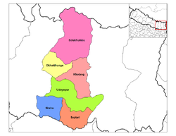
Inner Terai Valleys of Nepal
Encyclopedia
The Inner Terai Valleys or Bhitri tarai (भित्री तराइ) are various elongated valleys in Nepal
situated between the Himalayan foothills, the 600–900 m high Siwalik or Churia Range and the 2,000-3,000 m high Mahabharat Range further north. Major examples are the Chitwan Valley
southwest of Kathmandu and the parallel Dang and Deukhuri Valleys in western Nepal. Similar valleys in India are called Dun or Doon after Dehradun
.
Outer Terai refers to the plains extending south of the Churia or Siwalik Hills bordering India
.
The valleys are low-lying, hot and humid, part of the Himalayan subtropical broadleaf forests
and Terai-Duar savanna and grasslands
ecoregion
s with swamps, grasslands and forests holding a rich variety of plant and animal life. They were virulently malaria
l until suppression with DDT beginning in the 1950s and 1960s enabled intensive settlement that displaced or disenfranchised indigenous people, cleared forests and modified local environments in ways that may threaten biodiversity and contribute to increasingly severe flooding downstream in India and Bangladesh. Nevertheless, the valleys are still areas of great natural beauty with rich ecosystems.
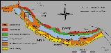
 The Himalayas
were formed by the collision of the Indian sub-continent with Eurasia
, which began about 50 million years ago and continues today. The oceanic crust
in front of India slid under Eurasia, pushing up the Tibetan plateau
. The Indian continental crust
is also pushing under Tibet, but is partly compressed and thrust upward to form the Himalayan mountain range, extending for over 2400 km and rising as high as 8848 m at Mt. Everest Chomolangma.
The Himalayas have four tectonic subdivisions:
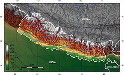
The Inner Terai valleys lie between the Siwalik and Mahabharat ranges or sometimes between different ranges in the Siwaliks. They hold flat plains with winding rivers that shift course from time to time, running northwest or southeast along the axis of the Siwalik ranges until they find a break and flow into the Outer Terai and Gangetic plain. Usually there is little difference in elevation between the Inner Terai valley floors and the plains of the Outer Terai.
 The Terai
has a humid, subtropical climate, warm in the winter and hot (often over 40°C) in the summer. The monsoon
period of torrential rains lasts from mid-June to mid-September. Most areas in the Terai get over 1,500 mm of rain in a year. In the past, the inner and outer Terai were a formidable barrier between Nepal and potential invaders from India because marshes and forests were infested by anopheline mosquitos
that transmitted virulent strains of malaria
, especially during the hot spring and rainy summer monsoon. The Inner Terai is also rich in animal life, including rhinoceros
, tiger
, and reptiles including gharial
and mugger
crocodiles.
Inner Terai valleys were historic strongholds of Tharu, Danuwar and other peoples who had evolved genetic, behavioral and architectural means to resist malaria. Beginning in the 1950s, malaria suppression programs using DDT opened the Inner Terai to settlement by investors from India and the more developed parts of Nepal who introduced modern agricultural methods. Subsistence farmers from the hills where population growth was outstripping finite amounts of cultivable land also arrived. Indigenous terai peoples were largely illiterate and often exploited by moneylenders, losing landholdings and even being reduced to debt bondage.
Both Inner and Outer Terai have become Nepal's richest economic regions, with fertile farms and forests because of the area's generally flat terrain that is drained and nourished by several rivers. The Terai also has the largest commercially exploitable forests.
This has led to concerns about the risk of losing many rare plant, animal and insect species.
The valleys also mitigate the severity of floods on the Gangetic plains. During heavy rainfall forests absorb water. During floods, rivers overflow their banks and flood adjacent forests. Later the forests gradually release water back into the rivers. Deforestation reduces this buffering effect. It also accelerates soil erosion, causing downstream rivers to silt up and overflow their banks.
The frequency and severity of flooding in the Gangetic plain and Bangladesh has steadily increased in recent years. Deforestation of the Terai appears to be one of the major causes. The Indian and Nepalese governments are cooperating in measures including construction of barrages and dams in the Terai, such as the Koshi Barrage
. However, these efforts may have mixed results. They contain floodwater in the short term, but may increase the problem in the longer term by reducing water velocity in the rivers downstream, and thus accelerating silting and reducing the drainage capacity of the rivers.
terrain
satellite
 Imagery of Kamala valley (K):
terrain
satellite
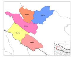
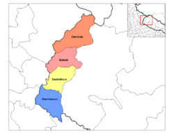
Kamala or Udayapur Valley is in Udayapur district
in the southeast of Nepal (Sketch map). About 30 km long and between 2 km and 4 km wide, it is drained by the Triyuga river flowing east to join the great Koshi
. Kamala Valley lies between the Mahabharat Range to the north and the Churia or Sivalik Hills to the south, with an average elevation of about 430 meters. Gaighat
(or Triyuga
) is the main town.
The mouth of the valley opens onto a 175 km2. rectangle of land where the Triyuga meets the Koshi river above the Koshi Barrage
. It was designated the Koshi Tappu Wildlife Reserve
in 1976, and is home to the last remaining population of Wild Asian Water Buffalo
in Nepal. The reserve is mostly wetlands, subject to seasonal flooding, but also includes some grasslands and small patches of riverine forest. It is the only Ramsar Site (a wetland of international significance) in Nepal.
Traditionally, the Kamala valley was primarily inhabited by the Dhanwar people (or Danuwar), but there is a fast-growing population of migrants from the Nepali hills and from India.
 Imagery of Marin Khola (M):
terrain
satellite
The Marin Khola Valley is one of the smaller Inner Terai Valleys, in the central south region, Sindhulī Garhi district
. (Sketch Map) Three streams – Kokhajor Khola, Marin Khola and Kyan Khola – join in the valley to form Kamala River
, a major tributary to the Bhurengi..
The main town is Kamalamai
.
The Indian government is concerned about flooding from the Kamala and is funding engineering projects to mitigate risks.
Marin Khola Valley is inhabited by Hayu
people, who also live along the Rosi Khola and Sun Kosi River north of the Mahabharat Range.
 Imagery of Chitwan (C):
terrain
satellite
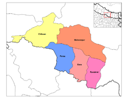
Chitwan Valley is in central Nepal in Narayani Zone
. It is 150 km long and roughly 30-48 km wide, the largest of Nepal's inner Terai valleys. (Sketch Map) The cities Bharatpur
, Hetauda
and Ratnanagar
are in the valley. It is drained by the (East) Rapti river flowing from the Mahabharat Range near Hetauda, then west down the valley to join the Narayani west of Meghauli
. The Narayani is also called Gandaki further upstream and Gandak in India.
Chitwan National Park is one of the most important sub-tropical parks on the Indian subcontinent. It has good populations of the endangered Bengal tiger
, great one-horned rhinos
, gangetic dolphin, wild Asian elephant
, gaur
, golden monitor lizard
and gharial
crocodile. In 1963 the southern two-thirds of the park were declared a Rhino Sanctuary, with a moratorium on hunting and the relocation of 22,000 people from the Chitwan valley. Since then, wildlife populations and ecosystems have rebounded. In 1973 Chitwan became Nepal’s first National Park. UNESCO
declared the park a World Heritage site in 1984.
satellite
 Imagery of Dang (A) and Deukhuri (E):
terrain satellite
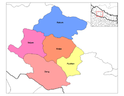
Parallel Dang Valley and Deukhuri Valley are in Rapti Zone
of mid-western Nepal, in Dang Deokhuri
district (Sketch map). Both valleys have large Tharu populations and are used as winter pasture by Kham Magar
from the hills.
Deukhuri Valley is the longer but narrower valley where the West Rapti River
emerges from its gorge through the Mahabharat Range and is constrained to flow WNW along the axis of the Siwalik Range between the Dundwa subrange along the India border and the Dang subrange to the north. It flows 100 km in this direction until the Dundwas fall away near Nepalganj and the river can resume flowing SE toward the Ganges. Mahendra Highway
crossing Nepal east to west follows Deukhuri Valley.
. The low surrounding mountains, the river, the jungle interspersed with fields and distinctive ethnic groups gave Deukhuri a timeless Garden of Eden
quality that development brought by the highway may now be diminishing.
The wider Dang valley lies north of Deukhuri between the Dang subrange and the higher Mahabharat or Lesser Himalayan Range further north. Tulsipur has a fair-weather airport and is the administrative center of Rapti Zone. Tribhuvannagar
(or Ghorahi) is a sizeable bazaar and the administrative center of Dang District. The Babai River drains the valley, also flowing WNW along the Siwalik axis. It finally exits the Siwaliks at Bardia National Park. (Map). This park is the largest and most undisturbed wilderness area in the Terai. About 70% of the park is covered with forest with the balance a mixture of grassland, savannah and riverine forest.
 Imagery of Surkhet (S):
terrain
satellite
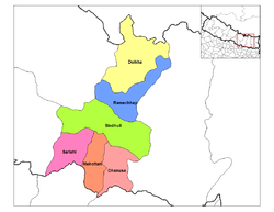
Surkhet Valley is in the mid-west of Nepal, in Surkhet district
(Sketch map). The valley is about 700 meters above sea level, an ellipse about 9 km east-west by 6 km north-south. It is drained by the Bheri River
, a tributary of the Karnali. Historically Tharu and local Rajhi people populated the valley. In recent decades there has been increased migration from surrounding mountain districts as well as other parts of the country. Birendranagar
is the district's main population center.
 Imagery of Jogbudha valley (J):
terrain
satellite
Jogbudha Valley is in the far west of Nepal, in Dadeldhura district
of Mahakali zone
(Sketch map). Streams of this relatively small and undeveloped valley empty into the Mahakali or Sarda River
which rises in the high Himalaya and defines most of Nepal's western border with Uttarakhand
, India.
In the outer Terai south of this valley is Sukla Phanta Wildlife Reserve
, home of the largest herd of Swamp Deer
in the world. In 1984 UNESCO listed it as a World Heritage Site.
Nepal
Nepal , officially the Federal Democratic Republic of Nepal, is a landlocked sovereign state located in South Asia. It is located in the Himalayas and bordered to the north by the People's Republic of China, and to the south, east, and west by the Republic of India...
situated between the Himalayan foothills, the 600–900 m high Siwalik or Churia Range and the 2,000-3,000 m high Mahabharat Range further north. Major examples are the Chitwan Valley
Chitwan Valley
Chitwan Valley is an Inner Terai valley in the south of Nepal, encompassing the districts of Makwanpur, Chitwan and Nawalparasi. The valley is part of the Terai-Duar savanna and grasslands ecoregion of about 150 km length and 30–48 km width....
southwest of Kathmandu and the parallel Dang and Deukhuri Valleys in western Nepal. Similar valleys in India are called Dun or Doon after Dehradun
Dehradun
- Geography :The Dehradun district has various types of physical geography from Himalayan mountains to Plains. Raiwala is the lowest point at 315 meters above sea level, and the highest points are within the Tiuni hills, rising to 3700 m above sea level...
.
Outer Terai refers to the plains extending south of the Churia or Siwalik Hills bordering India
India
India , officially the Republic of India , is a country in South Asia. It is the seventh-largest country by geographical area, the second-most populous country with over 1.2 billion people, and the most populous democracy in the world...
.
The valleys are low-lying, hot and humid, part of the Himalayan subtropical broadleaf forests
Himalayan subtropical broadleaf forests
The Himalayan subtropical broadleaf forests is an ecoregion that extends from the middle hills of central Nepal through Darjeeling into Bhutan and also into the Indian State of Uttar Pradesh...
and Terai-Duar savanna and grasslands
Terai-Duar savanna and grasslands
The Terai-Duar savanna and grasslands is a narrow lowland ecoregion at the base of the Himalayas, about wide and a continuation of the Gangetic Plain colloquially called Terai in the Ganges Basin east to Nepal, then Dooars in West Bengal, Bangladesh, Bhutan and Assam east to the Brahmaputra River...
ecoregion
Ecoregion
An ecoregion , sometimes called a bioregion, is an ecologically and geographically defined area that is smaller than an ecozone and larger than an ecosystem. Ecoregions cover relatively large areas of land or water, and contain characteristic, geographically distinct assemblages of natural...
s with swamps, grasslands and forests holding a rich variety of plant and animal life. They were virulently malaria
Malaria
Malaria is a mosquito-borne infectious disease of humans and other animals caused by eukaryotic protists of the genus Plasmodium. The disease results from the multiplication of Plasmodium parasites within red blood cells, causing symptoms that typically include fever and headache, in severe cases...
l until suppression with DDT beginning in the 1950s and 1960s enabled intensive settlement that displaced or disenfranchised indigenous people, cleared forests and modified local environments in ways that may threaten biodiversity and contribute to increasingly severe flooding downstream in India and Bangladesh. Nevertheless, the valleys are still areas of great natural beauty with rich ecosystems.
Geology
Himalayas
The Himalaya Range or Himalaya Mountains Sanskrit: Devanagari: हिमालय, literally "abode of snow"), usually called the Himalayas or Himalaya for short, is a mountain range in Asia, separating the Indian subcontinent from the Tibetan Plateau...
were formed by the collision of the Indian sub-continent with Eurasia
Eurasia
Eurasia is a continent or supercontinent comprising the traditional continents of Europe and Asia ; covering about 52,990,000 km2 or about 10.6% of the Earth's surface located primarily in the eastern and northern hemispheres...
, which began about 50 million years ago and continues today. The oceanic crust
Oceanic crust
Oceanic crust is the part of Earth's lithosphere that surfaces in the ocean basins. Oceanic crust is primarily composed of mafic rocks, or sima, which is rich in iron and magnesium...
in front of India slid under Eurasia, pushing up the Tibetan plateau
Tibetan Plateau
The Tibetan Plateau , also known as the Qinghai–Tibetan Plateau is a vast, elevated plateau in Central Asia covering most of the Tibet Autonomous Region and Qinghai, in addition to smaller portions of western Sichuan, southwestern Gansu, and northern Yunnan in Western China and Ladakh in...
. The Indian continental crust
Continental crust
The continental crust is the layer of igneous, sedimentary, and metamorphic rocks which form the continents and the areas of shallow seabed close to their shores, known as continental shelves. This layer is sometimes called sial due to more felsic, or granitic, bulk composition, which lies in...
is also pushing under Tibet, but is partly compressed and thrust upward to form the Himalayan mountain range, extending for over 2400 km and rising as high as 8848 m at Mt. Everest Chomolangma.
The Himalayas have four tectonic subdivisions:
- The Indus Suture Zone, where the Indian Plate meets the Eurasian Transhimalaya or Karakoram-Lhasa Block.
- The Central Himalayan Domain, the high backbone of the Himalayas bounded on the south by a fault zone called the MCT (Main Central Thrust) that has elevated these peaks three or four thousand meters above lower ranges to the south.
- The "middle hills" below the MCT south to the Lesser Himalaya or Mahabharat Range which is bounded by another fault zone, the MBT (Main Boundary Thrust) that abruptly elevates the Mahabharats 1,000 to 2,000 meters above hills further south.
- The Subhimalaya also known as the Muree, Chure Hills or Siwaliks, which are the southernmost foothills of the Himalayan Range and mainly composed of folded and overlapping sheets of sediment from the erosion of the Himalaya. They are bounded on the south by the HFT (Himalayan Frontal Thrust) elevating them about 500 meters above the Gangetic plain.
The Inner Terai valleys lie between the Siwalik and Mahabharat ranges or sometimes between different ranges in the Siwaliks. They hold flat plains with winding rivers that shift course from time to time, running northwest or southeast along the axis of the Siwalik ranges until they find a break and flow into the Outer Terai and Gangetic plain. Usually there is little difference in elevation between the Inner Terai valley floors and the plains of the Outer Terai.
Climate and economy
Terai
The Terai is a belt of marshy grasslands, savannas, and forests located south of the outer foothills of the Himalaya, the Siwalik Hills, and north of the Indo-Gangetic Plain of the Ganges, Brahmaputra and their tributaries. The Terai belongs to the Terai-Duar savanna and grasslands ecoregion...
has a humid, subtropical climate, warm in the winter and hot (often over 40°C) in the summer. The monsoon
Monsoon
Monsoon is traditionally defined as a seasonal reversing wind accompanied by corresponding changes in precipitation, but is now used to describe seasonal changes in atmospheric circulation and precipitation associated with the asymmetric heating of land and sea...
period of torrential rains lasts from mid-June to mid-September. Most areas in the Terai get over 1,500 mm of rain in a year. In the past, the inner and outer Terai were a formidable barrier between Nepal and potential invaders from India because marshes and forests were infested by anopheline mosquitos
Anopheles
Anopheles is a genus of mosquito. There are approximately 460 recognized species: while over 100 can transmit human malaria, only 30–40 commonly transmit parasites of the genus Plasmodium, which cause malaria in humans in endemic areas...
that transmitted virulent strains of malaria
Malaria
Malaria is a mosquito-borne infectious disease of humans and other animals caused by eukaryotic protists of the genus Plasmodium. The disease results from the multiplication of Plasmodium parasites within red blood cells, causing symptoms that typically include fever and headache, in severe cases...
, especially during the hot spring and rainy summer monsoon. The Inner Terai is also rich in animal life, including rhinoceros
Indian Rhinoceros
The Indian Rhinoceros is also called Greater One-horned Rhinoceros and Asian One-horned Rhinoceros and belongs to the Rhinocerotidae family...
, tiger
Tiger
The tiger is the largest cat species, reaching a total body length of up to and weighing up to . Their most recognizable feature is a pattern of dark vertical stripes on reddish-orange fur with lighter underparts...
, and reptiles including gharial
Gharial
The gharial , , also called Indian gavial or gavial, is the only surviving member of the once well-represented family Gavialidae, a long-established group of crocodilians with long, slender snouts...
and mugger
Mugger Crocodile
The mugger crocodile , also called the Indian, Indus, Persian, or marsh crocodile, is found throughout the Indian subcontinent and the surrounding countries...
crocodiles.
Inner Terai valleys were historic strongholds of Tharu, Danuwar and other peoples who had evolved genetic, behavioral and architectural means to resist malaria. Beginning in the 1950s, malaria suppression programs using DDT opened the Inner Terai to settlement by investors from India and the more developed parts of Nepal who introduced modern agricultural methods. Subsistence farmers from the hills where population growth was outstripping finite amounts of cultivable land also arrived. Indigenous terai peoples were largely illiterate and often exploited by moneylenders, losing landholdings and even being reduced to debt bondage.
Both Inner and Outer Terai have become Nepal's richest economic regions, with fertile farms and forests because of the area's generally flat terrain that is drained and nourished by several rivers. The Terai also has the largest commercially exploitable forests.
Environmental Issues
The well-meaning malaria eradication campaign has had unexpected consequences by opening up the Terai region to human settlement. The Inner Terai valleys are home to a rich and diverse ecosystem. Since the early 1990s, however, the forests have been increasingly destroyed because of growing demands for timber and agricultural landThis has led to concerns about the risk of losing many rare plant, animal and insect species.
The valleys also mitigate the severity of floods on the Gangetic plains. During heavy rainfall forests absorb water. During floods, rivers overflow their banks and flood adjacent forests. Later the forests gradually release water back into the rivers. Deforestation reduces this buffering effect. It also accelerates soil erosion, causing downstream rivers to silt up and overflow their banks.
The frequency and severity of flooding in the Gangetic plain and Bangladesh has steadily increased in recent years. Deforestation of the Terai appears to be one of the major causes. The Indian and Nepalese governments are cooperating in measures including construction of barrages and dams in the Terai, such as the Koshi Barrage
Koshi Barrage
The Koshi Barrage is a flood control sluice across the Koshi River at the Nepal–Indian border. It was built between 1958 and 1962.The Koshi Tappu Wildlife Reserve is several miles north of the Barrage.- 2008 flood :...
. However, these efforts may have mixed results. They contain floodwater in the short term, but may increase the problem in the longer term by reducing water velocity in the rivers downstream, and thus accelerating silting and reducing the drainage capacity of the rivers.
Valleys
This section describes the major Inner Terai valleys. A picture is worth a thousand words. Click on the terrain and satellite imagery links to see vegetation, rivers, topography, roads and towns.Central and Eastern Terai
Imagery with markers at valleys Kamala (K), Marin Khola (M) and Chitwan (C)terrain
satellite
Kamala Valley
terrain
satellite
Kamala or Udayapur Valley is in Udayapur district
Udayapur District
-Village Development Committees :*Aaptar*Balamta*Baraha*Barre*Basabote*Bashasa*Beltar*Bhumarashuwa*Bhuttar*Chaudandi*Dumre*Gaighat*Hadiya*Hardeni*Iname*Jalpachilaune*Jante*Jogidaha*Katari*Katunjebawala*Khanbu*Laphagaun*Lekhani*Lekhgaun...
in the southeast of Nepal (Sketch map). About 30 km long and between 2 km and 4 km wide, it is drained by the Triyuga river flowing east to join the great Koshi
Koshi River
The Kosi River or Koshi —also Saptakoshi for its seven Himalayan tributaries—is a trans-boundary river flowing through Nepal and India. Some of the rivers of the Koshi system, such as the Arun, the Sun Kosi and the Bhote Koshi, originate in the Tibet Autonomous Region of China...
. Kamala Valley lies between the Mahabharat Range to the north and the Churia or Sivalik Hills to the south, with an average elevation of about 430 meters. Gaighat
Gaighat
Gaighat is a town in east Nepal. It is situated in a valley and surrounded by the Chure Hills. Many different ethnic groups and castes live in Gaighat, following their old traditions and speaking many languages. As a trade focal point of the Udayapur District, this place has an emerging number...
(or Triyuga
Triyuga
Triyuga is a city and municipality in the Udayapur District in the Sagarmatha zone of south-eastern Nepal. According to the 1991 Nepal census, it had a population of 55,291.-Geography and wildlife:...
) is the main town.
The mouth of the valley opens onto a 175 km2. rectangle of land where the Triyuga meets the Koshi river above the Koshi Barrage
Kosi embankment
The Kosi embankments were built in late 1950s to retain the Kosi River which is a transboundary river between Nepal and India and is one of the largest tributaries of the Ganges....
. It was designated the Koshi Tappu Wildlife Reserve
Koshi Tappu Wildlife Reserve
The Koshi Tappu Wildlife Reserve is a protected area in the Terai of eastern Nepal covering of wetlands in the Sunsari, Saptari and Udayapur Districts. In altitude it ranges from and consists of extensive mudflats, reed beds, and freshwater marshes in the floodplain of the Sapta Kosi River...
in 1976, and is home to the last remaining population of Wild Asian Water Buffalo
Wild Asian Water Buffalo
The wild water buffalo also called Asian buffalo and Asiatic buffalo is a large bovine native to Southeast Asia...
in Nepal. The reserve is mostly wetlands, subject to seasonal flooding, but also includes some grasslands and small patches of riverine forest. It is the only Ramsar Site (a wetland of international significance) in Nepal.
Traditionally, the Kamala valley was primarily inhabited by the Dhanwar people (or Danuwar), but there is a fast-growing population of migrants from the Nepali hills and from India.
Marin Khola Valley
terrain
satellite
The Marin Khola Valley is one of the smaller Inner Terai Valleys, in the central south region, Sindhulī Garhi district
Sindhuli District
-Historical Importance:This place has a huge historic significance. The Sindhuli Gadhi in Sindhuli is the place where British soldiers were defeated for the first time in Asia in 1767 A.D . The British under the leadership of Captain Kinloch came to help the then ruler of Kathmandu, Jai Prakash...
. (Sketch Map) Three streams – Kokhajor Khola, Marin Khola and Kyan Khola – join in the valley to form Kamala River
Kamala River
The Kamala River flows through Nepal and the Indian state of Bihar.-Course:The Kamala originates from Mahabharat Range near Sindhuliagarhi in Sindhuli District of Nepal at an elevation of .It flows in a southerly direction and after passing through a gorge above Chauphat it flows into the terai...
, a major tributary to the Bhurengi..
The main town is Kamalamai
Kamalamai
Kamalamai is a municipality in Sindhuli District, in the Janakpur zone of central south Nepal. At the time of the 1991 Nepal census it had a population of 32,838 people....
.
The Indian government is concerned about flooding from the Kamala and is funding engineering projects to mitigate risks.
Marin Khola Valley is inhabited by Hayu
Hayu
The Hayus are a member of the Kirant tribe speaking their own language, Wayu or Hayu. Little is known about them. They are Animist by religion. According to the 2001 Nepal census, there are 1821 Hayu in the country,of which 70.29% were Hindus and 23.61% were animists.- External links :* *...
people, who also live along the Rosi Khola and Sun Kosi River north of the Mahabharat Range.
Chitwan Valley
terrain
satellite
Chitwan Valley is in central Nepal in Narayani Zone
Narayani Zone
- Geography :Narayani contains parts of the Terai, Inner Terai, and Hill regions of Nepal, but it does not contain any of the Mountain or Himalayan region. Narayani is rich in flora and fauna...
. It is 150 km long and roughly 30-48 km wide, the largest of Nepal's inner Terai valleys. (Sketch Map) The cities Bharatpur
Bharatpur, Nepal
Bharatpur is a city in the central-southern part of Nepal. Located in Chitwan Valley, Bharatpur is the district headquarters of the Chitwan District, as well as a separate Municipal authority, and is the seventh largest city of Nepal with the population of 89,323 . The estimated population for...
, Hetauda
Hetauda
Hetauda is a town in the Makwanpur District of the Narayani Zone in southern Nepal. It is also the administrative headquarters of the Makwanpur district. At the time of the 1991 Nepal census it had a population of 53,836 people living in 10,420 individual households...
and Ratnanagar
Ratnanagar
Ratnanagar is a Municipality in Chitwan District of Nepal. It is the second municipality in the district. Tandi is the major city in the this municipality. It is adjacent to Chitwan National Park, and serves as a gateway to the park....
are in the valley. It is drained by the (East) Rapti river flowing from the Mahabharat Range near Hetauda, then west down the valley to join the Narayani west of Meghauli
Meghauli
Meghauli is a village development committee in Chitwan District in the Narayani Zone of southern Nepal. At the time of the 1991 Nepal census it had a population of 12,281 people living in 2027 individual households....
. The Narayani is also called Gandaki further upstream and Gandak in India.
Chitwan National Park is one of the most important sub-tropical parks on the Indian subcontinent. It has good populations of the endangered Bengal tiger
Bengal Tiger
The Bengal tiger is a tiger subspecies native to the Indian subcontinent that in 2010 has been classified as endangered by IUCN...
, great one-horned rhinos
Indian Rhinoceros
The Indian Rhinoceros is also called Greater One-horned Rhinoceros and Asian One-horned Rhinoceros and belongs to the Rhinocerotidae family...
, gangetic dolphin, wild Asian elephant
Asian Elephant
The Asian or Asiatic elephant is the only living species of the genus Elephas and distributed in Southeast Asia from India in the west to Borneo in the east. Three subspecies are recognized — Elephas maximus maximus from Sri Lanka, the Indian elephant or E. m. indicus from mainland Asia, and E. m....
, gaur
Gaur
The gaur , also called Indian bison, is a large bovine native to South Asia and Southeast Asia. The species is listed as vulnerable on the IUCN Red List since 1986 as the population decline in parts of the species' range is likely to be well over 70% over the last three generations...
, golden monitor lizard
Monitor lizard
Monitor lizards are usually large reptiles, although some can be as small as in length. They have long necks, powerful tails and claws, and well-developed limbs. Most species are terrestrial, but arboreal and semiaquatic monitors are also known...
and gharial
Gharial
The gharial , , also called Indian gavial or gavial, is the only surviving member of the once well-represented family Gavialidae, a long-established group of crocodilians with long, slender snouts...
crocodile. In 1963 the southern two-thirds of the park were declared a Rhino Sanctuary, with a moratorium on hunting and the relocation of 22,000 people from the Chitwan valley. Since then, wildlife populations and ecosystems have rebounded. In 1973 Chitwan became Nepal’s first National Park. UNESCO
UNESCO
The United Nations Educational, Scientific and Cultural Organization is a specialized agency of the United Nations...
declared the park a World Heritage site in 1984.
Western Terai
Imagery of western Terai. Markers at valleys Jogbudha (J), Surkhet (S), Dang (A) and Deukhuri (E) terrainsatellite
Dang and Deukhuri Valleys
terrain satellite
Parallel Dang Valley and Deukhuri Valley are in Rapti Zone
Rapti Zone
Rapti Anchal in the Mid-Western Development Region of Nepal. It is named after the West Rapti River which drains Rolpa, Pyuthan and part of Dang district. The remainder of Dang and part of Salyan are drained by the Babai. The remainder of Salyan and all of Rukum are drained by the Bheri.The...
of mid-western Nepal, in Dang Deokhuri
Dang Deokhuri District
Dang-Deukhuri, District is an Inner Terai district some 280 km west of Kathmandu in Rapti Zone of Nepal's Mid-Western Region. Dang-Deukhuri covers an area of 2,955 km² with population of 462,380...
district (Sketch map). Both valleys have large Tharu populations and are used as winter pasture by Kham Magar
Kham Magar
Kham Magar and Northern Magar are descriptive terms invented by academic linguists and anthropologists for a nationality in the Middle Hills of mid-western Nepal inhabiting highlands extending through eastern Rukum and northern Salyan, Rolpa and Pyuthan Districts in Rapti Zone as well as adjacent...
from the hills.
Deukhuri Valley is the longer but narrower valley where the West Rapti River
West Rapti River
Not to be confused with the East Rapti in Chitwan Valley some to the east, this Rapti drains Rapti Zone in Mid-Western Region, Nepal, then Awadh and Purvanchal regions of Uttar Pradesh state, India before joining the Ghaghara a major left bank tributary of the Ganges.The West Rapti is notable for...
emerges from its gorge through the Mahabharat Range and is constrained to flow WNW along the axis of the Siwalik Range between the Dundwa subrange along the India border and the Dang subrange to the north. It flows 100 km in this direction until the Dundwas fall away near Nepalganj and the river can resume flowing SE toward the Ganges. Mahendra Highway
Mahendra Highway
Mahendra Highway also called East West Highway runs across the Terai region of Nepal, from Kankarbhitta in the east to Mahendranagar in the west, cutting across the entire width of the country. It is the longest highway in Nepal.-Overview:...
crossing Nepal east to west follows Deukhuri Valley.
. The low surrounding mountains, the river, the jungle interspersed with fields and distinctive ethnic groups gave Deukhuri a timeless Garden of Eden
Garden of Eden
The Garden of Eden is in the Bible's Book of Genesis as being the place where the first man, Adam, and his wife, Eve, lived after they were created by God. Literally, the Bible speaks about a garden in Eden...
quality that development brought by the highway may now be diminishing.
The wider Dang valley lies north of Deukhuri between the Dang subrange and the higher Mahabharat or Lesser Himalayan Range further north. Tulsipur has a fair-weather airport and is the administrative center of Rapti Zone. Tribhuvannagar
Tribhuvannagar
Tribhuvan Nagar, renamed as Ghorahi is a municipality of Dang Valley, Dang Deokhuri District of Rapti Zone, southwest Nepal.Tribhuvannagar can be reached by the road that goes 23 kilometers North from Lamahi, a small town on the Mahendra highway....
(or Ghorahi) is a sizeable bazaar and the administrative center of Dang District. The Babai River drains the valley, also flowing WNW along the Siwalik axis. It finally exits the Siwaliks at Bardia National Park. (Map). This park is the largest and most undisturbed wilderness area in the Terai. About 70% of the park is covered with forest with the balance a mixture of grassland, savannah and riverine forest.
Surkhet Valley
terrain
satellite
Surkhet Valley is in the mid-west of Nepal, in Surkhet district
Surkhet District
-Village Development Committees :*Agragaun*Awalaching*Babiyachaur*Bajedichaur*Betan*Bidyapur*Bijaura*Birendranagar*Chapre*Chhinchu*Dahachaur*Dandakhali*Dasarathpur*Dharapani*Gadi...
(Sketch map). The valley is about 700 meters above sea level, an ellipse about 9 km east-west by 6 km north-south. It is drained by the Bheri River
Bheri River
The Bheri River is a major tributary of the Karnali River draining the western Dhaulagiri range in western Nepal. It has three important upper tributaries. Sani Bheri drains southern slopes of this range while Thuli Bheri drains northern slopes. Another tributary Uttar Ganga drains Dhorpatan...
, a tributary of the Karnali. Historically Tharu and local Rajhi people populated the valley. In recent decades there has been increased migration from surrounding mountain districts as well as other parts of the country. Birendranagar
Birendranagar
Birendranagar is a city in mid western Nepal, located in the Surkhet District of Bheri Zone. At the time of the 1991 Nepal census it had a population of 22,937 people residing in 4773 individual households....
is the district's main population center.
Jogbudha Valley
terrain
satellite
Jogbudha Valley is in the far west of Nepal, in Dadeldhura district
Dadeldhura District
Dadeldhura district, a part of Mahakali zone, is one of the seventy-five districts of Nepal, a landlocked country of South Asia. The district, with Dadeldhura as its district headquarters, covers an area of 1,538km² and has a population of 126,162....
of Mahakali zone
Mahakali Zone
Mahakali|Kali River]] or Mahakali River, which originates from Kalapani.Mahakali's headquarter is Mahendranagar in Kanchanpur District. The zone covers the Himalayan range including Api Peak in the North, Hill valleys, Inner Terai valleys such as Patan in Baitadi District in the center and the...
(Sketch map). Streams of this relatively small and undeveloped valley empty into the Mahakali or Sarda River
Sarda River
Sarda River forms part of the border between the nations of India and Nepal. It is called the Mahakali River in Nepal and Kali Gad by local pahari people . This boundary was established by the 1816 Sugauli treaty, but a portion of this border near China has been in dispute...
which rises in the high Himalaya and defines most of Nepal's western border with Uttarakhand
Uttarakhand
Uttarakhand , formerly Uttaranchal, is a state in the northern part of India. It is often referred to as the Land of Gods due to the many holy Hindu temples and cities found throughout the state, some of which are among Hinduism's most spiritual and auspicious places of pilgrimage and worship...
, India.
In the outer Terai south of this valley is Sukla Phanta Wildlife Reserve
Sukla Phanta Wildlife Reserve
Sukla Phanta Wildlife Reserve is a protected area in the Terai of the Far-Western Region, Nepal, covering of open grassland, forests, riverbeds and tropical wetlands at an altitude of . It was gazetted in 1973 as Royal Sukla Phanta Wildlife Reserve...
, home of the largest herd of Swamp Deer
Barasingha
The Barasingha or Swamp deer is a deer species currently found in isolated localities in north and central India, and southwestern Nepal, and is extinct in Pakistan and Bangladesh....
in the world. In 1984 UNESCO listed it as a World Heritage Site.