
Dhaulagiri
Encyclopedia
Dhaulagiri is Earth's seventh highest mountain
at 8167 metres (26,795 ft); one of fourteen over eight thousand metres
. Dhaulagiri was first climbed May 13, 1960 by a Swiss/Austrian expedition.
The mountain's name is धौलागिरी (dhaulāgirī) or धवलागिरी (dhawalāgirī) in Hindi
and Nepali
. This comes from Sanskrit
where धवल (dhawala) means dazzling, white, beautiful and गिरि (giri) means mountain. It is often called Dhaulagiri I, denoting the highest summit
in its massif
called Dhaulagiri Range , Dhaulagiri Himāl or The Dhaulagiris. This massif extends 120 km from the Kali Gandaki River west to the Bheri
. Dhaulagiri I is the easternmost high peak. Dhaulagiri I is also the highest point of the Gandaki river basin.
Annapurna I
(8,091m/26,545ft) is only 34 km. east of Dhaulagiri I. The Kaligandaki River flows between through its notable gorge
, said to be the world's deepest. The town Pokhara
is south of the Annapurnas, an important regional center and the gateway for climbers and trekkers
visiting both ranges as well as a tourist destination in its own right.
and as far south as Gorakhpur in Uttar Pradesh
. In 1808 A.D. survey computations
showed it to be the highest mountain yet surveyed. This lasted until 1838 when Kangchenjunga
took its place, followed by Mount Everest
in 1858.
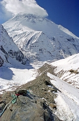
Dhaulagiri's sudden rise from lower terrain is almost unequaled. It rises 7,000 metres from the Kali Gandaki River 30 km to the southeast. The South and West faces rise precipitously over 4000 metres. The south face of Gurja Himal in the same massif is also notably immense.
 Most ascents have followed the Northeast Ridge route of the first ascent, but climbs have been made from most directions. As of 2007 there had been 358 successful ascents and 58 fatalities. Between 1950 and 2006, 2.88% of 2,016 expedition members and staff going above base camp on Dhaulagiri I died. On all 8,000 metre peaks in Nepal the death rate was 1.63%, ranging from 0.65% on Cho Oyu
to 4.04% on Annapurna I and 3.05% on Manaslu
.
† Only peaks above 7,200 m with more than 500 m (1,640 ft) of topographic prominence
are ranked.
‡ The status of Churen Himal's three peaks is unclear and sources differ on their heights. The coordinates, heights and prominence values above are derived from the Finnmap. The first ascent data is from Neate, but it is unclear if the first ascent of Churen Himal East was actually an ascent of the highest of the three peaks, as Neate lists Churen Himal Central as a 7,320 m subpeak of Churen Himal East.
Most of the named 7,000 metre peaks are on a ridge extending WNW, separated from Dhaulagiri I by 5,355m French Pass at 28°46'55"N, 83°31'54"E. In order they are Dhaulagiri II, III, V, IV, Junction Peak, Churens East, Central and West, then Putha Hiunchuli. False Junction Peak, Dhaulagiri VI and Gurja are on a ridge extending south from Junction Peak. The British Alpine Club's Himalayan Index lists 37 more peaks over 6,000 m.
Mountain
Image:Himalaya_annotated.jpg|thumb|right|The Himalayan mountain range with Mount Everestrect 58 14 160 49 Chomo Lonzorect 200 28 335 52 Makalurect 378 24 566 45 Mount Everestrect 188 581 920 656 Tibetan Plateaurect 250 406 340 427 Rong River...
at 8167 metres (26,795 ft); one of fourteen over eight thousand metres
Eight-thousander
The eight-thousanders are the fourteen independent mountains on Earth that are more than high above sea level. They are all located in the Himalayan and Karakoram mountain ranges in Asia....
. Dhaulagiri was first climbed May 13, 1960 by a Swiss/Austrian expedition.
The mountain's name is धौलागिरी (dhaulāgirī) or धवलागिरी (dhawalāgirī) in Hindi
Hindi
Standard Hindi, or more precisely Modern Standard Hindi, also known as Manak Hindi , High Hindi, Nagari Hindi, and Literary Hindi, is a standardized and sanskritized register of the Hindustani language derived from the Khariboli dialect of Delhi...
and Nepali
Nepali language
Nepali or Nepalese is a language in the Indo-Aryan branch of the Indo-European language family.It is the official language and de facto lingua franca of Nepal and is also spoken in Bhutan, parts of India and parts of Myanmar...
. This comes from Sanskrit
Sanskrit
Sanskrit , is a historical Indo-Aryan language and the primary liturgical language of Hinduism, Jainism and Buddhism.Buddhism: besides Pali, see Buddhist Hybrid Sanskrit Today, it is listed as one of the 22 scheduled languages of India and is an official language of the state of Uttarakhand...
where धवल (dhawala) means dazzling, white, beautiful and गिरि (giri) means mountain. It is often called Dhaulagiri I, denoting the highest summit
Summit
Summit may refer to:*Summit , the highest point of a mountain, hill, road, or railway.-Locations:United States* Summit, Arizona* Summit, Arkansas* Summit, California** Summit, Butte County, California** Summit, Kern County, California...
in its massif
Massif
In geology, a massif is a section of a planet's crust that is demarcated by faults or flexures. In the movement of the crust, a massif tends to retain its internal structure while being displaced as a whole...
called Dhaulagiri Range , Dhaulagiri Himāl or The Dhaulagiris. This massif extends 120 km from the Kali Gandaki River west to the Bheri
Bheri River
The Bheri River is a major tributary of the Karnali River draining the western Dhaulagiri range in western Nepal. It has three important upper tributaries. Sani Bheri drains southern slopes of this range while Thuli Bheri drains northern slopes. Another tributary Uttar Ganga drains Dhorpatan...
. Dhaulagiri I is the easternmost high peak. Dhaulagiri I is also the highest point of the Gandaki river basin.
Annapurna I
Annapurna
Annapurna is a section of the Himalayas in north-central Nepal that includes Annapurna I, thirteen additional peaks over and 16 more over ....
(8,091m/26,545ft) is only 34 km. east of Dhaulagiri I. The Kaligandaki River flows between through its notable gorge
Kali Gandaki Gorge
The Kali Gandaki Gorge or Andha Galchi is the gorge of the Kali Gandaki in the Himalayas in Nepal, by some measures the deepest gorge in the world....
, said to be the world's deepest. The town Pokhara
Pokhara
Pokhara Sub-Metropolitan City is the second largest city of Nepal. Pokhara is city of close to 350,000 inhabitants in central Nepal located at 28.25°N, 83.99°E, which is the centre of the country from east to west or from north to south, 198 km west of Kathmandu or 90 km west of Mugling, and...
is south of the Annapurnas, an important regional center and the gateway for climbers and trekkers
Trek
Trek or trekking is a long journey undertaken on foot in areas where common means of transport is generally not available. Trekking is not mountaineering; it is days of walking along with adventure.-Etymology:...
visiting both ranges as well as a tourist destination in its own right.
Geographic History
Looking north from the plains of India, most 8,000 metre peaks are obscured by nearer mountains, but in clear weather Dhaulagiri is conspicuous from northern BiharBihar
Bihar is a state in eastern India. It is the 12th largest state in terms of geographical size at and 3rd largest by population. Almost 58% of Biharis are below the age of 25, which is the highest proportion in India....
and as far south as Gorakhpur in Uttar Pradesh
Uttar Pradesh
Uttar Pradesh abbreviation U.P. , is a state located in the northern part of India. With a population of over 200 million people, it is India's most populous state, as well as the world's most populous sub-national entity...
. In 1808 A.D. survey computations
Great Trigonometric Survey
The Great Trigonometric Survey was a project of the Survey of India throughout most of the 19th century. It was piloted in its initial stages by William Lambton, and later by George Everest. Among the many accomplishments of the Survey were the demarcation of the British territories in India and...
showed it to be the highest mountain yet surveyed. This lasted until 1838 when Kangchenjunga
Kangchenjunga
Kangchenjunga is the third highest mountain of the world with an elevation of and located along the India-Nepal border in the Himalayas.Kangchenjunga is also the name of the section of the Himalayas and means "The Five Treasures of Snows", as it contains five peaks, four of them over...
took its place, followed by Mount Everest
Mount Everest
Mount Everest is the world's highest mountain, with a peak at above sea level. It is located in the Mahalangur section of the Himalayas. The international boundary runs across the precise summit point...
in 1858.
Dhaulagiri's sudden rise from lower terrain is almost unequaled. It rises 7,000 metres from the Kali Gandaki River 30 km to the southeast. The South and West faces rise precipitously over 4000 metres. The south face of Gurja Himal in the same massif is also notably immense.
Dhaulagiri I Climbing History
Cho Oyu
Cho Oyu is the sixth highest mountain in the world at above sea level. Cho Oyu lies in the Himalayas and is 20 km west of Mount Everest, at the border between China and Nepal...
to 4.04% on Annapurna I and 3.05% on Manaslu
Manaslu
Manaslu , also known as Kutang) is the eighth highest mountain in the world, and is located in the Mansiri Himal, part of the Nepalese Himalayas, in the west-central part of Nepal. Its name, which means "Mountain of the Spirit", comes from the Sanskrit word Manasa, meaning "intellect" or "soul"...
.
Partial timeline
- 1950 – Dhaulagiri I reconnoitered by a French expedition led by Maurice HerzogMaurice HerzogMaurice Herzog is a French mountaineer and sports administrator who was born in Lyon, France. He led the expedition that first climbed a peak over 8000m, Annapurna, in 1950, and reached the summit with Louis Lachenal. Upon his return, he wrote a best-selling book about the expedition...
. They did not see a feasible route and switched to Annapurna, where they made the first ascent of an 8000 m peakEight-thousanderThe eight-thousanders are the fourteen independent mountains on Earth that are more than high above sea level. They are all located in the Himalayan and Karakoram mountain ranges in Asia....
. - 1953–1958 – Five expeditions attempt the North Face, or "Pear Buttress", route.
- 1959 – An Austrian expedition led by Fritz MoravecFritz MoravecFritz Moravec was an Austrian mountaineer, author and famous alpinist.- Life :...
makes the first attempt on the Northeast Ridge. - 1960 – Swiss-Austrian expedition led by Max Eiselin, successful ascent by K. Diemberger, P. Diener, E. Forrer, A. Schelbert, Nyima Dorje, Nawang Dorje on May 13. First Himalayan climb supported by a fixed-wing aircraftPilatus PC-6|-See also:-References:* Lambert, Mark. Jane's All The World's Aircraft 1993–1994. Coulsdon, UK: Jane's Data Division, 1993. ISBN 0 7106 1066 1.* Taylor, John W. R. Janes's All The World's Aircraft 1965–66. London: Sampson Low, Marston & Company, 1965....
, which eventually crashed in Hidden Valley north of the mountain during an approach and was abandoned. - 1969 - Americans, led by Boyd Everett, attempt the Southeast Ridge; seven team members, including Everett, are killed in an avalancheAvalancheAn avalanche is a sudden rapid flow of snow down a slope, occurring when either natural triggers or human activity causes a critical escalating transition from the slow equilibrium evolution of the snow pack. Typically occurring in mountainous terrain, an avalanche can mix air and water with the...
. - 1970 - second ascent, via the Northeast Ridge by a Japanese expedition led by Tokufu Ohta and Shoji Imanari. Tetsuji Kawada and sherpa Lhakpa Tenzing summit.
- 1973 - American team led by James Morrissey makes third ascent via the Northeast Ridge. Summit team: John Roskelley, Louis Reichardt, sherpa Nawang Samden.
- 1975 - Japanese team led by Takashi Amemiya attempt Southwest Ridge (also known as the South Pillar). Six are killed in an avalanche.
- 1976 An Italian expedition makes the fourth ascent.
- 1977 An international team led by Reinhold Messner attempts the South Face.
- 1978, Spring: Amemiya returns with an expedition which puts five members on the summit via the Southwest Ridge—the first ascent not using the Northeast Ridge. One team member dies during the ascent.
- 1978, Autumn - Seiko Tanaka of Japan leads successful climb of the very difficult Southeast Ridge. Four are killed during the ascent. A French team attempts the Southwest Buttress (also called the "South Buttress"), only reaches 7,200 m.
- 1980 - A four-man team consisting of Polish climbers Voytek Kurtyka, Ludwik Wiczyczynski, Frenchman René Ghilini and Scotsman Alex MacIntyre climbs the east face, topping out at 7,500 m on the northeast ridge. After a bivouac they descended in a storm. One week later they climbed the mountain via the northeast ridge.
- 1981 - Yugoslavian team reaches 7,950 m after putting up the first route on the true South Face of the mountain, on the right side, connecting with the Southeast Ridge. They climbed in alpine style but suffered four days of open bivouacs and six days without food before returning. Also, Hironobu Kamuro of Japan reaches the summit alone, via the normal route.
- 1984 - Three members of the Czechoslovakian expedition (J. Simon, K. Jakes, J. Stejskal) climb the West Face to the summit. J. Simon died during the descent.
- 1985 – A Polish expedition including Jerzy KukuczkaJerzy KukuczkaJerzy Kukuczka , born in Katowice, Poland, was a Polish alpine and high-altitude climber. On 18 September 1987, he became the second man, after Reinhold Messner, to climb all fourteen eight-thousanders in the world....
climbs Dhaulagiri in Winter via the standard route, summiting January 21. - 1986 – A mostly Polish expedition puts up a second South Face route, on the left side of the face connecting with the Southwest Ridge route. They go above 7,500 m but do not summit.
- 1988 – Y. Moiseev and K. Valiev in cooperation with a Slovak Z. Demjan succeeded in climbing the south-west buttress. This 3,000-metre ascent with difficult technical climbing at 6,800–7,300 m was acknowledged as the year's best achievement at the UIAA Expedition Commission Conference.
- 1990 – Dhaulagiri becomes the first mountain higher than 8,000 m to be climbed by a Lithuanian. Dainius Makauskas disappears on the descent.
- 1993 – A Russian-British team puts up the Direct North Face Route.
- 1998 – French climber Chantal MauduitChantal MauduitChantal Mauduit was a French alpinist. Born in Paris, she arrived in the French Alps at age five and started climbing at the age of 15...
dies in an avalanche on Dhaulagiri. - 1999 – On October 24, British climber Ginette HarrisonGinette HarrisonGinette Harrison was a professional climber of British origin. She also lived in Australia and the United States....
dies in an avalanche on Dhaulagiri. Days later, Slovenian Tomaz HumarTomaž HumarTomaž Humar , nicknamed Gozdni Joža , was a Slovenian mountaineer. A father of two, Humar lived in Kamnik, Slovenia...
climbs the South Face solo but does not reach the summit. His ascent ended at 7,300 m due to by a 300 m band of rotten rock. Humar traverses to the dangerous SE ridge, re-enters the face briefly and exits c. 8000 m for a descent on the NE ridge. Dhaulagiri has never been summited from the South Face, which remains one of the greatest remaining challenges in alpinism. - 2007 – Eva Martínez becomes the first MexicanMexican peopleMexican people refers to all persons from Mexico, a multiethnic country in North America, and/or who identify with the Mexican cultural and/or national identity....
woman to ascend the Dhaulagiri, with a SpanishSpainSpain , officially the Kingdom of Spain languages]] under the European Charter for Regional or Minority Languages. In each of these, Spain's official name is as follows:;;;;;;), is a country and member state of the European Union located in southwestern Europe on the Iberian Peninsula...
team in which two colleagues died.
Other peaks in the Dhaulagiri Himalaya
| World Rank† |
Mountain | Height (m) | Height (ft) | Coordinates | Prominence Topographic prominence In topography, prominence, also known as autonomous height, relative height, shoulder drop , or prime factor , categorizes the height of the mountain's or hill's summit by the elevation between it and the lowest contour line encircling it and no higher summit... (m) |
First ascent | |
|---|---|---|---|---|---|---|---|
| 30 | Dhaulagiri II | 7,751 | 25,430 | 28°45′50"N 83°23′15"E | 2,391 | 1971 | |
| Dhaulagiri III | 7,715 | 25,311 | 28°45′17"N 83°22′37"E | 135 | 1973 | ||
| Dhaulagiri IV | 7,661 | 25,135 | 28°44′12"N 83°18′52"E | 469 | 1969 | ||
| Dhaulagiri V | 7,618 | 24,992 | 28°44′05"N 83°21′41"E | 340 | 1975 | ||
| 72 | Churen Himal (Main) | 7,385 | 24,229 | 28°44′06"N 83°12′58"E | 600 | unknown‡ | |
| Churen Himal (East) | 7,371 | 24,183 | 28°44′33"N 83°13′51"E | 150 | 1970 | ||
| Churen Himal (West) | 7,371 | 24,183 | 28°43′55"N 83°12′45"E | 70 | 1970 | ||
| Dhaulagiri VI | 7,268 | 23,845 | 28°42′30"N 83°16′32"E | 453 | 1970 | ||
| 95 | Putha Hiunchuli | 7,246 | 23,773 | 28°44′50"N 83°08′55"E | 1,151 | 1954 | |
| Gurja Himal | 7,193 | 23,599 | 28°40′26"N 83°16′37"E | 500 | 1969 | ||
| False Junction Peak | 7,150 | 23,458 | 28°43′00"N 83°16′38"E | 400 | 1970 | ||
| Junction Peak | 7,108 | 23,320 | 28°43′19"N 83°16′38"E | 20 | 1972 |
† Only peaks above 7,200 m with more than 500 m (1,640 ft) of topographic prominence
Topographic prominence
In topography, prominence, also known as autonomous height, relative height, shoulder drop , or prime factor , categorizes the height of the mountain's or hill's summit by the elevation between it and the lowest contour line encircling it and no higher summit...
are ranked.
‡ The status of Churen Himal's three peaks is unclear and sources differ on their heights. The coordinates, heights and prominence values above are derived from the Finnmap. The first ascent data is from Neate, but it is unclear if the first ascent of Churen Himal East was actually an ascent of the highest of the three peaks, as Neate lists Churen Himal Central as a 7,320 m subpeak of Churen Himal East.
Most of the named 7,000 metre peaks are on a ridge extending WNW, separated from Dhaulagiri I by 5,355m French Pass at 28°46'55"N, 83°31'54"E. In order they are Dhaulagiri II, III, V, IV, Junction Peak, Churens East, Central and West, then Putha Hiunchuli. False Junction Peak, Dhaulagiri VI and Gurja are on a ridge extending south from Junction Peak. The British Alpine Club's Himalayan Index lists 37 more peaks over 6,000 m.
Climbing History
- 1954 - J.O.M. Roberts and SherpaSherpa peopleThe Sherpa are an ethnic group from the most mountainous region of Nepal, high in the Himalayas. Sherpas migrated from the Kham region in eastern Tibet to Nepal within the last 300–400 years.The initial mountainous migration from Tibet was a search for beyul...
Ang Nyima climb Putha Hiunchuli, first major summit ascent in the range. - 1955 - Dh.II attempted by J.O.M Roberts and others
- 1959
- Pre-monsoon and post-monsoon reconnaissances of Dh.II by Japanese expeditions.
- Hangde 6556m in Mukut section attempted.
- 1962
- Churen attempt from north by Japanese Nihon University expedition. Climbed Hangde (~6600m), Tongu (~6250m), P6265 during approach/acclimation through Hidden Valley; also Kantokal (~6500m) north of Putha Hiunchili.
- Churen and Dh.VI attempt from south by J.O.M. Roberts, thinking he was on Dh.IV due to inaccurate maps. Climbed a lower peak (6,529m) near Gurja, naming it Ghustang after the stream draining the cirque they climbed in.
- 1963
- Dh.II attempt by Austrian expedition, reaching 7,000m
- Dh.III attempt
- 1965
- Japanese expedition to Dh.II delayed two months by heavy snow in approach passes. Lost two porters to avalanche, then another porter was injured in a fall and needed evacuation. This left too little food to continue.
- J.O.M. Roberts leads British R.A.F. expedition to Dh.VI, still believing it was Dh.IV. Defeated by late monsoon, then early winter storms creating excessive avalanche risk..
- 1969
- Dh.IV attempt by Austrian Alpine Club. Five Austrians and one Sherpa disappear, may have summited.
- Gurja climbed by Japanese expedition..
- First authorized ascents of Tukuche 6920m and Tukuche West 6800m.
- 1970
- Japan's Kansai Mountaineering Club unsuccessful on Dh.IV in April but climbed Dh.VI and False Junction Peak..
- Korean expedition claims they summited Churen East on April 29. Questioned by same year Japanese expedition, see next.
- Japanese expedition climbs Churen Central and Churen West on Oct. 24..
- 1971
- First ascent of Dh.II on May 18 by German expedition.
- Dh.IV attempt
- Dh.V attempted by pre- and post-monsoon Japanese expeditions. Both ended by fatal accidents.
- 1972 - Dh.IV attempted twice by Japanese expeditions. First attempt abandoned when a climber fell ill and died at 6200m. Second expedition climbed via crest from west, found route too long at high elevation (7,000m+). Climbed Dh.VI and Junction Peak.
- 1973
- first ascent of Dh.III on October 20 by German expedition.
- Dh.IV attempted by Austrians who reached 7250m on N face, then by British who quit after two deaths.
- 1974
- Dh.IV attempt by British R.A.F. expedition abandoned after three sherpas killed by falling ice.
- In Mukut section: ascents of Parbat Rinchen 6200m, Parbat Talpari 6248m, West Himparkhal 6248m, East Himparkhal 6227m, Tashi Kang III 6157m
- 1975
- Dh.IV climbed May 9 by S. Kawazu and E. Yusuda, who died on descent, bringing death toll on Dh.IV to 14. (Compared to 13 deaths on Mount Everest before it was successfully climbed in 1953.) Another Japanese expedition in October puts ten on summit without loss of life.
- Dh.V climbed by M. Morioka and sherpa Pembu Tsering on Japanese expedition.
- 1979 - Japanese traverse Dh.II, III and V along 7,150m+ crest. Expedition led by a woman.
Sources
- American Alpine Journal, 1974, 1976, 1977, 1979, 1986, 1987, 1994, 1999, 2000.
- Eiselin, Max, The Ascent of Dhaulagiri, OUP, 1961
- Ohmori, Koichiro, Over the Himalaya. Cloudcap/The Mountaineers, 1994.
- Himalayan Index
External links
- Dhaulagiri on Peakware
- Dhaulagiri on summitpost.org (Detailed description of trekking and of first ascent)
- Himalayan Index