

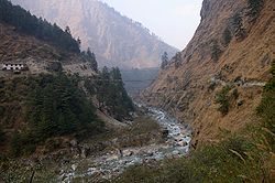
Kali Gandaki Gorge
Encyclopedia
Himalayas
The Himalaya Range or Himalaya Mountains Sanskrit: Devanagari: हिमालय, literally "abode of snow"), usually called the Himalayas or Himalaya for short, is a mountain range in Asia, separating the Indian subcontinent from the Tibetan Plateau...
in Nepal
Nepal
Nepal , officially the Federal Democratic Republic of Nepal, is a landlocked sovereign state located in South Asia. It is located in the Himalayas and bordered to the north by the People's Republic of China, and to the south, east, and west by the Republic of India...
, by some measures the deepest gorge in the world.
The upper part of the gorge is also called Thak Khola after the local Thakali
Thakali
The Thakali are ethnolinguistic group originated from the Thak Khola region of the Mustang District in the Dhaulagiri zone of Nepal. Thakali, like Mutanggi their ancestors, culture and traditions are traced back to ancient himalayan region...
people who became prosperous from trans-Himalayan trade. Geologically it is a downfaulted graben
Graben
In geology, a graben is a depressed block of land bordered by parallel faults. Graben is German for ditch. Graben is used for both the singular and plural....
.
The gorge separates major peaks Dhaulagiri
Dhaulagiri
Dhaulagiri is Earth's seventh highest mountain at ; one of fourteen over eight thousand metres. Dhaulagiri was first climbed May 13, 1960 by a Swiss/Austrian expedition....
(8167 m (26,794.6 ft)) to the west and Annapurna
Annapurna
Annapurna is a section of the Himalayas in north-central Nepal that includes Annapurna I, thirteen additional peaks over and 16 more over ....
(8091 m (26,545.3 ft)) to the east. If one measures the depth of a canyon by the difference between the river height and the heights of the highest peaks on either side, this gorge is the world's deepest. The portion of the river directly between Dhaulagiri and Annapurna I (7 km downstream from Tukuche) is at an elevation of 2520 metres, 5571 metres lower than Annapurna I. The river is older than the Himalayas. As tectonic activity forced the mountains higher, the river cut down through the uplift.This region is famously known for Shaligram(a fossil of sea creature)known as one of five non-living form of Lord Bishnu.
The Kali Gandaki river source is on the coincident Tibet
Tibet
Tibet is a plateau region in Asia, north-east of the Himalayas. It is the traditional homeland of the Tibetan people as well as some other ethnic groups such as Monpas, Qiang, and Lhobas, and is now also inhabited by considerable numbers of Han and Hui people...
border and Ganges
Ganges River
The Ganges or Ganga, , is a trans-boundary river of India and Bangladesh. The river rises in the western Himalayas in the Indian state of Uttarakhand, and flows south and east through the Gangetic Plain of North India into Bangladesh, where it empties into the Bay of Bengal. By discharge it...
-Brahmaputra
Brahmaputra River
The Brahmaputra , also called Tsangpo-Brahmaputra, is a trans-boundary river and one of the major rivers of Asia. It is the only Indian river that is attributed the masculine gender and thus referred to as a in Indo-Aryan languages and languages with Indo-Aryan influence...
watershed divide. The river then flows south through the ancient kingdom of Mustang
Mustang (kingdom)
Mustang is the former Kingdom of Lo and now part of Nepal, in the north-central part of that country, bordering the People's Republic of China on the Tibetan plateau between the Nepalese provinces of Dolpo and Manang...
. It flows through a sheer-sided, deep canyon immediately south of the Mustang kingdom capital of Lo Manthang
Lo Manthang
Lo Manthang is a medieval walled city and Village Development Committee in Mustang District in the Dhawalagiri Zone of northern Nepal. At the time of the 1991 Nepal census it had a population of 876 people living in 178 individual households....
, then widens as it approaches Kagbeni
Kagbeni, Mustang
Kagbeni is a village in Upper Mustang, Nepal, located in the valley of the Kali Gandaki River. Administratively, Kagbeni is a Village Development Committee in Mustang District in the Dhawalagiri Zone of northern Nepal. At the time of the 1991 Nepal census it had a population of 1200 people...
where high Himalayan ranges begin to close in. The river continues southwards past Jomsom
Jomsom
Jomsom , also known as Dzongsam or New Fort, is a town located at an altitude of 2800m in Mustang, Nepal. It extends over both the banks of the Kali Gandaki River. Along the banks of Kali Gandaki river there are rocks holy to the Hindus. The soaring peaks of Dhaulagiri and Nilgiri form a backdrop...
, Marpha
Marpha
Marpha is a village development committee in Mustang District in the Dhawalagiri Zone of northern Nepal. At the time of the 1991 Nepal census it had a population of 1630 people living in 434 individual households....
and Tukuche
Tukuche
Tukuche , sometimes spelt Tukche, is a village development committee in Mustang District in the Dhawalagiri Zone of northern Nepal. At the time of the 1991 Nepal census it had a population of 652 people living in 166 individual households....
to the deepest part of the gorge about 7 km south of Tukuche in the area of Lete
Lete, Nepal
Lete is a village development committee in Mustang District in the Dhawalagiri Zone of northern Nepal. At the time of the 1991 Nepal census it had a population of 914 people living in 189 individual households.It is a scenic village surrounded by Dhawalagiri, Annapurna and Nilgiri. This village is...
. The gorge then broadens past Dana
Dana, Nepal
Dana, Nepal is a village development committee in Myagdi District in the Dhawalagiri Zone of western-central Nepal. At the time of the 1991 Nepal census it had a population of 1787 people living in 398 individual households.-External links:*...
and Tatopani
Tatopani, Myagdi
Tatopani is a village development committee in Myagdi District in the Dhawalagiri Zone of western-central Nepal. At the time of the 1991 Nepal census it had a population of 843 people living in 182 individual households.-External links:*...
towards Beni.
The Kali Gandaki gorge has been used as a trade route between India and Tibet for centuries. Today, it is part of a popular trekking
Hiking
Hiking is an outdoor activity which consists of walking in natural environments, often in mountainous or other scenic terrain. People often hike on hiking trails. It is such a popular activity that there are numerous hiking organizations worldwide. The health benefits of different types of hiking...
route from Pokhara
Pokhara
Pokhara Sub-Metropolitan City is the second largest city of Nepal. Pokhara is city of close to 350,000 inhabitants in central Nepal located at 28.25°N, 83.99°E, which is the centre of the country from east to west or from north to south, 198 km west of Kathmandu or 90 km west of Mugling, and...
to Muktinath
Muktinath
Muktinath is a sacred place both for Hindus and Buddhists located in Muktinath Valley at an altitude of 3,710 meters at the foot of the Thorong La mountain pass , Mustang district, Nepal...
, part of the Annapurna Circuit. The gorge is within the Annapurna Conservation Area.