

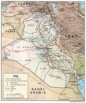
Geography of Iraq
Encyclopedia
Iraq
Iraq ; officially the Republic of Iraq is a country in Western Asia spanning most of the northwestern end of the Zagros mountain range, the eastern part of the Syrian Desert and the northern part of the Arabian Desert....
is diverse and falls into four main regions: the desert (west of the Euphrates
Euphrates
The Euphrates is the longest and one of the most historically important rivers of Western Asia. Together with the Tigris, it is one of the two defining rivers of Mesopotamia...
), Upper Mesopotamia (between the upper Tigris
Tigris
The Tigris River is the eastern member of the two great rivers that define Mesopotamia, the other being the Euphrates. The river flows south from the mountains of southeastern Turkey through Iraq.-Geography:...
and Euphratesh rivers), the northern highlands of Iraqi Kurdistan
Iraqi Kurdistan
Iraqi Kurdistan or Kurdistan Region is an autonomous region of Iraq. It borders Iran to the east, Turkey to the north, Syria to the west and the rest of Iraq to the south. The regional capital is Arbil, known in Kurdish as Hewlêr...
, and Lower Mesopotamia, the alluvial plain extending from around Tikrit
Tikrit
Tikrit is a town in Iraq, located 140 km northwest of Baghdad on the Tigris river . The town, with an estimated population in 2002 of about 260,000 is the administrative center of the Salah ad Din Governorate.-Ancient times:...
to the Persian Gulf
Persian Gulf
The Persian Gulf, in Southwest Asia, is an extension of the Indian Ocean located between Iran and the Arabian Peninsula.The Persian Gulf was the focus of the 1980–1988 Iran-Iraq War, in which each side attacked the other's oil tankers...
.
The mountains in the northeast are an extension of the alpine system that runs eastward from the Balkans
Balkans
The Balkans is a geopolitical and cultural region of southeastern Europe...
through southern Turkey
Turkey
Turkey , known officially as the Republic of Turkey , is a Eurasian country located in Western Asia and in East Thrace in Southeastern Europe...
, northern Iraq
Iraq
Iraq ; officially the Republic of Iraq is a country in Western Asia spanning most of the northwestern end of the Zagros mountain range, the eastern part of the Syrian Desert and the northern part of the Arabian Desert....
, Iran
Iran
Iran , officially the Islamic Republic of Iran , is a country in Southern and Western Asia. The name "Iran" has been in use natively since the Sassanian era and came into use internationally in 1935, before which the country was known to the Western world as Persia...
, and Afghanistan
Afghanistan
Afghanistan , officially the Islamic Republic of Afghanistan, is a landlocked country located in the centre of Asia, forming South Asia, Central Asia and the Middle East. With a population of about 29 million, it has an area of , making it the 42nd most populous and 41st largest nation in the world...
, eventually reaching the Himalayas
Himalayas
The Himalaya Range or Himalaya Mountains Sanskrit: Devanagari: हिमालय, literally "abode of snow"), usually called the Himalayas or Himalaya for short, is a mountain range in Asia, separating the Indian subcontinent from the Tibetan Plateau...
. The desert
Desert
A desert is a landscape or region that receives an extremely low amount of precipitation, less than enough to support growth of most plants. Most deserts have an average annual precipitation of less than...
is in the southwest and central provinces along the borders with Saudi Arabia
Saudi Arabia
The Kingdom of Saudi Arabia , commonly known in British English as Saudi Arabia and in Arabic as as-Sa‘ūdiyyah , is the largest state in Western Asia by land area, constituting the bulk of the Arabian Peninsula, and the second-largest in the Arab World...
and Jordan
Jordan
Jordan , officially the Hashemite Kingdom of Jordan , Al-Mamlaka al-Urduniyya al-Hashemiyya) is a kingdom on the East Bank of the River Jordan. The country borders Saudi Arabia to the east and south-east, Iraq to the north-east, Syria to the north and the West Bank and Israel to the west, sharing...
and geographically belongs with the Arabian Peninsula
Arabian Peninsula
The Arabian Peninsula is a land mass situated north-east of Africa. Also known as Arabia or the Arabian subcontinent, it is the world's largest peninsula and covers 3,237,500 km2...
.
Iraq holds a special distinction in the history of geography
Geography
Geography is the science that studies the lands, features, inhabitants, and phenomena of Earth. A literal translation would be "to describe or write about the Earth". The first person to use the word "geography" was Eratosthenes...
: a clay tablet
Clay tablet
In the Ancient Near East, clay tablets were used as a writing medium, especially for writing in cuneiform, throughout the Bronze Age and well into the Iron Age....
generally accepted as "the earliest known map" was unearthed in 1930 during the excavation of Ga-Sur at Nuzi Yorghan Tepe, near the towns of Harran
Harran
Harran was a major ancient city in Upper Mesopotamia whose site is near the modern village of Altınbaşak, Turkey, 24 miles southeast of Şanlıurfa...
and Kirkuk
Kirkuk
Kirkuk is a city in Iraq and the capital of Kirkuk Governorate.It is located in the Iraqi governorate of Kirkuk, north of the capital, Baghdad...
, 200 miles (322 km) north of the site of Babylon
Babylon
Babylon was an Akkadian city-state of ancient Mesopotamia, the remains of which are found in present-day Al Hillah, Babil Province, Iraq, about 85 kilometers south of Baghdad...
. The tablet, measuring 6.8 by 7.6 in (172.7 by 193 mm), is usually dated from the dynasty of Sargon of Akkad
Sargon of Akkad
Sargon of Akkad, also known as Sargon the Great "the Great King" , was an Akkadian emperor famous for his conquest of the Sumerian city-states in the 23rd and 22nd centuries BC. The founder of the Dynasty of Akkad, Sargon reigned in the last quarter of the third millennium BC...
between 2500-2300 BC; an even earlier date for the tablet was promulgated by archeologist Leo Bagrow
Leo Bagrow
Leo Bagrow , born Lev Semenovich Bagrow, was a historian of cartography and the founder of the journal Imago Mundi.-External Links:* at , Harvard University...
, placing it in the Agade Period (3800 BC).
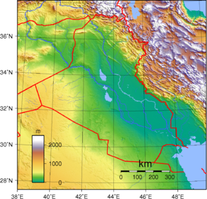
Major geographical features
Most geographers, including those of the Iraqi government, discuss the country's geography in terms of four main zones or regions: the desertDesert
A desert is a landscape or region that receives an extremely low amount of precipitation, less than enough to support growth of most plants. Most deserts have an average annual precipitation of less than...
in the west and southwest; the rolling upland between the upper Tigris and Euphrates rivers (in Arabic the Dijlis and Furat, respectively); the highlands in the north and northeast; and the alluvial plain through which the Tigris and Euphrates flow.
Iraq's official statistical reports give the total land area as 438446 km² (169,284.9 sq mi), whereas a United States Department of State
United States Department of State
The United States Department of State , is the United States federal executive department responsible for international relations of the United States, equivalent to the foreign ministries of other countries...
publication gives the area as 434934 km² (167,929 sq mi).
Upper Mesopotamia
The uplands region, between the Tigris north of SamarraSamarra
Sāmarrā is a city in Iraq. It stands on the east bank of the Tigris in the Salah ad-Din Governorate, north of Baghdad and, in 2003, had an estimated population of 348,700....
and the Euphrates north of Hit, is known as Al Jazira
Al-Jazira, Mesopotamia
Upper Mesopotamia is the name used for the uplands and great outwash plain of northwestern Iraq and northeastern Syria and southeastern Turkey which is known by the traditional Arabic name of Al-Jazira , variously transliterated into Roman script as Djazirah, Djezirah and Jazirah...
(the island) and is part of a larger area that extends westward into Syria between the two rivers and into Turkey
Turkey
Turkey , known officially as the Republic of Turkey , is a Eurasian country located in Western Asia and in East Thrace in Southeastern Europe...
. Water in the area flows in deeply cut valleys, and irrigation
Irrigation
Irrigation may be defined as the science of artificial application of water to the land or soil. It is used to assist in the growing of agricultural crops, maintenance of landscapes, and revegetation of disturbed soils in dry areas and during periods of inadequate rainfall...
is much more difficult than it is in the lower plain. Much of this zone may be classified as desert.
Lower Mesopotamia
An Alluvial plainAlluvial plain
An alluvial plain is a relatively flat landform created by the deposition of sediment over a long period of time by one or more rivers coming from highland regions, from which alluvial soil forms...
begins north of Baghdad
Baghdad
Baghdad is the capital of Iraq, as well as the coterminous Baghdad Governorate. The population of Baghdad in 2011 is approximately 7,216,040...
and extends to the Persian Gulf
Persian Gulf
The Persian Gulf, in Southwest Asia, is an extension of the Indian Ocean located between Iran and the Arabian Peninsula.The Persian Gulf was the focus of the 1980–1988 Iran-Iraq War, in which each side attacked the other's oil tankers...
. Here the Tigris and Euphrates rivers lie above the level of the plain in many places, and the whole area is a river delta
River delta
A delta is a landform that is formed at the mouth of a river where that river flows into an ocean, sea, estuary, lake, reservoir, flat arid area, or another river. Deltas are formed from the deposition of the sediment carried by the river as the flow leaves the mouth of the river...
interlaced by the channels of the two rivers and by irrigation canals. Intermittent lake
Lake
A lake is a body of relatively still fresh or salt water of considerable size, localized in a basin, that is surrounded by land. Lakes are inland and not part of the ocean and therefore are distinct from lagoons, and are larger and deeper than ponds. Lakes can be contrasted with rivers or streams,...
s, fed by the rivers in flood, also characterize southeastern Iraq. A fairly large area (15000 square kilometre) just above the confluence of the two rivers at Al Qurnah and extending east of the Tigris beyond the Iranian border is marshland, known as Hawr al Hammar, the result of centuries of flooding and inadequate drainage. Much of it is permanent marsh, but some parts dry out in early winter, and other parts become marshland only in years of great flood.
Because the waters of the Tigris and Euphrates above their confluence are heavily silt
Silt
Silt is granular material of a size somewhere between sand and clay whose mineral origin is quartz and feldspar. Silt may occur as a soil or as suspended sediment in a surface water body...
- laden, irrigation
Irrigation
Irrigation may be defined as the science of artificial application of water to the land or soil. It is used to assist in the growing of agricultural crops, maintenance of landscapes, and revegetation of disturbed soils in dry areas and during periods of inadequate rainfall...
and fairly frequent flooding deposit large quantities of silty loam in much of the delta area. Windborne silt contributes to the total deposit of sediments. It has been estimated that the delta plains are built up at the rate of nearly twenty centimeters in a century. In some areas, major floods lead to the deposit in temporary lakes of as much as thirty centimeters of mud.
The Tigris and Euphrates also carry large quantities of salt
Salt
In chemistry, salts are ionic compounds that result from the neutralization reaction of an acid and a base. They are composed of cations and anions so that the product is electrically neutral...
s. These, too, are spread on the land by sometimes excessive irrigation and flooding. A high water table
Water table
The water table is the level at which the submarine pressure is far from atmospheric pressure. It may be conveniently visualized as the 'surface' of the subsurface materials that are saturated with groundwater in a given vicinity. However, saturated conditions may extend above the water table as...
and poor surface and subsurface drainage tend to concentrate the salts near the surface of the soil. In general, the salinity of the soil increases from Baghdad south to the Persian Gulf and severely limits productivity in the region south of Al Amarah. The salinity
Salinity
Salinity is the saltiness or dissolved salt content of a body of water. It is a general term used to describe the levels of different salts such as sodium chloride, magnesium and calcium sulfates, and bicarbonates...
is reflected in the large lake in central Iraq, southwest of Baghdad, known as Bahr al Milh (Sea of Salt). There are two other major lakes in the country to the north of Bahr al Milh: Buhayrat ath Tharthar and Buhayrat al Habbaniyah.
Baghdad area
Between Upper and Lower Mesopotamia is the urban area surrounding BaghdadBaghdad
Baghdad is the capital of Iraq, as well as the coterminous Baghdad Governorate. The population of Baghdad in 2011 is approximately 7,216,040...
.
These "Baghdad Belts
Baghdad Belts
The Baghdad Belts are the residential, agricultural and industrial areas, as well as communications and transportation infrastructure that encircle the Iraqi capital and connect it to other areas in Iraq...
" can be described as the provinces adjacent to the Iraqi capital and can be divided into four quadrants: Northeast, Southeast, Southwest, and Northwest. Beginning in the north, the belts include the province of Salah ad Din, clockwise to Baghdad province, Diyala in the North-east, Babil and Wasit in the south east and around to Al Anbar in the west.
Highlands
The northeastern highlands begin just south of a line drawn from MosulMosul
Mosul , is a city in northern Iraq and the capital of the Ninawa Governorate, some northwest of Baghdad. The original city stands on the west bank of the Tigris River, opposite the ancient Assyrian city of Nineveh on the east bank, but the metropolitan area has now grown to encompass substantial...
to Kirkuk
Kirkuk
Kirkuk is a city in Iraq and the capital of Kirkuk Governorate.It is located in the Iraqi governorate of Kirkuk, north of the capital, Baghdad...
and extend to the borders with Turkey
Turkey
Turkey , known officially as the Republic of Turkey , is a Eurasian country located in Western Asia and in East Thrace in Southeastern Europe...
and Iran
Iran
Iran , officially the Islamic Republic of Iran , is a country in Southern and Western Asia. The name "Iran" has been in use natively since the Sassanian era and came into use internationally in 1935, before which the country was known to the Western world as Persia...
. High ground, separated by broad, undulating steppe
Steppe
In physical geography, steppe is an ecoregion, in the montane grasslands and shrublands and temperate grasslands, savannas, and shrublands biomes, characterized by grassland plains without trees apart from those near rivers and lakes...
s, gives way to mountains ranging from 1000 to 4000 m (3,280.8 to 13,123.4 ft) near the Iranian and Turkish borders. Except for a few valleys, the mountain area proper is suitable only for grazing in the foothills and steppes; adequate soil and rainfall, however, make cultivation possible. Here, too, are the great oil fields near Mosul and Kirkuk. The northeast is the homeland of most Iraqi Kurd
Kürd
Kürd or Kyurd or Kyurt may refer to:*Kürd Eldarbəyli, Azerbaijan*Kürd Mahrızlı, Azerbaijan*Kürd, Goychay, Azerbaijan*Kürd, Jalilabad, Azerbaijan*Kürd, Qabala, Azerbaijan*Qurdbayram, Azerbaijan...
s.
Desert
The desert zone, an area lying west and southwest of the Euphrates River, is a part of the Syrian DesertSyrian Desert
The Syrian Desert , also known as the Syro-Arabian desert is a combination of steppe and true desert that is located in the northern Arabian Peninsula covering 200,000 square miles . also the desert is very rocky and flat...
, which covers sections of Syria
Syria
Syria , officially the Syrian Arab Republic , is a country in Western Asia, bordering Lebanon and the Mediterranean Sea to the West, Turkey to the north, Iraq to the east, Jordan to the south, and Israel to the southwest....
, Jordan
Jordan
Jordan , officially the Hashemite Kingdom of Jordan , Al-Mamlaka al-Urduniyya al-Hashemiyya) is a kingdom on the East Bank of the River Jordan. The country borders Saudi Arabia to the east and south-east, Iraq to the north-east, Syria to the north and the West Bank and Israel to the west, sharing...
, and Saudi Arabia
Saudi Arabia
The Kingdom of Saudi Arabia , commonly known in British English as Saudi Arabia and in Arabic as as-Sa‘ūdiyyah , is the largest state in Western Asia by land area, constituting the bulk of the Arabian Peninsula, and the second-largest in the Arab World...
. The region, sparsely inhabited by pastoral nomads, consists of a wide, stony plain interspersed with rare sandy stretches. A widely ramified pattern of wadi
Wadi
Wadi is the Arabic term traditionally referring to a valley. In some cases, it may refer to a dry riverbed that contains water only during times of heavy rain or simply an intermittent stream.-Variant names:...
s–watercourses that are dry most of the year–runs from the border to the Euphrates. Some wadi
Wadi
Wadi is the Arabic term traditionally referring to a valley. In some cases, it may refer to a dry riverbed that contains water only during times of heavy rain or simply an intermittent stream.-Variant names:...
s are over 400 km (248.5 mi) long and carry brief but torrential floods during the winter rains.
Tigris-Euphrates river system
The Euphrates originates in Turkey, is augmented by the Balikh and KhaburKhabur River
The Khabur River , , , ) is the largest perennial tributary to the Euphrates in Syrian territory. Although the Khabur originates in Turkey, the karstic springs around Ra's al-'Ayn are the river's main source of water. Several important wadis join the Khabur north of Al-Hasakah, together creating...
rivers in Syria, and enters Iraq in the northwest. Here it is fed only by the wadis of the western desert during the winter rains. It then winds through a gorge, which varies from two to 16 kilometers in width, until it flows out on the plain at Ar Ramadi. Beyond there the Euphrates continues to the Hindiya Barrage
Hindiya Barrage
The Hindiya Barrage is located on the Euphrates south of the town of Musayyib in Babil Governorate, Iraq. It was designed by British civil engineer William Willcocks in response to the silting up of the Hillah branch of the Euphrates. Construction of the dam, with a length of over , lasted between...
, which was constructed in 1914 to divert the river into the Hindiyah Channel; the present day Shatt al Hillah had been the main channel of the Euphrates before 1914. Below Al Kifl
Al Kifl
Al Kifl is a town in southeastern Iraq on the Euphrates River, between Najaf and Al Hillah. The population in and near the town is about 15,000. Kifl is the location of a tomb claimed to be that of holy man Dhul-Kifl who is believed be the biblical prophet Ezekiel...
, the river follows two channels to As-Samawah, where it reappears as a single channel to join the Tigris at Al Qurnah.
The Tigris also rises in Turkey but is significantly augmented by several rivers in Iraq, the most important of which are the Khabur
Khabur (Tigris)
The Khabur is a river that begins in the Uludere district of the Şırnak Province, in the Eastern Anatolia Region in Turkey, it consists of a combination of small rivers that flow off the Bolkar mountain range south-east of Hakkâri...
, the Great Zab
Great Zab
The Great Zab , , , ) is an approximately long river flowing through Turkey and Iraq. It rises in Turkey near Lake Van and joins the Tigris in Iraq south of Mosul. The drainage basin of the Great Zab covers approximately , and during its course, the rivers collects the water from a large number...
, the Little Zab
Little Zab
The Little Zab , , ) originates in Iran and joins the Tigris in Iraq. The river is approximately long and drains an area of c. . The river is fed by rainfall and snowmelt, resulting in a peak discharge in spring and low water in summer and early fall...
, and the Adhaim, all of which join the Tigris above Baghdad, and the Diyala
Diyala River
The Diyala River after Darban-e Khan Dam:Kurdish: Sirwan, سيروان, , Persian: سیروان دیاله, is a river and tributary of the Tigris that runs mainly through Eastern Iraq but also Western Iran. It covers a total distance of ....
, which joins it about thirty-six kilometers below the city. At the Kut Barrage
Kut Barrage
The Kut Barrage is a barrage on the Tigris river, located in the modern town of Kut in Wasit Governorate, Iraq. It is long, high and consists of 56 gates, each wide. The maximum discharge of the barrage is , but actual discharge has not exceeded in the last 10 years. The barrage supports a road...
much of the water is diverted into the Shatt al-Hayy
Shatt al-Hayy
The Gharraf Canal, Shaṭṭ al-Ḥayy , also known as Shaṭṭ al-Gharrāf or the Hai river, is an ancient canal that connects Tigris with Euphrates in Iraq. As an Ottoman defensive line lay along the canal, it was a theater to intense military action during First World War; e.g. the siege of Kut...
, which was once the main channel of the Tigris. Water from the Tigris thus enters the Euphrates through the Shatt al-Hayy well above the confluence of the two main channels at Al Qurnah.
Both the Tigris and the Euphrates break into a number of channels in the marshland area, and the flow of the rivers is substantially reduced by the time they come together at Al Qurnah. Moreover. the swamps act as silt traps, and the Shatt al Arab is relatively silt free as it flows south. Below Basra
Basra
Basra is the capital of Basra Governorate, in southern Iraq near Kuwait and Iran. It had an estimated population of two million as of 2009...
, however, the Karun River enters the Shatt al Arab from Iran, carrying large quantities of silt that present a continuous dredging problem in maintaining a channel for ocean-going vessels to reach the port at Basra
Basra
Basra is the capital of Basra Governorate, in southern Iraq near Kuwait and Iran. It had an estimated population of two million as of 2009...
. This problem has been superseded by a greater obstacle to river traffic, however, namely the presence of several sunken hulls that have been rusting in the Shatt al Arab since early in the Iran-Iraq war.
The waters of the Tigris and Euphrates are essential to the life of the country, but they sometimes threaten it. The rivers are at their lowest level in September and October and at flood in March, April, and May when they may carry forty times as much water as at low mark. Moreover, one season's flood may be ten or more times as great as that in another year. In 1954, for example, Baghdad was seriously threatened, and dikes protecting it were nearly topped by the flooding Tigris. Since Syria built a dam on the Euphrates, the flow of water has been considerably diminished and flooding was no longer a problem in the mid-1980s. In 1988 Turkey was also constructing a dam on the Euphrates that would further restrict the water flow.
Until the mid-twentieth century, most efforts to control the waters were primarily concerned with irrigation. Some attention was given to problems of flood control and drainage before the revolution of July 14, 1958, but development plans in the 1960s and 1970s were increasingly devoted to these matters, as well as to irrigation projects on the upper reaches of the Tigris and Euphrates and the tributaries of the Tigris in the northeast. During the war, government officials stressed to foreign visitors that, with the conclusion of a peace settlement, problems of irrigation and flooding would receive top priority from the government.
Settlement patterns
In the rural areas of the alluvial plain and in the lower Diyala region, settlement almost invariably clusters near the rivers, streams, and irrigation canals. The bases of the relationship between watercourse and settlement have been summarized by Robert McCormick Adams, director of the Oriental Institute of the University of ChicagoUniversity of Chicago
The University of Chicago is a private research university in Chicago, Illinois, USA. It was founded by the American Baptist Education Society with a donation from oil magnate and philanthropist John D. Rockefeller and incorporated in 1890...
. He notes that the levees laid down by streams and canals provide advantages for both settlement and agriculture. Surface water drains more easily on the levees' backslope, and the coarse soils of the levees are easier to cultivate and permit better subsurface drainage. The height of the levees gives some protection against floods and the frost that often affect low-lying areas and may kill winter crops. Above all, those living or cultivating on the crest of a levee have easy access to water for irrigation and household use in a dry, hot country.
Although there are some isolated homesteads, most rural communities are nucleated settlements rather than dispersed farmsteads; that is, the farmer leaves his village to cultivate the fields outside it. The pattern holds for farming communities in the Kurd
Kürd
Kürd or Kyurd or Kyurt may refer to:*Kürd Eldarbəyli, Azerbaijan*Kürd Mahrızlı, Azerbaijan*Kürd, Goychay, Azerbaijan*Kürd, Jalilabad, Azerbaijan*Kürd, Qabala, Azerbaijan*Qurdbayram, Azerbaijan...
ish highlands of the northeast as well as for those in the alluvial plain. The size of the settlement varies, generally with the volume of water available for household use and with the amount of land accessible to village dwellers. Sometimes, particularly in the lower Tigris and Euphrates valleys, soil salinity restricts the area of arable land and limits the size of the community dependent on it, and it also usually results in large unsettled and uncultivated stretches between the villages.
Fragmentary information suggests that most farmers in the alluvial plain tend to live in villages of over 100 persons. For example, in the mid-1970s a substantial number of the residents of Baqubah
Baqubah
Baqubah is the capital of Iraq's Diyala Governorate.The city is located some to the northeast of Baghdad, on the Diyala River. In 2003 it had an estimated population of some 467,900 people....
, the administrative center and major city of Diyala Governorate, were employed in agriculture.
The Marsh Arabs (the Madan) of the south usually live in small clusters of two or three houses kept above water by rushes
Juncaceae
Juncaceae, the rush family, are a monocotyledonous family of flowering plants. There are eight genera and about 400 species. Members of the Juncaceae are slow-growing, rhizomatous, herbaceous plants, and they may superficially resemble grasses. They often grow on infertile soils in a wide range...
that are constantly being replenished. Such clusters often are close together, but access from one to another is possible only by small boat. Here and there a few natural islands permit slightly larger clusters. Some of these people are primarily water buffalo herders and lead a semi-nomadic life. In the winter, when the waters are at a low point, they build fairly large temporary villages. In the summer they move their herds out of the marshes to the river banks.
The war has had its effect on the lives of these denizens of the marshes. With much of the fighting concentrated in their areas, they have either migrated to settled communities away from the marshes or have been forced by government decree to relocate within the marshes. Also, in early 1988, the marshes had become the refuge of deserters from the Iraqi army who attempted to maintain life in the fastness of the overgrown, desolate areas while hiding out from the authorities. These deserters in many instances have formed into large gangs that raid the marsh communities; this also has induced many of the marsh dwellers to abandon their villages.
The war has also affected settlement patterns in the northern Kurd
Kürd
Kürd or Kyurd or Kyurt may refer to:*Kürd Eldarbəyli, Azerbaijan*Kürd Mahrızlı, Azerbaijan*Kürd, Goychay, Azerbaijan*Kürd, Jalilabad, Azerbaijan*Kürd, Qabala, Azerbaijan*Qurdbayram, Azerbaijan...
ish areas. There, the persistence of a stubborn rebellion by Kurdish guerrillas has goaded the government into applying steadily escalating violence against the local communities. Starting in 1984, the government launched a scorched-earth campaign to drive a wedge between the villagers and the guerrillas in the remote areas of two provinces of Kurdistan in which Kurdish guerrillas were active. In the process whole villages were torched and subsequently bulldozed, which resulted in the Kurds flocking into the regional centers of Irbil and As Sulaymaniyah. Also as a military precaution, the government has cleared a broad strip of territory in the Kurdish region along the Iran
Iran
Iran , officially the Islamic Republic of Iran , is a country in Southern and Western Asia. The name "Iran" has been in use natively since the Sassanian era and came into use internationally in 1935, before which the country was known to the Western world as Persia...
ian border of all its inhabitants, hoping in this way to interdict the movement of Kurdish guerrillas back and forth between Iran and Iraq. The majority of Kurd
Kürd
Kürd or Kyurd or Kyurt may refer to:*Kürd Eldarbəyli, Azerbaijan*Kürd Mahrızlı, Azerbaijan*Kürd, Goychay, Azerbaijan*Kürd, Jalilabad, Azerbaijan*Kürd, Qabala, Azerbaijan*Qurdbayram, Azerbaijan...
ish villages, however, remained intact in early 1988.
In the arid areas of Iraq to the west and south, cities and large towns are almost invariably situated on watercourses, usually on the major rivers or their larger tributaries. In the south this dependence has had its disadvantages. Until the recent development of flood control, Baghdad
Baghdad
Baghdad is the capital of Iraq, as well as the coterminous Baghdad Governorate. The population of Baghdad in 2011 is approximately 7,216,040...
and other cities were subject to the threat of inundation. Moreover, the dikes needed for protection have effectively prevented the expansion of the urban areas in some directions. The growth of Baghdad
Baghdad
Baghdad is the capital of Iraq, as well as the coterminous Baghdad Governorate. The population of Baghdad in 2011 is approximately 7,216,040...
, for example, was restricted by dikes on its eastern edge. The diversion of water to the Milhat ath Tharthar and the construction of a canal transferring water from the Tigris north of Baghdad to the Diyala River
Diyala River
The Diyala River after Darban-e Khan Dam:Kurdish: Sirwan, سيروان, , Persian: سیروان دیاله, is a river and tributary of the Tigris that runs mainly through Eastern Iraq but also Western Iran. It covers a total distance of ....
have permitted the irrigation of land outside the limits of the dikes and the expansion of settlement.
Climate
Average temperatures in Iraq range from higher than 48 °C (118.4 °F) in July and August to below freezing in January. Most of the rainfall occurs from December through April and averages between 100 and 180 mm (3.9 and 7.1 ) annually. The mountainous region of northern Iraq receives appreciably more precipitation than the central or southern desert region.Roughly 90% of the annual rainfall occurs between November and April, most of it in the winter months from December through March. The remaining six months, particularly the hottest ones of June, July, and August, are dry.
Except in the north and northeast, mean annual rainfall ranges between 100 and 170 mm (3.9 and 6.7 in). Data available from stations in the foothills and steppes south and southwest of the mountains suggest mean annual rainfall between 320 and 570 mm (12.6 and 22.4 in) for that area. Rainfall in the mountains is more abundant and may reach 1000 millimetres (39.4 in) a year in some places, but the terrain precludes extensive cultivation. Cultivation on nonirrigated land is limited essentially to the mountain valleys, foothills, and steppes, which have 300 millimetres (11.8 in) or more of rainfall annually. Even in this zone, however, only one crop a year can be grown, and shortages of rain have often led to crop failures.
Mean minimum temperatures in the winter range from near freezing (just before dawn) in the northern and northeastern foothills and the western desert to 2 to 3 °C (35.6 to 37.4 F) and 4 to 5 °C (39.2 to 41 F) in the alluvial plains of southern Iraq. They rise to a mean maximum of about 16 °C (60.8 °F) in the western desert and the northeast, and 17 °C (62.6 °F) in the south. In the summer mean minimum temperatures range from about 27 to 34 °C (80.6 to 93.2 F) and rise to maximums between roughly 42 and 47 °C (107.6 and 116.6 F). Temperatures sometimes fall below freezing and have fallen as low as -14 °C at Ar Rutbah in the western desert. They are more likely, however, to go over 49 °C (120.2 °F) in the summer months, and several stations have records of over 53 °C (127.4 °F).
The summer months are marked by two kinds of wind phenomena. The southern and southeasterly sharqi, a dry, dusty wind with occasional gusts of 80 kilometres per hour (49.7 mph), occurs from April to early June and again from late September through November. It may last for a day at the beginning and end of the season but for several days at other times. This wind is often accompanied by violent duststorms that may rise to heights of several thousand meters and close airports for brief periods. From mid-June to mid-September the prevailing wind, called the shamal, is from the north and northwest. It is a steady wind, absent only occasionally during this period. The very dry air brought by this shamal permits intensive sun heating of the land surface, but the breeze has some cooling effect.
The combination of rain shortage and extreme heat makes much of Iraq a desert. Because of very high rates of evaporation, soil and plants rapidly lose the little moisture obtained from the rain, and vegetation could not survive without extensive irrigation. Some areas, however, although arid, do have natural vegetation in contrast to the desert. For example, in the Zagros Mountains in northeastern Iraq there is permanent vegetation, such as oak
Oak
An oak is a tree or shrub in the genus Quercus , of which about 600 species exist. "Oak" may also appear in the names of species in related genera, notably Lithocarpus...
trees, and date palm
Date Palm
The date palm is a palm in the genus Phoenix, cultivated for its edible sweet fruit. Although its place of origin is unknown because of long cultivation, it probably originated from lands around the Persian Gulf. It is a medium-sized plant, 15–25 m tall, growing singly or forming a clump with...
s are found in the south.
Area and boundaries
In 1922 British officials concluded the Treaty of Mohammara with Abd al Aziz ibn Abd ar Rahman Al Saud, who in 1932 formed the Kingdom of Saudi Arabia. The treaty provided the basic agreement for the boundary between the eventually independent nations. Also in 1922 the two parties agreed to the creation of the diamond-shaped Neutral Zone of approximately 7500 km² (2,895.8 sq mi) adjacent to the western tip of Kuwait in which neither Iraq nor Saudi Arabia would build dwellings or installations. BedouinBedouin
The Bedouin are a part of a predominantly desert-dwelling Arab ethnic group traditionally divided into tribes or clans, known in Arabic as ..-Etymology:...
s from either country could utilize the limited water and seasonal grazing resources of the zone. In April 1975, an agreement signed in Baghdad
Baghdad
Baghdad is the capital of Iraq, as well as the coterminous Baghdad Governorate. The population of Baghdad in 2011 is approximately 7,216,040...
fixed the borders of the countries.
Through Algeria
Algeria
Algeria , officially the People's Democratic Republic of Algeria , also formally referred to as the Democratic and Popular Republic of Algeria, is a country in the Maghreb region of Northwest Africa with Algiers as its capital.In terms of land area, it is the largest country in Africa and the Arab...
n mediation, Iran and Iraq agreed in March 1975 to normalize their relations, and three months later they signed a treaty known as the Algiers Accord. The document defined the common border all along the Khawr Abd Allah
Khawr Abd Allah
The Khawr Abd Allah is today an estuary, but once was the point where the great Euphrates and Tigris rivers emptied into the Persian Gulf. Located in the south of Iraq, the Iraq-Kuwaiti border divides the lower portion of the estuary, but adjacent to the port of Umm Qasr the estuary becomes wholly...
(Shatt) River estuary
Estuary
An estuary is a partly enclosed coastal body of water with one or more rivers or streams flowing into it, and with a free connection to the open sea....
as the thalweg
Thalweg
Thalweg in geography and fluvial geomorphology signifies the deepest continuous inline within a valley or watercourse system.-Hydrology:In hydrological and fluvial landforms, the thalweg is a line drawn to join the lowest points along the entire length of a stream bed or valley in its downward...
. To compensate Iraq for the loss of what formerly had been regarded as its territory, pockets of territory along the mountain border in the central sector of its common boundary with Iran were assigned to it. Nonetheless, in September 1980 Iraq went to war with Iran
Iran
Iran , officially the Islamic Republic of Iran , is a country in Southern and Western Asia. The name "Iran" has been in use natively since the Sassanian era and came into use internationally in 1935, before which the country was known to the Western world as Persia...
, citing among other complaints the fact that Iran had not turned over to it the land specified in the Algiers Accord. This problem has subsequently proved to be a stumbling block to a negotiated settlement of the ongoing conflict.
In 1988 the boundary with Kuwait
Kuwait
The State of Kuwait is a sovereign Arab state situated in the north-east of the Arabian Peninsula in Western Asia. It is bordered by Saudi Arabia to the south at Khafji, and Iraq to the north at Basra. It lies on the north-western shore of the Persian Gulf. The name Kuwait is derived from the...
was another outstanding problem. It was fixed in a 1913 treaty between the Ottoman Empire
Ottoman Empire
The Ottoman EmpireIt was usually referred to as the "Ottoman Empire", the "Turkish Empire", the "Ottoman Caliphate" or more commonly "Turkey" by its contemporaries...
and British
United Kingdom
The United Kingdom of Great Britain and Northern IrelandIn the United Kingdom and Dependencies, other languages have been officially recognised as legitimate autochthonous languages under the European Charter for Regional or Minority Languages...
officials acting on behalf of Kuwait's ruling family
Politics of Kuwait
The government of Kuwait consists of a parliamentary constitutional monarchy, whereby the Emir is the head of government. The State of Kuwait has been ruled by the al-Sabah dynasty since approximately 1752. The constitution, approved and promulgated on November 11, 1962, calls for direct elections...
, which in 1899 had ceded control over foreign affairs to Britain. The boundary was accepted by Iraq when it became independent in 1932, but in the 1960s and again in the mid-1970s, the Iraqi government advanced a claim to parts of Kuwait. Kuwait
Kuwait
The State of Kuwait is a sovereign Arab state situated in the north-east of the Arabian Peninsula in Western Asia. It is bordered by Saudi Arabia to the south at Khafji, and Iraq to the north at Basra. It lies on the north-western shore of the Persian Gulf. The name Kuwait is derived from the...
made several representations to the Iraqis during the war to fix the border once and for all but Baghdad
Baghdad
Baghdad is the capital of Iraq, as well as the coterminous Baghdad Governorate. The population of Baghdad in 2011 is approximately 7,216,040...
repeatedly demurred, claiming that the issue is a potentially divisive one that could inflame nationalist sentiment inside Iraq. Hence in 1988 it was likely that a solution would have to wait until the war ended.
Area:
total: 437072 km² (168,754.4 sq mi)
land: 432162 km² (166,858.7 sq mi)
water: 4910 km² (1,895.8 sq mi)
Land boundaries:
total: 3631 km (2,256.2 mi)
border countries: Iran
Iran
Iran , officially the Islamic Republic of Iran , is a country in Southern and Western Asia. The name "Iran" has been in use natively since the Sassanian era and came into use internationally in 1935, before which the country was known to the Western world as Persia...
1458 km (906 mi), Saudi Arabia
Saudi Arabia
The Kingdom of Saudi Arabia , commonly known in British English as Saudi Arabia and in Arabic as as-Sa‘ūdiyyah , is the largest state in Western Asia by land area, constituting the bulk of the Arabian Peninsula, and the second-largest in the Arab World...
814 km (505.8 mi), Syria
Syria
Syria , officially the Syrian Arab Republic , is a country in Western Asia, bordering Lebanon and the Mediterranean Sea to the West, Turkey to the north, Iraq to the east, Jordan to the south, and Israel to the southwest....
605 km (375.9 mi), Turkey
Turkey
Turkey , known officially as the Republic of Turkey , is a Eurasian country located in Western Asia and in East Thrace in Southeastern Europe...
331 km (205.7 mi), Kuwait
Kuwait
The State of Kuwait is a sovereign Arab state situated in the north-east of the Arabian Peninsula in Western Asia. It is bordered by Saudi Arabia to the south at Khafji, and Iraq to the north at Basra. It lies on the north-western shore of the Persian Gulf. The name Kuwait is derived from the...
242 km (150.4 mi), Jordan
Jordan
Jordan , officially the Hashemite Kingdom of Jordan , Al-Mamlaka al-Urduniyya al-Hashemiyya) is a kingdom on the East Bank of the River Jordan. The country borders Saudi Arabia to the east and south-east, Iraq to the north-east, Syria to the north and the West Bank and Israel to the west, sharing...
181 km (112.5 mi)
Coastline: 58 km (36 mi)
Maritime claims:
continental shelf: not specified
territorial sea: 12 nmi (22.2 km)
Elevation extremes:
lowest point: Persian Gulf 0 m
highest point: Cheekah Dar 3611 m (11,847 ft) (not Haji Ibrahim – 3600 m (11,811 ft))
True
Resources and land use
Natural resources: petroleum, natural gas, phosphates, sulfurLand use:
arable land: 12%
permanent crops: 0%
permanent pastures: 9%
forests and woodland: 0%
other: 79% (1993 est.)
Irrigated land: 25500 km² or 9,845.6 sq mi (1993 est.)
While its proven oil reserves
Oil reserves
The total estimated amount of oil in an oil reservoir, including both producible and non-producible oil, is called oil in place. However, because of reservoir characteristics and limitations in petroleum extraction technologies, only a fraction of this oil can be brought to the surface, and it is...
of 112 Goilbbl ranks Iraq second in the world behind Saudi Arabia
Saudi Arabia
The Kingdom of Saudi Arabia , commonly known in British English as Saudi Arabia and in Arabic as as-Sa‘ūdiyyah , is the largest state in Western Asia by land area, constituting the bulk of the Arabian Peninsula, and the second-largest in the Arab World...
, the United States Department of Energy
United States Department of Energy
The United States Department of Energy is a Cabinet-level department of the United States government concerned with the United States' policies regarding energy and safety in handling nuclear material...
estimates that up to 90 percent of the country remains unexplored. Unexplored regions of Iraq could yield an additional 100 Goilbbl. Iraq's oil production costs are among the lowest in the world. However, only about 2,000 oil well
Oil well
An oil well is a general term for any boring through the earth's surface that is designed to find and acquire petroleum oil hydrocarbons. Usually some natural gas is produced along with the oil. A well that is designed to produce mainly or only gas may be termed a gas well.-History:The earliest...
s have been drilled in Iraq, compared to about 1 million wells in Texas
Texas
Texas is the second largest U.S. state by both area and population, and the largest state by area in the contiguous United States.The name, based on the Caddo word "Tejas" meaning "friends" or "allies", was applied by the Spanish to the Caddo themselves and to the region of their settlement in...
alone.
Environmental concerns
Natural hazards: dust storms, sandstorms, floodsEnvironment - current issues: government water control projects have drained most of the inhabited marsh areas east of An Nasiriyah by drying up or diverting the feeder streams and rivers; a once sizable population of Shi'a Muslims, who have inhabited these areas for thousands of years, has been displaced; furthermore, the destruction of the natural habitat poses serious threats to the area's wildlife populations; inadequate supplies of potable water; development of Tigris-Euphrates Rivers system contingent upon agreements with upstream riparian Turkey; air and water pollution; soil degradation (salination) and erosion; and desertification
Desertification
Desertification is the degradation of land in drylands. Caused by a variety of factors, such as climate change and human activities, desertification is one of the most significant global environmental problems.-Definitions:...
.
Environment - international agreements:
party to: Law of the Sea, Nuclear Test Ban
signed, but not ratified: Environmental Modification
- Major ecoregions:
- Arabian Desert and East Sahero-Arabian xeric shrublands (PA1303)
- Mesopotamian shrub desert (PA1320)
- Minor ecoregions:
- Zagros Mountains forest steppe (PA0446)
- Middle East steppe (PA0812)
- Eastern Mediterranean conifer-sclerophyllous broadleaf forests (PA1207)
- South Iran Nubo-Sindian desert and semi-desert (PA1328)
- Tigris-Euphrates alluvial salt marsh (PA0906)
- Red Sea Nubo-Sindian tropical desert and semi-desert (PA1325)
- Persian Gulf desert and semi-desert (PA1323)