

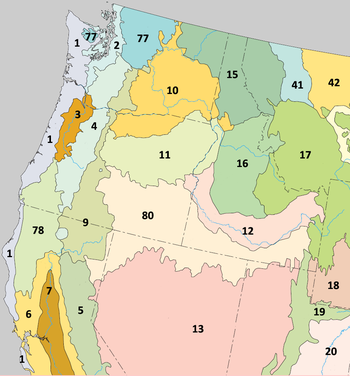
Eastern Cascades Slopes and Foothills (ecoregion)
Encyclopedia
United States Environmental Protection Agency
The U.S. Environmental Protection Agency is an agency of the federal government of the United States charged with protecting human health and the environment, by writing and enforcing regulations based on laws passed by Congress...
(EPA) in the U.S. states of Oregon
Oregon
Oregon is a state in the Pacific Northwest region of the United States. It is located on the Pacific coast, with Washington to the north, California to the south, Nevada on the southeast and Idaho to the east. The Columbia and Snake rivers delineate much of Oregon's northern and eastern...
, Washington, and California
California
California is a state located on the West Coast of the United States. It is by far the most populous U.S. state, and the third-largest by land area...
. In the rain shadow
Rain shadow
A rain shadow is a dry area on the lee side of a mountainous area. The mountains block the passage of rain-producing weather systems, casting a "shadow" of dryness behind them. As shown by the diagram to the right, the warm moist air is "pulled" by the prevailing winds over a mountain...
of the Cascade Range
Cascade Range
The Cascade Range is a major mountain range of western North America, extending from southern British Columbia through Washington and Oregon to Northern California. It includes both non-volcanic mountains, such as the North Cascades, and the notable volcanoes known as the High Cascades...
, the eastern side of the mountains experiences greater temperature extremes and receives less precipitation
Precipitation (meteorology)
In meteorology, precipitation In meteorology, precipitation In meteorology, precipitation (also known as one of the classes of hydrometeors, which are atmospheric water phenomena is any product of the condensation of atmospheric water vapor that falls under gravity. The main forms of precipitation...
than the west side. Open forests of ponderosa pine
Ponderosa Pine
Pinus ponderosa, commonly known as the Ponderosa Pine, Bull Pine, Blackjack Pine, or Western Yellow Pine, is a widespread and variable pine native to western North America. It was first described by David Douglas in 1826, from eastern Washington near present-day Spokane...
and some lodgepole pine
Lodgepole Pine
Lodgepole Pine, Pinus contorta, also known as Shore Pine, is a common tree in western North America. Like all pines, it is evergreen.-Subspecies:...
distinguish this region from the Cascades ecoregion
Cascades (ecoregion)
The Cascades ecoregion is a Level III ecoregion designated by the United States Environmental Protection Agency in the U.S. states of Washington, Oregon, and California...
, where hemlock
Tsuga
Tsuga is a genus of conifers in the family Pinaceae. The common name hemlock is derived from a perceived similarity in the smell of its crushed foliage to that of the unrelated plant poison hemlock....
and fir
Fir
Firs are a genus of 48–55 species of evergreen conifers in the family Pinaceae. They are found through much of North and Central America, Europe, Asia, and North Africa, occurring in mountains over most of the range...
forests are more common, and from the lower, drier ecoregions to the east, where shrub
Shrub
A shrub or bush is distinguished from a tree by its multiple stems and shorter height, usually under 5–6 m tall. A large number of plants may become either shrubs or trees, depending on the growing conditions they experience...
s and grassland
Grassland
Grasslands are areas where the vegetation is dominated by grasses and other herbaceous plants . However, sedge and rush families can also be found. Grasslands occur naturally on all continents except Antarctica...
s are predominant. The vegetation
Vegetation
Vegetation is a general term for the plant life of a region; it refers to the ground cover provided by plants. It is a general term, without specific reference to particular taxa, life forms, structure, spatial extent, or any other specific botanical or geographic characteristics. It is broader...
is adapted to the prevailing dry, continental climate
Continental climate
Continental climate is a climate characterized by important annual variation in temperature due to the lack of significant bodies of water nearby...
and frequent wildfire
Wildfire
A wildfire is any uncontrolled fire in combustible vegetation that occurs in the countryside or a wilderness area. Other names such as brush fire, bushfire, forest fire, desert fire, grass fire, hill fire, squirrel fire, vegetation fire, veldfire, and wilkjjofire may be used to describe the same...
. Volcanic cone
Volcanic cone
Volcanic cones are among the simplest volcanic formations. They are built by ejecta from a volcanic vent, piling up around the vent in the shape of a cone with a central crater. Volcanic cones are of different types, depending upon the nature and size of the fragments ejected during the eruption...
s and butte
Butte
A butte is a conspicuous isolated hill with steep, often vertical sides and a small, relatively flat top; it is smaller than mesas, plateaus, and table landform tables. In some regions, such as the north central and northwestern United States, the word is used for any hill...
s are common in much of the region.
The Eastern Cascades Slopes and Foothills ecoregion has been subdivided into ten Level IV ecoregions, as described below. Level IV mapping is not yet complete in California, and the information below includes only the sections in Washington and Oregon.
Level IV ecoregions
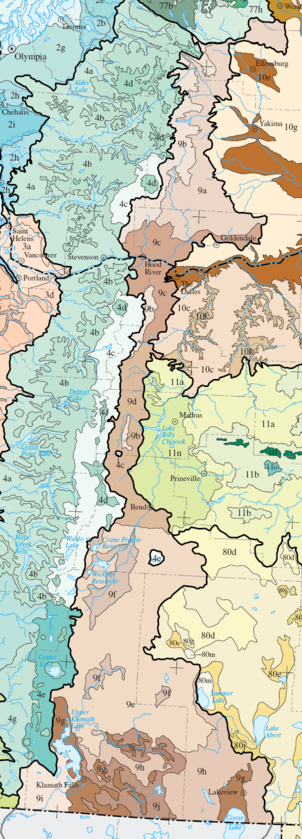
Yakima Plateau and Slopes (9a)
The high, unglaciatedGlacier
A glacier is a large persistent body of ice that forms where the accumulation of snow exceeds its ablation over many years, often centuries. At least 0.1 km² in area and 50 m thick, but often much larger, a glacier slowly deforms and flows due to stresses induced by its weight...
Yakima Plateau and Slopes ecoregion is characterized by plateau
Plateau
In geology and earth science, a plateau , also called a high plain or tableland, is an area of highland, usually consisting of relatively flat terrain. A highly eroded plateau is called a dissected plateau...
s, buttes, and canyon
Canyon
A canyon or gorge is a deep ravine between cliffs often carved from the landscape by a river. Rivers have a natural tendency to reach a baseline elevation, which is the same elevation as the body of water it will eventually drain into. This forms a canyon. Most canyons were formed by a process of...
s, with medium to high gradient permanent and intermittent stream
Stream
A stream is a body of water with a current, confined within a bed and stream banks. Depending on its locale or certain characteristics, a stream may be referred to as a branch, brook, beck, burn, creek, "crick", gill , kill, lick, rill, river, syke, bayou, rivulet, streamage, wash, run or...
s and river
River
A river is a natural watercourse, usually freshwater, flowing towards an ocean, a lake, a sea, or another river. In a few cases, a river simply flows into the ground or dries up completely before reaching another body of water. Small rivers may also be called by several other names, including...
s on a surface of basalt
Basalt
Basalt is a common extrusive volcanic rock. It is usually grey to black and fine-grained due to rapid cooling of lava at the surface of a planet. It may be porphyritic containing larger crystals in a fine matrix, or vesicular, or frothy scoria. Unweathered basalt is black or grey...
. Natural springs
Spring (hydrosphere)
A spring—also known as a rising or resurgence—is a component of the hydrosphere. Specifically, it is any natural situation where water flows to the surface of the earth from underground...
occur, especially in the south. Elevation varies from 2500 to 5000 feet (762 to 1524 m). The dry continental climate supports open woodland
Woodland
Ecologically, a woodland is a low-density forest forming open habitats with plenty of sunlight and limited shade. Woodlands may support an understory of shrubs and herbaceous plants including grasses. Woodland may form a transition to shrubland under drier conditions or during early stages of...
s dominated by ponderosa pine and bitterbrush, with some Douglas-fir
Douglas-fir
Douglas-fir is one of the English common names for evergreen coniferous trees of the genus Pseudotsuga in the family Pinaceae. Other common names include Douglas tree, and Oregon pine. There are five species, two in western North America, one in Mexico, and two in eastern Asia...
and Oregon white oak. Fire is an integral part of the ecosystem
Ecosystem
An ecosystem is a biological environment consisting of all the organisms living in a particular area, as well as all the nonliving , physical components of the environment with which the organisms interact, such as air, soil, water and sunlight....
. The region covers 1793 square miles (4,644 km²) in Washington, mainly on land belonging to the Yakama Nation.
Grand Fir Mixed Forest (9b)
The Grand Fir Mixed Forest ecoregion is characterized by high, glaciated plateaus, mountainMountain
Image:Himalaya_annotated.jpg|thumb|right|The Himalayan mountain range with Mount Everestrect 58 14 160 49 Chomo Lonzorect 200 28 335 52 Makalurect 378 24 566 45 Mount Everestrect 188 581 920 656 Tibetan Plateaurect 250 406 340 427 Rong River...
s, and canyons containing high gradient streams and rivers. Scattered lake
Lake
A lake is a body of relatively still fresh or salt water of considerable size, localized in a basin, that is surrounded by land. Lakes are inland and not part of the ocean and therefore are distinct from lagoons, and are larger and deeper than ponds. Lakes can be contrasted with rivers or streams,...
s occur in glacial rock basins. Elevation varies from 2200 to 6500 feet (671 to 1829 m). The frigid soil
Soil
Soil is a natural body consisting of layers of mineral constituents of variable thicknesses, which differ from the parent materials in their morphological, physical, chemical, and mineralogical characteristics...
s and snowy, continental climate support a mix of grand fir
Grand Fir
Abies grandis is a fir native to the Pacific Northwest and Northern California of North America, occurring at altitudes of sea level to 1,800 m...
and Douglas-fir, with some ponderosa pine and western larch
Western Larch
Western Larch is a species of larch native to the mountains of western North America, in Canada in southeastern British Columbia and southwestern Alberta, and in the United States in eastern Washington, eastern Oregon, northern Idaho and western Montana.It is a large deciduous coniferous tree...
. Plants in the understory
Understory
Understory is the term for the area of a forest which grows at the lowest height level below the forest canopy. Plants in the understory consist of a mixture of seedlings and saplings of canopy trees together with understory shrubs and herbs...
include vine maple
Vine Maple
Acer circinatum is a species of maple native to western North America, from southwest British Columbia to northern California, always within 300 km of the Pacific Ocean coast....
, hazel
Hazel
The hazels are a genus of deciduous trees and large shrubs native to the temperate northern hemisphere. The genus is usually placed in the birch family Betulaceae, though some botanists split the hazels into a separate family Corylaceae.They have simple, rounded leaves with double-serrate margins...
, snowberry, and oceanspray. The region covers 812 square miles (2,103 km²) in Washington and 162 square miles (420 km²) in Oregon, on the eastern slopes of Mount Rainier
Mount Rainier
Mount Rainier is a massive stratovolcano located southeast of Seattle in the state of Washington, United States. It is the most topographically prominent mountain in the contiguous United States and the Cascade Volcanic Arc, with a summit elevation of . Mt. Rainier is considered one of the most...
, Mount Adams
Mount Adams (Washington)
Mount Adams is a potentially activestratovolcano in the Cascade Range and the second-highest mountain in the U.S. state of Washington.Adams is a member of the Cascade Volcanic Arc, and is one of the arc's largest volcanoes,...
, and Mount Hood
Mount Hood
Mount Hood, called Wy'east by the Multnomah tribe, is a stratovolcano in the Cascade Volcanic Arc of northern Oregon. It was formed by a subduction zone and rests in the Pacific Northwest region of the United States...
, and on Black Butte
Black Butte (Oregon)
Black Butte is a cinder cone butte located in Deschutes National Forest, northwest of the town of Sisters, Oregon. An extinct volcano, it is composed of basaltic andesite. The cone rises over the surrounding plateau. Black Butte is a striking feature just north of US Highway 20, which descends...
. It contains land belonging to the Yakama Nation and public land within the Wenatchee
Wenatchee National Forest
Wenatchee National Forest is a U.S. National Forest located in Washington. With an area of 1,735,394 acres , it extends about 137 miles along the eastern slopes of the Cascade Range of Washington, USA from Okanogan National Forest to Gifford Pinchot National Forest...
, Gifford Pinchot
Gifford Pinchot National Forest
Gifford Pinchot National Forest is a U.S. National Forest located in southern Washington, USA. With an area of 1.37 million acres , it extends 116 km along the western slopes of Cascade Range from Mount Rainier National Park to the Columbia River. It includes the 110,000 acre Mount St....
, Deschutes
Deschutes National Forest
The Deschutes National Forest is a United States National Forest located in parts of Deschutes, Klamath, Lake, and Jefferson counties in central Oregon. It comprises 1.8 million acres along the east side of the Cascade mountains. In 1908, the Deschutes National Forest was established from parts...
, and Mount Hood National Forest
Mount Hood National Forest
The Mount Hood National Forest is located east of the city of Portland, Oregon, and the northern Willamette River valley. The Forest extends south from the Columbia River Gorge across more than of forested mountains, lakes and streams to the Olallie Scenic Area, a high lake basin under the slopes...
s (including the Badger Creek Wilderness
Badger Creek Wilderness
The Badger Creek Wilderness is a wilderness area located east of Mount Hood in the northwestern Cascades of Oregon, United States. It is one of six designated wilderness areas in the Mount Hood National Forest; the others being Mark O. Hatfield, Salmon-Huckleberry, Mount Hood, Mount Jefferson,...
).
Oak/Conifer Foothills (9c)
The Oak/Conifer Foothills ecoregion is lower and drier than the Grand Fir Mixed Forest and more diverseBiodiversity
Biodiversity is the degree of variation of life forms within a given ecosystem, biome, or an entire planet. Biodiversity is a measure of the health of ecosystems. Biodiversity is in part a function of climate. In terrestrial habitats, tropical regions are typically rich whereas polar regions...
than other parts of the Eastern Cascades. It consists of foothills, low mountains, plateaus, and valleys from 500 to 3500 feet (152 to 1067 m). Marine weather
Oceanic climate
An oceanic climate, also called marine west coast climate, maritime climate, Cascadian climate and British climate for Köppen climate classification Cfb and subtropical highland for Köppen Cfb or Cwb, is a type of climate typically found along the west coasts at the middle latitudes of some of the...
enters the region via the Columbia River Gorge
Columbia River Gorge
The Columbia River Gorge is a canyon of the Columbia River in the Pacific Northwest of the United States. Up to deep, the canyon stretches for over as the river winds westward through the Cascade Range forming the boundary between the State of Washington to the north and Oregon to the south...
, moderating the otherwise continental climate. As a result, soil, climate, and vegetation share characteristics of both eastern
Eastern Oregon
Eastern Oregon is the eastern part of the U.S. state of Oregon. It is not an officially recognized geographic entity, thus the boundaries of the region vary according to context. It is sometimes understood to include only the eight easternmost counties in the state; in other contexts, it includes...
and western Oregon
Western Oregon
Western Oregon is a geographical term that is generally taken to mean the part of Oregon within 120 miles of the Oregon Coast, on the west side of the crest of the Cascade Range. The term is applied somewhat loosely however, and is sometimes taken to exclude the southwestern areas of the state,...
. The region is characterized by Oregon white oak woodlands and ponderosa pine forests in the east and Douglas-fir and western hemlock
Western Hemlock
Tsuga heterophylla. the Western Hemlock, is a species of hemlock native to the west coast of North America, with its northwestern limit on the Kenai Peninsula, Alaska, and its southeastern limit in northern Sonoma County, California.-Habitat:...
forests in the west. Some grassland
Grassland
Grasslands are areas where the vegetation is dominated by grasses and other herbaceous plants . However, sedge and rush families can also be found. Grasslands occur naturally on all continents except Antarctica...
s also occur. Understory plants include Idaho fescue, bluebunch wheatgrass
Bluebunch wheatgrass
Pseudoroegneria spicata is a species of grass known by the common name Bluebunch Wheatgrass. This native western North American perennial bunchgrass is known by the scientific synonyms Elymus spicatus and Agropyron spicatum. The grass can be found from Alaska to Texas. It occurs in many types of...
, antelope bitterbrush, Oregon grape, hazel, and snowberry. Common land uses include forestry
Forestry
Forestry is the interdisciplinary profession embracing the science, art, and craft of creating, managing, using, and conserving forests and associated resources in a sustainable manner to meet desired goals, needs, and values for human benefit. Forestry is practiced in plantations and natural stands...
, recreation
Recreation
Recreation is an activity of leisure, leisure being discretionary time. The "need to do something for recreation" is an essential element of human biology and psychology. Recreational activities are often done for enjoyment, amusement, or pleasure and are considered to be "fun"...
, grazing
Grazing
Grazing generally describes a type of feeding, in which a herbivore feeds on plants , and also on other multicellular autotrophs...
, rural residential development, orchard
Orchard
An orchard is an intentional planting of trees or shrubs that is maintained for food production. Orchards comprise fruit or nut-producing trees which are grown for commercial production. Orchards are also sometimes a feature of large gardens, where they serve an aesthetic as well as a productive...
s, and, in the valleys, grain and hay farming. The land is mostly privately owned. The region covers 563 square miles (1,458 km²) in Washington and 461 square miles (1,194 km²) in Oregon along the Columbia River
Columbia River
The Columbia River is the largest river in the Pacific Northwest region of North America. The river rises in the Rocky Mountains of British Columbia, Canada, flows northwest and then south into the U.S. state of Washington, then turns west to form most of the border between Washington and the state...
corridor, including the lower reaches of the White Salmon
White Salmon River
The White Salmon River is a river flowing into the Columbia River Gorge, originating on the slopes of Mount Adams. The lower portion of the river is in the Columbia River Gorge National Scenic Area and some of the upper sections are part of the National Wild and Scenic Rivers system...
and Klickitat River
Klickitat River
The Klickitat River is a tributary of the Columbia River, approximately long, in south-central Washington in the United States. It drains a rugged plateau area on the eastern side of the Cascade Range northeast of Portland, Oregon...
drainages.
Ponderosa Pine/Bitterbrush Woodland (9d)
The Ponderosa Pine/Bitterbrush Woodland ecoregion has a terrain dominated by high, undulating volcanic plateaus and canyons, with permanent, medium gradient streams. Elevation varies from 2400 to 5200 feet (732 to 1585 m). Stream flow is consistent year-round, due to the volcanic hydrogeologyHydrogeology
Hydrogeology is the area of geology that deals with the distribution and movement of groundwater in the soil and rocks of the Earth's crust, . The term geohydrology is often used interchangeably...
. The well-drained, frigid soils are derived from Mazama Ash
Mazama Ash
The Mazama Ash is a large geologically recent volcanic ash deposit that covers portions of the U.S. states of California, Oregon, Washington, Idaho, Montana, Nevada, Wyoming and Utah, as well as the Canadian provinces of British Columbia, Alberta and southwestern Saskatchewan...
, which was produced by the catastrophic eruption of Mount Mazama
Mount Mazama
Mount Mazama is a destroyed stratovolcano in the Oregon part of the Cascade Volcanic Arc and the Cascade Range. The volcano's collapsed caldera holds Crater Lake, and the entire mountain is located within Crater Lake National Park....
about 6,845 years ago, and support nearly homogenous stands of ponderosa pine. Historically, frequent fires burned undergrowth, creating open groves of pines. Lodgepole pine is largely absent here. Understory vegetation varies with elevation; at lower elevations, antelope bitterbrush is important winter browse for deer
Deer
Deer are the ruminant mammals forming the family Cervidae. Species in the Cervidae family include white-tailed deer, elk, moose, red deer, reindeer, fallow deer, roe deer and chital. Male deer of all species and female reindeer grow and shed new antlers each year...
. At higher elevations, greenleaf manzanita and snowberry are found. Riparian areas
Riparian zone
A riparian zone or riparian area is the interface between land and a river or stream. Riparian is also the proper nomenclature for one of the fifteen terrestrial biomes of the earth. Plant habitats and communities along the river margins and banks are called riparian vegetation, characterized by...
support mountain alder, stream dogwood, willow
Willow
Willows, sallows, and osiers form the genus Salix, around 400 species of deciduous trees and shrubs, found primarily on moist soils in cold and temperate regions of the Northern Hemisphere...
s, and sedges. The region covers 1077 square miles (2,789 km²) in Oregon, east of Mount Jefferson
Mount Jefferson (Oregon)
Mount Jefferson is a stratovolcano in the Cascade Volcanic Arc, part of the Cascade Range, and is the second highest mountain in Oregon. Situated in the far northeastern corner of Linn County on the Jefferson County line, about east of Corvallis, Mount Jefferson is in a rugged wilderness and is...
, Three-Fingered Jack, and the Three Sisters
Three Sisters (Oregon)
The Three Sisters are three volcanic peaks of the Cascade Volcanic Arc and the Cascade Range in Oregon, each of which exceeds in elevation. They are the third, fourth, and fifth highest peaks in the state of Oregon and are located in the Three Sisters Wilderness, about southwest from the nearest...
, in the Deschutes National Forest
Deschutes National Forest
The Deschutes National Forest is a United States National Forest located in parts of Deschutes, Klamath, Lake, and Jefferson counties in central Oregon. It comprises 1.8 million acres along the east side of the Cascade mountains. In 1908, the Deschutes National Forest was established from parts...
and on the Warm Springs Indian Reservation
Warm Springs Indian Reservation
The Warm Springs Indian Reservation consists of 1,019.385 sq mi in north central Oregon, in the United States, and is occupied and governed by the Confederated Tribes of Warm Springs.-Tribes:...
.
Pumice Plateau (9e)
The Pumice Plateau ecoregion is a high volcanic plateau, characteristically covered by thick deposits of Mount Mazama ash and pumicePumice
Pumice is a textural term for a volcanic rock that is a solidified frothy lava typically created when super-heated, highly pressurized rock is violently ejected from a volcano. It can be formed when lava and water are mixed. This unusual formation is due to the simultaneous actions of rapid...
. Elevation varies from 4200 to 8300 feet (1280 to 2530 m). Residual soils are very deep, highly permeable, and subject to drought
Drought
A drought is an extended period of months or years when a region notes a deficiency in its water supply. Generally, this occurs when a region receives consistently below average precipitation. It can have a substantial impact on the ecosystem and agriculture of the affected region...
, with intermittent, low to medium gradient streams and spring-fed creeks
Stream
A stream is a body of water with a current, confined within a bed and stream banks. Depending on its locale or certain characteristics, a stream may be referred to as a branch, brook, beck, burn, creek, "crick", gill , kill, lick, rill, river, syke, bayou, rivulet, streamage, wash, run or...
and marsh
Marsh
In geography, a marsh, or morass, is a type of wetland that is subject to frequent or continuous flood. Typically the water is shallow and features grasses, rushes, reeds, typhas, sedges, other herbaceous plants, and moss....
es. Freezing temperatures are possible any time of year. Ponderosa pine forests are common on slopes, with white fir
White Fir
White Fir is a fir native to the mountains of western North America, occurring at altitudes of 900-3,400 m. It is a medium to large evergreen coniferous tree growing to 25–60 m tall and with a trunk diameter of up to 2 m . It is popular as an ornamental landscaping tree and as a Christmas Tree...
at higher elevations. Colder depressions
Depression (geology)
A depression in geology is a landform sunken or depressed below the surrounding area. Depressions may be formed by various mechanisms.Structural or tectonic related:...
and flats, where pumice deposits are thickest, are dominated by lodgepole pine, with an understory of antelope bitterbrush and Idaho fescue. Riparian areas support mountain alder, stream dogwood, willows, and quaking aspen. The Pumice Plateau is the largest of the Eastern Cascades subregions, covering 4236 square miles (10,971 km²) in Oregon between Bend
Bend, Oregon
Bend is a city in and the county seat of Deschutes County, Oregon, United States, and the principal city of the Bend, Oregon Metropolitan Statistical Area. Bend is Central Oregon's largest city, and, despite its modest size, is the de facto metropolis of the region, owing to the low population...
and Klamath Falls
Klamath Falls, Oregon
Klamath Falls is a city in Klamath County, Oregon, United States. Originally called Linkville when George Nurse founded the town in 1867, after the Link River on whose falls this city sat, although no falls currently exist; the name was changed to Klamath Falls in 1892...
. It contains extensive areas within the Deschutes
Deschutes National Forest
The Deschutes National Forest is a United States National Forest located in parts of Deschutes, Klamath, Lake, and Jefferson counties in central Oregon. It comprises 1.8 million acres along the east side of the Cascade mountains. In 1908, the Deschutes National Forest was established from parts...
and Fremont-Winema National Forests
Fremont-Winema National Forests
The Fremont–Winema National Forests are two United States National Forests, Fremont National Forest and Winema National Forest, that were administratively combined in 2002. They cover territory in southern Oregon from the crest of the Cascades on the west, past the city of Lakeview to the east. ...
(including the Gearhart Mountain Wilderness
Gearhart Mountain Wilderness
Gearhart Mountain Wilderness is a wilderness area located within the Fremont National Forest in Lake County and Klamath County, south-central Oregon. This area was established in 1943 as a Wild Area and designated as Wilderness with the Wilderness Act of 1964. In 1984, an additional were added...
) and the lower elevations of the Newberry National Volcanic Monument
Newberry National Volcanic Monument
Newberry National Volcanic Monument was designated on November 5, 1990, to protect the area around the Newberry Volcano in the United States. It was created within the boundaries of the Deschutes National Forest and is managed by the U.S. Forest Service...
.
Cold Wet Pumice Plateau Basins (9f)
The Cold Wet Pumice Plateau Basins ecoregion includes Sycan Marsh, Klamath Marsh, and La Pine Basin, which are surrounded by the Pumice Plateau but have distinct vegetation and topographyTopography
Topography is the study of Earth's surface shape and features or those ofplanets, moons, and asteroids...
. At an elevation of 4100 to 5200 feet (1250 to 1585 m), they function as cold air catch-basins during the winter, which results in lower minimum temperatures. Soils in the basin
Depression (geology)
A depression in geology is a landform sunken or depressed below the surrounding area. Depressions may be formed by various mechanisms.Structural or tectonic related:...
s have water table
Water table
The water table is the level at which the submarine pressure is far from atmospheric pressure. It may be conveniently visualized as the 'surface' of the subsurface materials that are saturated with groundwater in a given vicinity. However, saturated conditions may extend above the water table as...
s at or near the surface for significant periods of the year, in contrast to the soils of the Pumice Plateau. The La Pine Basin is underlain by thick lacustrine
Lake
A lake is a body of relatively still fresh or salt water of considerable size, localized in a basin, that is surrounded by land. Lakes are inland and not part of the ocean and therefore are distinct from lagoons, and are larger and deeper than ponds. Lakes can be contrasted with rivers or streams,...
deposits that exhibit high groundwater
Groundwater
Groundwater is water located beneath the ground surface in soil pore spaces and in the fractures of rock formations. A unit of rock or an unconsolidated deposit is called an aquifer when it can yield a usable quantity of water. The depth at which soil pore spaces or fractures and voids in rock...
levels during the spring snowmelt
Snowmelt
In hydrology, snowmelt is surface runoff produced from melting snow. It can also be used to describe the period or season during which such runoff is produced. Water produced by snowmelt is an important part of the annual water cycle in many parts of the world, in some cases contributing high...
. It supports lodgepole pine stands, as well as wet, forested wetland
Wetland
A wetland is an area of land whose soil is saturated with water either permanently or seasonally. Wetlands are categorised by their characteristic vegetation, which is adapted to these unique soil conditions....
s of lodgepole pine, willow, and aspen. Scattered ponderosa pine shrub forest is found on the driest soils. The Sycan and Klamath marshes support wetland meadow
Meadow
A meadow is a field vegetated primarily by grass and other non-woody plants . The term is from Old English mædwe. In agriculture a meadow is grassland which is not grazed by domestic livestock but rather allowed to grow unchecked in order to make hay...
vegetation, including tule
Tule
Schoenoplectus acutus , called tule , common tule, hardstem tule, tule rush, hardstem bulrush, or viscid bulrush, is a giant species of sedge in the plant family Cyperaceae, native to freshwater marshes all over North America...
s and tufted hairgrass. Marshes, lakes, reservoir
Reservoir
A reservoir , artificial lake or dam is used to store water.Reservoirs may be created in river valleys by the construction of a dam or may be built by excavation in the ground or by conventional construction techniques such as brickwork or cast concrete.The term reservoir may also be used to...
s, wetland forests, and medium and low gradient rivers provide important habitat for migratory
Bird migration
Bird migration is the regular seasonal journey undertaken by many species of birds. Bird movements include those made in response to changes in food availability, habitat or weather. Sometimes, journeys are not termed "true migration" because they are irregular or in only one direction...
waterfowl
Waterfowl
Waterfowl are certain wildfowl of the order Anseriformes, especially members of the family Anatidae, which includes ducks, geese, and swans....
. The region covers 651 square miles (1,686 km²) in Oregon, a mixture of private and public lands, including the Deschutes and Fremont-Winema National Forests and the Klamath Marsh National Wildlife Refuge
Klamath Marsh National Wildlife Refuge
Klamath Marsh National Wildlife Refuge was established in 1958 when approximately were purchased from the Klamath tribe with Federal Duck Stamp Funds. In 1990 and 1998, additional acquisitions boosted Refuge acreage to 40,646...
.
Klamath/Goose Lake Warm Wet Basins (9g)
The Klamath/Goose Lake Warm Wet Basins ecoregion (named for Upper KlamathUpper Klamath Lake
Upper Klamath Lake is a large, shallow freshwater lake east of the Cascade Range in south central Oregon in the United States. The largest freshwater body in Oregon, it is approximately 20 mi long and 8 mi wide and extends northwest from the city of Klamath Falls...
and Goose
Goose Lake (Oregon-California)
Goose Lake is a large alkaline glacial lake located in the Goose Lake Valley on the Oregon-California border. The north end of the lake is in Lake County, Oregon and the south end is in Modoc County, California. The mountains at the north end of the lake are part of the Fremont National Forest...
lakes) is drier than elsewhere in the eastern Cascades, yet it contains floodplain
Floodplain
A floodplain, or flood plain, is a flat or nearly flat land adjacent a stream or river that stretches from the banks of its channel to the base of the enclosing valley walls and experiences flooding during periods of high discharge...
s, terraces
Stream terrace
Fluvial terraces are elongated terraces that flank the sides of floodplains and fluvial valleys all over the world. They consist of a relatively level strip of land, called a “tread,” separated from either an adjacent floodplain, other fluvial terraces, or uplands by distinctly steeper strips of...
, and a pluvial lake
Pluvial lake
A pluvial lake is a landlocked basin which fills with rainwater during times of glaciation, when precipitation is higher. Pluvial lakes that have since evaporated and dried out may also be referred to as paleolakes.-Geology:...
basin. Elevation varies from 4000 to 5400 feet (1219 to 1646 m). A variety of wildrye, bluegrass
Poa
Poa is a genus of about 500 species of grasses, native to the temperate regions of both hemispheres. Common names include meadow-grass , bluegrass , tussock , and speargrass. "Poa" is Greek for fodder...
, and wheatgrass
Wheatgrass (disambiguation)
Wheatgrass may refer to:* Wheatgrass, grass, juice, tablet or powder of the young common wheat plant, grown for human consumption* Agropyron, a genus known as crested-wheat grasses* Elymus, a genus of wild rye, sometimes called wheatgrass...
species once covered the basins, but most of the wet meadows and wetlands have been drained for rural residential development, pasture
Pasture
Pasture is land used for grazing. Pasture lands in the narrow sense are enclosed tracts of farmland, grazed by domesticated livestock, such as horses, cattle, sheep or swine. The vegetation of tended pasture, forage, consists mainly of grasses, with an interspersion of legumes and other forbs...
, and cropland, including alfalfa
Alfalfa
Alfalfa is a flowering plant in the pea family Fabaceae cultivated as an important forage crop in the US, Canada, Argentina, France, Australia, the Middle East, South Africa, and many other countries. It is known as lucerne in the UK, France, Australia, South Africa and New Zealand, and known as...
, potatoes, and small grains. Potential vegetation includes bluebunch wheatgrass
Bluebunch wheatgrass
Pseudoroegneria spicata is a species of grass known by the common name Bluebunch Wheatgrass. This native western North American perennial bunchgrass is known by the scientific synonyms Elymus spicatus and Agropyron spicatum. The grass can be found from Alaska to Texas. It occurs in many types of...
, Idaho fescue, antelope bitterbrush, big sagebrush, and low sagebrush
Artemisia arbuscula
Artemisia arbuscula is a species of sagebrush known by the common names little sagebrush, low sagebrush, or black sagebrush....
on the steppes, with tules, cattails, and sedges in the wetlands. Several marshland wildlife refuges within the Klamath Basin National Wildlife Refuges Complex
Klamath Basin National Wildlife Refuges Complex
The Klamath Basin National Wildlife Refuge Complex is a wildlife preserve operated by the United States Fish and Wildlife Service located in the Klamath Basin of southern Oregon and northern California near Klamath Falls, Oregon...
are key to preserving regional biodiversity
Biodiversity
Biodiversity is the degree of variation of life forms within a given ecosystem, biome, or an entire planet. Biodiversity is a measure of the health of ecosystems. Biodiversity is in part a function of climate. In terrestrial habitats, tropical regions are typically rich whereas polar regions...
, particularly at-risk bird and fish species. The region covers 1039 square miles (2,691 km²) in Klamath
Klamath County, Oregon
-National protected areas:* Bear Valley National Wildlife Refuge* Crater Lake National Park * Deschutes National Forest * Fremont National Forest * Klamath Marsh National Wildlife Refuge* Lower Klamath National Wildlife Refuge...
and Lake
Lake County, Oregon
Lake County is a county in the high desert south central region of the U.S. state of Oregon, so named for the many lakes found within its boundaries, including Lake Abert, Hart Lake Reservoir, and Goose Lake. While Lake is among Oregon's largest counties, it is sparsely populated with 7,895...
counties, Oregon. Contiguous areas in California have not been mapped yet.
Fremont Pine/Fir Forest (9h)
The Fremont Pine/Fir Forest ecoregion contains steeply to moderately sloping mountains and high plateaus that rarely exceed timberline. Elevation varies from 5000 to 8000 feet (1524 to 2439 m). Residual soils are common in the region, in contrast to the Pumice Plateau, where soils have been deeply buried by pumice and ash. Reservoirs, a few glacial rock-basin lakes, many springs, and high gradient intermittent and ephemeral streams occur. The continental climate and diverse terrain support a range of vegetation types. Ponderosa pine and western juniper woodlands are common at lower elevations. White fir, sugar pineSugar Pine
Pinus lambertiana, commonly known as the sugar pine or sugar cone pine, is the tallest and most massive pine, with the longest cones of any conifer...
, whitebark pine
Whitebark Pine
Pinus albicaulis, known commonly as Whitebark Pine, Pitch Pine, Scrub Pine, and Creeping Pine occurs in the mountains of the Western United States and Canada, specifically the subalpine areas of the Sierra Nevada, the Cascade Range, the Pacific Coast Ranges, and the northern Rocky Mountains –...
, lodgepole pine, and California incense-cedar are found on north slopes and at higher elevations. Understory plants include snowberry, heartleaf arnica, Wheeler bluegrass, antelope bitterbrush, and longstolon sedge. The region covers 1672 square miles (4,330 km²) in Oregon, mainly on public land within the Fremont-Winema National Forest. Contiguous areas in California have not been mapped yet.
Southern Cascades Slope (9i)
The Southern Cascades Slope ecoregion is a transitional zone between the Cascades ecoregionCascades (ecoregion)
The Cascades ecoregion is a Level III ecoregion designated by the United States Environmental Protection Agency in the U.S. states of Washington, Oregon, and California...
and the drier Eastern Cascade Slopes and Foothills, characterized by moderately sloping mountains with medium to high gradient streams. Elevation varies from 3600 to 6300 feet (1097 to 1920 m). It is higher than other subregions in the Eastern Cascades and typically receives greater precipitation. Forests of ponderosa pine blanket the mountainous landscape; white fir, Shasta red fir, Douglas-fir, and incense cedar grow at higher elevations. Understory plants include Idaho fescue, antelope bitterbrush, Ross' sedge, western fescue, snowberry, and golden chinkapin. The region covers 515 square miles (1,334 km²) in Oregon, south of Aspen Butte
Aspen Butte
Aspen Butte is a steep-sided shield volcano in the Cascade Range of southern Oregon. It is located south of Pelican Butte and southeast of Mount McLoughlin. It rises over above the nearby shore of Upper Klamath Lake...
in the Klamath River
Klamath River
The Klamath River is an American river that flows southwest through Oregon and northern California, cutting through the Cascade Range to empty into the Pacific Ocean. The river drains an extensive watershed of almost that stretches from the high desert country of the Great Basin to the temperate...
watershed, including Bear Valley National Wildlife Refuge
Bear Valley National Wildlife Refuge
The Bear Valley National Wildlife Refuge is a wildlife refuge located in the southwestern part of Klamath County, Oregon, near the California border. It was established in 1978 to protect the nesting areas of Bald Eagles...
. Contiguous areas in California have not been mapped yet.
Klamath Juniper Woodland (9j)
The Klamath Juniper Woodland ecoregion is composed of undulating hills, benches, and escarpmentEscarpment
An escarpment is a steep slope or long cliff that occurs from erosion or faulting and separates two relatively level areas of differing elevations.-Description and variants:...
s covered with a mosaic of rangeland
Rangeland
Rangelands are vast natural landscapes in the form of grasslands, shrublands, woodlands, wetlands, and deserts. Types of rangelands include tallgrass and shortgrass prairies, desert grasslands and shrublands, woodlands, savannas, chaparrals, steppes, and tundras...
and woodland, at an elevation of 4400 to 6200 feet (1341 to 1890 m). Mean annual precipitation ranges from 12 to 20 inches (30 to 51 cm) per year. Western juniper grows on shallow, rocky soils with an understory of low sagebrush, Wyoming big sagebrush, bitterbrush, and bunchgrasses. Several species found in the shrub-steppe
Shrub-steppe
Shrub-steppe is a type of low rainfall natural grassland. Shrub-steppes are distinguishable from deserts, which are too dry to support a noticeable cover of perennial grasses or other shrubs, while the shrub-steppe has sufficient moisture levels to support a cover of perennial grasses and/or...
grasslands are uncommon in eastern Oregon, such as woolly wyethia, Klamath plum, and birchleaf mountain-mahogany. The diverse shrublands provide important wildlife habitat. Reservoirs dot the landscape and are important to lowland irrigation
Irrigation
Irrigation may be defined as the science of artificial application of water to the land or soil. It is used to assist in the growing of agricultural crops, maintenance of landscapes, and revegetation of disturbed soils in dry areas and during periods of inadequate rainfall...
. The region covers 784 square miles (2,031 km²) in Oregon, south of Klamath Falls in the Lost River
Lost River (California)
Lost River begins and ends in a closed basin in northern California and southwestern Oregon in the United States. The river, long, flows in an arc from Clear Lake Reservoir in Modoc County, California, through Klamath County, Oregon to Tule Lake in Siskiyou County...
watershed, a mixture of public and private land. Contiguous areas in California have not been mapped yet.
See also
- Ecoregions defined by the EPA and the Commission for Environmental CooperationCommission for Environmental CooperationThe Commission for Environmental Cooperation was established by Canada, Mexico, and the United States to implement the North American Agreement on Environmental Cooperation , the environmental side accord to the North American Free Trade Agreement...
:- List of ecoregions in North America (CEC)
- List of ecoregions in the United States (EPA)
- List of ecoregions in Oregon
- List of ecoregions in Washington
- List of ecoregions in California
- The conservation group World Wildlife Fund maintains an alternate classification system:
- List of ecoregions (WWF)
- List of ecoregions in the United States (WWF)