
.gif)
Mount Adams (Washington)
Encyclopedia
Mount Adams is a potentially active
stratovolcano
in the Cascade Range
and the second-highest mountain
in the U.S. state
of Washington.
Adams is a member of the Cascade Volcanic Arc
, and is one of the arc's largest volcanoes,
located in a remote wilderness approximately 31 miles (50 km) east of Mount St. Helens
.
The Mount Adams Wilderness
comprises the upper and western part of the volcano's cone. The eastern side of the mountain is part of the Yakama Nation.
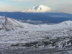
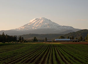
Adams' asymmetrical and broad body rises 1.5 miles (2.4 km) above the Cascade crest. Its nearly flat summit was formed as a result of cone-building eruptions from separated vents. Air travelers flying the busy routes above the area sometimes confuse Mount Adams with nearby Mount Rainier
, which has a similar flat-topped shape.
The Pacific Crest Trail
traverses the western flank of the mountain.
Although Adams has not erupted in over 1,400 years, it is not considered extinct.
. The Pinnacle forms the northwest false summit and was created by erosion from Adams and White Salmon glaciers. The summit crater is filled with snow and is open on its west rim.
Glaciers cover a total of 2.5% of Adams' surface but during the last ice age
about 90% of the mountain was glaciated. Most of the largest remaining glaciers (including the Adams, Klickitat, Lyman, and White Salmon) originate from Adams' summit ice cap. On the northwest face of the mountain, Adams Glacier
cascades down a steep channel in a series of icefall
s before spreading out and terminating at around the 7000 feet (2,133.6 m). Klickitat Glacier on the volcano's eastern flank originates in a 1 miles (1.6 km) wide cirque
and is fed by two smaller glaciers from the summit ice cap. It terminates around 6000 feet (1,828.8 m). In the Cascades, Adams Glacier is second in size only to Carbon Glacier
on Mount Rainier.
The total glacier area on Mount Adams decreased 49%, from 31.5 square kilometres (12.2 sq mi) to 16.2 square kilometres (6.3 sq mi), between 1904 and 2006.
es. The largest flank volcano is a basalt
ic shield volcano
on Adams east base called Goat Butte. This structure is at least 150,000 years old.
Little Mount Adams is a symmetrical cinder cone on top of the Ridge of Wonders on Adams' southeast flank.
Potato Hill is a cinder cone on Adams' north side that was created in the late Pleistocene and stands 800 feet (243.8 m) above its lava plain.
Lavas from its base flowed into the Cispus Valley where they were later modified by glaciers. At the 7500 feet (2,286 m) level on Adams' south flank is South Butte. The lavas associated with this structure are all younger than Suksdorf Ridge but were emplaced before the end of the ice age.
Located a few miles north of Adams is Goat Rocks Wilderness
and the heavily eroded ruins of a stratovolcano that is much older than Adams. Unlike Adams, the Goat Rocks
volcano was periodically explosive and deposited ash 2.5 million years ago that later solidified into 2100 feet (640.1 m) thick tuff
layers.
In the area surrounding Mount Adams, many underground caves have formed around inactive lava vents. These caves are usually close to the surface and can be hundreds of feet deep and wide.
The Highline trail encircles Mount Adams and is approximately 35 miles (56.3 km) long. The trail is also known as the "Around the Mountain" trail. An 8 miles (12.9 km) section of the trail is on the Yakama Indian Reservation
, which requires special permits. Part of the Highline trail is coincident with the Pacific Crest Trail
.
in that category among the Cascade stratovolcanoes. Mount Adams was probably created by the subduction of the Juan de Fuca plate
, which is located just off the coast of the Pacific Northwest
.
Mount Adams was born in the relatively late Pleistocene
and grew in several pulses of mostly lava
-extruding eruptions. Each eruptive cycle was separated from one another by long periods of dormancy during which glaciers eroded the mountain to below 9000 feet (2,743.2 m). Potassium-argon dating
has identified two such eruptive periods; the first occurring 275,000 to 200,000 years ago and the second 150,000 to 100,000 years ago. Most of these eruptions and therefore most of the volcano, consist of lava flows with little tephra
. The loose material that makes up much of Adams' core is made of breccia
ted lava.
 Andesite
and basalt
flows formed a 20 to 200 ft (6.1 to 61 m) thick circle around the base of the Mount Adams, and filled existing depressions and ponded in valleys. Most of the volcano is made of andesite together with handful of dacite
and pyroclastic flow
s which erupted early in Adams' development. The present main cone was built when Adams was capped by a glacier system in the last ice age
. The lava that erupted was shattered when it came in contact with the ice and the cone interior is therefore made of easily eroded
andesite fragments. Since its construction, constant emissions of heat and caustic gases have transformed much of the rock into clay
s (mostly kaolinite
), iron oxide
s, sulfur
-rich compounds and quartz
.
The present eruptive cone above 7000 feet (2,133.6 m) was constructed sometime between 25,000 to 10,000 years ago. Since that time the volcano has erupted at least seven times, all of which were above 6500 feet (1,981.2 m) on the summit. One of the most recent flows issued from South Butte and created the 4.5 miles (7.2 km) long by 0.5 mile (0.80467 km) wide A.G. Aiken Lava Bed. This flow looks young but has 3,500 year old Mount St. Helens
ash on it meaning it is at least that old. The last lava known to have erupted from Adams are the 2,500 to 3,500 year old Muddy Fork lava flows.
The Trout Lake Mudflow is the youngest large debris flow
from Adams and the only large one since the end of the last Ice Age. The flow dammed Trout Creek and covered 25 miles (40 km) of the White Salmon River valley. Impounded water later formed Trout Lake. The Great Slide of 1921 started close to the headwall of the White Salmon Glacier and was the largest avalanche
on Adams in historic time. The slide fell about 1 miles (1.6 km) and its debris covered about 1 square miles (2.6 km²) of the upper Salt Creek area. Steam vents were reported active at the slide source for three years, leading to speculation that the event was started with a small steam explosion.
This was the only debris flow in Mount Adam's recorded history, but there are five known lahars.
Since then, thermal anomalies (hot spots) and gas emissions (including hydrogen sulfide
) have occurred especially on the summit plateau. This indicates that Adams is dormant, not extinct. It still has the potential to become active. Future eruptions from Adams will probably follow patterns set by previous events and will thus be flank lava flows of andesite or basalt. Since the interior of the main cone is little more than a pile of fragmented lava and hydrothermally-altered rock, there is a potential for very large landslides and other debris flows.
The Indian Heaven
volcanic field
is located between St. Helens and Adams. Its principal feature are an 18 miles (29 km) long linear zone of shield volcanoes, cinder cones, and flows with volumes of up to 23 cubic miles (95.9 km³). The shield volcanoes, which form the backbone of the volcanic field, are located on the northern and southern sides of the field. Mount St. Helens and Mount Adams are on the western and the eastern sides.
 Native Americans in the area have composed many legends concerning the three "smoking mountains" that guard the Columbia River
. According to the Bridge of the Gods
tale, Wy'east (Mount Hood
) and Pahto (Mount Adams; also called Paddo or Klickitat by native peoples) were the sons of the Great Spirit
. The brothers both competed for the love of the beautiful La-wa-la-clough (Mount St. Helens
). When La-wa-la-clough chose Pahto, Wy'east struck his brother hard so that Pahto's head was flattened and Wy'east took La-wa-la-clough from him (thus attempting to explain Adams' squat appearance). Other versions of the story state that losing La-wa-la-clough caused Pahto such grief that he dropped his head in shame.
In 1805 the Lewis and Clark Expedition
recorded seeing the mountain. They misidentified it as Mount St. Helens which had been previously discovered and named. This is the earliest recorded sighting of the volcano by European explorers.
Between 1830 and 1834 Hall J. Kelley
led a campaign to rename the Cascade Range as the President's Range and also to rename each major Cascade mountain after a former President of the United States
. Mount Adams was not known to Kelley and was thus not in his plan. Mount Hood, in fact, was designated by Kelley to be renamed after President John Adams
but a mistake by a mapmaker placed the Mount Adams name north of Mount Hood and about 40 miles (60 km) east of Mount St. Helens. By sheer coincidence there was in fact a large mountain there to receive the name. Since the mountain had no official name at the time, Kelley's name stuck even though the rest of his plan failed.
In 1901, local settler and mountaineer C. E. Rusk led noted glaciologist Harry Reid to Adams' remote location. Reid conducted the first systematic study of the volcano and also named its most significant glacier
s.
In 1929 and 1931 Wade Dean filed mining claims to the sulfur
on Adams' 210 acre (0.8498406 km²) summit plateau. After building a horse and mule trail, he had a diamond-tipped drilling machine moved to the summit area and test pits were drilled. Although sulfur sludge was found, the amount and quality of the ore was never good enough to make the venture profitable and the project was abandoned in 1959. Adams is the only large Cascade volcano to have its summit exploited by commercial miners.
within the Gifford Pinchot National Forest
. The east side is part of the Yakama Nation. The wilderness is open to hiking
, backpacking
, mountain climbing and equestrian
sports. A Volcano Pass from the United States Forest Service
(USFS) is required for activities above a certain altitude.
Some areas of the Yakama Nation are open for recreation, while other areas are open only to members of the tribe.
The Conboy Lake National Wildlife Refuge
lies at the base of Mount Adams. The refuge covers 6500 acres (26.3 km²) and contains conifer forests, grasslands, and shallow wetlands. Protected wildlife includes deer
, elk
, beaver
, coyote
, otter
, small rodent
s, bald eagle
, greater sandhill crane
, and the Oregon spotted frog
.
On the slopes of the mountain, elk are common and wolverines have been sighted.
stratovolcano
Stratovolcano
A stratovolcano, also known as a composite volcano, is a tall, conical volcano built up by many layers of hardened lava, tephra, pumice, and volcanic ash. Unlike shield volcanoes, stratovolcanoes are characterized by a steep profile and periodic, explosive eruptions...
in the Cascade Range
Cascade Range
The Cascade Range is a major mountain range of western North America, extending from southern British Columbia through Washington and Oregon to Northern California. It includes both non-volcanic mountains, such as the North Cascades, and the notable volcanoes known as the High Cascades...
and the second-highest mountain
Mountain
Image:Himalaya_annotated.jpg|thumb|right|The Himalayan mountain range with Mount Everestrect 58 14 160 49 Chomo Lonzorect 200 28 335 52 Makalurect 378 24 566 45 Mount Everestrect 188 581 920 656 Tibetan Plateaurect 250 406 340 427 Rong River...
in the U.S. state
U.S. state
A U.S. state is any one of the 50 federated states of the United States of America that share sovereignty with the federal government. Because of this shared sovereignty, an American is a citizen both of the federal entity and of his or her state of domicile. Four states use the official title of...
of Washington.
Adams is a member of the Cascade Volcanic Arc
Cascade Volcanoes
The Cascade Volcanoes are a number of volcanoes in a volcanic arc in western North America, extending from southwestern British Columbia through Washington and Oregon to Northern California, a distance of well over 700 mi ...
, and is one of the arc's largest volcanoes,
located in a remote wilderness approximately 31 miles (50 km) east of Mount St. Helens
Mount St. Helens
Mount St. Helens is an active stratovolcano located in Skamania County, Washington, in the Pacific Northwest region of the United States. It is south of Seattle, Washington and northeast of Portland, Oregon. Mount St. Helens takes its English name from the British diplomat Lord St Helens, a...
.
The Mount Adams Wilderness
Mount Adams Wilderness
The Mount Adams Wilderness has of ecologically complex and geologically active land. Weather differs between the dry eastside and moist westside of the mountain. At , Mount Adams is one of the major Cascade mountains. The wilderness area is on the west side of the mountain and is part of the...
comprises the upper and western part of the volcano's cone. The eastern side of the mountain is part of the Yakama Nation.
Adams' asymmetrical and broad body rises 1.5 miles (2.4 km) above the Cascade crest. Its nearly flat summit was formed as a result of cone-building eruptions from separated vents. Air travelers flying the busy routes above the area sometimes confuse Mount Adams with nearby Mount Rainier
Mount Rainier
Mount Rainier is a massive stratovolcano located southeast of Seattle in the state of Washington, United States. It is the most topographically prominent mountain in the contiguous United States and the Cascade Volcanic Arc, with a summit elevation of . Mt. Rainier is considered one of the most...
, which has a similar flat-topped shape.
The Pacific Crest Trail
Pacific Crest Trail
The Pacific Crest Trail is a long-distance mountain hiking and equestrian trail on the Western Seaboard of the United States. The southern terminus is at the California border with Mexico...
traverses the western flank of the mountain.
Although Adams has not erupted in over 1,400 years, it is not considered extinct.
Summit area
Contrary to legend, the flatness of Adams' current summit area is not due to the loss of the volcano's peak. Instead it was formed as a result of cone-building eruptions from separated vents. A false summit rises 11500 feet (3,505.2 m) on the south side of the nearly half-mile (800 m) wide summit area. The true summit is about 800 feet (243.8 m) higher on the gently sloping north side. A small lava cone marks the highest point. Suksdorf Ridge is a long buttress trending from the false summit down to an elevation of 8000 feet (2,438.4 m). This structure was built by repeated lava flows in the late PleistocenePleistocene
The Pleistocene is the epoch from 2,588,000 to 11,700 years BP that spans the world's recent period of repeated glaciations. The name pleistocene is derived from the Greek and ....
. The Pinnacle forms the northwest false summit and was created by erosion from Adams and White Salmon glaciers. The summit crater is filled with snow and is open on its west rim.
Glaciers
Ice, mostly in the form of glaciers, covers about 6.2 square miles (16.1 km²) of the mountain's upper cone. Water from melting ice and rain slowly percolates through the very porous interior of the main cone and flows out through springs near the base of the volcano.Glaciers cover a total of 2.5% of Adams' surface but during the last ice age
Ice age
An ice age or, more precisely, glacial age, is a generic geological period of long-term reduction in the temperature of the Earth's surface and atmosphere, resulting in the presence or expansion of continental ice sheets, polar ice sheets and alpine glaciers...
about 90% of the mountain was glaciated. Most of the largest remaining glaciers (including the Adams, Klickitat, Lyman, and White Salmon) originate from Adams' summit ice cap. On the northwest face of the mountain, Adams Glacier
Adams Glacier (Mount Adams)
The Adams Glacier is a large mountain glacier situated on the northwest flank of Mount Adams, a stratovolcano in the U.S. state of Washington. It is the largest glacier on Mount Adams, flowing down from the summit icecap at over for over to a terminus near .Between , the glacier flows through a...
cascades down a steep channel in a series of icefall
Icefall
An icefall is a portion of some glaciers characterized by rapid flow and a chaotic crevassed surface. Perhaps the most conspicuous consequence of glacier flow, icefalls occur where the glacier bed steepens and/or narrows...
s before spreading out and terminating at around the 7000 feet (2,133.6 m). Klickitat Glacier on the volcano's eastern flank originates in a 1 miles (1.6 km) wide cirque
Cirque
Cirque may refer to:* Cirque, a geological formation* Makhtesh, an erosional landform found in the Negev desert of Israel and Sinai of Egypt*Cirque , an album by Biosphere* Cirque Corporation, a company that makes touchpads...
and is fed by two smaller glaciers from the summit ice cap. It terminates around 6000 feet (1,828.8 m). In the Cascades, Adams Glacier is second in size only to Carbon Glacier
Carbon Glacier
Carbon Glacier is an album by Laura Veirs, released in 2004. The song Rapture was heard during the episode "Save Me", from the first season of Grey's Anatomy.-Track listing:#"Ether Sings" – 3:44#"Icebound Stream" – 3:04#"Rapture" – 3:06...
on Mount Rainier.
The total glacier area on Mount Adams decreased 49%, from 31.5 square kilometres (12.2 sq mi) to 16.2 square kilometres (6.3 sq mi), between 1904 and 2006.
Surrounding area
Mount Adams is surrounded by a variety of other volcanic features and volcanoVolcano
2. Bedrock3. Conduit 4. Base5. Sill6. Dike7. Layers of ash emitted by the volcano8. Flank| 9. Layers of lava emitted by the volcano10. Throat11. Parasitic cone12. Lava flow13. Vent14. Crater15...
es. The largest flank volcano is a basalt
Basalt
Basalt is a common extrusive volcanic rock. It is usually grey to black and fine-grained due to rapid cooling of lava at the surface of a planet. It may be porphyritic containing larger crystals in a fine matrix, or vesicular, or frothy scoria. Unweathered basalt is black or grey...
ic shield volcano
Shield volcano
A shield volcano is a type of volcano usually built almost entirely of fluid lava flows. They are named for their large size and low profile, resembling a warrior's shield. This is caused by the highly fluid lava they erupt, which travels farther than lava erupted from more explosive volcanoes...
on Adams east base called Goat Butte. This structure is at least 150,000 years old.
Little Mount Adams is a symmetrical cinder cone on top of the Ridge of Wonders on Adams' southeast flank.
Potato Hill is a cinder cone on Adams' north side that was created in the late Pleistocene and stands 800 feet (243.8 m) above its lava plain.
Lavas from its base flowed into the Cispus Valley where they were later modified by glaciers. At the 7500 feet (2,286 m) level on Adams' south flank is South Butte. The lavas associated with this structure are all younger than Suksdorf Ridge but were emplaced before the end of the ice age.
Located a few miles north of Adams is Goat Rocks Wilderness
Goat Rocks Wilderness
Goat Rocks Wilderness is a U.S. Wilderness Area in Washington, United States. Consisting of portions of Mount Baker-Snoqualmie National Forest and Gifford Pinchot National Forest on the crest of the Cascade Range south of U.S...
and the heavily eroded ruins of a stratovolcano that is much older than Adams. Unlike Adams, the Goat Rocks
Goat Rocks
The Goat Rocks are a series of rugged volcanic peaks in the Cascade Range, roughly between Mount Rainier and Mount Adams in southern Washington state. They are named after the numerous mountain goats which live in the area, and are at the core of the eponymous Goat Rocks Wilderness.- Geography and...
volcano was periodically explosive and deposited ash 2.5 million years ago that later solidified into 2100 feet (640.1 m) thick tuff
Tuff
Tuff is a type of rock consisting of consolidated volcanic ash ejected from vents during a volcanic eruption. Tuff is sometimes called tufa, particularly when used as construction material, although tufa also refers to a quite different rock. Rock that contains greater than 50% tuff is considered...
layers.
In the area surrounding Mount Adams, many underground caves have formed around inactive lava vents. These caves are usually close to the surface and can be hundreds of feet deep and wide.
The Highline trail encircles Mount Adams and is approximately 35 miles (56.3 km) long. The trail is also known as the "Around the Mountain" trail. An 8 miles (12.9 km) section of the trail is on the Yakama Indian Reservation
Yakama Indian Reservation
The Yakama Indian Reservation is a United States Indian reservation located on the east side of the Cascade Mountains in southern Washington. It is the homeland of the Yakama tribe of Native Americans....
, which requires special permits. Part of the Highline trail is coincident with the Pacific Crest Trail
Pacific Crest Trail
The Pacific Crest Trail is a long-distance mountain hiking and equestrian trail on the Western Seaboard of the United States. The southern terminus is at the California border with Mexico...
.
Geology
Adams is made of several overlapping cones that together form an 18 miles (29 km) diameter base which is elongated in its north-south axis and covers an area of 250 square miles (647.5 km²). The volcano has a volume of 85 cubic miles (354.3 km³) placing it second only to Mount ShastaMount Shasta
Mount Shasta is located at the southern end of the Cascade Range in Siskiyou County, California and at is the second highest peak in the Cascades and the fifth highest in California...
in that category among the Cascade stratovolcanoes. Mount Adams was probably created by the subduction of the Juan de Fuca plate
Juan de Fuca Plate
The Juan de Fuca Plate, named after the explorer of the same name, is a tectonic plate, generated from the Juan de Fuca Ridge, and subducting under the northerly portion of the western side of the North American Plate at the Cascadia subduction zone...
, which is located just off the coast of the Pacific Northwest
Pacific Northwest
The Pacific Northwest is a region in northwestern North America, bounded by the Pacific Ocean to the west and, loosely, by the Rocky Mountains on the east. Definitions of the region vary and there is no commonly agreed upon boundary, even among Pacific Northwesterners. A common concept of the...
.
Mount Adams was born in the relatively late Pleistocene
Pleistocene
The Pleistocene is the epoch from 2,588,000 to 11,700 years BP that spans the world's recent period of repeated glaciations. The name pleistocene is derived from the Greek and ....
and grew in several pulses of mostly lava
Lava
Lava refers both to molten rock expelled by a volcano during an eruption and the resulting rock after solidification and cooling. This molten rock is formed in the interior of some planets, including Earth, and some of their satellites. When first erupted from a volcanic vent, lava is a liquid at...
-extruding eruptions. Each eruptive cycle was separated from one another by long periods of dormancy during which glaciers eroded the mountain to below 9000 feet (2,743.2 m). Potassium-argon dating
Potassium-argon dating
Potassium–argon dating or K–Ar dating is a radiometric dating method used in geochronology and archeology. It is based on measurement of the product of the radioactive decay of an isotope of potassium into argon . Potassium is a common element found in many materials, such as micas, clay minerals,...
has identified two such eruptive periods; the first occurring 275,000 to 200,000 years ago and the second 150,000 to 100,000 years ago. Most of these eruptions and therefore most of the volcano, consist of lava flows with little tephra
Tephra
200px|thumb|right|Tephra horizons in south-central [[Iceland]]. The thick and light coloured layer at center of the photo is [[rhyolitic]] tephra from [[Hekla]]....
. The loose material that makes up much of Adams' core is made of breccia
Breccia
Breccia is a rock composed of broken fragments of minerals or rock cemented together by a fine-grained matrix, that can be either similar to or different from the composition of the fragments....
ted lava.
Andesite
Andesite is an extrusive igneous, volcanic rock, of intermediate composition, with aphanitic to porphyritic texture. In a general sense, it is the intermediate type between basalt and dacite. The mineral assemblage is typically dominated by plagioclase plus pyroxene and/or hornblende. Magnetite,...
and basalt
Basalt
Basalt is a common extrusive volcanic rock. It is usually grey to black and fine-grained due to rapid cooling of lava at the surface of a planet. It may be porphyritic containing larger crystals in a fine matrix, or vesicular, or frothy scoria. Unweathered basalt is black or grey...
flows formed a 20 to 200 ft (6.1 to 61 m) thick circle around the base of the Mount Adams, and filled existing depressions and ponded in valleys. Most of the volcano is made of andesite together with handful of dacite
Dacite
Dacite is an igneous, volcanic rock. It has an aphanitic to porphyritic texture and is intermediate in composition between andesite and rhyolite. The relative proportions of feldspars and quartz in dacite, and in many other volcanic rocks, are illustrated in the QAPF diagram...
and pyroclastic flow
Pyroclastic flow
A pyroclastic flow is a fast-moving current of superheated gas and rock , which reaches speeds moving away from a volcano of up to 700 km/h . The flows normally hug the ground and travel downhill, or spread laterally under gravity...
s which erupted early in Adams' development. The present main cone was built when Adams was capped by a glacier system in the last ice age
Ice age
An ice age or, more precisely, glacial age, is a generic geological period of long-term reduction in the temperature of the Earth's surface and atmosphere, resulting in the presence or expansion of continental ice sheets, polar ice sheets and alpine glaciers...
. The lava that erupted was shattered when it came in contact with the ice and the cone interior is therefore made of easily eroded
Erosion
Erosion is when materials are removed from the surface and changed into something else. It only works by hydraulic actions and transport of solids in the natural environment, and leads to the deposition of these materials elsewhere...
andesite fragments. Since its construction, constant emissions of heat and caustic gases have transformed much of the rock into clay
Clay
Clay is a general term including many combinations of one or more clay minerals with traces of metal oxides and organic matter. Geologic clay deposits are mostly composed of phyllosilicate minerals containing variable amounts of water trapped in the mineral structure.- Formation :Clay minerals...
s (mostly kaolinite
Kaolinite
Kaolinite is a clay mineral, part of the group of industrial minerals, with the chemical composition Al2Si2O54. It is a layered silicate mineral, with one tetrahedral sheet linked through oxygen atoms to one octahedral sheet of alumina octahedra...
), iron oxide
Iron oxide
Iron oxides are chemical compounds composed of iron and oxygen. All together, there are sixteen known iron oxides and oxyhydroxides.Iron oxides and oxide-hydroxides are widespread in nature, play an important role in many geological and biological processes, and are widely utilized by humans, e.g.,...
s, sulfur
Sulfur
Sulfur or sulphur is the chemical element with atomic number 16. In the periodic table it is represented by the symbol S. It is an abundant, multivalent non-metal. Under normal conditions, sulfur atoms form cyclic octatomic molecules with chemical formula S8. Elemental sulfur is a bright yellow...
-rich compounds and quartz
Quartz
Quartz is the second-most-abundant mineral in the Earth's continental crust, after feldspar. It is made up of a continuous framework of SiO4 silicon–oxygen tetrahedra, with each oxygen being shared between two tetrahedra, giving an overall formula SiO2. There are many different varieties of quartz,...
.
The present eruptive cone above 7000 feet (2,133.6 m) was constructed sometime between 25,000 to 10,000 years ago. Since that time the volcano has erupted at least seven times, all of which were above 6500 feet (1,981.2 m) on the summit. One of the most recent flows issued from South Butte and created the 4.5 miles (7.2 km) long by 0.5 mile (0.80467 km) wide A.G. Aiken Lava Bed. This flow looks young but has 3,500 year old Mount St. Helens
Mount St. Helens
Mount St. Helens is an active stratovolcano located in Skamania County, Washington, in the Pacific Northwest region of the United States. It is south of Seattle, Washington and northeast of Portland, Oregon. Mount St. Helens takes its English name from the British diplomat Lord St Helens, a...
ash on it meaning it is at least that old. The last lava known to have erupted from Adams are the 2,500 to 3,500 year old Muddy Fork lava flows.
The Trout Lake Mudflow is the youngest large debris flow
Debris flow
A debris flow is a fast moving, liquefied landslide of unconsolidated, saturated debris that looks like flowing concrete. It is differentiated from a mudflow in terms of the viscosity and textural properties of the flow. Flows can carry material ranging in size from clay to boulders, and may...
from Adams and the only large one since the end of the last Ice Age. The flow dammed Trout Creek and covered 25 miles (40 km) of the White Salmon River valley. Impounded water later formed Trout Lake. The Great Slide of 1921 started close to the headwall of the White Salmon Glacier and was the largest avalanche
Avalanche
An avalanche is a sudden rapid flow of snow down a slope, occurring when either natural triggers or human activity causes a critical escalating transition from the slow equilibrium evolution of the snow pack. Typically occurring in mountainous terrain, an avalanche can mix air and water with the...
on Adams in historic time. The slide fell about 1 miles (1.6 km) and its debris covered about 1 square miles (2.6 km²) of the upper Salt Creek area. Steam vents were reported active at the slide source for three years, leading to speculation that the event was started with a small steam explosion.
This was the only debris flow in Mount Adam's recorded history, but there are five known lahars.
Since then, thermal anomalies (hot spots) and gas emissions (including hydrogen sulfide
Hydrogen sulfide
Hydrogen sulfide is the chemical compound with the formula . It is a colorless, very poisonous, flammable gas with the characteristic foul odor of expired eggs perceptible at concentrations as low as 0.00047 parts per million...
) have occurred especially on the summit plateau. This indicates that Adams is dormant, not extinct. It still has the potential to become active. Future eruptions from Adams will probably follow patterns set by previous events and will thus be flank lava flows of andesite or basalt. Since the interior of the main cone is little more than a pile of fragmented lava and hydrothermally-altered rock, there is a potential for very large landslides and other debris flows.
The Indian Heaven
Indian Heaven
Indian Heaven is a polygenetic volcanic field in Washington, United States. It is located midway between Mount St. Helens and Mount Adams, and dates from the Pleistocene and Holocene. The field trends north to south and is dominated by seven small shield volcanoes that have each erupted only once. ...
volcanic field
Volcanic field
A volcanic field is an area of the Earth's crust that is prone to localized volcanic activity. They usually contain 10 to 100 volcanoes, such as cinder cones and are usually in clusters. Lava flows may also occur...
is located between St. Helens and Adams. Its principal feature are an 18 miles (29 km) long linear zone of shield volcanoes, cinder cones, and flows with volumes of up to 23 cubic miles (95.9 km³). The shield volcanoes, which form the backbone of the volcanic field, are located on the northern and southern sides of the field. Mount St. Helens and Mount Adams are on the western and the eastern sides.
History
Columbia River
The Columbia River is the largest river in the Pacific Northwest region of North America. The river rises in the Rocky Mountains of British Columbia, Canada, flows northwest and then south into the U.S. state of Washington, then turns west to form most of the border between Washington and the state...
. According to the Bridge of the Gods
Bridge of the Gods (geologic event)
The Bridge of the Gods was a natural dam created by the Bonneville Slide, a major landslide that dammed the Columbia River near present-day Cascade Locks, Oregon in the Pacific Northwest of the United States...
tale, Wy'east (Mount Hood
Mount Hood
Mount Hood, called Wy'east by the Multnomah tribe, is a stratovolcano in the Cascade Volcanic Arc of northern Oregon. It was formed by a subduction zone and rests in the Pacific Northwest region of the United States...
) and Pahto (Mount Adams; also called Paddo or Klickitat by native peoples) were the sons of the Great Spirit
Great Spirit
The Great Spirit, also called Wakan Tanka among the Sioux, the Creator or the Great Maker in English, and Gitchi Manitou in Algonquian, is a conception of a supreme being prevalent among some Native American and First Nations cultures...
. The brothers both competed for the love of the beautiful La-wa-la-clough (Mount St. Helens
Mount St. Helens
Mount St. Helens is an active stratovolcano located in Skamania County, Washington, in the Pacific Northwest region of the United States. It is south of Seattle, Washington and northeast of Portland, Oregon. Mount St. Helens takes its English name from the British diplomat Lord St Helens, a...
). When La-wa-la-clough chose Pahto, Wy'east struck his brother hard so that Pahto's head was flattened and Wy'east took La-wa-la-clough from him (thus attempting to explain Adams' squat appearance). Other versions of the story state that losing La-wa-la-clough caused Pahto such grief that he dropped his head in shame.
In 1805 the Lewis and Clark Expedition
Lewis and Clark Expedition
The Lewis and Clark Expedition, or ″Corps of Discovery Expedition" was the first transcontinental expedition to the Pacific Coast by the United States. Commissioned by President Thomas Jefferson and led by two Virginia-born veterans of Indian wars in the Ohio Valley, Meriwether Lewis and William...
recorded seeing the mountain. They misidentified it as Mount St. Helens which had been previously discovered and named. This is the earliest recorded sighting of the volcano by European explorers.
Between 1830 and 1834 Hall J. Kelley
Hall J. Kelley
Hall Jackson Kelley was an American settler and writer known for his strong advocacy for settlement by the United States of the Oregon Country in the 1820s and 1830s...
led a campaign to rename the Cascade Range as the President's Range and also to rename each major Cascade mountain after a former President of the United States
President of the United States
The President of the United States of America is the head of state and head of government of the United States. The president leads the executive branch of the federal government and is the commander-in-chief of the United States Armed Forces....
. Mount Adams was not known to Kelley and was thus not in his plan. Mount Hood, in fact, was designated by Kelley to be renamed after President John Adams
John Adams
John Adams was an American lawyer, statesman, diplomat and political theorist. A leading champion of independence in 1776, he was the second President of the United States...
but a mistake by a mapmaker placed the Mount Adams name north of Mount Hood and about 40 miles (60 km) east of Mount St. Helens. By sheer coincidence there was in fact a large mountain there to receive the name. Since the mountain had no official name at the time, Kelley's name stuck even though the rest of his plan failed.
In 1901, local settler and mountaineer C. E. Rusk led noted glaciologist Harry Reid to Adams' remote location. Reid conducted the first systematic study of the volcano and also named its most significant glacier
Glacier
A glacier is a large persistent body of ice that forms where the accumulation of snow exceeds its ablation over many years, often centuries. At least 0.1 km² in area and 50 m thick, but often much larger, a glacier slowly deforms and flows due to stresses induced by its weight...
s.
In 1929 and 1931 Wade Dean filed mining claims to the sulfur
Sulfur
Sulfur or sulphur is the chemical element with atomic number 16. In the periodic table it is represented by the symbol S. It is an abundant, multivalent non-metal. Under normal conditions, sulfur atoms form cyclic octatomic molecules with chemical formula S8. Elemental sulfur is a bright yellow...
on Adams' 210 acre (0.8498406 km²) summit plateau. After building a horse and mule trail, he had a diamond-tipped drilling machine moved to the summit area and test pits were drilled. Although sulfur sludge was found, the amount and quality of the ore was never good enough to make the venture profitable and the project was abandoned in 1959. Adams is the only large Cascade volcano to have its summit exploited by commercial miners.
Wilderness and wildlife
The western side of Mount Adams is in the Mount Adams WildernessMount Adams Wilderness
The Mount Adams Wilderness has of ecologically complex and geologically active land. Weather differs between the dry eastside and moist westside of the mountain. At , Mount Adams is one of the major Cascade mountains. The wilderness area is on the west side of the mountain and is part of the...
within the Gifford Pinchot National Forest
Gifford Pinchot National Forest
Gifford Pinchot National Forest is a U.S. National Forest located in southern Washington, USA. With an area of 1.37 million acres , it extends 116 km along the western slopes of Cascade Range from Mount Rainier National Park to the Columbia River. It includes the 110,000 acre Mount St....
. The east side is part of the Yakama Nation. The wilderness is open to hiking
Hiking
Hiking is an outdoor activity which consists of walking in natural environments, often in mountainous or other scenic terrain. People often hike on hiking trails. It is such a popular activity that there are numerous hiking organizations worldwide. The health benefits of different types of hiking...
, backpacking
Backpacking (wilderness)
Backpacking combines the activities of hiking and camping for an overnight stay in backcountry wilderness...
, mountain climbing and equestrian
Equestrianism
Equestrianism more often known as riding, horseback riding or horse riding refers to the skill of riding, driving, or vaulting with horses...
sports. A Volcano Pass from the United States Forest Service
United States Forest Service
The United States Forest Service is an agency of the United States Department of Agriculture that administers the nation's 155 national forests and 20 national grasslands, which encompass...
(USFS) is required for activities above a certain altitude.
Some areas of the Yakama Nation are open for recreation, while other areas are open only to members of the tribe.
The Conboy Lake National Wildlife Refuge
Conboy Lake National Wildlife Refuge
Conboy Lake National Wildlife Refuge is located on the east slope of the Cascade Mountains at the base of Mount Adams in southern Washington state....
lies at the base of Mount Adams. The refuge covers 6500 acres (26.3 km²) and contains conifer forests, grasslands, and shallow wetlands. Protected wildlife includes deer
Deer
Deer are the ruminant mammals forming the family Cervidae. Species in the Cervidae family include white-tailed deer, elk, moose, red deer, reindeer, fallow deer, roe deer and chital. Male deer of all species and female reindeer grow and shed new antlers each year...
, elk
Elk
The Elk is the large deer, also called Cervus canadensis or wapiti, of North America and eastern Asia.Elk may also refer to:Other antlered mammals:...
, beaver
Beaver
The beaver is a primarily nocturnal, large, semi-aquatic rodent. Castor includes two extant species, North American Beaver and Eurasian Beaver . Beavers are known for building dams, canals, and lodges . They are the second-largest rodent in the world...
, coyote
Coyote
The coyote , also known as the American jackal or the prairie wolf, is a species of canine found throughout North and Central America, ranging from Panama in the south, north through Mexico, the United States and Canada...
, otter
Otter
The Otters are twelve species of semi-aquatic mammals which feed on fish and shellfish, and also other invertebrates, amphibians, birds and small mammals....
, small rodent
Rodent
Rodentia is an order of mammals also known as rodents, characterised by two continuously growing incisors in the upper and lower jaws which must be kept short by gnawing....
s, bald eagle
Bald Eagle
The Bald Eagle is a bird of prey found in North America. It is the national bird and symbol of the United States of America. This sea eagle has two known sub-species and forms a species pair with the White-tailed Eagle...
, greater sandhill crane
Sandhill Crane
The Sandhill Crane is a large crane of North America and extreme northeastern Siberia. The common name of this bird references habitat like that at the Platte River, on the edge of Nebraska's Sandhills in the American Midwest...
, and the Oregon spotted frog
Oregon spotted frog
The Oregon spotted frog is a member of the true frogs from the family Ranidae.-Description:The Oregon spotted frog reaches a length of to . Females are slightly larger than males. These frogs range in color from green to reddish-brown and have black spots on the head and back...
.
On the slopes of the mountain, elk are common and wolverines have been sighted.
See also
- Cascade VolcanoesCascade VolcanoesThe Cascade Volcanoes are a number of volcanoes in a volcanic arc in western North America, extending from southwestern British Columbia through Washington and Oregon to Northern California, a distance of well over 700 mi ...
- List of Highest Mountain Peaks in Washington State
- Geology of the Pacific NorthwestGeology of the Pacific NorthwestThe geology of the Pacific Northwest refers to the study of the composition , structure, physical properties and the processes that shape the Pacific Northwest region of the United States and Canada...
- High Cascades
- Mountain peaks of North AmericaMountain peaks of North AmericaThis article comprises three sortable tables of major mountain peaks of greater North America.This article defines greater North America as the portion of the continental landmass of the Americas extending northward from Panama plus the islands surrounding that landmass...
- Mountain peaks of the United StatesMountain peaks of the United StatesThis article comprises three sortable tables of the major mountain peaks of the United States of America.Topographic elevation is the vertical distance above the reference geoid, a precise mathematical model of the Earth's sea level as an equipotential gravitational surface...
- List of stratovolcanoes
- List of volcanoes in the United States of America