
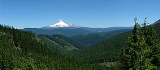
Mount Hood National Forest
Encyclopedia
Portland, Oregon
Portland is a city located in the Pacific Northwest, near the confluence of the Willamette and Columbia rivers in the U.S. state of Oregon. As of the 2010 Census, it had a population of 583,776, making it the 29th most populous city in the United States...
, and the northern Willamette River
Willamette River
The Willamette River is a major tributary of the Columbia River, accounting for 12 to 15 percent of the Columbia's flow. The Willamette's main stem is long, lying entirely in northwestern Oregon in the United States...
valley. The Forest extends south from the Columbia River Gorge
Columbia River Gorge
The Columbia River Gorge is a canyon of the Columbia River in the Pacific Northwest of the United States. Up to deep, the canyon stretches for over as the river winds westward through the Cascade Range forming the boundary between the State of Washington to the north and Oregon to the south...
across more than 60 miles (97 km) of forest
Forest
A forest, also referred to as a wood or the woods, is an area with a high density of trees. As with cities, depending where you are in the world, what is considered a forest may vary significantly in size and have various classification according to how and what of the forest is composed...
ed mountain
Mountain
Image:Himalaya_annotated.jpg|thumb|right|The Himalayan mountain range with Mount Everestrect 58 14 160 49 Chomo Lonzorect 200 28 335 52 Makalurect 378 24 566 45 Mount Everestrect 188 581 920 656 Tibetan Plateaurect 250 406 340 427 Rong River...
s, lake
Lake
A lake is a body of relatively still fresh or salt water of considerable size, localized in a basin, that is surrounded by land. Lakes are inland and not part of the ocean and therefore are distinct from lagoons, and are larger and deeper than ponds. Lakes can be contrasted with rivers or streams,...
s and stream
Stream
A stream is a body of water with a current, confined within a bed and stream banks. Depending on its locale or certain characteristics, a stream may be referred to as a branch, brook, beck, burn, creek, "crick", gill , kill, lick, rill, river, syke, bayou, rivulet, streamage, wash, run or...
s to the Olallie Scenic Area
Olallie Scenic Area
Olallie Scenic Area is a United States Forest Service designated scenic area located in Oregon’s Cascade Mountains. It is between Mount Hood on the north and Mount Jefferson to the south and contains Olallie Lake along with several smaller lakes...
, a high lake basin under the slopes of Mount Jefferson
Mount Jefferson (Oregon)
Mount Jefferson is a stratovolcano in the Cascade Volcanic Arc, part of the Cascade Range, and is the second highest mountain in Oregon. Situated in the far northeastern corner of Linn County on the Jefferson County line, about east of Corvallis, Mount Jefferson is in a rugged wilderness and is...
. The Forest encompasses some 1067043 acres (4,318.17 km²). Forest headquarters are located in Sandy, Oregon
Sandy, Oregon
Sandy is a city located in Clackamas County, Oregon, United States, and named after the nearby Sandy River. As of the 2000 census, the city had a total population of 5,385, however the 2006 estimate shows 7,070 people....
. A 1993 Forest Service study estimated that the extent of old growth in the Forest was 345300 acres (139,738.1 ha). The Forest is divided into four separate districts - Barlow (with offices in Dufur
Dufur, Oregon
Dufur is a city in Wasco County, Oregon, United States. The population was 588 at the 2000 census. It is a farming community, with wheat being an important crop, along with tree fruit and grapes....
), Clackamas River (Estacada
Estacada, Oregon
Estacada is a city in Clackamas County, Oregon, United States, about 30 miles southeast of Portland. The population was 2,695 at the 2010 census. -History:The Estacada post office opened in February 1904 and the city was incorporated in May 1905...
), Hood River (Mount Hood-Parkdale), and Zigzag (Zigzag
Zigzag, Oregon
Zigzag is an unincorporated community in Clackamas County, Oregon, United States. It is located within the Mount Hood Corridor, between Rhododendron and Welches on U.S. Route 26...
).
In descending order of land area the National Forest is located in parts of Clackamas
Clackamas County, Oregon
Clackamas County is a county located in the U.S. state of Oregon. The county was named after the Native Americans living in the area, the Clackamas Indians, who were part of the Chinookan people. As of 2010, the population was 375,992...
, Hood River
Hood River County, Oregon
-Demographics:As of the census of 2000, there were 20,411 people, 7,248 households, and 5,175 families residing in the county. The population density was 39 people per square mile . There were 7,818 housing units at an average density of 15 per square mile...
, Wasco
Wasco County, Oregon
Wasco County is a county located in the U.S. state of Oregon. The county is named for a local tribe of Native Americans, the Wasco, a Chinook tribe who lived on the south side of the Columbia River. In 2010, its population was 25,213...
, Multnomah
Multnomah County, Oregon
Multnomah County is one of 36 counties in the U.S. state of Oregon. Though smallest in area, it is the most populous as its county seat, Portland, is the state's largest city...
, Marion
Marion County, Oregon
Marion County is a county located in the U.S. state of Oregon. It was originally named the Champooick District, after Champoeg, a meeting place on the Willamette River. On September 3, 1849, the territorial legislature renamed it in honor of Francis Marion, a Continental Army general of the...
, and Jefferson
Jefferson County, Oregon
Jefferson County is a county located in the U.S. state of Oregon. In 2010, its population was 21,720. It is named after Mount Jefferson. The seat of the county is Madras.-History:...
counties.
History
Mount Hood National Forest was first established as the Bull Run Forest Reserve in 1892. It was merged with part of Cascade National ForestCascade National Forest
Cascade National Forest was established by the U.S. Forest Service in Oregon on March 2, 1907 with when its name was shortened from Cascade Range National Forest and land was added. On July 1, 1933 the entire forest was combined with Santiam National Forest to establish Willamette National...
on July 1, 1908 and named Oregon National Forest
Oregon National Forest
Oregon National Forest was established by the U.S. Forest Service in Oregon on July 1, 1908 with from part of Cascade National Forest and all of Bull Run National Forest. On January 21, 1924 the forest was renamed Mount Hood National Forest. -External links:...
. The name was changed again to Mount Hood National Forest in 1924.
In 2010, Mount Hood National Forest was honored with its own quarter under the America the Beautiful Quarters program.
Recreation
The Mount Hood National Forest is one of the most-visited National Forests in the United States, with over four million visitors annually. Less than five percent of the visitors camp in the forest. The forest contains 170 developed recreation sites, including:- Timberline Lodge, built in 1937 high on Mount HoodMount HoodMount Hood, called Wy'east by the Multnomah tribe, is a stratovolcano in the Cascade Volcanic Arc of northern Oregon. It was formed by a subduction zone and rests in the Pacific Northwest region of the United States...
- Lost LakeLost Lake (Oregon)Oregon has at least 19 lakes named Lost Lake:...
- Burnt LakeBurnt LakeBurnt Lake is a lake in the Mount Hood National Forest in Oregon, USA. It is in the Sandy River watershed....
- Trillium LakeTrillium LakeTrillium Lake is a lake situated south-southwest of Mount Hood in the U.S. state of Oregon. It is formed by a dam at the headwaters of Mud Creek, tributary to the Salmon River. It was created by the state Department of Fish and Wildlife in 1960....
- Timothy LakeTimothy LakeTimothy Lake is a lake about southeast of Portland, Oregon, United States. It is in close proximity to Clear Lake and an impoundment of the Oak Grove Fork Clackamas River. The compacted-earth dam was built on Timothy Meadows in 1956 to regulate flow to Lake Harriet and the power plant was...
- Rock Creek Reservoir
- The Old Oregon TrailOregon TrailThe Oregon Trail is a historic east-west wagon route that connected the Missouri River to valleys in Oregon and locations in between.After 1840 steam-powered riverboats and steamboats traversing up and down the Ohio, Mississippi and Missouri rivers sped settlement and development in the flat...
, including Barlow RoadBarlow RoadThe Barlow Road is a historic road in what is now the U.S. state of Oregon. It was built in 1846 by Sam Barlow and Philip Foster, with authorization of the Provisional Legislature of Oregon, and served as the last overland segment of the Oregon Trail...
Other common recreational activities in the Mount Hood National Forest include fishing
Fishing
Fishing is the activity of trying to catch wild fish. Fish are normally caught in the wild. Techniques for catching fish include hand gathering, spearing, netting, angling and trapping....
, boating
Boating
Boating is the leisurely activity of travelling by boat, or the recreational use of a boat whether powerboats, sailboats, or man-powered vessels , focused on the travel itself, as well as sports activities, such as fishing or water skiing...
, hiking
Hiking
Hiking is an outdoor activity which consists of walking in natural environments, often in mountainous or other scenic terrain. People often hike on hiking trails. It is such a popular activity that there are numerous hiking organizations worldwide. The health benefits of different types of hiking...
, hunting
Hunting
Hunting is the practice of pursuing any living thing, usually wildlife, for food, recreation, or trade. In present-day use, the term refers to lawful hunting, as distinguished from poaching, which is the killing, trapping or capture of the hunted species contrary to applicable law...
, rafting
Rafting
Rafting or white water rafting is a challenging recreational outdoor activity using an inflatable raft to navigate a river or other bodies of water. This is usually done on white water or different degrees of rough water, in order to thrill and excite the raft passengers. The development of this...
, horseback riding, skiing
Skiing
Skiing is a recreational activity using skis as equipment for traveling over snow. Skis are used in conjunction with boots that connect to the ski with use of a binding....
, mountain biking
Mountain biking
Mountain biking is a sport which consists of riding bicycles off-road, often over rough terrain, using specially adapted mountain bikes. Mountain bikes share similarities with other bikes, but incorporate features designed to enhance durability and performance in rough terrain.Mountain biking can...
, berry
Berry
The botanical definition of a berry is a fleshy fruit produced from a single ovary. Grapes are an example. The berry is the most common type of fleshy fruit in which the entire ovary wall ripens into an edible pericarp. They may have one or more carpels with a thin covering and fleshy interiors....
-picking, and mushroom
Mushroom
A mushroom is the fleshy, spore-bearing fruiting body of a fungus, typically produced above ground on soil or on its food source. The standard for the name "mushroom" is the cultivated white button mushroom, Agaricus bisporus; hence the word "mushroom" is most often applied to those fungi that...
collecting. A portion of the Pacific Crest Trail
Pacific Crest Trail
The Pacific Crest Trail is a long-distance mountain hiking and equestrian trail on the Western Seaboard of the United States. The southern terminus is at the California border with Mexico...
passes through the National Forest on the flanks of the mountain. Mount Hood is a popular destination for mountain climbers, making it the second most climbed mountain in the world.
Several nonprofits lead free hikes into the National Forest to build support for further protection from logging and off-road vehicle
Off-road vehicle
An off-road vehicle is considered to be any type of vehicle which is capable of driving on and off paved or gravel surface. It is generally characterized by having large tires with deep, open treads, a flexible suspension, or even caterpillar tracks...
use, including Bark and Oregon Wild.
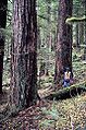
Wilderness
There are more than 295917 acres (1,198 km²) of designated wilderness on the National Forest.- Mount Hood WildernessMount Hood WildernessThe Mount Hood Wilderness is a protected wilderness area inside the Mount Hood National Forest which is located in the U.S. state of Oregon. The area, covering , includes the peak of Mount Hood and its upper slopes, and ranges from temperate rain forests at the lower elevations, to glaciers and...
at 67320 acres (272 km²) includes the peak and upper slopes of Mount Hood. - Badger Creek WildernessBadger Creek WildernessThe Badger Creek Wilderness is a wilderness area located east of Mount Hood in the northwestern Cascades of Oregon, United States. It is one of six designated wilderness areas in the Mount Hood National Forest; the others being Mark O. Hatfield, Salmon-Huckleberry, Mount Hood, Mount Jefferson,...
at approximately 28140 acres (114 km²) - Salmon–Huckleberry Wilderness at 61340 acres (248 km²)
- Mark O. Hatfield WildernessMark O. Hatfield WildernessThe Mark O. Hatfield Wilderness is a wilderness area located on the northern side of Mount Hood in the northwestern Cascades of the U.S. state of Oregon, near the Columbia River Gorge and within Mount Hood National Forest...
at approximately 64960 acres (263 km²) - Bull of the Woods WildernessBull of the Woods WildernessThe Bull of the Woods Wilderness is a wilderness area located in the Mount Hood National Forest in the northwestern Cascades of Oregon, United States. It was created in 1984 and consists of including prime low-elevation old growth forest, about a dozen lakes of at least and many large creeks and...
at 37607 acres (152 km²) - Roaring River WildernessRoaring River WildernessRoaring River Wilderness is a wilderness area in the Mount Hood National Forest in Clackamas County, Oregon, United States. Southwest of Mount Hood, Oregon's tallest mountain, the area was created in 2009...
at 36550 acres (148 km²) - Mount Jefferson WildernessMount Jefferson WildernessThe Mount Jefferson Wilderness is a wilderness area located on and around Mount Jefferson in the central Cascade Range of Oregon in the United States. It is situated where the Willamette, Deschutes, and Mount Hood National Forests meet...
at 111177 acres (450 km²), though only part of the wilderness is located in the Mount Hood National Forest
The Olallie Scenic Area
Olallie Scenic Area
Olallie Scenic Area is a United States Forest Service designated scenic area located in Oregon’s Cascade Mountains. It is between Mount Hood on the north and Mount Jefferson to the south and contains Olallie Lake along with several smaller lakes...
is a lightly roaded lake basin that also offers a primitive recreational experience.
External links
- Mount Hood National Forest - US Forest Service
- Mount Hood National Forest - Wildernet.com
- Hiking Mount Hood National Forest - GORP