
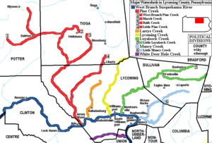
White Deer Hole Creek
Encyclopedia
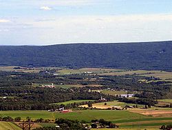
White Deer Hole Creek is a 20.5 miles (33 km) tributary
of the West Branch Susquehanna River
in Clinton
, Lycoming
and Union
counties in the U.S. state of Pennsylvania
. A part of the Chesapeake Bay
drainage basin, the White Deer Hole Creek watershed
drains parts of ten townships
. The creek flows east in a valley of the Ridge-and-valley Appalachians
, through sandstone, limestone, and shale from the Ordovician
, Silurian
, and Devonian
periods.
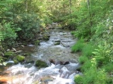
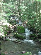
As of 2006, the creek and its 67.2 square miles (174 km²) watershed are relatively undeveloped, with 28.4 percent of the watershed given to agriculture and 71.6 percent covered by forest, including part of Tiadaghton State Forest
. The western part of White Deer Hole Creek has very high water quality and is the only major creek section in Lycoming County classified as "Class A Wild Trout Waters", defined by the Pennsylvania Fish and Boat Commission
as "streams which support a population of naturally produced trout of sufficient size and abundance to support a long-term and rewarding sport fishery." The rest of the creek and its major tributary (Spring Creek) are kept stocked
. There are opportunities in the watershed for canoeing
, hunting
, and camping
, and trail
s for hiking
and horseback riding
.
Historically, two paths of the native indigenous peoples ran along parts of White Deer Hole Creek. Settlers arrived by 1770, but fled in 1778 during the American Revolutionary War
. They returned and the creek served as the southern boundary of Lycoming County when it was formed on April 13, 1795. A logging railroad ran along the creek from 1901 to 1904 for timber clearcutting
, and small-scale lumbering continues. During World War II
a Trinitrotoluene (TNT) plant, which became a federal prison in 1952, was built in the watershed. Most development is in the eastern end of the valley, with two unincorporated
villages, a hamlet, and most of the farms (many Amish
).
have been suggested for White Deer Hole Creek's unusual name. According to Donehoo, it is a translation of the Lenape
(or Delaware) Woap-achtu-woalhen (literally "white-deer digs a hole"), meaning "where the white deer digs". It is Opauchtooalin on the earliest map showing the creek (1755), while a 1759 map has both Opaghtanoten and its translation, "White Flint Creek". These are seen as corruptions of Woap-achtu-woalhen, and by 1770 (when the first settlers arrived) a map has "White Deer hole" (sic).
In 1870, 88-year-old John Farley gave a second explanation of the name. His family had settled on the banks of White Deer Hole Creek in 1787, and John's father John built a mill on the creek by 1789. The creek was named because "a white deer is said to have been killed at an early day in a low hole or pond of water that once existed where my father built his mill". The hole was "a large circular basin of low ground of some ten acres [(four ha)] in extent....after my father's mill and dam were built the water of the dam overflowed and covered the most of the hollow basin of ground." The mill was just west of the mouth at the unincorporated village of Allenwood (then called Uniontown), now in Gregg Township in Union County.
The name "White Deer Hole Creek" is unique in the USGS
Geographic Names Information System
and on its maps of the United States. Although the whole creek is now referred to by this name, in 1870 the name applied only to the section from the confluence with Spring Creek east to its mouth, while the main branch west of Spring Creek was called "South Creek". Meginness used this name in 1892 and it appeared on a 1915 state map of Union County (but not the 1916 Lycoming County map). In 2009 the name "South Creek" has disappeared, but there is still a "South Creek Road" on the right bank of the creek in Gregg Township from near the mouth of Spring Creek west to the county line.
According to Meginness, the 17 miles (27.4 km) long and 8 miles (12.9 km) wide White Deer Hole Creek valley was just called "White Deer valley" by many in 1892, and this is still common. Confusion about the names arises since White Deer Creek
is the next creek south of White Deer Hole Creek (they are on opposite sides of South White Deer Ridge). The Lenape name for White Deer Creek was Woap'-achtu-hanne (translated as "white-deer stream").
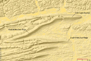
Spring Creek is the only named tributary of White Deer Hole Creek. Five unnamed tributaries flow through named features of South White Deer Ridge. Going upstream in order they are: Beartrap Hollow, First Gap, Second Gap, Third Gap, and Fourth Gap.
 Lycoming County is about 130 miles (209.2 km) northwest of Philadelphia and 165 miles (265.5 km) east-northeast of Pittsburgh
. The source of White Deer Hole Creek is in Crawford Township, just over the Clinton County line. Both it and the western half of the creek are within Tiadaghton State Forest. The creek flows east and soon crosses a natural gas pipeline
and the Lycoming County line into Limestone Township
.
It soon flows into Washington Township
, which has more of White Deer Hole Creek than any other township. It receives unnamed tributaries in the Fourth, Third, Second, and First Gaps of South White Deer Ridge on the south or right bank. The creek leaves Tiadaghton State Forest after the Third Gap (the forest itself continues along the ridge to the river), and stops being "Class A Wild Trout Waters" between the Second and First Gaps. It receives the unnamed tributary in Beartrap Hollow 10.8 miles (17.4 km) west of its mouth, then passes south of the unincorporated village of Elimsport.
White Deer Hole Creek then flows east into Gregg Township in Union County, receiving its major tributary, Spring Creek, on the left bank 3.6 miles (5.8 km) west of its mouth. Spring Creek rises north of Elimsport in Washington Township and flows east-southeast, passing through Pennsylvania State Game Lands
No. 252 and just south of the Federal Correctional Institute, Allenwood
.
The creek next flows just south of the hamlet of Spring Garden, then south of the village of Allenwood, where it has its confluence
with the West Branch Susquehanna River. The direct distance between the source and mouth is only 16 miles (25.7 km). U.S. Route 15
and the Union County Industrial Railroad
run north-south here along the river and cross the creek just before its mouth; however, this track is not in service as of 2009. Pennsylvania Route 44
runs east-west roughly parallel to the creek between Elimsport and Allenwood. Township roads run along the eastern two-thirds of the creek, and smaller, more primitive roads follow it to its source.
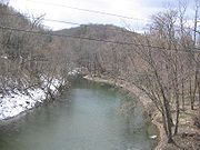
 From the mouth of White Deer Hole Creek it is 17.7 miles (28.5 km) along the West Branch Susquehanna River to its confluence with the Susquehanna River
at Northumberland
. The elevation at the source is 2180 feet (664.5 m), while the mouth is at an elevation of 445 feet (135.6 m). The difference in elevation, 1735 feet (528.8 m), divided by the length of the creek of 20.5 miles (33 km) gives the average drop in elevation per unit length of creek or relief ratio
of 84.6 feet/mile (16.0 m/km). The meander ratio
is 1.14, so the creek's path is not entirely straight in its bed. The meandering increases near the mouth.
For its entire length, White Deer Hole Creek runs along the north side of South White Deer Ridge, an east-west ridge of the Appalachian Mountains
. North White Deer Ridge and Bald Eagle Mountain
form the northern edge of the creek valley. There are 24 unnamed tributaries on the south side of the creek, all flowing down the side of South White Deer Ridge, while there are only 11 tributaries on the north side, including Spring Creek.
White Deer Creek, the next major creek to the south, flows along the other side of South White Deer Ridge in Union County and is just 1.9 miles (3.1 km) away (as measured along the West Branch Susquehanna River). The next major creek to the north is Muncy Creek
, 10.2 miles (16.4 km) away along the river, but on the opposite bank. The next creek to the north on the same bank is Black Hole Creek, on the south side of Bald Eagle Mountain. It has a small watershed of 21.1 square miles (54.6 km²) and enters the river 4 miles (6.4 km) away at the borough of Montgomery
.
 White Deer Hole Creek is in a sandstone, limestone, and shale mountain region, entirely in the Ridge-and-valley Appalachians. South and North White Deer Ridge and Bald Eagle Mountain are composed of sedimentary Ordovician rock, while the valley rock is Silurian, with a small Devonian region closer to the river, in the north. The watershed has no deposits of coal, nor natural gas or oil fields. The creek is in a narrow mountain valley with steep slopes in its upper reaches. In its middle and lower reaches it has steep mountain slopes to the south, and a wide valley with rolling hills and gentle slopes to the north. The channel
pattern is transitional, with a trellised drainage pattern.
From 1961 to 1995, the United States Geological Survey
(USGS) operated one stream gauge
on White Deer Hole Creek at the Gap Road bridge (upstream of Elimsport), for the uppermost 18.2 square miles (47.1 km²) of the watershed. The highest yearly peak discharge
measured at this site was 4200 cubic feet (118.9 m³) per second and the highest yearly peak gauge height was 11.83 feet (3.6 m), both on June 22, 1972, during Hurricane Agnes
. The lowest yearly peak discharge in this time period was 135 cubic feet (3.8 m³) per second and the lowest yearly peak gauge height was 4.29 feet (1.3 m), both on November 26, 1986. The USGS also measured discharge at Allenwood, very near the creek's mouth, as part of water quality measurements on seven occasions between 1970 and 1975. The average discharge was 70.4 cubic feet (2 m³) per second, and ranged from a high of 111 cubic feet (3.1 m³) per second to a low of 33 cubic foot (0.934455951 m³) per second. There are no other known stream gauges on the creek.
 The White Deer Hole Creek watershed consists of 0.08 percent of the area of Clinton County, 4.40 percent of the area of Lycoming County, and 3.67 percent of the area of Union County. Neighboring watersheds are the West Branch Susquehanna River and its minor tributaries (north and east), White Deer Creek (south), and Fishing Creek
(west).
In 2000, the White Deer Hole Creek watershed population was 2,672. In the 1970s, Amish began moving to the Elimsport area from Lancaster County
. In 1995 there were over 200 Amish in more than twenty families. In comparison, Washington Township's population was 1,613 in 2000. Elimsport has Amish harness, machine repair, and food shops, and a new one-room school
was built nearby in 1997.
The watershed area is 67 square miles (173.5 km²), with 48 square miles (124.3 km²) of forest and 19 square miles (49.2 km²) for agriculture. By area, 1.1 percent of the watershed lies in Clinton County (in Crawford and Greene
Townships), 81.6 percent lies in Lycoming County (in Brady
, Clinton
, Limestone, and Washington Townships), and 17.3 percent lies in Union County (in Gregg, Lewis
, West Buffalo, and White Deer Townships).
Spring Creek is the major tributary, draining an area of 21.1 square miles (54.6 km²) or 31 percent of the total White Deer Hole Creek watershed. No other tributaries are named and only the area of the tributary in Beartrap Hollow is known, with 0.42 square miles (1.1 km²) or 0.63 percent of the total.
was and is another potential source of pollution. Gregg Township had no wastewater treatment plant
until an 800,000-gallon/day (304 m³/day) plant was built along the river just north of the creek for the federal prison (90 percent) and village of Allenwood (10 percent). The drainage basin has been designated by Pennsylvania Department of Environmental Protection as "a high quality watershed" since 2001.
The mean annual precipitation
for White Deer Hole Creek is 40 to 42 inches (1,016 to 1,067 mm). Pennsylvania receives the most acid rain
of any state in the United States. Because the creek is in a sandstone, limestone, and shale mountain region, it has a relatively low capacity to neutralize added acid. This makes it especially vulnerable to acid rain, which poses a threat to the long term health of the plants and animals in the creek. The total alkalinity
of the "Class A Wild Trout Waters" is 2 for the 4.7 miles (7.6 km) of White Deer Hole Creek so classified, and 13 for the 3 miles (4.8 km) unnamed tributary in the Fourth Gap.
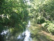
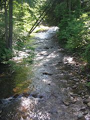
 Edward Gertler writes in Keystone Canoeing that White Deer Hole Creek "offers a good springtime beginner cruise through a pretty, agricultural valley" with "many satisfying views" and "good current and many easy riffles". Canoeing and kayaking are possible in spring and after hard rain, with 10.6 miles (17.1 km) of Class 1 whitewater
on the International Scale of River Difficulty
from Back Road bridge east to U.S. Route 15 (the mouth). One can start further upstream at the Gap Road bridge, for 2 miles (3.2 km) of Class 2 whitewater, but strainers are more of a problem here.
White Deer Hole Creek is designated by the Pennsylvania Fish and Boat Commission as a "Class A Wild Trout Waters" stream, from the source downstream to the Township Road 384 (Gap Road) bridge. The unnamed tributary in Fourth Gap is also "Class A Wild Trout Waters". The creek downstream from the bridge, as well as Spring Creek, have been designated as approved trout waters by the Pennsylvania Fish and Boat Commission and are stocked
with trout and may be fished during trout season. Other fish found in the creek and river include carp
, catfish
, pickerel
, and pike.
Hunting, trapping, and fishing are possible with proper licenses in Tiadaghton State Forest and the 3018 acres (1,221.3 ha) in State Game Lands No. 252. In 2002, a Pennsylvania Department of Conservation and Natural Resources
report on "State Forest Waters with Special Protection" rated White Deer Hole Creek from its source to Spring Creek as a "High Quality-Cold Water Fishery". In addition to these public lands, there are private hunting and fishing clubs and cabins along White Deer Hole Creek and its tributaries. Popular game species include American Black Bear
, White-tailed Deer
, Ruffed Grouse
, and Wild Turkey
.
Part of the 261 miles (420 km) Pennsylvania Mid State Trail
, marked with orange blazes
to indicate it is solely for hiking, runs along a section of White Deer Hole Creek from west of the Fourth Gap to beyond the source. There are other hiking trails in the watershed, and the Third Gap, Metzger, Mud Hole, Pennsylvania Mid State, Sawalt, and Mountain Gap trails are part of the 120 miles (193.1 km) Central Mountains Shared Use Trails System
, marked with red blazes, in Tiadaghton and Bald Eagle State Forest
s in Union, Lycoming, and Clinton Counties.
Roads and trails in the state forest are also open for horseback riding and mountain biking. Some trails are dedicated to cross-country skiing and snowmobiling in winter. The state forest is open for primitive camping, although certain areas require a permit. Small campfires are allowed, except from March to mid-May and October through November, or by order of the district forester, when self-contained stoves are allowed.

s, an Iroquoian
speaking people. Their name meant "people of the muddy river" in the Algonquian
, but their name for themselves is unknown. Decimated by diseases and warfare, they had largely died out, moved away, or been assimilated
into other tribes by the early 18th century. The lands of the West Branch Susquehanna River valley were then chiefly occupied by the Munsee
phratry
of the Lenape
(or Delaware), and were under the nominal control of the Five (later Six) Nations of the Iroquois
. Two important paths of these native indigenous peoples ran along parts of White Deer Hole Creek.
The Great Island Path
was a major trail that ran north along the Susquehanna River from the Saponi village of Shamokin
at modern Sunbury
, fording the river there and following the west bank of the West Branch Susquehanna River north until White Deer Hole valley. The path turned west at Allenwood and followed White Deer Hole Creek until about the present location of Elimsport. There it headed northwest, crossed North White Deer Ridge and passed west through the Nippenose
valley, then turned north and crossed Bald Eagle Mountain via McElhattan Creek and ran along the south bank of the river to the Great Island (near the present day city of Lock Haven
). The stretch from the mouth of the creek to the Nippenose valley is approximately followed by Route 44. From the Great Island, the Great Shamokin Path
continued further west to the modern boroughs of Clearfield
and Kittanning
, the last on the Allegheny River
.
 Culbertson's Path
followed White Deer Hole Creek west from Allenwood, then followed Spring Creek north, crossed Bald Eagle Mountain and followed Mosquito Run to the river at the current borough of Duboistown
. Here it crossed the river to "French Margaret's Town" (western modern day Williamsport
) before joining the major Sheshequin Path
, which led north up Lycoming Creek
to the North Branch of the Susquehanna River, modern New York
, and the Iroquois there. These trails were only wide enough for one person, but settlers in White Deer Hole valley broadened the path to DuBoistown to take grain to Culbertson's mill on Mosquito Run, hence the name. Culbertson's Path was used as a part of the Underground Railroad
until the American Civil War
began in 1861. Escaped slaves would often wade in creeks to hide their scent from pursuing bloodhound
s. In 2009, there is still a "Culbertson's Trail", for hiking over Bald Eagle Mountain from Pennsylvania Route 554
to Duboistown.
The borders of the county have changed considerably since, but the White Deer Hole Creek watershed still approximates the county line in the south. Until 1861, what is now Gregg Township in Union County was a part of Brady Township in Lycoming County. Thus, until the start of the American Civil War
, almost all of White Deer Hole Creek and its watershed were part of Lycoming County.
 Prior to construction, the site of the wastewater treatment plant yielded archeological evidence of habitation by indigenous peoples from the Paleo-Indian, Archaic, and Woodland period
s. The only Native American inhabitant of the valley whose name is known, "Cochnehaw", lived near the mouth of White Deer Hole Creek. White Deer Hole Creek was acquired by the colonial government of Pennsylvania on November 5, 1768, as part of the "New Purchase" in the Treaty of Fort Stanwix
. The first settlers came to the valley in 1769 or 1770, and by 1778 there were 146 landowners on the township tax rolls (though many likely resided elsewhere.)
In the American Revolutionary War, settlements throughout the Susquehanna valley were attacked by Loyalists
and Native Americans allied with the British. After the Wyoming Valley battle and massacre in the summer of 1778 (near what is now Wilkes-Barre
) and smaller local attacks, the "Big Runaway" occurred throughout the West Branch Susquehanna valley. Settlers fled from feared and actual attacks by the British and their allies. Settlers abandoned their homes and fields, drove their livestock south, and towed their possessions on rafts on the river to Sunbury
. Their abandoned property was burnt by the attackers. Some settlers soon returned, only to flee again in the summer of 1779 in the "Little Runaway".
Sullivan's Expedition helped stabilize the area and encouraged resettlement, which continued after the war. However, in 1787 there were only fourteen families in the valley: five on the river banks, five on White Deer Hole Creek between Spring Creek and the river, two on Spring Creek, and two on the creek west of Spring Creek. Six families left the area not long after 1787. The first grist mill was built on the creek in 1789, and four more were built in 1798, 1815, 1817, and 1842.
 Beginning with the first settlers, much of the land along White Deer Hole Creek was slowly cleared of timber. Small sawmills were constructed in the 19th century, and a much larger lumber operation was run by the Vincent Lumber Company from 1901 to 1904. The company built a narrow gauge 42 inches (1,066.8 mm) railroad from Elimsport 5 miles (8 km) west into timber, and a line east to Allenwood and the Reading Railroad there. The lumber railroad, which ended near the Fourth Gap, ran parallel to the creek. It was incorporated on June 24, 1901, (around the time of construction) as the "Allenwood and Western Railroad". The lumbering operation ceased in 1904 when the forests were gone. The railroad was torn up, and its one second-hand Shay locomotive
was moved to the Vincent Lumber Company operation at Denholm in Juniata County
.
From 1900 to 1935, much of what is now Tiadaghton State Forest was purchased by Pennsylvania from lumber companies that had no further use for the clear-cut land. In the 1930s there were seven Civilian Conservation Corps
(CCC) camps to construct roads and trails in the forest. CCC Camp S-125-Pa (Elimsport) was located 15 miles (24.1 km) west of Allenwood along the creek, between the Third and Fourth Gaps.
Small-scale lumbering continues in the watershed, but the forest is certified as well-managed "in an environmentally sensitive manner" and lumber from it qualifies for a "green label". Gertler reports lumber operations along White Deer Hole Creek near Elimsport in the early 1980s. A sawmill owned and operated by Amish is on Route 44 in Elimsport. It burned down on May 10, 2006, causing $500,000 in damages, but was expected to be back in operation in a month; it has since reopened. Despite this small-scale lumbering, as of 2009 the forests have grown back and are mixed oak
, with blueberry
and mountain laurel
bushes. White Deer Hole Creek and its tributaries also have stands of hemlock
and thickets of rhododendron
along them.
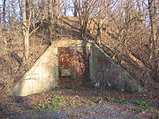
Depot to make TNT on 8500 acres (3,439.8 ha), partially in the White Deer Hole Creek watershed. In the spring of 1942, residents were evicted by eminent domain
from 163 farms and 47 other properties in Gregg Township in Union County and Brady, Clinton, and Washington Townships in Lycoming County. The village of Alvira in Gregg Township disappeared. Alvira was founded in 1825 as "Wisetown" and had 100 inhabitants by 1900. Although the inhabitants were told they could return after the war, almost all the buildings seized were razed. Only some cemeteries and the nearby "Stone Church" remain. Construction of the plant involved some 10,000 people, and it took 3,500 to 4,500 employees to run the plant with its more than 200 buildings and 149 storage bunkers for TNT and high explosives, as well as storage racks of bombs. However, the need for TNT was lower than originally estimated and the project was nearly abandoned. By 1945, the only workers left at the depot were guards.
 The depot closed after the war and the land was used by the United States Army for testing. In 1950, the Federal Bureau of Prisons
was given 4000 acres (1,618.7 ha) of the plant site, and began housing prisoners from the Lewisburg Federal Penitentiary
there in 1952. In 1957 the "Allenwood Prison Camp" was built, which became the "Federal Correctional Institute, Allenwood". This was greatly expanded in the early 1990s to become "the largest federal prison facility" in the United States. North of the White Deer Hole Creek watershed, some of the land was sold to make the "White Deer Golf Course" in Clinton Township, and in 1973, 125 acres (50.6 ha) of prison land in Brady Township were leased to Lycoming County for its landfill (which serves five counties).
The remaining 3018 acres (1,221.3 ha) were given to Pennsylvania and became State Game Lands 252. Many of the 149 concrete bunkers remain, but it is "a diverse mix of mature forest, impoundments, and brushy thickets, as well as a local hotspot for a variety of birds during migration". The watershed is a haven for wildlife. Common animals in the game lands include Painted
and Common Snapping Turtles, Muskrat
s, Frog
s, Eastern Cottontail
s, Red Fox
es, and White-tailed Deer
, while birds include Golden-winged
, Hooded
, and Blue-winged Warbler
s, Red-shouldered Hawk
s, Wood Duck
s, Tundra Swans
, Pied-billed Grebe
s, American Bittern
s, Heron
s, and Belted Kingfisher
s. The first Barn Owl
s to be banded
in Lycoming County were in a barn near Elimsport in 2006. Gray Squirrels
, Groundhog
s, Raccoon
s, Crow
s, Red-tailed Hawk
s, Downy Woodpecker
s, Cardinals
, Blue Jay
s, American Robin
s, Nuthatch
es, Titmice
, and Sparrow
s are also found in the White Deer Hole Creek watershed.
Tributary
A tributary or affluent is a stream or river that flows into a main stem river or a lake. A tributary does not flow directly into a sea or ocean...
of the West Branch Susquehanna River
West Branch Susquehanna River
The West Branch Susquehanna River is one of the two principal branches, along with the North Branch, of the Susquehanna River in the northeastern United States. The North Branch, which rises in upstate New York, is generally regarded as the extension of the main branch, with the shorter West Branch...
in Clinton
Clinton County, Pennsylvania
As of the census of 2000, there were 37,914 people, 14,773 households, and 9,927 families residing in the county. The population density was 43 people per square mile . There were 18,166 housing units at an average density of 20 per square mile...
, Lycoming
Lycoming County, Pennsylvania
-Appalachian Mountains and Allegheny Plateau:Lycoming County is divided between the Appalachian Mountains in the south, the dissected Allegheny Plateau in the north and east, and the valley of the West Branch Susquehanna River between these.-West Branch Susquehanna River:The West Branch of the...
and Union
Union County, Pennsylvania
-Demographics:As of the census of 2000, there were 41,624 people, 13,178 households, and 9,211 families residing in the county. The population density was 131 people per square mile . There were 14,684 housing units at an average density of 46 per square mile...
counties in the U.S. state of Pennsylvania
Pennsylvania
The Commonwealth of Pennsylvania is a U.S. state that is located in the Northeastern and Mid-Atlantic regions of the United States. The state borders Delaware and Maryland to the south, West Virginia to the southwest, Ohio to the west, New York and Ontario, Canada, to the north, and New Jersey to...
. A part of the Chesapeake Bay
Chesapeake Bay
The Chesapeake Bay is the largest estuary in the United States. It lies off the Atlantic Ocean, surrounded by Maryland and Virginia. The Chesapeake Bay's drainage basin covers in the District of Columbia and parts of six states: New York, Pennsylvania, Delaware, Maryland, Virginia, and West...
drainage basin, the White Deer Hole Creek watershed
Drainage basin
A drainage basin is an extent or an area of land where surface water from rain and melting snow or ice converges to a single point, usually the exit of the basin, where the waters join another waterbody, such as a river, lake, reservoir, estuary, wetland, sea, or ocean...
drains parts of ten townships
Township (Pennsylvania)
A township in the Commonwealth of Pennsylvania, a state of the United States of America, is one of four types of municipalities in the state . Townships were established based on convenient geographical boundaries and vary in size from six to forty square miles...
. The creek flows east in a valley of the Ridge-and-valley Appalachians
Ridge-and-valley Appalachians
The Ridge-and-Valley Appalachians, also called the Ridge and Valley Province or the Valley and Ridge Appalachians, are a physiographic province of the larger Appalachian division and are also a belt within the Appalachian Mountains extending from southeastern New York through northwestern New...
, through sandstone, limestone, and shale from the Ordovician
Ordovician
The Ordovician is a geologic period and system, the second of six of the Paleozoic Era, and covers the time between 488.3±1.7 to 443.7±1.5 million years ago . It follows the Cambrian Period and is followed by the Silurian Period...
, Silurian
Silurian
The Silurian is a geologic period and system that extends from the end of the Ordovician Period, about 443.7 ± 1.5 Mya , to the beginning of the Devonian Period, about 416.0 ± 2.8 Mya . As with other geologic periods, the rock beds that define the period's start and end are well identified, but the...
, and Devonian
Devonian
The Devonian is a geologic period and system of the Paleozoic Era spanning from the end of the Silurian Period, about 416.0 ± 2.8 Mya , to the beginning of the Carboniferous Period, about 359.2 ± 2.5 Mya...
periods.
As of 2006, the creek and its 67.2 square miles (174 km²) watershed are relatively undeveloped, with 28.4 percent of the watershed given to agriculture and 71.6 percent covered by forest, including part of Tiadaghton State Forest
Tiadaghton State Forest
Tiadaghton State Forest is a Pennsylvania State Forest in Pennsylvania Bureau of Forestry District #12. The forest is chiefly in western and southern Lycoming County, with small portions in Clinton, Potter, Tioga, and Union counties....
. The western part of White Deer Hole Creek has very high water quality and is the only major creek section in Lycoming County classified as "Class A Wild Trout Waters", defined by the Pennsylvania Fish and Boat Commission
Pennsylvania Fish and Boat Commission
The Pennsylvania Fish and Boat Commission is the state agency responsible for the regulation of all fishing and boating in the Commonwealth of Pennsylvania...
as "streams which support a population of naturally produced trout of sufficient size and abundance to support a long-term and rewarding sport fishery." The rest of the creek and its major tributary (Spring Creek) are kept stocked
Fish stocking
Fish stocking is the practice of raising fish in a hatchery and releasing them into a river, lake, or the ocean to supplement existing populations, or to create a population where none exists...
. There are opportunities in the watershed for canoeing
Canoeing
Canoeing is an outdoor activity that involves a special kind of canoe.Open canoes may be 'poled' , sailed, 'lined and tracked' or even 'gunnel-bobbed'....
, hunting
Hunting
Hunting is the practice of pursuing any living thing, usually wildlife, for food, recreation, or trade. In present-day use, the term refers to lawful hunting, as distinguished from poaching, which is the killing, trapping or capture of the hunted species contrary to applicable law...
, and camping
Camping
Camping is an outdoor recreational activity. The participants leave urban areas, their home region, or civilization and enjoy nature while spending one or several nights outdoors, usually at a campsite. Camping may involve the use of a tent, caravan, motorhome, cabin, a primitive structure, or no...
, and trail
Trail
A trail is a path with a rough beaten or dirt/stone surface used for travel. Trails may be for use only by walkers and in some places are the main access route to remote settlements...
s for hiking
Hiking
Hiking is an outdoor activity which consists of walking in natural environments, often in mountainous or other scenic terrain. People often hike on hiking trails. It is such a popular activity that there are numerous hiking organizations worldwide. The health benefits of different types of hiking...
and horseback riding
Equestrianism
Equestrianism more often known as riding, horseback riding or horse riding refers to the skill of riding, driving, or vaulting with horses...
.
Historically, two paths of the native indigenous peoples ran along parts of White Deer Hole Creek. Settlers arrived by 1770, but fled in 1778 during the American Revolutionary War
American Revolution
The American Revolution was the political upheaval during the last half of the 18th century in which thirteen colonies in North America joined together to break free from the British Empire, combining to become the United States of America...
. They returned and the creek served as the southern boundary of Lycoming County when it was formed on April 13, 1795. A logging railroad ran along the creek from 1901 to 1904 for timber clearcutting
Clearcutting
Clearcutting, or clearfelling, is a controversial forestry/logging practice in which most or all trees in an area are uniformly cut down. Clearcutting, along with shelterwood and seed tree harvests, is used by foresters to create certain types of forest ecosystems and to promote select species that...
, and small-scale lumbering continues. During World War II
World War II
World War II, or the Second World War , was a global conflict lasting from 1939 to 1945, involving most of the world's nations—including all of the great powers—eventually forming two opposing military alliances: the Allies and the Axis...
a Trinitrotoluene (TNT) plant, which became a federal prison in 1952, was built in the watershed. Most development is in the eastern end of the valley, with two unincorporated
Unincorporated area
In law, an unincorporated area is a region of land that is not a part of any municipality.To "incorporate" in this context means to form a municipal corporation, a city, town, or village with its own government. An unincorporated community is usually not subject to or taxed by a municipal government...
villages, a hamlet, and most of the farms (many Amish
Amish
The Amish , sometimes referred to as Amish Mennonites, are a group of Christian church fellowships that form a subgroup of the Mennonite churches...
).
Name
Two etymologiesEtymology
Etymology is the study of the history of words, their origins, and how their form and meaning have changed over time.For languages with a long written history, etymologists make use of texts in these languages and texts about the languages to gather knowledge about how words were used during...
have been suggested for White Deer Hole Creek's unusual name. According to Donehoo, it is a translation of the Lenape
Lenape language
The Delaware languages, also known as the Lenape languages, are Munsee and Unami, two closely related languages of the Eastern Algonquian subgroup of the Algonquian language family...
(or Delaware) Woap-achtu-woalhen (literally "white-deer digs a hole"), meaning "where the white deer digs". It is Opauchtooalin on the earliest map showing the creek (1755), while a 1759 map has both Opaghtanoten and its translation, "White Flint Creek". These are seen as corruptions of Woap-achtu-woalhen, and by 1770 (when the first settlers arrived) a map has "White Deer hole" (sic).
In 1870, 88-year-old John Farley gave a second explanation of the name. His family had settled on the banks of White Deer Hole Creek in 1787, and John's father John built a mill on the creek by 1789. The creek was named because "a white deer is said to have been killed at an early day in a low hole or pond of water that once existed where my father built his mill". The hole was "a large circular basin of low ground of some ten acres [(four ha)] in extent....after my father's mill and dam were built the water of the dam overflowed and covered the most of the hollow basin of ground." The mill was just west of the mouth at the unincorporated village of Allenwood (then called Uniontown), now in Gregg Township in Union County.
The name "White Deer Hole Creek" is unique in the USGS
United States Geological Survey
The United States Geological Survey is a scientific agency of the United States government. The scientists of the USGS study the landscape of the United States, its natural resources, and the natural hazards that threaten it. The organization has four major science disciplines, concerning biology,...
Geographic Names Information System
Geographic Names Information System
The Geographic Names Information System is a database that contains name and locative information about more than two million physical and cultural features located throughout the United States of America and its territories. It is a type of gazetteer...
and on its maps of the United States. Although the whole creek is now referred to by this name, in 1870 the name applied only to the section from the confluence with Spring Creek east to its mouth, while the main branch west of Spring Creek was called "South Creek". Meginness used this name in 1892 and it appeared on a 1915 state map of Union County (but not the 1916 Lycoming County map). In 2009 the name "South Creek" has disappeared, but there is still a "South Creek Road" on the right bank of the creek in Gregg Township from near the mouth of Spring Creek west to the county line.
According to Meginness, the 17 miles (27.4 km) long and 8 miles (12.9 km) wide White Deer Hole Creek valley was just called "White Deer valley" by many in 1892, and this is still common. Confusion about the names arises since White Deer Creek
White Deer Creek
White Deer Creek is a tributary of the West Branch Susquehanna River in central Pennsylvania in the United States.White Deer Creek joins the West Branch Susquehanna River at White Deer.-References:...
is the next creek south of White Deer Hole Creek (they are on opposite sides of South White Deer Ridge). The Lenape name for White Deer Creek was Woap'-achtu-hanne (translated as "white-deer stream").
Spring Creek is the only named tributary of White Deer Hole Creek. Five unnamed tributaries flow through named features of South White Deer Ridge. Going upstream in order they are: Beartrap Hollow, First Gap, Second Gap, Third Gap, and Fourth Gap.
Course
Pittsburgh, Pennsylvania
Pittsburgh is the second-largest city in the US Commonwealth of Pennsylvania and the county seat of Allegheny County. Regionally, it anchors the largest urban area of Appalachia and the Ohio River Valley, and nationally, it is the 22nd-largest urban area in the United States...
. The source of White Deer Hole Creek is in Crawford Township, just over the Clinton County line. Both it and the western half of the creek are within Tiadaghton State Forest. The creek flows east and soon crosses a natural gas pipeline
Pipeline transport
Pipeline transport is the transportation of goods through a pipe. Most commonly, liquids and gases are sent, but pneumatic tubes that transport solid capsules using compressed air are also used....
and the Lycoming County line into Limestone Township
Limestone Township, Lycoming County, Pennsylvania
Limestone Township is a township in Lycoming County, Pennsylvania, in the United States. The population was 2,136 at the 2000 census. It is part of the Williamsport, Pennsylvania Metropolitan Statistical Area.-History:...
.
It soon flows into Washington Township
Washington Township, Lycoming County, Pennsylvania
Washington Township is a township in Lycoming County, Pennsylvania, in the United States. The population was 1,613 at the 2000 census. It is part of the Williamsport, Pennsylvania Metropolitan Statistical Area.-History:...
, which has more of White Deer Hole Creek than any other township. It receives unnamed tributaries in the Fourth, Third, Second, and First Gaps of South White Deer Ridge on the south or right bank. The creek leaves Tiadaghton State Forest after the Third Gap (the forest itself continues along the ridge to the river), and stops being "Class A Wild Trout Waters" between the Second and First Gaps. It receives the unnamed tributary in Beartrap Hollow 10.8 miles (17.4 km) west of its mouth, then passes south of the unincorporated village of Elimsport.
White Deer Hole Creek then flows east into Gregg Township in Union County, receiving its major tributary, Spring Creek, on the left bank 3.6 miles (5.8 km) west of its mouth. Spring Creek rises north of Elimsport in Washington Township and flows east-southeast, passing through Pennsylvania State Game Lands
Pennsylvania State Game Lands
The Pennsylvania State Game Lands are lands managed by the Pennsylvania Game Commission for hunting, trapping, and fishing. These lands, often not usable for farming or development, are donated to the PGC or purchased by the PGC with hunting license monies.The Pennsylvania Game Commission runs a...
No. 252 and just south of the Federal Correctional Institute, Allenwood
Federal Correctional Institute, Allenwood
Allenwood Federal Correctional Complex is a United States Federal Bureau of Prisons facility located on U.S. Route 15 in Gregg Township, Union County, Pennsylvania. The prison, at the foothills of the Allegheny Mountains, is on U.S. Route 15, north of Allenwood, south of Williamsport, and north...
.
The creek next flows just south of the hamlet of Spring Garden, then south of the village of Allenwood, where it has its confluence
Confluence (geography)
In geography, a confluence is the meeting of two or more bodies of water. It usually refers to the point where two streams flow together, merging into a single stream...
with the West Branch Susquehanna River. The direct distance between the source and mouth is only 16 miles (25.7 km). U.S. Route 15
U.S. Route 15
U.S. Route 15 is a -long United States highway, designated along South Carolina, North Carolina, Virginia, Maryland, Pennsylvania, and New York. The route is signed north–south, from U.S. Route 17 Alternate in Walterboro, South Carolina to Interstate 86 and NY 17 in Painted Post, New York.US...
and the Union County Industrial Railroad
Union County Industrial Railroad
The Union County Industrial Railroad is a short line railroad that operates on approximately 12 miles of track in Union County in the U.S. State of Pennsylvania. It is part of the North Shore Railroad System....
run north-south here along the river and cross the creek just before its mouth; however, this track is not in service as of 2009. Pennsylvania Route 44
Pennsylvania Route 44
Pennsylvania Route 44 is a -long state highway in the U.S. state of Pennsylvania. The route is designated from Interstate 80 and Pennsylvania Route 42 in Buckhorn to the New York state line near New York State Route 417 in Ceres Township....
runs east-west roughly parallel to the creek between Elimsport and Allenwood. Township roads run along the eastern two-thirds of the creek, and smaller, more primitive roads follow it to its source.
Susquehanna River
The Susquehanna River is a river located in the northeastern United States. At long, it is the longest river on the American east coast that drains into the Atlantic Ocean, and with its watershed it is the 16th largest river in the United States, and the longest river in the continental United...
at Northumberland
Northumberland, Pennsylvania
Northumberland is a borough in Northumberland County, Pennsylvania, United States. The population was 3,714 at the 2000 census.-History:Northumberland was founded in 1772. The land that became Northumberland was purchased from the Iroquois in the first Treaty of Fort Stanwix in 1768, and the...
. The elevation at the source is 2180 feet (664.5 m), while the mouth is at an elevation of 445 feet (135.6 m). The difference in elevation, 1735 feet (528.8 m), divided by the length of the creek of 20.5 miles (33 km) gives the average drop in elevation per unit length of creek or relief ratio
Relief ratio
The relief ratio is a number calculated to describe the Grade of a river or stream.The calculation is just the difference in elevation between the river's source and the river's confluence or mouth divided by the total length of the river or stream. This gives the average drop in elevation per...
of 84.6 feet/mile (16.0 m/km). The meander ratio
Meander
A meander in general is a bend in a sinuous watercourse. A meander is formed when the moving water in a stream erodes the outer banks and widens its valley. A stream of any volume may assume a meandering course, alternately eroding sediments from the outside of a bend and depositing them on the...
is 1.14, so the creek's path is not entirely straight in its bed. The meandering increases near the mouth.
For its entire length, White Deer Hole Creek runs along the north side of South White Deer Ridge, an east-west ridge of the Appalachian Mountains
Appalachian Mountains
The Appalachian Mountains #Whether the stressed vowel is or ,#Whether the "ch" is pronounced as a fricative or an affricate , and#Whether the final vowel is the monophthong or the diphthong .), often called the Appalachians, are a system of mountains in eastern North America. The Appalachians...
. North White Deer Ridge and Bald Eagle Mountain
Bald Eagle Mountain
Bald Eagle Mountain, once known locally as Muncy Mountain, is a stratigraphic ridge in central Pennsylvania, United States, running east of the Allegheny Front and northwest of Mount Nittany. It lies along the southeast side of Bald Eagle Creek, and south of the West Branch Susquehanna River, and...
form the northern edge of the creek valley. There are 24 unnamed tributaries on the south side of the creek, all flowing down the side of South White Deer Ridge, while there are only 11 tributaries on the north side, including Spring Creek.
White Deer Creek, the next major creek to the south, flows along the other side of South White Deer Ridge in Union County and is just 1.9 miles (3.1 km) away (as measured along the West Branch Susquehanna River). The next major creek to the north is Muncy Creek
Muncy Creek
Muncy Creek is a tributary of the West Branch Susquehanna River in Lycoming and Sullivan counties, Pennsylvania, USA. Little Muncy Creek is its major tributary.-Course:The creek is long. For much of its length, U.S. Route 220 runs parallel to Muncy Creek....
, 10.2 miles (16.4 km) away along the river, but on the opposite bank. The next creek to the north on the same bank is Black Hole Creek, on the south side of Bald Eagle Mountain. It has a small watershed of 21.1 square miles (54.6 km²) and enters the river 4 miles (6.4 km) away at the borough of Montgomery
Montgomery, Pennsylvania
Montgomery is a borough in Lycoming County, Pennsylvania, in the United States. The population was 1,695 at the 2000 census. It is part of the Williamsport, Pennsylvania Metropolitan Statistical Area.-History:...
.
Geology
Stream bed
A stream bed is the channel bottom of a stream, river or creek; the physical confine of the normal water flow. The lateral confines or channel margins, during all but flood stage, are known as the stream banks or river banks. In fact, a flood occurs when a stream overflows its banks and flows onto...
pattern is transitional, with a trellised drainage pattern.
From 1961 to 1995, the United States Geological Survey
United States Geological Survey
The United States Geological Survey is a scientific agency of the United States government. The scientists of the USGS study the landscape of the United States, its natural resources, and the natural hazards that threaten it. The organization has four major science disciplines, concerning biology,...
(USGS) operated one stream gauge
Stream gauge
A stream gauge, stream gage or gauging station is a location used by hydrologists or environmental scientists to monitor and test terrestrial bodies of water. Hydrometric measurements of water surface elevation and/or volumetric discharge are generally taken and observations of biota may also be...
on White Deer Hole Creek at the Gap Road bridge (upstream of Elimsport), for the uppermost 18.2 square miles (47.1 km²) of the watershed. The highest yearly peak discharge
Discharge (hydrology)
In hydrology, discharge is the volume rate of water flow, including any suspended solids , dissolved chemical species and/or biologic material , which is transported through a given cross-sectional area...
measured at this site was 4200 cubic feet (118.9 m³) per second and the highest yearly peak gauge height was 11.83 feet (3.6 m), both on June 22, 1972, during Hurricane Agnes
Hurricane Agnes
Hurricane Agnes was the first tropical storm and first hurricane of the 1972 Atlantic hurricane season. A rare June hurricane, it made landfall on the Florida Panhandle before moving northeastward and ravaging the Mid-Atlantic region as a tropical storm...
. The lowest yearly peak discharge in this time period was 135 cubic feet (3.8 m³) per second and the lowest yearly peak gauge height was 4.29 feet (1.3 m), both on November 26, 1986. The USGS also measured discharge at Allenwood, very near the creek's mouth, as part of water quality measurements on seven occasions between 1970 and 1975. The average discharge was 70.4 cubic feet (2 m³) per second, and ranged from a high of 111 cubic feet (3.1 m³) per second to a low of 33 cubic foot (0.934455951 m³) per second. There are no other known stream gauges on the creek.
Watershed
Fishing Creek (Bald Eagle Creek)
Fishing Creek is a tributary of Bald Eagle Creek in Clinton County, Pennsylvania, in the United States.Fishing Creek passes through a water gap in Bald Eagle Mountain at Mill Hall, and joins Bald Eagle Creek near the borough of Flemington.-References:...
(west).
In 2000, the White Deer Hole Creek watershed population was 2,672. In the 1970s, Amish began moving to the Elimsport area from Lancaster County
Lancaster County, Pennsylvania
Lancaster County, known as the Garden Spot of America or Pennsylvania Dutch Country, is a county located in the southeastern part of the Commonwealth of Pennsylvania, in the United States. As of 2010 the population was 519,445. Lancaster County forms the Lancaster Metropolitan Statistical Area, the...
. In 1995 there were over 200 Amish in more than twenty families. In comparison, Washington Township's population was 1,613 in 2000. Elimsport has Amish harness, machine repair, and food shops, and a new one-room school
One-room school
One-room schools were commonplace throughout rural portions of various countries including the United States, Canada, Australia, New Zealand, United Kingdom, Ireland and Spain in the late 19th and early 20th centuries. In most rural and small town schools, all of the students met in a single room...
was built nearby in 1997.
The watershed area is 67 square miles (173.5 km²), with 48 square miles (124.3 km²) of forest and 19 square miles (49.2 km²) for agriculture. By area, 1.1 percent of the watershed lies in Clinton County (in Crawford and Greene
Greene Township, Clinton County, Pennsylvania
Greene Township is a township in Clinton County, Pennsylvania, United States. The population was 1,464 at the 2000 census.-Geography:According to the United States Census Bureau, the township has a total area of , of which, of it is land and of it is water.-Demographics:As of the census of 2000,...
Townships), 81.6 percent lies in Lycoming County (in Brady
Brady Township, Lycoming County, Pennsylvania
Brady Township is a township in Lycoming County, Pennsylvania, in the United States. The population was 494 at the 2000 census. It is part of the Williamsport, Pennsylvania Metropolitan Statistical Area.-History:...
, Clinton
Clinton Township, Lycoming County, Pennsylvania
Clinton Township is a township in Lycoming County, Pennsylvania, in the United States. The population was 3,947 at the 2000 census. It is part of the Williamsport, Pennsylvania Metropolitan Statistical Area.-History:...
, Limestone, and Washington Townships), and 17.3 percent lies in Union County (in Gregg, Lewis
Lewis Township, Union County, Pennsylvania
Lewis Township is a township in Union County, Pennsylvania, United States. The population was 1,405 at the 2000 census. Sand Bridge State Park a Pennsylvania state park is in Lewis Township along Pennsylvania Route 192.-Geography:...
, West Buffalo, and White Deer Townships).
Spring Creek is the major tributary, draining an area of 21.1 square miles (54.6 km²) or 31 percent of the total White Deer Hole Creek watershed. No other tributaries are named and only the area of the tributary in Beartrap Hollow is known, with 0.42 square miles (1.1 km²) or 0.63 percent of the total.
Water quality and pollution
Clearcutting of forests in the early 20th century and the ordnance plant in the Second World War adversely affected the White Deer Hole Creek watershed's ecology and water quality. Agricultural runoffSurface runoff
Surface runoff is the water flow that occurs when soil is infiltrated to full capacity and excess water from rain, meltwater, or other sources flows over the land. This is a major component of the water cycle. Runoff that occurs on surfaces before reaching a channel is also called a nonpoint source...
was and is another potential source of pollution. Gregg Township had no wastewater treatment plant
Sewage treatment
Sewage treatment, or domestic wastewater treatment, is the process of removing contaminants from wastewater and household sewage, both runoff and domestic. It includes physical, chemical, and biological processes to remove physical, chemical and biological contaminants...
until an 800,000-gallon/day (304 m³/day) plant was built along the river just north of the creek for the federal prison (90 percent) and village of Allenwood (10 percent). The drainage basin has been designated by Pennsylvania Department of Environmental Protection as "a high quality watershed" since 2001.
The mean annual precipitation
Precipitation (meteorology)
In meteorology, precipitation In meteorology, precipitation In meteorology, precipitation (also known as one of the classes of hydrometeors, which are atmospheric water phenomena is any product of the condensation of atmospheric water vapor that falls under gravity. The main forms of precipitation...
for White Deer Hole Creek is 40 to 42 inches (1,016 to 1,067 mm). Pennsylvania receives the most acid rain
Acid rain
Acid rain is a rain or any other form of precipitation that is unusually acidic, meaning that it possesses elevated levels of hydrogen ions . It can have harmful effects on plants, aquatic animals, and infrastructure. Acid rain is caused by emissions of carbon dioxide, sulfur dioxide and nitrogen...
of any state in the United States. Because the creek is in a sandstone, limestone, and shale mountain region, it has a relatively low capacity to neutralize added acid. This makes it especially vulnerable to acid rain, which poses a threat to the long term health of the plants and animals in the creek. The total alkalinity
Alkalinity
Alkalinity or AT measures the ability of a solution to neutralize acids to the equivalence point of carbonate or bicarbonate. The alkalinity is equal to the stoichiometric sum of the bases in solution...
of the "Class A Wild Trout Waters" is 2 for the 4.7 miles (7.6 km) of White Deer Hole Creek so classified, and 13 for the 3 miles (4.8 km) unnamed tributary in the Fourth Gap.
Recreation
Whitewater
Whitewater is formed in a rapid, when a river's gradient increases enough to disturb its laminar flow and create turbulence, i.e. form a bubbly, or aerated and unstable current; the frothy water appears white...
on the International Scale of River Difficulty
International Scale of River Difficulty
The International Scale of River Difficulty is a standardized scale used to rate the safety of a stretch of river, or a single rapid. The grade reflects the technical difficulty and skill level required associated with the section of river...
from Back Road bridge east to U.S. Route 15 (the mouth). One can start further upstream at the Gap Road bridge, for 2 miles (3.2 km) of Class 2 whitewater, but strainers are more of a problem here.
White Deer Hole Creek is designated by the Pennsylvania Fish and Boat Commission as a "Class A Wild Trout Waters" stream, from the source downstream to the Township Road 384 (Gap Road) bridge. The unnamed tributary in Fourth Gap is also "Class A Wild Trout Waters". The creek downstream from the bridge, as well as Spring Creek, have been designated as approved trout waters by the Pennsylvania Fish and Boat Commission and are stocked
Fish stocking
Fish stocking is the practice of raising fish in a hatchery and releasing them into a river, lake, or the ocean to supplement existing populations, or to create a population where none exists...
with trout and may be fished during trout season. Other fish found in the creek and river include carp
Carp
Carp are various species of oily freshwater fish of the family Cyprinidae, a very large group of fish native to Europe and Asia. The cypriniformes are traditionally grouped with the Characiformes, Siluriformes and Gymnotiformes to create the superorder Ostariophysi, since these groups have certain...
, catfish
Catfish
Catfishes are a diverse group of ray-finned fish. Named for their prominent barbels, which resemble a cat's whiskers, catfish range in size and behavior from the heaviest and longest, the Mekong giant catfish from Southeast Asia and the second longest, the wels catfish of Eurasia, to detritivores...
, pickerel
Esox
Esox is a genus of freshwater fish, the only living genus in the family Esocidae — the esocids which were endemic to North America, Europe and Eurasia during the Paleogene through present.The type species is E. lucius, the northern pike...
, and pike.
Hunting, trapping, and fishing are possible with proper licenses in Tiadaghton State Forest and the 3018 acres (1,221.3 ha) in State Game Lands No. 252. In 2002, a Pennsylvania Department of Conservation and Natural Resources
Pennsylvania Department of Conservation and Natural Resources
The Pennsylvania Department of Conservation and Natural Resources , established on July 1, 1995, is the agency in the U.S. State of Pennsylvania responsible for maintaining and preserving the state's 117 state parks and 20 state forests; providing information on the state's natural resources; and...
report on "State Forest Waters with Special Protection" rated White Deer Hole Creek from its source to Spring Creek as a "High Quality-Cold Water Fishery". In addition to these public lands, there are private hunting and fishing clubs and cabins along White Deer Hole Creek and its tributaries. Popular game species include American Black Bear
American black bear
The American black bear is a medium-sized bear native to North America. It is the continent's smallest and most common bear species. Black bears are omnivores, with their diets varying greatly depending on season and location. They typically live in largely forested areas, but do leave forests in...
, White-tailed Deer
White-tailed Deer
The white-tailed deer , also known as the Virginia deer or simply as the whitetail, is a medium-sized deer native to the United States , Canada, Mexico, Central America, and South America as far south as Peru...
, Ruffed Grouse
Ruffed Grouse
The Ruffed Grouse is a medium-sized grouse occurring in forests from the Appalachian Mountains across Canada to Alaska. It is non-migratory.The Ruffed Grouse is frequently referred to as a "partridge"...
, and Wild Turkey
Wild Turkey
The Wild Turkey is native to North America and is the heaviest member of the Galliformes. It is the same species as the domestic turkey, which derives from the South Mexican subspecies of wild turkey .Adult wild turkeys have long reddish-yellow to grayish-green...
.
Part of the 261 miles (420 km) Pennsylvania Mid State Trail
Pennsylvania Mid State Trail
The Mid State Trail is a long main trail network with many side trails located in the Ridge-and-valley Appalachians and Allegheny Plateau of Central Pennsylvania. It is known as "The Wildest Trail in Pennsylvania"...
, marked with orange blazes
Trail blazing
Trail blazing, or trailblazing, is the practice of marking paths in outdoor recreational areas with blazes, markings that follow each other at certain — though not necessarily exactly defined — distances and mark the direction of the trail...
to indicate it is solely for hiking, runs along a section of White Deer Hole Creek from west of the Fourth Gap to beyond the source. There are other hiking trails in the watershed, and the Third Gap, Metzger, Mud Hole, Pennsylvania Mid State, Sawalt, and Mountain Gap trails are part of the 120 miles (193.1 km) Central Mountains Shared Use Trails System
Central Mountains Shared Use Trails System
The Central Mountains Shared Use Trails System is a 120 mile loop trail in central Pennsylvania in the United States. The trail is marked with red blazes and is located in the Tiadaghton and Bald Eagle State Forests in Union, Lycoming, and Clinton Counties...
, marked with red blazes, in Tiadaghton and Bald Eagle State Forest
Bald Eagle State Forest
Bald Eagle State Forest is a Pennsylvania state forest in Pennsylvania Bureau of Forestry District #7. The main office is located in Laurelton in Union County, Pennsylvania, in the United States. The forest is found in Centre, Clinton, Mifflin, Snyder, and Union Counties...
s in Union, Lycoming, and Clinton Counties.
Roads and trails in the state forest are also open for horseback riding and mountain biking. Some trails are dedicated to cross-country skiing and snowmobiling in winter. The state forest is open for primitive camping, although certain areas require a permit. Small campfires are allowed, except from March to mid-May and October through November, or by order of the district forester, when self-contained stoves are allowed.
History
Native American paths
The first recorded inhabitants of the Susquehanna River valley were the SusquehannockSusquehannock
The Susquehannock people were Iroquoian-speaking Native Americans who lived in areas adjacent to the Susquehanna River and its tributaries from the southern part of what is now New York, through Pennsylvania, to the mouth of the Susquehanna in Maryland at the north end of the Chesapeake Bay...
s, an Iroquoian
Iroquoian languages
The Iroquoian languages are a First Nation and Native American language family.-Family division:*Ruttenber, Edward Manning. 1992 [1872]. History of the Indian tribes of Hudson's River. Hope Farm Press....
speaking people. Their name meant "people of the muddy river" in the Algonquian
Algonquian languages
The Algonquian languages also Algonkian) are a subfamily of Native American languages which includes most of the languages in the Algic language family. The name of the Algonquian language family is distinguished from the orthographically similar Algonquin dialect of the Ojibwe language, which is a...
, but their name for themselves is unknown. Decimated by diseases and warfare, they had largely died out, moved away, or been assimilated
Cultural assimilation
Cultural assimilation is a socio-political response to demographic multi-ethnicity that supports or promotes the assimilation of ethnic minorities into the dominant culture. The term assimilation is often used with regard to immigrants and various ethnic groups who have settled in a new land. New...
into other tribes by the early 18th century. The lands of the West Branch Susquehanna River valley were then chiefly occupied by the Munsee
Christian Munsee
The Christian Munsee were a group of Lenape native American Indians, primarily Munsee-speaking, who converted to Christianity, following the teachings of the Moravian missionaries...
phratry
Phratry
In ancient Greece, a phratry ατρία, "brotherhood", "kinfolk", derived from φρατήρ meaning "brother") was a social division of the Greek tribe...
of the Lenape
Lenape
The Lenape are an Algonquian group of Native Americans of the Northeastern Woodlands. They are also called Delaware Indians. As a result of the American Revolutionary War and later Indian removals from the eastern United States, today the main groups live in Canada, where they are enrolled in the...
(or Delaware), and were under the nominal control of the Five (later Six) Nations of the Iroquois
Iroquois
The Iroquois , also known as the Haudenosaunee or the "People of the Longhouse", are an association of several tribes of indigenous people of North America...
. Two important paths of these native indigenous peoples ran along parts of White Deer Hole Creek.
The Great Island Path
Great Island Path
The Great Island Path was a major Native American trail in the U.S. State of Pennsylvania that ran from the village of Shamokin along the right bank of the West Branch Susquehanna River north and then west to the Great Island .The village of Shamokin was just south of the "forks of the...
was a major trail that ran north along the Susquehanna River from the Saponi village of Shamokin
Shamokin (village)
Shamokin was a multi-ethnic Native American trading village on the Susquehanna River, located near the site of the modern Sunbury, Pennsylvania. Early in the eighteenth century, the village consisted of Iroquois migrants from the north, as well as Shawnee and Lenape settlers moving away from the...
at modern Sunbury
Sunbury, Pennsylvania
Sunbury is a city in Northumberland County, Pennsylvania, United States. The city is located on the east bank of the Susquehanna River, just downstream of the confluence of its main and West branches. The population was 9,905 at the 2010 census...
, fording the river there and following the west bank of the West Branch Susquehanna River north until White Deer Hole valley. The path turned west at Allenwood and followed White Deer Hole Creek until about the present location of Elimsport. There it headed northwest, crossed North White Deer Ridge and passed west through the Nippenose
Nippenose Township, Pennsylvania
Nippenose Township is a township in Lycoming County, Pennsylvania, in the United States. The population was 729 at the 2000 census. It is part of the Williamsport, Pennsylvania Metropolitan Statistical Area.-History:...
valley, then turned north and crossed Bald Eagle Mountain via McElhattan Creek and ran along the south bank of the river to the Great Island (near the present day city of Lock Haven
Lock Haven, Pennsylvania
The city of Lock Haven is the county seat of Clinton County, in the U.S. state of Pennsylvania. Located near the confluence of the West Branch Susquehanna River and Bald Eagle Creek, it is the principal city of the Lock Haven, Pennsylvania, micropolitan statistical area, itself part of the...
). The stretch from the mouth of the creek to the Nippenose valley is approximately followed by Route 44. From the Great Island, the Great Shamokin Path
Great Shamokin Path
The Great Shamokin Path was a major Native American trail in the U.S. State of Pennsylvania that ran from the native village of Shamokin along the left bank of the West Branch Susquehanna River north and then west to the Great Island...
continued further west to the modern boroughs of Clearfield
Clearfield, Pennsylvania
Clearfield is a borough in Clearfield County, Pennsylvania, United States. The population was 6,631 at the 2000 census. It is the county seat of Clearfield County.-Geography:Clearfield is located at ....
and Kittanning
Kittanning, Pennsylvania
Kittanning is a borough and the county seat of Armstrong County, Pennsylvania in the United States. It is situated northeast of Pittsburgh, along the east bank of the Allegheny River. The name means "at the great stream" in the Delaware language...
, the last on the Allegheny River
Allegheny River
The Allegheny River is a principal tributary of the Ohio River; it is located in the Eastern United States. The Allegheny River joins with the Monongahela River to form the Ohio River at the "Point" of Point State Park in Downtown Pittsburgh, Pennsylvania...
.
Culbertson's Path
Culbertson's Path was a Native American trail in north central Pennsylvania in the United States, which connected the Great Island Path with the Sheshequin Path. The eastern / southern end of the path was on the West Branch Susquehanna River at what is now the unincorporated village of Allenwood in...
followed White Deer Hole Creek west from Allenwood, then followed Spring Creek north, crossed Bald Eagle Mountain and followed Mosquito Run to the river at the current borough of Duboistown
Duboistown, Pennsylvania
Duboistown is a borough in Lycoming County, Pennsylvania, United States. The population was 1,280 at the 2000 census. It is part of the Williamsport, Pennsylvania Metropolitan Statistical Area.-History:...
. Here it crossed the river to "French Margaret's Town" (western modern day Williamsport
Williamsport, Pennsylvania
Williamsport is a city in and the county seat of Lycoming County, Pennsylvania in the United States. In 2009, the population was estimated at 29,304...
) before joining the major Sheshequin Path
Sheshequin Path
The Sheshequin Path was a major Native American trail in the U.S. State of Pennsylvania that ran between two Native American villages: "French Margaret's Town" on the West Branch Susquehanna River and "Sheshequin" on the North Branch of the Susquehanna River...
, which led north up Lycoming Creek
Lycoming Creek
Lycoming Creek is a tributary of the West Branch Susquehanna River located in Tioga and Lycoming counties in Pennsylvania in the United States.-Geography:...
to the North Branch of the Susquehanna River, modern New York
New York
New York is a state in the Northeastern region of the United States. It is the nation's third most populous state. New York is bordered by New Jersey and Pennsylvania to the south, and by Connecticut, Massachusetts and Vermont to the east...
, and the Iroquois there. These trails were only wide enough for one person, but settlers in White Deer Hole valley broadened the path to DuBoistown to take grain to Culbertson's mill on Mosquito Run, hence the name. Culbertson's Path was used as a part of the Underground Railroad
Underground Railroad
The Underground Railroad was an informal network of secret routes and safe houses used by 19th-century black slaves in the United States to escape to free states and Canada with the aid of abolitionists and allies who were sympathetic to their cause. The term is also applied to the abolitionists,...
until the American Civil War
American Civil War
The American Civil War was a civil war fought in the United States of America. In response to the election of Abraham Lincoln as President of the United States, 11 southern slave states declared their secession from the United States and formed the Confederate States of America ; the other 25...
began in 1861. Escaped slaves would often wade in creeks to hide their scent from pursuing bloodhound
Bloodhound
The Bloodhound is a large breed of dog which, while originally bred to hunt deer and wild boar, was later bred specifically to track human beings. It is a scenthound, tracking by smell, as opposed to a sighthound, which tracks using vision. It is famed for its ability to discern human odors even...
s. In 2009, there is still a "Culbertson's Trail", for hiking over Bald Eagle Mountain from Pennsylvania Route 554
Pennsylvania Route 554
Pennsylvania Route 554 is a highway which runs for 8 miles generally north–south in Lycoming County in north central Pennsylvania in the United States. Its southern terminus is at Pennsylvania Route 44 just north of the unincorporated village of Elimsport in Washington Township and its...
to Duboistown.
Lycoming County boundaries
When Lycoming County was organized on April 13, 1795, the bill passed by the Pennsylvania legislature defined the new county's boundaries thus:The borders of the county have changed considerably since, but the White Deer Hole Creek watershed still approximates the county line in the south. Until 1861, what is now Gregg Township in Union County was a part of Brady Township in Lycoming County. Thus, until the start of the American Civil War
American Civil War
The American Civil War was a civil war fought in the United States of America. In response to the election of Abraham Lincoln as President of the United States, 11 southern slave states declared their secession from the United States and formed the Confederate States of America ; the other 25...
, almost all of White Deer Hole Creek and its watershed were part of Lycoming County.
Early inhabitants
Woodland period
The Woodland period of North American pre-Columbian cultures was from roughly 1000 BCE to 1000 CE in the eastern part of North America. The term "Woodland Period" was introduced in the 1930s as a generic header for prehistoric sites falling between the Archaic hunter-gatherers and the...
s. The only Native American inhabitant of the valley whose name is known, "Cochnehaw", lived near the mouth of White Deer Hole Creek. White Deer Hole Creek was acquired by the colonial government of Pennsylvania on November 5, 1768, as part of the "New Purchase" in the Treaty of Fort Stanwix
Treaty of Fort Stanwix
The Treaty of Fort Stanwix was an important treaty between North American Indians and the British Empire. It was signed in 1768 at Fort Stanwix, located in present-day Rome, New York...
. The first settlers came to the valley in 1769 or 1770, and by 1778 there were 146 landowners on the township tax rolls (though many likely resided elsewhere.)
In the American Revolutionary War, settlements throughout the Susquehanna valley were attacked by Loyalists
Loyalist (American Revolution)
Loyalists were American colonists who remained loyal to the Kingdom of Great Britain during the American Revolutionary War. At the time they were often called Tories, Royalists, or King's Men. They were opposed by the Patriots, those who supported the revolution...
and Native Americans allied with the British. After the Wyoming Valley battle and massacre in the summer of 1778 (near what is now Wilkes-Barre
Wilkes-Barre, Pennsylvania
Wilkes-Barre is a city in the U.S. state of Pennsylvania, the county seat of Luzerne County. It is at the center of the Wyoming Valley area and is one of the principal cities in the Scranton/Wilkes-Barre metropolitan area, which had a population of 563,631 as of the 2010 Census...
) and smaller local attacks, the "Big Runaway" occurred throughout the West Branch Susquehanna valley. Settlers fled from feared and actual attacks by the British and their allies. Settlers abandoned their homes and fields, drove their livestock south, and towed their possessions on rafts on the river to Sunbury
Sunbury, Pennsylvania
Sunbury is a city in Northumberland County, Pennsylvania, United States. The city is located on the east bank of the Susquehanna River, just downstream of the confluence of its main and West branches. The population was 9,905 at the 2010 census...
. Their abandoned property was burnt by the attackers. Some settlers soon returned, only to flee again in the summer of 1779 in the "Little Runaway".
Sullivan's Expedition helped stabilize the area and encouraged resettlement, which continued after the war. However, in 1787 there were only fourteen families in the valley: five on the river banks, five on White Deer Hole Creek between Spring Creek and the river, two on Spring Creek, and two on the creek west of Spring Creek. Six families left the area not long after 1787. The first grist mill was built on the creek in 1789, and four more were built in 1798, 1815, 1817, and 1842.
Lumber and logging railroad
Shay locomotive
The Shay locomotive was the most widely used geared steam locomotive. The locomotives were built to the patents of Ephraim Shay, who has been credited with the popularization of the concept of a geared steam locomotive...
was moved to the Vincent Lumber Company operation at Denholm in Juniata County
Juniata County, Pennsylvania
Juniata County is a county located in the U.S. state of Pennsylvania. As of 2010, the population was 24,636. Juniata County was created on March 2, 1831, from part of Mifflin County and named for the Juniata River. Its county seat is Mifflintown....
.
From 1900 to 1935, much of what is now Tiadaghton State Forest was purchased by Pennsylvania from lumber companies that had no further use for the clear-cut land. In the 1930s there were seven Civilian Conservation Corps
Civilian Conservation Corps
The Civilian Conservation Corps was a public work relief program that operated from 1933 to 1942 in the United States for unemployed, unmarried men from relief families, ages 18–25. A part of the New Deal of President Franklin D...
(CCC) camps to construct roads and trails in the forest. CCC Camp S-125-Pa (Elimsport) was located 15 miles (24.1 km) west of Allenwood along the creek, between the Third and Fourth Gaps.
Small-scale lumbering continues in the watershed, but the forest is certified as well-managed "in an environmentally sensitive manner" and lumber from it qualifies for a "green label". Gertler reports lumber operations along White Deer Hole Creek near Elimsport in the early 1980s. A sawmill owned and operated by Amish is on Route 44 in Elimsport. It burned down on May 10, 2006, causing $500,000 in damages, but was expected to be back in operation in a month; it has since reopened. Despite this small-scale lumbering, as of 2009 the forests have grown back and are mixed oak
Oak
An oak is a tree or shrub in the genus Quercus , of which about 600 species exist. "Oak" may also appear in the names of species in related genera, notably Lithocarpus...
, with blueberry
Blueberry
Blueberries are flowering plants of the genus Vaccinium with dark-blue berries and are perennial...
and mountain laurel
Kalmia latifolia
Kalmia latifolia, commonly called Mountain-laurel or Spoonwood, is a species of flowering plant in the blueberry family, Ericaceae, that is native to the eastern United States. Its range stretches from southern Maine south to northern Florida, and west to Indiana and Louisiana. Mountain-laurel is...
bushes. White Deer Hole Creek and its tributaries also have stands of hemlock
Tsuga
Tsuga is a genus of conifers in the family Pinaceae. The common name hemlock is derived from a perceived similarity in the smell of its crushed foliage to that of the unrelated plant poison hemlock....
and thickets of rhododendron
Rhododendron
Rhododendron is a genus of over 1 000 species of woody plants in the heath family, most with showy flowers...
along them.
Ordnance plant to federal prison and game lands
During the Second World War, the federal government built the $50 million Susquehanna OrdnanceExplosive material
An explosive material, also called an explosive, is a reactive substance that contains a great amount of potential energy that can produce an explosion if released suddenly, usually accompanied by the production of light, heat, sound, and pressure...
Depot to make TNT on 8500 acres (3,439.8 ha), partially in the White Deer Hole Creek watershed. In the spring of 1942, residents were evicted by eminent domain
Eminent domain
Eminent domain , compulsory purchase , resumption/compulsory acquisition , or expropriation is an action of the state to seize a citizen's private property, expropriate property, or seize a citizen's rights in property with due monetary compensation, but without the owner's consent...
from 163 farms and 47 other properties in Gregg Township in Union County and Brady, Clinton, and Washington Townships in Lycoming County. The village of Alvira in Gregg Township disappeared. Alvira was founded in 1825 as "Wisetown" and had 100 inhabitants by 1900. Although the inhabitants were told they could return after the war, almost all the buildings seized were razed. Only some cemeteries and the nearby "Stone Church" remain. Construction of the plant involved some 10,000 people, and it took 3,500 to 4,500 employees to run the plant with its more than 200 buildings and 149 storage bunkers for TNT and high explosives, as well as storage racks of bombs. However, the need for TNT was lower than originally estimated and the project was nearly abandoned. By 1945, the only workers left at the depot were guards.
Federal Bureau of Prisons
The Federal Bureau of Prisons is a federal law enforcement agency subdivision of the United States Department of Justice and is responsible for the administration of the federal prison system. The system also handles prisoners who committed acts considered felonies under the District of Columbia's...
was given 4000 acres (1,618.7 ha) of the plant site, and began housing prisoners from the Lewisburg Federal Penitentiary
Lewisburg Federal Penitentiary
The United States Penitentiary in Lewisburg is a male inmate high security federal penitentiary and satellite minimum security prison camp housing some 1,000 and 500 respectively, just outside Lewisburg, Pennsylvania. The Lewisburg Penitentiary was opened in 1932...
there in 1952. In 1957 the "Allenwood Prison Camp" was built, which became the "Federal Correctional Institute, Allenwood". This was greatly expanded in the early 1990s to become "the largest federal prison facility" in the United States. North of the White Deer Hole Creek watershed, some of the land was sold to make the "White Deer Golf Course" in Clinton Township, and in 1973, 125 acres (50.6 ha) of prison land in Brady Township were leased to Lycoming County for its landfill (which serves five counties).
The remaining 3018 acres (1,221.3 ha) were given to Pennsylvania and became State Game Lands 252. Many of the 149 concrete bunkers remain, but it is "a diverse mix of mature forest, impoundments, and brushy thickets, as well as a local hotspot for a variety of birds during migration". The watershed is a haven for wildlife. Common animals in the game lands include Painted
Painted Turtle
The painted turtle is the most widespread native turtle of North America. It lives in slow-moving fresh waters, from southern Canada to Louisiana and northern Mexico, and from the Atlantic to the Pacific. The turtle is the only species of the genus Chrysemys, which is part of the pond turtle...
and Common Snapping Turtles, Muskrat
Muskrat
The muskrat , the only species in genus Ondatra, is a medium-sized semi-aquatic rodent native to North America, and introduced in parts of Europe, Asia, and South America. The muskrat is found in wetlands and is a very successful animal over a wide range of climates and habitats...
s, Frog
Frog
Frogs are amphibians in the order Anura , formerly referred to as Salientia . Most frogs are characterized by a short body, webbed digits , protruding eyes and the absence of a tail...
s, Eastern Cottontail
Eastern Cottontail
The eastern cottontail is a New World cottontail rabbit, a member of the family Leporidae. It is one of the most common rabbit species in North America.-Distribution:...
s, Red Fox
Red Fox
The red fox is the largest of the true foxes, as well as being the most geographically spread member of the Carnivora, being distributed across the entire northern hemisphere from the Arctic Circle to North Africa, Central America, and the steppes of Asia...
es, and White-tailed Deer
White-tailed Deer
The white-tailed deer , also known as the Virginia deer or simply as the whitetail, is a medium-sized deer native to the United States , Canada, Mexico, Central America, and South America as far south as Peru...
, while birds include Golden-winged
Golden-winged Warbler
The Golden-winged Warbler, Vermivora chrysoptera, is a New World warbler, 11.6 cm long and weighing 8.5 g. It breeds in eastern North America, southeastern Canada and the eastern USA...
, Hooded
Hooded Warbler
The Hooded Warbler, Wilsonia citrina, is a New World warbler. It breeds in eastern North America and across the eastern USA and into southernmost Canada, . It is migratory, wintering in Central America and the West Indies...
, and Blue-winged Warbler
Blue-winged Warbler
The Blue-winged Warbler, Vermivora cyanoptera, is a fairly common New World warbler, 11.5 cm long and weighing 8.5 g. It breeds in eastern North America in southern Ontario and the eastern USA. Its range is extending northwards, where it is replacing the very closely related...
s, Red-shouldered Hawk
Red-shouldered Hawk
The Red-shouldered Hawk is a medium-sized hawk. Its breeding range spans eastern North America and along the coast of California and northern to northeastern-central Mexico.-Description:...
s, Wood Duck
Wood Duck
The Wood Duck or Carolina Duck is a species of duck found in North America. It is one of the most colourful of North American waterfowl.-Description:...
s, Tundra Swans
Bewick's Swan
The Tundra Swan is a small Holarctic swan. The two taxa within it are usually regarded as conspecific, but are also sometimes split into two species, Cygnus bewickii of the Palaearctic and the Whistling Swan, C. columbianus proper, of the Nearctic...
, Pied-billed Grebe
Pied-billed Grebe
The Pied-billed Grebe is a species of the grebe family of water birds. Since the Atitlán Grebe, Podilymbus gigas, has become extinct, it is the sole extant member of the genus Podilymbus.-Description:...
s, American Bittern
American Bittern
The American Bittern is a wading bird of the heron family Ardeidae. New evidence has led the American Ornithologists' Union to move the heron family into the order Pelecaniformes .-Description:...
s, Heron
Heron
The herons are long-legged freshwater and coastal birds in the family Ardeidae. There are 64 recognised species in this family. Some are called "egrets" or "bitterns" instead of "heron"....
s, and Belted Kingfisher
Belted Kingfisher
The Belted Kingfisher is a large, conspicuous water kingfisher, the only member of that group commonly found in the northern United States and Canada. It is depicted on the 1986 series Canadian $5 note. All kingfishers were formerly placed in one family, Alcedinidae, but recent research suggests...
s. The first Barn Owl
Barn Owl
The Barn Owl is the most widely distributed species of owl, and one of the most widespread of all birds. It is also referred to as Common Barn Owl, to distinguish it from other species in the barn-owl family Tytonidae. These form one of two main lineages of living owls, the other being the typical...
s to be banded
Bird ringing
Bird ringing or bird banding is a technique used in the study of wild birds, by attaching a small, individually numbered, metal or plastic tag to their legs or wings, so that various aspects of the bird's life can be studied by the ability to re-find the same individual later...
in Lycoming County were in a barn near Elimsport in 2006. Gray Squirrels
Eastern Gray Squirrel
The eastern gray squirrel is a tree squirrel in the genus Sciurus native to the eastern and midwestern United States, and to the southerly portions of the eastern provinces of Canada...
, Groundhog
Groundhog
The groundhog , also known as a woodchuck, whistle-pig, or in some areas as a land-beaver, is a rodent of the family Sciuridae, belonging to the group of large ground squirrels known as marmots. Other marmots, such as the yellow-bellied and hoary marmots, live in rocky and mountainous areas, but...
s, Raccoon
Raccoon
Procyon is a genus of nocturnal mammals, comprising three species commonly known as raccoons, in the family Procyonidae. The most familiar species, the common raccoon , is often known simply as "the" raccoon, as the two other raccoon species in the genus are native only to the tropics and are...
s, Crow
Crow
Crows form the genus Corvus in the family Corvidae. Ranging in size from the relatively small pigeon-size jackdaws to the Common Raven of the Holarctic region and Thick-billed Raven of the highlands of Ethiopia, the 40 or so members of this genus occur on all temperate continents and several...
s, Red-tailed Hawk
Red-tailed Hawk
The Red-tailed Hawk is a bird of prey, one of three species colloquially known in the United States as the "chickenhawk," though it rarely preys on standard sized chickens. It breeds throughout most of North America, from western Alaska and northern Canada to as far south as Panama and the West...
s, Downy Woodpecker
Downy Woodpecker
The Downy Woodpecker is a species of woodpecker, the smallest in North America.- Description :Adult Downy Woodpeckers are mainly black on the upperparts and wings, with a white back, throat and belly and white spotting on the wings. There is a white bar above the eye and one below. They have a...
s, Cardinals
Cardinal (bird)
The Cardinals or Cardinalidae are a family of passerine birds found in North and South America. The South American cardinals in the genus Paroaria are placed in another family, the Thraupidae ....
, Blue Jay
Blue Jay
The Blue Jay is a passerine bird in the family Corvidae, native to North America. It is resident through most of eastern and central United States and southern Canada, although western populations may be migratory. It breeds in both deciduous and coniferous forests, and is common near and in...
s, American Robin
American Robin
The American Robin or North American Robin is a migratory songbird of the thrush family. It is named after the European Robin because of its reddish-orange breast, though the two species are not closely related, with the European robin belonging to the flycatcher family...
s, Nuthatch
Nuthatch
The nuthatches are a genus, Sitta, of small passerine birds belonging to the family Sittidae. Characterised by large heads, short tails, and powerful bills and feet, nuthatches advertise their territory using loud, simple songs...
es, Titmice
Titmouse
The tits, chickadees, and titmice constitute Paridae, a large family of small passerine birds which occur in the northern hemisphere and Africa...
, and Sparrow
Sparrow
The sparrows are a family of small passerine birds, Passeridae. They are also known as true sparrows, or Old World sparrows, names also used for a genus of the family, Passer...
s are also found in the White Deer Hole Creek watershed.