
Pennsylvania Route 44
Encyclopedia
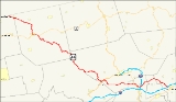
Pennsylvania Route 44 is a 149.24 mi (240.18 km)-long state highway
in the U.S. state
of Pennsylvania
. The route is designated from Interstate 80 and Pennsylvania Route 42
in Buckhorn to the New York state line near New York State Route 417
in Ceres Township
.
Commissioned in 1927 by the Pennsylvania Department of Highways, PA 44 originally ran from the NY
state line to Jersey Shore
. Today, the highway is a scenic route from Union County
to Potter County
.
and exit 232 of Interstate 80. From there, the highway runs northwest as Buckhorn Road through the Appalachians. In Jerseytown
, the route intersects Pennsylvania Route 642
and Pennsylvania Route 254. Outside of Jerseytown, PA 44 turns westward as White Hall Road.
The route enters Montour County
passing through the Muncy Hills. From Schuyler to Turbotville
, Route 44 is concurrent
with Pennsylvania Route 54
at Continental Boulevard.
running southwest through the mainly plain and agricultural sections of the county. In the village of Mcewensville briefly east of the Interstate 180
underpass, the route intersects Main Street, the historic Susquehanna Trail
that was once U.S. Route 111
. From Watsontown
to Dewart, PA 44 is concurrent with PA 405
along Main Street. In Dewart, the route turns west and crosses the West Branch Susquehanna River
via Bridge Avenue.
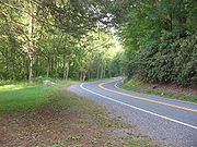
 West of the bridge, PA 44 is designated as a scenic route to the intersection with PA 144
in Potter County
. After crossing the bridge, the route intersects U.S. Route 15
in the Union County
community of Allenwood. West of the hamlet, PA 44 runs mainly west along the banks of the White Deer Hole Creek
in the White Deer Valley.
 The highway enters Lycoming County
in the White Deer Valley area. In the hamlet of Washington at the intersection with Gap Road, PA 44 turns north before intersecting the southern terminus of PA 554
in Elimsport; on the intersection, the highway turns west.
West of Elimsport, the highway crosses the North White Deer Ridge; one of the ridges on the Appalachian Mountain system. West of the ridge, PA 44 intersects the southern terminus of PA 654
in the town of Collomsville. The route proceeds west and upon reaching a gap
that cuts through the Bald Eagle Mountain
range near the intersection with PA 880
, the highway turns north.
North of the gap, the highway turns west and crosses the West Branch Susquehanna River and enters the borough of Jersey Shore
. Inside the borough, PA 44 turns north onto Main Street for a short distance and interchanges the U.S. Route 220
expressway to begin a short 3 mile (5 km) wrong-way concurrency.
The expressway runs mainly southwest, officially signed as the "Frank D. Oreilly Highway". Southwest of the Pine Creek
crossing, PA 44 leaves US 220. PA 44 crosses the creek again and continues north along the western banks of the creek.
In the village of Tomb, PA 44 intersects the western endpoint of PA 973
, where the highway runs through the Pine Creek Gorge
. Near the village of Cummings, PA 44 turns west to cross the Pine Creek and intersect PA 414
. The highway proceeds west through the southern sections of the Tiadaghton State Forest
. Through the reminder of the Lycoming section of PA 44, the highway runs north, serving primarily as the boundary between Lycoming and Clinton Counties
.
 PA 44 enters Potter County
through the western portions of the Tioga State Forest
. At the eastern tip of the Susquehannock State Forest
, PA 44 begins a concurrency with PA 144
; the scenic route continues south, on PA 144. The two routes run briefly on Pine Hill Road. North of the overlap, PA 44 proceeds northwest through more mountainous terrain. This section of PA 44, signed as Cherry Springs Road, traverses many hills and mountains including Mount Brodhead, Cherry Springs Vista, Kaple Hill, and Cochran Hill.
North of the mountainous region, PA 44 turns west to begin a concurrency with U.S. Route 6
, the Grand Army of the Republic
Highway. The two routes run into the borough of Coudersport
, where they split in downtown; US 6 turns south and PA 44 turns north onto Main Street. North of Coudersport, PA 44 meets the western terminus of PA 49
.
The route proceeds northward into the Greenman Hill area. In Coneville, PA 44 intersects the western terminus of PA 244
. From PA 244, the highway proceeds on a northwest direction into the northern tier of Pennsylvania. The highway spends over 55 miles in Potter County. The highway briefly enters McKean County
for about a little over 3 miles, passing through its northeast corner (5 km) before terminating at the New York-Pennsylvania border and becoming a short road (less than 100 yards) that connects to New York State Route 417
.
 When PA 44 was commissioned in 1927, the route was designated from U.S. Route 220
in Jersey Shore
to the New York-Pennsylvania border. Northeast of Coudersport
from PA 49
to PA 244
, and from US 6 to US 220, the road was not paved. From Jersey Shore to Turbotville
, PA 44 was assigned the Pennsylvania Route 54
designation. From Turbotville to Jerseytown
, the road was designated as Pennsylvania Route 454. From Jerseytown to Buckhorn, 44 was numbered as Pennsylvania Route 342.
By 1940, PA 44 was extended east to Turbotville, replacing the previous PA 54 alignment. Also in the 1940s, PA 44 was completely paved from Coudersport to the New York
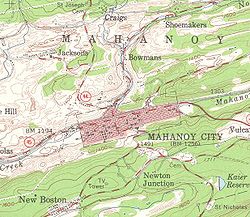
state line. In the 1950s, PA 44 was largely extended to Mahanoy City
in Schuylkill County
.
By 1970, the road was truncated to its current southern terminus in Buckhorn.
State highway
State highway, state road or state route can refer to one of three related concepts, two of them related to a state or provincial government in a country that is divided into states or provinces :#A...
in the U.S. state
U.S. state
A U.S. state is any one of the 50 federated states of the United States of America that share sovereignty with the federal government. Because of this shared sovereignty, an American is a citizen both of the federal entity and of his or her state of domicile. Four states use the official title of...
of Pennsylvania
Pennsylvania
The Commonwealth of Pennsylvania is a U.S. state that is located in the Northeastern and Mid-Atlantic regions of the United States. The state borders Delaware and Maryland to the south, West Virginia to the southwest, Ohio to the west, New York and Ontario, Canada, to the north, and New Jersey to...
. The route is designated from Interstate 80 and Pennsylvania Route 42
Pennsylvania Route 42
Pennsylvania Route 42 is a long state route located in central Pennsylvania. The southern terminus of the route is at Pennsylvania Route 61 in Centralia. The northern terminus is at U.S. Route 220 in Laporte. In Beech Glen, Sullivan County, it concurs with U.S. 220, loops through Eagles Mere and...
in Buckhorn to the New York state line near New York State Route 417
New York State Route 417
New York State Route 417 is an east–west state highway located in the Southern Tier of New York in the United States. It begins at exit 20 of the Southern Tier Expressway in the city of Salamanca and ends at a junction with NY 415 in Painted Post, west of the city of Corning...
in Ceres Township
Ceres Township, Pennsylvania
Ceres Township is a township in McKean County, Pennsylvania, United States. The population was 1,003 at the 2000 census.-Geography:According to the United States Census Bureau, the township has a total area of , all of it land.-Demographics:...
.
Commissioned in 1927 by the Pennsylvania Department of Highways, PA 44 originally ran from the NY
New York
New York is a state in the Northeastern region of the United States. It is the nation's third most populous state. New York is bordered by New Jersey and Pennsylvania to the south, and by Connecticut, Massachusetts and Vermont to the east...
state line to Jersey Shore
Jersey Shore, Pennsylvania
Jersey Shore is a borough in Lycoming County, Pennsylvania, United States. It is on the West Branch Susquehanna River, west by south of Williamsport. It is part of the Williamsport, Pennsylvania Metropolitan Statistical Area. In the past, Jersey Shore held farms, railroad shops, cigar factories, a...
. Today, the highway is a scenic route from Union County
Union County, Pennsylvania
-Demographics:As of the census of 2000, there were 41,624 people, 13,178 households, and 9,211 families residing in the county. The population density was 131 people per square mile . There were 14,684 housing units at an average density of 46 per square mile...
to Potter County
Potter County, Pennsylvania
Potter County is a county located in the U.S. state of Pennsylvania. It is in the Allegheny Plateau region. As of 2010, the population was 17,457. Its county seat is Coudersport. Potter County was named after James Potter, who was a general from Pennsylvania in the Continental Army during the...
.
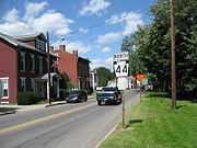
Columbia and Montour Counties
PA 44 begins in the hamlet of Buckhorn at an intersection with Pennsylvania Route 42Pennsylvania Route 42
Pennsylvania Route 42 is a long state route located in central Pennsylvania. The southern terminus of the route is at Pennsylvania Route 61 in Centralia. The northern terminus is at U.S. Route 220 in Laporte. In Beech Glen, Sullivan County, it concurs with U.S. 220, loops through Eagles Mere and...
and exit 232 of Interstate 80. From there, the highway runs northwest as Buckhorn Road through the Appalachians. In Jerseytown
Jerseytown, Pennsylvania
Jerseytown is a census-designated place in Madison Township, Columbia County, Pennsylvania, United States. The population was 150 at the 2000 census...
, the route intersects Pennsylvania Route 642
Pennsylvania Route 642
Pennsylvania Route 642 is an long state highway located in Union, Northumberland, Montour, and Columbia counties in Pennsylvania. The western terminus is at US 15 in Kelly Township. The eastern terminus is at PA 254 in Madison Township....
and Pennsylvania Route 254. Outside of Jerseytown, PA 44 turns westward as White Hall Road.
The route enters Montour County
Montour County, Pennsylvania
Montour County is located in the U.S. state of Pennsylvania. In 2010, the county's population was 18,267. Its county seat is Danville. It is named for Andrew Montour, a prominent métis interpreter who served with George Washington during the French and Indian War. The county is part of the...
passing through the Muncy Hills. From Schuyler to Turbotville
Turbotville, Pennsylvania
Turbotville is a borough in Northumberland County, Pennsylvania, United States. The population was 691 at the 2000 census.-Geography:Turbotville is located at ....
, Route 44 is concurrent
Concurrency (road)
A concurrency, overlap, or coincidence in a road network is an instance of one physical road bearing two or more different highway, motorway, or other route numbers...
with Pennsylvania Route 54
Pennsylvania Route 54
Pennsylvania Route 54 is a state highway which runs for in eastern Pennsylvania. It runs from U.S. Route 209 in Nesquehoning, Carbon County in the east to U.S. Route 15, which is three miles west of Montgomery, Lycoming County in the west...
at Continental Boulevard.
Northumberland and Union Counties
PA 44 enters Northumberland CountyNorthumberland County, Pennsylvania
There were 38,835 households out of which 27.30% had children under the age of 18 living with them, 52.40% were married couples living together, 9.60% had a female householder with no husband present, and 34.10% were non-families. 30.20% of all households were made up of individuals and 15.50% had...
running southwest through the mainly plain and agricultural sections of the county. In the village of Mcewensville briefly east of the Interstate 180
Interstate 180 (Pennsylvania)
Interstate 180 is a spur highway that connects Williamsport, Pennsylvania to Interstate 80 near Milton, Pennsylvania. The length of the highway is . It was also the designation of present-day Interstate 176 between Morgantown, Pennsylvania and Reading, when the Pennsylvania Turnpike carried the...
underpass, the route intersects Main Street, the historic Susquehanna Trail
Susquehanna Trail
The Susquehanna Trail was an auto trail in the United States linking Washington, D.C. with Niagara Falls, New York. It passed through Baltimore, Maryland; Harrisburg, Pennsylvania; Williamsport, Pennsylvania; and Buffalo, New York....
that was once U.S. Route 111
U.S. Route 111
U.S. Route 111 was a U.S. Route that ran from Baltimore, Maryland north to the Harrisburg, Pennsylvania area. It replaced part of the Susquehanna Trail and was in turn replaced by Interstate 83. Portions of its pre-freeway alignment are now Maryland Route 45 and Interstate 83 Business...
. From Watsontown
Watsontown, Pennsylvania
Watsontown is a borough in Northumberland County, Pennsylvania, United States. The population was 2,255 at the 2000 census. It was named for John Watson, a local landowner.-Geography:Watsontown is located at ....
to Dewart, PA 44 is concurrent with PA 405
Pennsylvania Route 405
Pennsylvania Route 405 is a state highway that runs for in north central Pennsylvania, United States. The southern terminus of Pennsylvania Route 147 in West Chillisquaque Township...
along Main Street. In Dewart, the route turns west and crosses the West Branch Susquehanna River
West Branch Susquehanna River
The West Branch Susquehanna River is one of the two principal branches, along with the North Branch, of the Susquehanna River in the northeastern United States. The North Branch, which rises in upstate New York, is generally regarded as the extension of the main branch, with the shorter West Branch...
via Bridge Avenue.
Pennsylvania Route 144
Pennsylvania Route 144 is a state highway located in the US state of Pennsylvania, covering a distance of 109.3 miles . The southern terminus is located at U.S. Route 322 in Potter Township while the northern terminus is located at U.S. Route 6 in Galeton.- History :PA 144 was first designated by...
in Potter County
Potter County, Pennsylvania
Potter County is a county located in the U.S. state of Pennsylvania. It is in the Allegheny Plateau region. As of 2010, the population was 17,457. Its county seat is Coudersport. Potter County was named after James Potter, who was a general from Pennsylvania in the Continental Army during the...
. After crossing the bridge, the route intersects U.S. Route 15
U.S. Route 15
U.S. Route 15 is a -long United States highway, designated along South Carolina, North Carolina, Virginia, Maryland, Pennsylvania, and New York. The route is signed north–south, from U.S. Route 17 Alternate in Walterboro, South Carolina to Interstate 86 and NY 17 in Painted Post, New York.US...
in the Union County
Union County, Pennsylvania
-Demographics:As of the census of 2000, there were 41,624 people, 13,178 households, and 9,211 families residing in the county. The population density was 131 people per square mile . There were 14,684 housing units at an average density of 46 per square mile...
community of Allenwood. West of the hamlet, PA 44 runs mainly west along the banks of the White Deer Hole Creek
White Deer Hole Creek
White Deer Hole Creek is a tributary of the West Branch Susquehanna River in Clinton, Lycoming and Union counties in the U.S. state of Pennsylvania. A part of the Chesapeake Bay drainage basin, the White Deer Hole Creek watershed drains parts of ten townships...
in the White Deer Valley.
Clinton and Lycoming Counties
Lycoming County, Pennsylvania
-Appalachian Mountains and Allegheny Plateau:Lycoming County is divided between the Appalachian Mountains in the south, the dissected Allegheny Plateau in the north and east, and the valley of the West Branch Susquehanna River between these.-West Branch Susquehanna River:The West Branch of the...
in the White Deer Valley area. In the hamlet of Washington at the intersection with Gap Road, PA 44 turns north before intersecting the southern terminus of PA 554
Pennsylvania Route 554
Pennsylvania Route 554 is a highway which runs for 8 miles generally north–south in Lycoming County in north central Pennsylvania in the United States. Its southern terminus is at Pennsylvania Route 44 just north of the unincorporated village of Elimsport in Washington Township and its...
in Elimsport; on the intersection, the highway turns west.
West of Elimsport, the highway crosses the North White Deer Ridge; one of the ridges on the Appalachian Mountain system. West of the ridge, PA 44 intersects the southern terminus of PA 654
Pennsylvania Route 654
Pennsylvania Route 654 is an long state highway located in Lycoming county in Pennsylvania. It is known as West Southern Avenue and Riverside Drive in South Williamsport and Riverside Drive and Euclid Avenue in Duboistown. The western terminus is at PA 44 in Limestone Township. The eastern...
in the town of Collomsville. The route proceeds west and upon reaching a gap
Mountain pass
A mountain pass is a route through a mountain range or over a ridge. If following the lowest possible route, a pass is locally the highest point on that route...
that cuts through the Bald Eagle Mountain
Bald Eagle Mountain
Bald Eagle Mountain, once known locally as Muncy Mountain, is a stratigraphic ridge in central Pennsylvania, United States, running east of the Allegheny Front and northwest of Mount Nittany. It lies along the southeast side of Bald Eagle Creek, and south of the West Branch Susquehanna River, and...
range near the intersection with PA 880
Pennsylvania Route 880
Pennsylvania Route 880 is a long state highway located in Centre, Clinton, and Lycoming counties in Pennsylvania. The southern terminus is at PA 192 in Miles Township. The northern terminus is at PA 44 in Limestone Township...
, the highway turns north.
North of the gap, the highway turns west and crosses the West Branch Susquehanna River and enters the borough of Jersey Shore
Jersey Shore, Pennsylvania
Jersey Shore is a borough in Lycoming County, Pennsylvania, United States. It is on the West Branch Susquehanna River, west by south of Williamsport. It is part of the Williamsport, Pennsylvania Metropolitan Statistical Area. In the past, Jersey Shore held farms, railroad shops, cigar factories, a...
. Inside the borough, PA 44 turns north onto Main Street for a short distance and interchanges the U.S. Route 220
U.S. Route 220
U.S. Route 220 is a long U.S. Route in the eastern United States.US 220 is a spur route of U.S. Route 20 but at present, the two routes do not intersect nor do they connect via other spurs of US 20. The former U. S. Route 120, which was signed in Pennsylvania between 1926 and 1967, intersected...
expressway to begin a short 3 mile (5 km) wrong-way concurrency.
The expressway runs mainly southwest, officially signed as the "Frank D. Oreilly Highway". Southwest of the Pine Creek
Pine Creek (Pennsylvania)
Pine Creek is a tributary of the West Branch Susquehanna River in Potter, Tioga, Lycoming, and Clinton counties in Pennsylvania in the United States. The creek is long...
crossing, PA 44 leaves US 220. PA 44 crosses the creek again and continues north along the western banks of the creek.
In the village of Tomb, PA 44 intersects the western endpoint of PA 973
Pennsylvania Route 973
Pennsylvania Route 973 is a highway which runs for 26 miles generally east–west in Lycoming County in north central Pennsylvania in the United States...
, where the highway runs through the Pine Creek Gorge
Pine Creek Gorge
Pine Creek Gorge, also known as, The Grand Canyon of Pennsylvania, is situated in approximately 160,000 acres of the Tioga State Forest in the U.S. State of Pennsylvania along Pine Creek. The Canyon begins south of Ansonia, near Wellsboro, along U.S. Route 6 and continues for approximately...
. Near the village of Cummings, PA 44 turns west to cross the Pine Creek and intersect PA 414
Pennsylvania Route 414
Pennsylvania Route 414 is an long state highway located in Lycoming, Tioga, and Bradford counties in Pennsylvania. The western terminus is at PA 44 in Waterville...
. The highway proceeds west through the southern sections of the Tiadaghton State Forest
Tiadaghton State Forest
Tiadaghton State Forest is a Pennsylvania State Forest in Pennsylvania Bureau of Forestry District #12. The forest is chiefly in western and southern Lycoming County, with small portions in Clinton, Potter, Tioga, and Union counties....
. Through the reminder of the Lycoming section of PA 44, the highway runs north, serving primarily as the boundary between Lycoming and Clinton Counties
Clinton County, Pennsylvania
As of the census of 2000, there were 37,914 people, 14,773 households, and 9,927 families residing in the county. The population density was 43 people per square mile . There were 18,166 housing units at an average density of 20 per square mile...
.
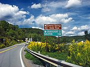
Potter and McKean Counties
Potter County, Pennsylvania
Potter County is a county located in the U.S. state of Pennsylvania. It is in the Allegheny Plateau region. As of 2010, the population was 17,457. Its county seat is Coudersport. Potter County was named after James Potter, who was a general from Pennsylvania in the Continental Army during the...
through the western portions of the Tioga State Forest
Tioga State Forest
Tioga State Forest is a Pennsylvania State Forest in District #16. The main offices are located in Wellsboro in Tioga County, Pennsylvania in the United States....
. At the eastern tip of the Susquehannock State Forest
Susquehannock State Forest
Susquehannock State Forest is a Pennsylvania state forest in Pennsylvania Bureau of Forestry District #15. The main office is located in Coudersport in Potter County, Pennsylvania in the United States....
, PA 44 begins a concurrency with PA 144
Pennsylvania Route 144
Pennsylvania Route 144 is a state highway located in the US state of Pennsylvania, covering a distance of 109.3 miles . The southern terminus is located at U.S. Route 322 in Potter Township while the northern terminus is located at U.S. Route 6 in Galeton.- History :PA 144 was first designated by...
; the scenic route continues south, on PA 144. The two routes run briefly on Pine Hill Road. North of the overlap, PA 44 proceeds northwest through more mountainous terrain. This section of PA 44, signed as Cherry Springs Road, traverses many hills and mountains including Mount Brodhead, Cherry Springs Vista, Kaple Hill, and Cochran Hill.
North of the mountainous region, PA 44 turns west to begin a concurrency with U.S. Route 6
U.S. Route 6 in Pennsylvania
U.S. Route 6 travels east–west near the north edge of the U.S. state of Pennsylvania from the Ohio state line near Pymatuning Reservoir east to the Mid-Delaware Bridge over the Delaware River into Port Jervis, New York. It is the longest highway segment in the Commonwealth. Most of it is a...
, the Grand Army of the Republic
Grand Army of the Republic
The Grand Army of the Republic was a fraternal organization composed of veterans of the Union Army, US Navy, US Marines and US Revenue Cutter Service who served in the American Civil War. Founded in 1866 in Decatur, Illinois, it was dissolved in 1956 when its last member died...
Highway. The two routes run into the borough of Coudersport
Coudersport, Pennsylvania
Coudersport is a borough in Potter County, Pennsylvania, east by south of Erie on the Allegheny River. The populations were these: 1,530 in 1890; 3,217 in 1900; and 3,100 in 1910. The population was 2,650 at the 2000 census...
, where they split in downtown; US 6 turns south and PA 44 turns north onto Main Street. North of Coudersport, PA 44 meets the western terminus of PA 49
Pennsylvania Route 49
Pennsylvania Route 49 is a long state highway located in northern Pennsylvania. The western terminus of the route is at Pennsylvania Route 44 three miles north of Coudersport. The eastern terminus is at PA 287 in Lawrenceville less than south of the New York-Pennsylvania border...
.
The route proceeds northward into the Greenman Hill area. In Coneville, PA 44 intersects the western terminus of PA 244
Pennsylvania Route 244
Pennsylvania Route 244 is an long state highway located in Potter county in Pennsylvania. The western terminus is at PA 44 in Coneville...
. From PA 244, the highway proceeds on a northwest direction into the northern tier of Pennsylvania. The highway spends over 55 miles in Potter County. The highway briefly enters McKean County
McKean County, Pennsylvania
As of the census of 2000, there were 45,936 people, 18,024 households, and 12,094 families residing in the county. The population density was 47 people per square mile . There were 21,644 housing units at an average density of 22 per square mile...
for about a little over 3 miles, passing through its northeast corner (5 km) before terminating at the New York-Pennsylvania border and becoming a short road (less than 100 yards) that connects to New York State Route 417
New York State Route 417
New York State Route 417 is an east–west state highway located in the Southern Tier of New York in the United States. It begins at exit 20 of the Southern Tier Expressway in the city of Salamanca and ends at a junction with NY 415 in Painted Post, west of the city of Corning...
.
History
U.S. Route 220
U.S. Route 220 is a long U.S. Route in the eastern United States.US 220 is a spur route of U.S. Route 20 but at present, the two routes do not intersect nor do they connect via other spurs of US 20. The former U. S. Route 120, which was signed in Pennsylvania between 1926 and 1967, intersected...
in Jersey Shore
Jersey Shore, Pennsylvania
Jersey Shore is a borough in Lycoming County, Pennsylvania, United States. It is on the West Branch Susquehanna River, west by south of Williamsport. It is part of the Williamsport, Pennsylvania Metropolitan Statistical Area. In the past, Jersey Shore held farms, railroad shops, cigar factories, a...
to the New York-Pennsylvania border. Northeast of Coudersport
Coudersport, Pennsylvania
Coudersport is a borough in Potter County, Pennsylvania, east by south of Erie on the Allegheny River. The populations were these: 1,530 in 1890; 3,217 in 1900; and 3,100 in 1910. The population was 2,650 at the 2000 census...
from PA 49
Pennsylvania Route 49
Pennsylvania Route 49 is a long state highway located in northern Pennsylvania. The western terminus of the route is at Pennsylvania Route 44 three miles north of Coudersport. The eastern terminus is at PA 287 in Lawrenceville less than south of the New York-Pennsylvania border...
to PA 244
Pennsylvania Route 244
Pennsylvania Route 244 is an long state highway located in Potter county in Pennsylvania. The western terminus is at PA 44 in Coneville...
, and from US 6 to US 220, the road was not paved. From Jersey Shore to Turbotville
Turbotville, Pennsylvania
Turbotville is a borough in Northumberland County, Pennsylvania, United States. The population was 691 at the 2000 census.-Geography:Turbotville is located at ....
, PA 44 was assigned the Pennsylvania Route 54
Pennsylvania Route 54
Pennsylvania Route 54 is a state highway which runs for in eastern Pennsylvania. It runs from U.S. Route 209 in Nesquehoning, Carbon County in the east to U.S. Route 15, which is three miles west of Montgomery, Lycoming County in the west...
designation. From Turbotville to Jerseytown
Jerseytown, Pennsylvania
Jerseytown is a census-designated place in Madison Township, Columbia County, Pennsylvania, United States. The population was 150 at the 2000 census...
, the road was designated as Pennsylvania Route 454. From Jerseytown to Buckhorn, 44 was numbered as Pennsylvania Route 342.
By 1940, PA 44 was extended east to Turbotville, replacing the previous PA 54 alignment. Also in the 1940s, PA 44 was completely paved from Coudersport to the New York
New York
New York is a state in the Northeastern region of the United States. It is the nation's third most populous state. New York is bordered by New Jersey and Pennsylvania to the south, and by Connecticut, Massachusetts and Vermont to the east...
state line. In the 1950s, PA 44 was largely extended to Mahanoy City
Mahanoy City, Pennsylvania
Mahanoy City is a borough located north by west of Reading and 13 miles southwest of Hazleton, in northern Schuylkill County, Pennsylvania or the southern Coal Region. The name "Mahanoy" is believed to be a variation of the Native American word 'Maghonioy', or "the salt deposits"...
in Schuylkill County
Schuylkill County, Pennsylvania
-Notable people:*Boxing heavyweight great Muhammad Ali had his training camp in Deer Lake.*Charles Justin Bailey, commanding general of the 81st Division in World War I, was born in Tamaqua on June 21, 1859....
.
By 1970, the road was truncated to its current southern terminus in Buckhorn.