

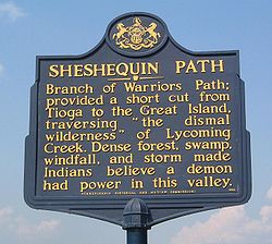
Sheshequin Path
Encyclopedia
Native Americans in the United States
Native Americans in the United States are the indigenous peoples in North America within the boundaries of the present-day continental United States, parts of Alaska, and the island state of Hawaii. They are composed of numerous, distinct tribes, states, and ethnic groups, many of which survive as...
trail
Trail
A trail is a path with a rough beaten or dirt/stone surface used for travel. Trails may be for use only by walkers and in some places are the main access route to remote settlements...
in the U.S. State
U.S. state
A U.S. state is any one of the 50 federated states of the United States of America that share sovereignty with the federal government. Because of this shared sovereignty, an American is a citizen both of the federal entity and of his or her state of domicile. Four states use the official title of...
of Pennsylvania
Pennsylvania
The Commonwealth of Pennsylvania is a U.S. state that is located in the Northeastern and Mid-Atlantic regions of the United States. The state borders Delaware and Maryland to the south, West Virginia to the southwest, Ohio to the west, New York and Ontario, Canada, to the north, and New Jersey to...
that ran between two Native American villages: "French Margaret's Town" on the West Branch Susquehanna River
West Branch Susquehanna River
The West Branch Susquehanna River is one of the two principal branches, along with the North Branch, of the Susquehanna River in the northeastern United States. The North Branch, which rises in upstate New York, is generally regarded as the extension of the main branch, with the shorter West Branch...
(part of modern day Williamsport
Williamsport, Pennsylvania
Williamsport is a city in and the county seat of Lycoming County, Pennsylvania in the United States. In 2009, the population was estimated at 29,304...
in Lycoming County
Lycoming County, Pennsylvania
-Appalachian Mountains and Allegheny Plateau:Lycoming County is divided between the Appalachian Mountains in the south, the dissected Allegheny Plateau in the north and east, and the valley of the West Branch Susquehanna River between these.-West Branch Susquehanna River:The West Branch of the...
) and "Sheshequin" on the North Branch of the Susquehanna River
Susquehanna River
The Susquehanna River is a river located in the northeastern United States. At long, it is the longest river on the American east coast that drains into the Atlantic Ocean, and with its watershed it is the 16th largest river in the United States, and the longest river in the continental United...
(modern day Ulster Township
Ulster Township, Pennsylvania
Ulster Township is a township in Bradford County, Pennsylvania, United States. The population was 1,340 at the 2000 census.It was named after the province of Ulster in Ireland.-Geography:...
, in Bradford County
Bradford County, Pennsylvania
-Demographics:As of the census of 2000, there were 62,761 people, 24,453 households, and 17,312 families residing in the county. The population density was 54 people per square mile . There were 28,664 housing units at an average density of 25 per square mile...
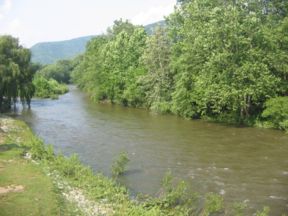
). The path ran north and east along Lycoming Creek
Lycoming Creek
Lycoming Creek is a tributary of the West Branch Susquehanna River located in Tioga and Lycoming counties in Pennsylvania in the United States.-Geography:...
in Lycoming County and followed much of Towanda Creek
Towanda Creek
thumb|right|250px|Towanda CreekTowanda Creek is a tributary of the Susquehanna River in Bradford County, Pennsylvania, in the United States.Towanda Creek rises in the southwest corner of Bradford County, south of Canton, and flows east, joining the Susquehanna River just below...
in Bradford County. It was a shortcut between the two main branches of the Susquehanna River and was used by early settlers as well as Native Americans.
Name
The name Sheshequin is a corruption of Sheshequanink meaning "at the place of the gourd rattle" in the Lenape languageLenape language
The Delaware languages, also known as the Lenape languages, are Munsee and Unami, two closely related languages of the Eastern Algonquian subgroup of the Algonquian language family...
. The gourd rattle was used in religious ceremonies held there. Another name for the trail was the "Lycoming Path" for the creek it runs along for much of its length, which also gave its name to Lycoming County. Lycoming is a corruption of the Lenape Legaui-hanne or "sandy stream". A shortcut near Sheshequin which bypassed Towanda
Towanda, Pennsylvania
Towanda is a borough in and the county seat of Bradford County, Pennsylvania, United States, northwest of Wilkes Barre, on the Susquehanna River. The name means "burial ground" in the Algonquian language...
was known as "St. Joseph's Path", believed to be named for the Moravian Bishop
Bishop
A bishop is an ordained or consecrated member of the Christian clergy who is generally entrusted with a position of authority and oversight. Within the Catholic Church, Eastern Orthodox, Oriental Orthodox Churches, in the Assyrian Church of the East, in the Independent Catholic Churches, and in the...
August Gottlieb Spangenberg
August Gottlieb Spangenberg
August Gottlieb Spangenberg was a German theologian and minister, and a bishop of the Moravian Brethren. As successor of Count Nicolaus Ludwig Zinzendorf, he helped develop international missions, as well as stabilize the theology and organization of the German Moravian Church.-Early life and...
, who was also known as "Brother Joseph".
Course
As was often the case with Native American trails, the Sheshequin Path split into multiple pathways at each end. In Lycoming County there were three branches that eventually led to Lycoming Creek. Each connected with the Great Shamokin PathGreat Shamokin Path
The Great Shamokin Path was a major Native American trail in the U.S. State of Pennsylvania that ran from the native village of Shamokin along the left bank of the West Branch Susquehanna River north and then west to the Great Island...
that ran along the West Branch Susquehanna River south to the village of Shamokin
Shamokin (village)
Shamokin was a multi-ethnic Native American trading village on the Susquehanna River, located near the site of the modern Sunbury, Pennsylvania. Early in the eighteenth century, the village consisted of Iroquois migrants from the north, as well as Shawnee and Lenape settlers moving away from the...
(modern Sunbury
Sunbury, Pennsylvania
Sunbury is a city in Northumberland County, Pennsylvania, United States. The city is located on the east bank of the Susquehanna River, just downstream of the confluence of its main and West branches. The population was 9,905 at the 2010 census...
) and west to the "Great Island" (at modern Lock Haven
Lock Haven, Pennsylvania
The city of Lock Haven is the county seat of Clinton County, in the U.S. state of Pennsylvania. Located near the confluence of the West Branch Susquehanna River and Bald Eagle Creek, it is the principal city of the Lock Haven, Pennsylvania, micropolitan statistical area, itself part of the...
) and further west to Kittaning on the Allegheny River
Allegheny River
The Allegheny River is a principal tributary of the Ohio River; it is located in the Eastern United States. The Allegheny River joins with the Monongahela River to form the Ohio River at the "Point" of Point State Park in Downtown Pittsburgh, Pennsylvania...
.
The east branch followed Loyalsock Creek
Loyalsock Creek
Loyalsock Creek is a tributary of the West Branch Susquehanna River located chiefly in Sullivan and Lycoming counties in Pennsylvania in the United States...
north from its mouth at the village of "Otstonwakin" (modern Montoursville
Montoursville, Pennsylvania
Montoursville is a borough in Lycoming County, Pennsylvania, in the United States. As of the 2000 census, the borough population was 4,777. It is part of the Williamsport, Pennsylvania Metropolitan Statistical Area. It was named for Madame Montour, a Native American leader and skilled interpreter...
) to Wallis Run
Wallis Run
Wallis Run is a tributary of Loyalsock Creek in Lycoming County, Pennsylvania, in the United States. It gives its name to the community of Wallis Run, located along the stream where it turns from southward to westward.-References:...
, north there, then west to Lycoming Creek along either Murray Run to the village of Fields Station, or that and Slacks Run to the village of Bodines. The middle branch was about one mile (0.6 km) west of Loyalsock Creek and ran north along Millers Run (Northway Road in Loyalsock Township
Loyalsock Township, Pennsylvania
Loyalsock Township is a township in Lycoming County, Pennsylvania, in the United States. The population was 10,876 at the 2000 census. It is part of the Williamsport, Pennsylvania Metropolitan Statistical Area.-History:...
), then followed Log Run or Mill Creek west to Lycoming Creek. The western main branch started at French Margaret's Town on the western side of Lycoming Creek, just north of its confluence
Confluence (geography)
In geography, a confluence is the meeting of two or more bodies of water. It usually refers to the point where two streams flow together, merging into a single stream...
with the river (today the Newberry section of Williamsport). This branch can be viewed as a continuation of Culbertson's Path
Culbertson's Path
Culbertson's Path was a Native American trail in north central Pennsylvania in the United States, which connected the Great Island Path with the Sheshequin Path. The eastern / southern end of the path was on the West Branch Susquehanna River at what is now the unincorporated village of Allenwood in...
, which crossed the river here.
The main branch of the Sheshequin Path followed Lycoming Creek north past the modern villages of Hepburnville, Cogan Station and Trout Run (the modern path of U.S. Route 15
U.S. Route 15
U.S. Route 15 is a -long United States highway, designated along South Carolina, North Carolina, Virginia, Maryland, Pennsylvania, and New York. The route is signed north–south, from U.S. Route 17 Alternate in Walterboro, South Carolina to Interstate 86 and NY 17 in Painted Post, New York.US...
and the future Interstate 99
Interstate 99
Interstate 99 is an intrastate Interstate Highway located in central Pennsylvania in the United States. The southern terminus of the route is at exit 146 of the Pennsylvania Turnpike north of Bedford, where the road continues south as U.S. Route 220 . The northern terminus is at...
). From Trout Run it continues past Fields Station, Bodines, Marsh Hill, Ralston to the source
Source (river or stream)
The source or headwaters of a river or stream is the place from which the water in the river or stream originates.-Definition:There is no universally agreed upon definition for determining a stream's source...
of Lycoming Creek in the southwest corner of Bradford County. There the path traversed a swamp
Swamp
A swamp is a wetland with some flooding of large areas of land by shallow bodies of water. A swamp generally has a large number of hammocks, or dry-land protrusions, covered by aquatic vegetation, or vegetation that tolerates periodical inundation. The two main types of swamp are "true" or swamp...
y area for a short distance to the source of Towanda Creek near Grover, following Towanda Creek northeast to modern Canton
Canton, Pennsylvania
Canton is a borough in Bradford County, Pennsylvania, United States. The population was 1,807 at the 2000 census.-Geography:Canton is located at ....
(this is the route of Pennsylvania Route 14
Pennsylvania Route 14
Pennsylvania Route 14 is a Pennsylvania highway that runs for . It runs from U.S. Route 15 in Trout Run, Pennsylvania to the New York-Pennsylvania border at Fassett, Pennsylvania, co-signed with U.S. Route 6 for a short distance in Troy...
) and on to the village of East Canton. A short cut left the creek between Grover and East Canton. From East Canton the path followed the creek past Leroy, West Franklin, Powell, and Monroeton to the creek's mouth at modern Towanda on the North Branch Susuquehanna River. The path then followed the river north to Sheshequin (and from there north to modern New York
New York
New York is a state in the Northeastern region of the United States. It is the nation's third most populous state. New York is bordered by New Jersey and Pennsylvania to the south, and by Connecticut, Massachusetts and Vermont to the east...
and the Iroquois
Iroquois
The Iroquois , also known as the Haudenosaunee or the "People of the Longhouse", are an association of several tribes of indigenous people of North America...
there). The alternate branch known as St. Joseph's Path left Towanda Creek at Powell, and ran north to Sugar Creek
Sugar Creek
Sugar Creek may refer to:In communities:*Sugar Creek, Indiana, a small town in Shelby County, Indiana*Sugar Creek, Iowa, a township in Poweshiek County, Iowa*Sugar Creek, Missouri, a city in Jackson County, Missouri...
, which it either followed to the river and the village of Oscalui then north to Sheshequin, or crossed to go on to Sheshequin. Pennsylvania Route 414
Pennsylvania Route 414
Pennsylvania Route 414 is an long state highway located in Lycoming, Tioga, and Bradford counties in Pennsylvania. The western terminus is at PA 44 in Waterville...
follows the path from Canton to Monroeton, and U.S. Route 220
U.S. Route 220
U.S. Route 220 is a long U.S. Route in the eastern United States.US 220 is a spur route of U.S. Route 20 but at present, the two routes do not intersect nor do they connect via other spurs of US 20. The former U. S. Route 120, which was signed in Pennsylvania between 1926 and 1967, intersected...
follows it to Towanda and north along the river to Sheshequin.
History
Valley
In geology, a valley or dale is a depression with predominant extent in one direction. A very deep river valley may be called a canyon or gorge.The terms U-shaped and V-shaped are descriptive terms of geography to characterize the form of valleys...
s). The narrow valleys made it difficult to avoid flooding, which could be a particular problem on Lycoming Creek. Bohemia Mountain at the headwaters of Lycoming Creek was said to be the residence of an "Otkan" or evil spirit because of the many thunderstorm
Thunderstorm
A thunderstorm, also known as an electrical storm, a lightning storm, thundershower or simply a storm is a form of weather characterized by the presence of lightning and its acoustic effect on the Earth's atmosphere known as thunder. The meteorologically assigned cloud type associated with the...
s and other bad weather there.
The Sheshequin Path was the one Conrad Weiser
Conrad Weiser
Weiser's colonial service began in 1731. The Iroquois sent Shikellamy, an Oneida chief, as an emissary to other tribes and the British. Shikellamy lived on the Susquehanna River at Shamokin village, near present-day Sunbury, Pennsylvania. An oral tradition holds that Weiser met Shikellamy while...
always used in his many journeys to meet with the Six Nations of the Iroquois, and his journal descriptions of his travels on it are a primary source of information about the path. For example, in March 1737 he travelled it with the Iroquois "vice chief" Shikellamy
Shikellamy
Shikellamy , also known as Swatana, was an Oneida chief and overseer for the Iroquois confederacy. In his position as chief and overseer, Shikellamy served as a supervisor for the Six Nations, overseeing the Shawnee and Lenape tribes in central Pennsylvania along the Susquehanna River and...
through snow up to three feet (1 m) deep on their way to Onondaga
Onondaga (village)
Onondaga was a village that served as the capital of the Iroquois League and the primary settlement of the Onondaga nation. It was the meeting place of the Iroquois Grand Council....
(modern Syracuse, New York
Syracuse, New York
Syracuse is a city in and the county seat of Onondaga County, New York, United States, the largest U.S. city with the name "Syracuse", and the fifth most populous city in the state. At the 2010 census, the city population was 145,170, and its metropolitan area had a population of 742,603...
). John Bartram
John Bartram
*Hoffmann, Nancy E. and John C. Van Horne, eds., America’s Curious Botanist: A Tercentennial Reappraisal of John Bartram 1699-1777. Memoirs of the American Philosophical Society, vol. 243. ....
and Lewis Evans
Lewis Evans (surveyor)
Lewis Evans , was a Welsh surveyor and geographer, working principally in British America.Lewis Evans was born in Caernarfonshire, Wales...
travelled the Sheshequin path with Weiser in 1743.
In 1745 a party of Moravians, including Bishop Spangenberg and David Zeisberger
David Zeisberger
David Zeisberger was a Moravian clergyman and missionary among the Native Americans in the Thirteen Colonies...
, went north with Weiser along the trail. Spangenberg wrote of the Sheshequin Path as traversing a "Dismal Wilderness" which was "so full of wood and trees which the wind has piled up sometimes three to four logs upon one another that often one does not know how one may get through." He also wrote of it as "a wilderness where one does not see the sun all day long. The woods are so thickly grown that sometimes one can hardly see twenty paces ahead."
The Sheshequin Path was used by both sides in the American Revolutionary War
American Revolutionary War
The American Revolutionary War , the American War of Independence, or simply the Revolutionary War, began as a war between the Kingdom of Great Britain and thirteen British colonies in North America, and ended in a global war between several European great powers.The war was the result of the...
. In 1778 after the Wyoming Valley battle and massacre, American Colonel Hartley led 200 men north along the Sheshequin Path on a retaliatory raid as far north as Queen Esther's Town (south of modern Athens, Pennsylvania
Athens, Pennsylvania
Athens is a borough in Bradford County, Pennsylvania, two miles south of the N. Y. State line on the Susquehanna and Chemung rivers. Population in 1900, 3,749; and in 1910, 3,796. The population was 3,415 at the 2000 census...
at the confluence
Confluence
Confluence, in geography, describes the meeting of two or more bodies of water.Confluence may also refer to:* Confluence , a property of term rewriting systems...
of the Chemung River
Chemung River
The Chemung River is a tributary of the Susquehanna River, approximately long, in south central New York and northern Pennsylvania in the United States. It drains a mountainous region of the northern Allegheny Plateau in the Southern Tier of New York...
and the Susquehanna), which they destroyed. Hartley's force then followed the river back south and fought a battle with Native Americans south of Wyalusing
Wyalusing, Pennsylvania
Wyalusing is a borough in Bradford County, Pennsylvania, United States. The population was 564 at the 2000 census.- History :The history of Wyalusing dates back centuries and was originally known as M'chwihilusing. Before 1750 the settlement was known as Gahontoto and was home to the native...
. This showed the practicality of raids using the native paths, leading to Sullivan's Expedition in 1779, which destroyed over 40 Native American villages.
The Sheshequin Path was used as a part of the Underground Railroad
Underground Railroad
The Underground Railroad was an informal network of secret routes and safe houses used by 19th-century black slaves in the United States to escape to free states and Canada with the aid of abolitionists and allies who were sympathetic to their cause. The term is also applied to the abolitionists,...
until the American Civil War
American Civil War
The American Civil War was a civil war fought in the United States of America. In response to the election of Abraham Lincoln as President of the United States, 11 southern slave states declared their secession from the United States and formed the Confederate States of America ; the other 25...
began in 1861. Escaped slaves would often wade in creeks to hide their scent from pursuing bloodhound
Bloodhound
The Bloodhound is a large breed of dog which, while originally bred to hunt deer and wild boar, was later bred specifically to track human beings. It is a scenthound, tracking by smell, as opposed to a sighthound, which tracks using vision. It is famed for its ability to discern human odors even...
s.