
Washington Township, Lycoming County, Pennsylvania
Encyclopedia
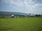
Washington Township is a township in Lycoming County
, Pennsylvania
, in the United States. The population was 1,613 at the 2000 census. It is part of the Williamsport
, Pennsylvania Metropolitan Statistical Area.
in 1786. It originally extended from White Deer Hole Creek
north to the West Branch Susquehanna River
with its eastern boundary also formed by the west branch. The western limit was ambiguous, but most historians assumed that the western boundary followed a line that extended to the south opposite the mouth of Pine Creek
in what is now eastern Clinton County
. Washington Township is older than Lycoming County
. Therefore it was one of the original townships in Lycoming County. Seven additional townships were created from land that was originally part of Washington Township. They are Armstrong
, Bastress, Brady
, Clinton
, Limestone
, Nippenose, and Susquehanna Townships
. The township is named for the hero of the American Revolution
and the 1st President of the United States
, George Washington
.
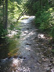
Historically, two trails of the native indigenous peoples ran along parts of White Deer Hole Creek
in Washington Township. Settlers arrived by 1760, but fled in 1778 during the American Revolutionary War
during The Big Runaway. They returned and the creek served as the southern boundary of Lycoming County and Washington Township when it was formed in 1795. A logging railroad ran along the creek from 1901 to 1904 for timber clearcutting
and small-scale lumbering continues.
 The Great Island Path
was a major trail that ran north along the Susquehanna River from the Saponi village of Shamokin
at modern Sunbury
, fording the river there and following the west bank of the West Branch Susquehanna River north until White Deer Hole valley. The path turned west at Allenwood and followed White Deer Hole Creek until about the present location of Elimsport in Washington Township. There it headed northwest, crossed North White Deer Ridge and passed west through the Nippenose valley, then turned north and crossed Bald Eagle Mountain
via McElhattan Creek and ran along the south bank of the river to the Great Island (near the present day city of Lock Haven
).
In the American Revolutionary War, settlements throughout the Susquehanna valley were attacked by Loyalists
and Native Americans allied with the British. After the Wyoming Valley battle and massacre in the summer of 1778 (near what is now Wilkes-Barre
) and smaller local attacks, the Big Runaway occurred throughout the West Branch Susquehanna valley. Settlers fled feared and actual attacks by the British and their allies. Settlers abandoned their homes and fields, drove their livestock south, and towed their possessions on rafts on the river to Sunbury
. Their abandoned property was burnt by the attackers. Some settlers soon returned, only to flee again in the summer of 1779 in the "Little Runaway".
Beginning with the first settlers, much of the land along White Deer Hole Creek in Washington Township was slowly cleared of timber. Small sawmills were built in the 19th century, and a much larger lumber operation was run by the Vincent Lumber Company from 1901 to 1904. They built a narrow gauge railroad from Elimsport 5 miles (8 km) west into timber, and a line east to Allenwood in Union County and the Reading Railroad there. The lumber railroad ran parallel to the creek, with the end of the track near the Fourth Gap. It was incorporated on June 24, 1901 (around the time of construction) as the "Allenwood and Western Railroad". The lumbering operation ceased in 1904 when the forests were gone. The railroad was torn up, and its one second-hand Shay locomotive
was moved to the Vincent Lumber Company operation at Denholm (in Juniata County
).
From 1900 to 1935, much of what is now Tiadaghton State Forest
was purchased by Pennsylvania from lumber companies that had no further use for the clear-cut land. In the 1930s there were seven Civilian Conservation Corps
camps to construct roads and trails in the forest.
Small-scale lumbering continues in the Washington Township, but the forest is certified as well-managed "in an environmentally sensitive manner" and lumber from it qualifies for a "green label". A sawmill owned and operated by Amish is on Pennsylvania Route 44
in Elimsport. It burned down on May 10, 2006 (causing $500,000 in damages) but was expected to be back in operation in a month. Despite this small-scale lumbering, as of 2006 the forests have grown back and are mixed oak
, with blueberry
and mountain laurel
bushes. White Deer Hole Creek and its tributaries also have stands of hemlock and thickets of rhododendron
along them.
to the west, Limestone Township to the northwest, Armstrong Township to the north, Brady Township to the northeast, and Union County
to the east and south. As the crow flies
, Lycoming County is about 130 miles (209 km) northwest of Philadelphia and 165 miles (266 km) east-northeast of Pittsburgh.
According to the United States Census Bureau
, the township has a total area of 48.5 square miles (125.7 km²), all of it land.
of 2000, there were 1,613 people, 549 households, and 462 families residing in the township. The population density
was 33.2 people per square mile (12.8/km²). There were 639 housing units at an average density of 13.2/sq mi (5.1/km²). The racial makeup of the township was 98.57% White, 0.19% African American, 0.37% Native American, 0.12% Asian, 0.12% from other races
, and 0.62% from two or more races. Hispanic or Latino of any race were 0.19% of the population.
 There were 549 households out of which 39.2% had children under the age of 18 living with them, 76.7% were married couples
living together, 4.7% had a female householder with no husband present, and 15.8% were non-families. 13.1% of all households were made up of individuals and 6.0% had someone living alone who was 65 years of age or older. The average household size was 2.94 and the average family size was 3.21.
In the township the population was spread out with 28.9% under the age of 18, 7.1% from 18 to 24, 28.5% from 25 to 44, 24.5% from 45 to 64, and 11.1% who were 65 years of age or older. The median age was 36 years. For every 100 females there were 108.4 males. For every 100 females age 18 and over, there were 104.5 males.
The median income for a household in the township was $41,739, and the median income for a family was $45,804. Males had a median income of $31,098 versus $22,031 for females. The per capita income
for the township was $17,124. About 6.5% of families and 10.3% of the population were below the poverty line, including 17.4% of those under age 18 and 4.0% of those age 65 or over.
Lycoming County, Pennsylvania
-Appalachian Mountains and Allegheny Plateau:Lycoming County is divided between the Appalachian Mountains in the south, the dissected Allegheny Plateau in the north and east, and the valley of the West Branch Susquehanna River between these.-West Branch Susquehanna River:The West Branch of the...
, Pennsylvania
Pennsylvania
The Commonwealth of Pennsylvania is a U.S. state that is located in the Northeastern and Mid-Atlantic regions of the United States. The state borders Delaware and Maryland to the south, West Virginia to the southwest, Ohio to the west, New York and Ontario, Canada, to the north, and New Jersey to...
, in the United States. The population was 1,613 at the 2000 census. It is part of the Williamsport
Williamsport, Pennsylvania
Williamsport is a city in and the county seat of Lycoming County, Pennsylvania in the United States. In 2009, the population was estimated at 29,304...
, Pennsylvania Metropolitan Statistical Area.
History
Washington Township was formed as part of Northumberland CountyNorthumberland County, Pennsylvania
There were 38,835 households out of which 27.30% had children under the age of 18 living with them, 52.40% were married couples living together, 9.60% had a female householder with no husband present, and 34.10% were non-families. 30.20% of all households were made up of individuals and 15.50% had...
in 1786. It originally extended from White Deer Hole Creek
White Deer Hole Creek
White Deer Hole Creek is a tributary of the West Branch Susquehanna River in Clinton, Lycoming and Union counties in the U.S. state of Pennsylvania. A part of the Chesapeake Bay drainage basin, the White Deer Hole Creek watershed drains parts of ten townships...
north to the West Branch Susquehanna River
West Branch Susquehanna River
The West Branch Susquehanna River is one of the two principal branches, along with the North Branch, of the Susquehanna River in the northeastern United States. The North Branch, which rises in upstate New York, is generally regarded as the extension of the main branch, with the shorter West Branch...
with its eastern boundary also formed by the west branch. The western limit was ambiguous, but most historians assumed that the western boundary followed a line that extended to the south opposite the mouth of Pine Creek
Pine Creek (Pennsylvania)
Pine Creek is a tributary of the West Branch Susquehanna River in Potter, Tioga, Lycoming, and Clinton counties in Pennsylvania in the United States. The creek is long...
in what is now eastern Clinton County
Clinton County, Pennsylvania
As of the census of 2000, there were 37,914 people, 14,773 households, and 9,927 families residing in the county. The population density was 43 people per square mile . There were 18,166 housing units at an average density of 20 per square mile...
. Washington Township is older than Lycoming County
Lycoming County, Pennsylvania
-Appalachian Mountains and Allegheny Plateau:Lycoming County is divided between the Appalachian Mountains in the south, the dissected Allegheny Plateau in the north and east, and the valley of the West Branch Susquehanna River between these.-West Branch Susquehanna River:The West Branch of the...
. Therefore it was one of the original townships in Lycoming County. Seven additional townships were created from land that was originally part of Washington Township. They are Armstrong
Armstrong Township, Lycoming County, Pennsylvania
Armstrong Township is a township in Lycoming County, Pennsylvania, in the United States. The population was 717 at the 2000 census. It is part of the Williamsport, Pennsylvania Metropolitan Statistical Area.-History:...
, Bastress, Brady
Brady Township, Lycoming County, Pennsylvania
Brady Township is a township in Lycoming County, Pennsylvania, in the United States. The population was 494 at the 2000 census. It is part of the Williamsport, Pennsylvania Metropolitan Statistical Area.-History:...
, Clinton
Clinton Township, Lycoming County, Pennsylvania
Clinton Township is a township in Lycoming County, Pennsylvania, in the United States. The population was 3,947 at the 2000 census. It is part of the Williamsport, Pennsylvania Metropolitan Statistical Area.-History:...
, Limestone
Limestone Township, Lycoming County, Pennsylvania
Limestone Township is a township in Lycoming County, Pennsylvania, in the United States. The population was 2,136 at the 2000 census. It is part of the Williamsport, Pennsylvania Metropolitan Statistical Area.-History:...
, Nippenose, and Susquehanna Townships
Susquehanna Township, Lycoming County, Pennsylvania
Susquehanna Township is a township in Lycoming County, Pennsylvania, in the United States. The population was 993 at the 2000 census. It is part of the Williamsport, Pennsylvania Metropolitan Statistical Area.-History:...
. The township is named for the hero of the American Revolution
American Revolution
The American Revolution was the political upheaval during the last half of the 18th century in which thirteen colonies in North America joined together to break free from the British Empire, combining to become the United States of America...
and the 1st President of the United States
President of the United States
The President of the United States of America is the head of state and head of government of the United States. The president leads the executive branch of the federal government and is the commander-in-chief of the United States Armed Forces....
, George Washington
George Washington
George Washington was the dominant military and political leader of the new United States of America from 1775 to 1799. He led the American victory over Great Britain in the American Revolutionary War as commander-in-chief of the Continental Army from 1775 to 1783, and presided over the writing of...
.
Historically, two trails of the native indigenous peoples ran along parts of White Deer Hole Creek
White Deer Hole Creek
White Deer Hole Creek is a tributary of the West Branch Susquehanna River in Clinton, Lycoming and Union counties in the U.S. state of Pennsylvania. A part of the Chesapeake Bay drainage basin, the White Deer Hole Creek watershed drains parts of ten townships...
in Washington Township. Settlers arrived by 1760, but fled in 1778 during the American Revolutionary War
American Revolution
The American Revolution was the political upheaval during the last half of the 18th century in which thirteen colonies in North America joined together to break free from the British Empire, combining to become the United States of America...
during The Big Runaway. They returned and the creek served as the southern boundary of Lycoming County and Washington Township when it was formed in 1795. A logging railroad ran along the creek from 1901 to 1904 for timber clearcutting
Clearcutting
Clearcutting, or clearfelling, is a controversial forestry/logging practice in which most or all trees in an area are uniformly cut down. Clearcutting, along with shelterwood and seed tree harvests, is used by foresters to create certain types of forest ecosystems and to promote select species that...
and small-scale lumbering continues.
Great Island Path
The Great Island Path was a major Native American trail in the U.S. State of Pennsylvania that ran from the village of Shamokin along the right bank of the West Branch Susquehanna River north and then west to the Great Island .The village of Shamokin was just south of the "forks of the...
was a major trail that ran north along the Susquehanna River from the Saponi village of Shamokin
Shamokin (village)
Shamokin was a multi-ethnic Native American trading village on the Susquehanna River, located near the site of the modern Sunbury, Pennsylvania. Early in the eighteenth century, the village consisted of Iroquois migrants from the north, as well as Shawnee and Lenape settlers moving away from the...
at modern Sunbury
Sunbury, Pennsylvania
Sunbury is a city in Northumberland County, Pennsylvania, United States. The city is located on the east bank of the Susquehanna River, just downstream of the confluence of its main and West branches. The population was 9,905 at the 2010 census...
, fording the river there and following the west bank of the West Branch Susquehanna River north until White Deer Hole valley. The path turned west at Allenwood and followed White Deer Hole Creek until about the present location of Elimsport in Washington Township. There it headed northwest, crossed North White Deer Ridge and passed west through the Nippenose valley, then turned north and crossed Bald Eagle Mountain
Bald Eagle Mountain
Bald Eagle Mountain, once known locally as Muncy Mountain, is a stratigraphic ridge in central Pennsylvania, United States, running east of the Allegheny Front and northwest of Mount Nittany. It lies along the southeast side of Bald Eagle Creek, and south of the West Branch Susquehanna River, and...
via McElhattan Creek and ran along the south bank of the river to the Great Island (near the present day city of Lock Haven
Lock Haven, Pennsylvania
The city of Lock Haven is the county seat of Clinton County, in the U.S. state of Pennsylvania. Located near the confluence of the West Branch Susquehanna River and Bald Eagle Creek, it is the principal city of the Lock Haven, Pennsylvania, micropolitan statistical area, itself part of the...
).
In the American Revolutionary War, settlements throughout the Susquehanna valley were attacked by Loyalists
Loyalist (American Revolution)
Loyalists were American colonists who remained loyal to the Kingdom of Great Britain during the American Revolutionary War. At the time they were often called Tories, Royalists, or King's Men. They were opposed by the Patriots, those who supported the revolution...
and Native Americans allied with the British. After the Wyoming Valley battle and massacre in the summer of 1778 (near what is now Wilkes-Barre
Wilkes-Barre, Pennsylvania
Wilkes-Barre is a city in the U.S. state of Pennsylvania, the county seat of Luzerne County. It is at the center of the Wyoming Valley area and is one of the principal cities in the Scranton/Wilkes-Barre metropolitan area, which had a population of 563,631 as of the 2010 Census...
) and smaller local attacks, the Big Runaway occurred throughout the West Branch Susquehanna valley. Settlers fled feared and actual attacks by the British and their allies. Settlers abandoned their homes and fields, drove their livestock south, and towed their possessions on rafts on the river to Sunbury
Sunbury, Pennsylvania
Sunbury is a city in Northumberland County, Pennsylvania, United States. The city is located on the east bank of the Susquehanna River, just downstream of the confluence of its main and West branches. The population was 9,905 at the 2010 census...
. Their abandoned property was burnt by the attackers. Some settlers soon returned, only to flee again in the summer of 1779 in the "Little Runaway".
Beginning with the first settlers, much of the land along White Deer Hole Creek in Washington Township was slowly cleared of timber. Small sawmills were built in the 19th century, and a much larger lumber operation was run by the Vincent Lumber Company from 1901 to 1904. They built a narrow gauge railroad from Elimsport 5 miles (8 km) west into timber, and a line east to Allenwood in Union County and the Reading Railroad there. The lumber railroad ran parallel to the creek, with the end of the track near the Fourth Gap. It was incorporated on June 24, 1901 (around the time of construction) as the "Allenwood and Western Railroad". The lumbering operation ceased in 1904 when the forests were gone. The railroad was torn up, and its one second-hand Shay locomotive
Shay locomotive
The Shay locomotive was the most widely used geared steam locomotive. The locomotives were built to the patents of Ephraim Shay, who has been credited with the popularization of the concept of a geared steam locomotive...
was moved to the Vincent Lumber Company operation at Denholm (in Juniata County
Juniata County, Pennsylvania
Juniata County is a county located in the U.S. state of Pennsylvania. As of 2010, the population was 24,636. Juniata County was created on March 2, 1831, from part of Mifflin County and named for the Juniata River. Its county seat is Mifflintown....
).
From 1900 to 1935, much of what is now Tiadaghton State Forest
Tiadaghton State Forest
Tiadaghton State Forest is a Pennsylvania State Forest in Pennsylvania Bureau of Forestry District #12. The forest is chiefly in western and southern Lycoming County, with small portions in Clinton, Potter, Tioga, and Union counties....
was purchased by Pennsylvania from lumber companies that had no further use for the clear-cut land. In the 1930s there were seven Civilian Conservation Corps
Civilian Conservation Corps
The Civilian Conservation Corps was a public work relief program that operated from 1933 to 1942 in the United States for unemployed, unmarried men from relief families, ages 18–25. A part of the New Deal of President Franklin D...
camps to construct roads and trails in the forest.
Small-scale lumbering continues in the Washington Township, but the forest is certified as well-managed "in an environmentally sensitive manner" and lumber from it qualifies for a "green label". A sawmill owned and operated by Amish is on Pennsylvania Route 44
Pennsylvania Route 44
Pennsylvania Route 44 is a -long state highway in the U.S. state of Pennsylvania. The route is designated from Interstate 80 and Pennsylvania Route 42 in Buckhorn to the New York state line near New York State Route 417 in Ceres Township....
in Elimsport. It burned down on May 10, 2006 (causing $500,000 in damages) but was expected to be back in operation in a month. Despite this small-scale lumbering, as of 2006 the forests have grown back and are mixed oak
Oak
An oak is a tree or shrub in the genus Quercus , of which about 600 species exist. "Oak" may also appear in the names of species in related genera, notably Lithocarpus...
, with blueberry
Blueberry
Blueberries are flowering plants of the genus Vaccinium with dark-blue berries and are perennial...
and mountain laurel
Kalmia latifolia
Kalmia latifolia, commonly called Mountain-laurel or Spoonwood, is a species of flowering plant in the blueberry family, Ericaceae, that is native to the eastern United States. Its range stretches from southern Maine south to northern Florida, and west to Indiana and Louisiana. Mountain-laurel is...
bushes. White Deer Hole Creek and its tributaries also have stands of hemlock and thickets of rhododendron
Rhododendron
Rhododendron is a genus of over 1 000 species of woody plants in the heath family, most with showy flowers...
along them.
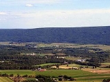
Geography
Washington Township is bordered by Clinton CountyClinton County, Pennsylvania
As of the census of 2000, there were 37,914 people, 14,773 households, and 9,927 families residing in the county. The population density was 43 people per square mile . There were 18,166 housing units at an average density of 20 per square mile...
to the west, Limestone Township to the northwest, Armstrong Township to the north, Brady Township to the northeast, and Union County
Union County, Pennsylvania
-Demographics:As of the census of 2000, there were 41,624 people, 13,178 households, and 9,211 families residing in the county. The population density was 131 people per square mile . There were 14,684 housing units at an average density of 46 per square mile...
to the east and south. As the crow flies
As the crow flies
"As the crow flies" or beelining is an idiom for the shortest route between two points; the geodesic distance.An example is the great-circle distance between Key West and Pensacola, at either end of the U.S...
, Lycoming County is about 130 miles (209 km) northwest of Philadelphia and 165 miles (266 km) east-northeast of Pittsburgh.
According to the United States Census Bureau
United States Census Bureau
The United States Census Bureau is the government agency that is responsible for the United States Census. It also gathers other national demographic and economic data...
, the township has a total area of 48.5 square miles (125.7 km²), all of it land.
Demographics
As of the censusCensus
A census is the procedure of systematically acquiring and recording information about the members of a given population. It is a regularly occurring and official count of a particular population. The term is used mostly in connection with national population and housing censuses; other common...
of 2000, there were 1,613 people, 549 households, and 462 families residing in the township. The population density
Population density
Population density is a measurement of population per unit area or unit volume. It is frequently applied to living organisms, and particularly to humans...
was 33.2 people per square mile (12.8/km²). There were 639 housing units at an average density of 13.2/sq mi (5.1/km²). The racial makeup of the township was 98.57% White, 0.19% African American, 0.37% Native American, 0.12% Asian, 0.12% from other races
Race (United States Census)
Race and ethnicity in the United States Census, as defined by the Federal Office of Management and Budget and the United States Census Bureau, are self-identification data items in which residents choose the race or races with which they most closely identify, and indicate whether or not they are...
, and 0.62% from two or more races. Hispanic or Latino of any race were 0.19% of the population.
Marriage
Marriage is a social union or legal contract between people that creates kinship. It is an institution in which interpersonal relationships, usually intimate and sexual, are acknowledged in a variety of ways, depending on the culture or subculture in which it is found...
living together, 4.7% had a female householder with no husband present, and 15.8% were non-families. 13.1% of all households were made up of individuals and 6.0% had someone living alone who was 65 years of age or older. The average household size was 2.94 and the average family size was 3.21.
In the township the population was spread out with 28.9% under the age of 18, 7.1% from 18 to 24, 28.5% from 25 to 44, 24.5% from 45 to 64, and 11.1% who were 65 years of age or older. The median age was 36 years. For every 100 females there were 108.4 males. For every 100 females age 18 and over, there were 104.5 males.
The median income for a household in the township was $41,739, and the median income for a family was $45,804. Males had a median income of $31,098 versus $22,031 for females. The per capita income
Per capita income
Per capita income or income per person is a measure of mean income within an economic aggregate, such as a country or city. It is calculated by taking a measure of all sources of income in the aggregate and dividing it by the total population...
for the township was $17,124. About 6.5% of families and 10.3% of the population were below the poverty line, including 17.4% of those under age 18 and 4.0% of those age 65 or over.
See also
For histories of the other townships in Lycoming County see- History of the Townships of Lycoming County, PennsylvaniaHistory of the Townships of Lycoming County, PennsylvaniaLycoming County was formed from Northumberland County on April 13, 1795. At the time it was formed the county was much larger than it is today. It took up most of the land that is now north central Pennsylvania....