

Kittanning, Pennsylvania
Encyclopedia
Kittanning is a borough
and the county seat
of Armstrong County
, Pennsylvania
in the United States
. It is situated 44 miles (70.8 km) northeast of Pittsburgh, along the east bank of the Allegheny River
. The name means "at the great stream" in the Delaware
(Native American
) language. The borough and its bridge were used as a setting for several recent films.
 The borough is located on the east bank of the Allegheny River, founded on the site of the eighteenth-century Native American village of Kittanning
at the western end of the Kittanning Path
. In 1756, the village was destroyed by John Armstrong, Sr. at the Battle of Kittanning
during the French and Indian War
. During the attack, a blast from the explosion of gunpowder stored in Captain Jacobs
's house was heard in Pittsburgh, 44 miles away.
Early in the 20th century, it had large iron and steel works, foundries, coal mines, glassworks, flour and lumber mills, china, pottery, brick, lime, and clay works, mirror and typewriter factories, breweries, etc.
In 1900, 3,902 people lived in Kittanning, and in 1910, there were 4,311 inhabitants. After Kittanning merged with Wickboro (1910 population 2,775), in 1914, an estimated 10,000 residents lived in Kittanning in that year. The 1920 census counted 7,153 residents. In 1930, there were 7,808 residents; in 1940, 7,550. The population was 4,787 at the 2000 census. Kittanning is the county seat of Armstrong County.
The playground on North Jefferson Street was formerly the Kittanning Cemetery; 274 graves were moved in 1960 to a new cemetery along Troy Hill Road.
According to the United States Census Bureau
, the borough has a total area of 1 square miles (2.6 km²), all land.
of 2000, there were 4,787 people, 2,032 households, and 1,117 families residing in the borough. The population density
was 4,615.2 people per square mile (1,777.2/km²). There were 2,251 housing units at an average density of 2,170.2 per square mile (835.7/km²). The racial makeup of the borough was 97.31% White, 1.57% African American, 0.23% Native American, 0.25% Asian, 0.08% from other races
, and 0.56% from two or more races. Hispanic or Latino of any race were 0.67% of the population.
There were 2,032 households out of which 26.2% had children under the age of 18 living with them, 36.7% were married couples
living together, 14.9% had a female householder with no husband present, and 45.0% were non-families. 40.5% of all households were made up of individuals and 19.4% had someone living alone who was 65 years of age or older. The average household size was 2.19 and the average family size was 2.96.
In the borough the population was spread out with 22.2% under the age of 18, 10.4% from 18 to 24, 27.1% from 25 to 44, 20.3% from 45 to 64, and 20.1% who were 65 years of age or older. The median age was 40 years. For every 100 females there were 82.5 males. For every 100 females age 18 and over, there were 78.2 males.
The median income for a household in the borough was $20,921, and the median income for a family was $30,822. Males had a median income of $29,036 versus $20,040 for females. The per capita income
for the borough was $13,787. About 12.3% of families and 16.4% of the population were below the poverty line, including 14.8% of those under age 18 and 11.7% of those age 65 or over.
. Both Kittanning Junior High School
(KJHS) and Kittanning Senior High School
(KSHS) are located in the borough.
, which was built higher above ground level to avoid flooding. Scenes with the town and bridge were the used in the film The Mothman Prophecies (2002
) starring Richard Gere
and Laura Linney
, which was filmed in the Kittanning area.
Borough (Pennsylvania)
In the U.S. Commonwealth of Pennsylvania, a borough is a self-governing municipal entity that is usually smaller than a city. There are 958 boroughs in Pennsylvania. All municipalities in Pennsylvania are classified as either cities, boroughs, or townships...
and the county seat
County seat
A county seat is an administrative center, or seat of government, for a county or civil parish. The term is primarily used in the United States....
of Armstrong County
Armstrong County, Pennsylvania
Armstrong County is a county located in the U.S. state of Pennsylvania. As of the 2010 census, the population was 68,941. It is located northeast of Pittsburgh and Allegheny County. Armstrong County was added to the Pittsburgh Metropolitan Statistical Area in 2003.The county seat is Kittanning...
, Pennsylvania
Pennsylvania
The Commonwealth of Pennsylvania is a U.S. state that is located in the Northeastern and Mid-Atlantic regions of the United States. The state borders Delaware and Maryland to the south, West Virginia to the southwest, Ohio to the west, New York and Ontario, Canada, to the north, and New Jersey to...
in the United States
United States
The United States of America is a federal constitutional republic comprising fifty states and a federal district...
. It is situated 44 miles (70.8 km) northeast of Pittsburgh, along the east bank of the Allegheny River
Allegheny River
The Allegheny River is a principal tributary of the Ohio River; it is located in the Eastern United States. The Allegheny River joins with the Monongahela River to form the Ohio River at the "Point" of Point State Park in Downtown Pittsburgh, Pennsylvania...
. The name means "at the great stream" in the Delaware
Lenape
The Lenape are an Algonquian group of Native Americans of the Northeastern Woodlands. They are also called Delaware Indians. As a result of the American Revolutionary War and later Indian removals from the eastern United States, today the main groups live in Canada, where they are enrolled in the...
(Native American
Native Americans in the United States
Native Americans in the United States are the indigenous peoples in North America within the boundaries of the present-day continental United States, parts of Alaska, and the island state of Hawaii. They are composed of numerous, distinct tribes, states, and ethnic groups, many of which survive as...
) language. The borough and its bridge were used as a setting for several recent films.
History
Kittanning (village)
Kittanning was an 18th century Native American village in the Ohio Country, located on the Allegheny River at present-day Kittanning, Pennsylvania. The village was at the western terminus of the Kittanning Path, an Indian trail that provided a route across the Alleghenies between the Ohio and...
at the western end of the Kittanning Path
Kittanning Path
The Kittanning Path was a major east-westNative American trail in western Pennsylvania used during the 18th century. It provided an overland route for the Lenape, Shawnee, and early European settlers across the Allegheny Mountains, terminating at its western end on the Allegheny River at the Native...
. In 1756, the village was destroyed by John Armstrong, Sr. at the Battle of Kittanning
Kittanning Expedition
The Kittanning Expedition, also known as the Armstrong Expedition or the Battle of Kittanning, was a raid during the French and Indian War that led to the destruction of the American Indian village of Kittanning, which had served as a staging point for attacks by Delaware warriors against...
during the French and Indian War
French and Indian War
The French and Indian War is the common American name for the war between Great Britain and France in North America from 1754 to 1763. In 1756, the war erupted into the world-wide conflict known as the Seven Years' War and thus came to be regarded as the North American theater of that war...
. During the attack, a blast from the explosion of gunpowder stored in Captain Jacobs
Captain Jacobs
Captain Jacobs was a Delaware chief during the French and Indian War. His real name was Tewea; he was called "Captain Jacobs" by a Pennsylvania settler who purchased land from him and thought he resembled another person by that name. He is best known as the Native American leader during the...
's house was heard in Pittsburgh, 44 miles away.
Early in the 20th century, it had large iron and steel works, foundries, coal mines, glassworks, flour and lumber mills, china, pottery, brick, lime, and clay works, mirror and typewriter factories, breweries, etc.
In 1900, 3,902 people lived in Kittanning, and in 1910, there were 4,311 inhabitants. After Kittanning merged with Wickboro (1910 population 2,775), in 1914, an estimated 10,000 residents lived in Kittanning in that year. The 1920 census counted 7,153 residents. In 1930, there were 7,808 residents; in 1940, 7,550. The population was 4,787 at the 2000 census. Kittanning is the county seat of Armstrong County.
The playground on North Jefferson Street was formerly the Kittanning Cemetery; 274 graves were moved in 1960 to a new cemetery along Troy Hill Road.
Geography
Kittanning is located at 40°49′12"N 79°31′17"W (40.820085, -79.521398).According to the United States Census Bureau
United States Census Bureau
The United States Census Bureau is the government agency that is responsible for the United States Census. It also gathers other national demographic and economic data...
, the borough has a total area of 1 square miles (2.6 km²), all land.
Demographics
As of the censusCensus
A census is the procedure of systematically acquiring and recording information about the members of a given population. It is a regularly occurring and official count of a particular population. The term is used mostly in connection with national population and housing censuses; other common...
of 2000, there were 4,787 people, 2,032 households, and 1,117 families residing in the borough. The population density
Population density
Population density is a measurement of population per unit area or unit volume. It is frequently applied to living organisms, and particularly to humans...
was 4,615.2 people per square mile (1,777.2/km²). There were 2,251 housing units at an average density of 2,170.2 per square mile (835.7/km²). The racial makeup of the borough was 97.31% White, 1.57% African American, 0.23% Native American, 0.25% Asian, 0.08% from other races
Race (United States Census)
Race and ethnicity in the United States Census, as defined by the Federal Office of Management and Budget and the United States Census Bureau, are self-identification data items in which residents choose the race or races with which they most closely identify, and indicate whether or not they are...
, and 0.56% from two or more races. Hispanic or Latino of any race were 0.67% of the population.
There were 2,032 households out of which 26.2% had children under the age of 18 living with them, 36.7% were married couples
Marriage
Marriage is a social union or legal contract between people that creates kinship. It is an institution in which interpersonal relationships, usually intimate and sexual, are acknowledged in a variety of ways, depending on the culture or subculture in which it is found...
living together, 14.9% had a female householder with no husband present, and 45.0% were non-families. 40.5% of all households were made up of individuals and 19.4% had someone living alone who was 65 years of age or older. The average household size was 2.19 and the average family size was 2.96.
In the borough the population was spread out with 22.2% under the age of 18, 10.4% from 18 to 24, 27.1% from 25 to 44, 20.3% from 45 to 64, and 20.1% who were 65 years of age or older. The median age was 40 years. For every 100 females there were 82.5 males. For every 100 females age 18 and over, there were 78.2 males.
The median income for a household in the borough was $20,921, and the median income for a family was $30,822. Males had a median income of $29,036 versus $20,040 for females. The per capita income
Per capita income
Per capita income or income per person is a measure of mean income within an economic aggregate, such as a country or city. It is calculated by taking a measure of all sources of income in the aggregate and dividing it by the total population...
for the borough was $13,787. About 12.3% of families and 16.4% of the population were below the poverty line, including 14.8% of those under age 18 and 11.7% of those age 65 or over.
Education
All public schools in the Kittanning attendance area are a part of the Armstrong School DistrictArmstrong School District (Pennsylvania)
The Armstrong School District is a large, public school district which encompasses approximately 437 square miles. In Armstrong County, Pennsylvania the district covers the Boroughs of Applewold, Atwood, Dayton, Elderton, Ford City, Ford Cliff, Kittanning, Manorville, Rural Valley, West Kittanning...
. Both Kittanning Junior High School
Kittanning Junior High School
Kittanning Junior High School is a middle school in Kittanning, Pennsylvania within the Armstrong School District. The school serves students in grades 7 and 8 in the Kittanning Attendance Area.-History:...
(KJHS) and Kittanning Senior High School
Kittanning High School
Kittanning Senior High School is a public high school located in Kittanning, Pennsylvania. The school serves grades 9 through 12 as part of the Armstrong School District .Graduation Rate:2009 - 87%2008 - 89%-Academic achievement:...
(KSHS) are located in the borough.
The Mothman Prophecies
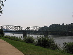
The original bridge over the Allegheny River at Kittanning was torn down and replaced with the Kittanning Citizens BridgeKittanning Citizens Bridge
The Kittanning Citizens Bridge is a through truss bridge spanning the Allegheny River at Kittanning in the U.S. state of Pennsylvania. Constructed in 1932, the bridge carries vehicles and pedestrians between Kittanning and West Kittanning. The bridge was used as a backdrop, and climax scene in...
, which was built higher above ground level to avoid flooding. Scenes with the town and bridge were the used in the film The Mothman Prophecies (2002
2002 in film
The year 2002 in film involved some significant events. The first significant releases of sequels took place between The Lord of the Rings: The Two Towers, Harry Potter and the Chamber of Secrets, Star Wars Episode II: Attack of the Clones, Men in Black II, Analyze That, Spy Kids 2: The Island of...
) starring Richard Gere
Richard Gere
Richard Tiffany Gere is an American actor. He began acting in the 1970s, playing a supporting role in Looking for Mr. Goodbar, and a starring role in Days of Heaven. He came to prominence in 1980 for his role in the film American Gigolo, which established him as a leading man and a sex symbol...
and Laura Linney
Laura Linney
Laura Leggett Linney is an American actress of film, television, and theatre. Linney has won three Emmy Awards, two Golden Globes, and a Screen Actors Guild Award. She has been nominated for three times for an Academy Award and once for a BAFTA Award...
, which was filmed in the Kittanning area.
My Bloody Valentine 3D
Scenes for the horror movie My Bloody Valentine 3D were filmed in Kittanning.Justified
The pilot episode for Justified, starring Timothy Olyphant, was filmed in Kittanning and its surrounding areas.One for the Money
Filming for the movie One for the Money took place during Summer 2010.See also
External links
- Armstrong County Tourist Bureau website
- Carl's Kittaning.com website "since 1997"
- Downtown Kittaning Walking Tour
- Refresh Kittanning
- Kittanning Online - history of Kittanning and social networking site