
List of dams of the United States by height
Encyclopedia

Oroville Dam
Oroville Dam spans the Feather River about northeast of the city of Oroville, California. It forms Lake Oroville, which stores water for irrigation, flood control, municipal water supply and hydroelectricity generation in California's Sacramento Valley. The dam lies in the foothills of the Sierra...
in California
California
California is a state located on the West Coast of the United States. It is by far the most populous U.S. state, and the third-largest by land area...
, 23rd tallest in the world, which stands 770 feet (234.7 m) high along the Feather River
Feather River
The Feather River is the principal tributary of the Sacramento River, in the Sacramento Valley of Northern California. The river's main stem is about long. Its length to its most distant headwater tributary is about . Its drainage basin is about...
. California also has five other dams that are among the ten highest dams in the United States.
Flaming Gorge Dam
The Flaming Gorge Dam is a concrete thin-arch dam in the Flaming Gorge of the Green River, a major tributary of the Colorado River, in the U.S. state of Utah. One of the largest dams in the American West, Flaming Gorge Dam forms the Flaming Gorge Reservoir, which extends into southern Wyoming,...
, Glen Canyon Dam
Glen Canyon Dam
Glen Canyon Dam is a concrete arch dam on the Colorado River in northern Arizona in the United States, just north of Page. The dam was built to provide hydroelectricity and flow regulation from the upper Colorado River Basin to the lower. Its reservoir is called Lake Powell, and is the second...
, and Hoover Dam
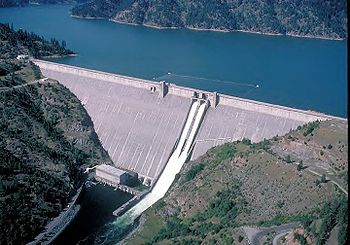
Hoover Dam
Hoover Dam, once known as Boulder Dam, is a concrete arch-gravity dam in the Black Canyon of the Colorado River, on the border between the US states of Arizona and Nevada. It was constructed between 1931 and 1936 during the Great Depression and was dedicated on September 30, 1935, by President...
, are located in the American Southwest where one of the largest canyon systems in the world, the Grand Canyon
Grand Canyon
The Grand Canyon is a steep-sided canyon carved by the Colorado River in the United States in the state of Arizona. It is largely contained within the Grand Canyon National Park, the 15th national park in the United States...
, is found.
Lists mostly follow the same format. The first column gives the dam name, and the second column the height. The next column houses an image. The next three columns give the river it impounds, the state it is located in and the county (or general location). The last three columns list the construction date of the dam, the coordinates, and a short description.
Top 10 Highest Dams in the United States
| Dam | Height | Image | River | Location | Construction Date | Coordinates | Description |
|---|---|---|---|---|---|---|---|
| Oroville Dam Oroville Dam Oroville Dam spans the Feather River about northeast of the city of Oroville, California. It forms Lake Oroville, which stores water for irrigation, flood control, municipal water supply and hydroelectricity generation in California's Sacramento Valley. The dam lies in the foothills of the Sierra... |
770 feet (234.7 m) | Feather River Feather River The Feather River is the principal tributary of the Sacramento River, in the Sacramento Valley of Northern California. The river's main stem is about long. Its length to its most distant headwater tributary is about . Its drainage basin is about... |
Butte County Butte County, California Butte County is a county located in the Central Valley of the US state of California, north of the state capital of Sacramento. As of the 2010 census, it had a population of 220,000. The county seat is Oroville. Butte County is the "Land of Natural Wealth and Beauty."Butte County is watered by the... , California California California is a state located on the West Coast of the United States. It is by far the most populous U.S. state, and the third-largest by land area... |
1967 | 39.5387°N 121.4855°W | Earthfill dam | |
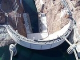
| Hoover Dam Hoover Dam Hoover Dam, once known as Boulder Dam, is a concrete arch-gravity dam in the Black Canyon of the Colorado River, on the border between the US states of Arizona and Nevada. It was constructed between 1931 and 1936 during the Great Depression and was dedicated on September 30, 1935, by President... |
726 feet (221.3 m) | 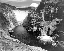 |
Colorado River Colorado River The Colorado River , is a river in the Southwestern United States and northwestern Mexico, approximately long, draining a part of the arid regions on the western slope of the Rocky Mountains. The watershed of the Colorado River covers in parts of seven U.S. states and two Mexican states... |
Mohave County, Arizona Arizona Arizona ; is a state located in the southwestern region of the United States. It is also part of the western United States and the mountain west. The capital and largest city is Phoenix... , and Clark County Clark County, Nevada -Demographics:As of the census of 2000, there were 1,375,765 people, 512,253 households, and 339,693 families residing within the MSA. The racial makeup of the MSA was 71.6% White , 9.1% Black, 5.7% Asian, 0.8% American Indian and 12.8% of other or mixed race. 22.0% were Hispanic of any race... , Nevada Nevada Nevada is a state in the western, mountain west, and southwestern regions of the United States. With an area of and a population of about 2.7 million, it is the 7th-largest and 35th-most populous state. Over two-thirds of Nevada's people live in the Las Vegas metropolitan area, which contains its... |
1938 | 36.0160°N 114.7380°W | Concrete arch dam on Colorado River, tallest in world upon completion in 1938. Forms Lake Mead Lake Mead Lake Mead is the largest reservoir in the United States. It is located on the Colorado River about southeast of Las Vegas, Nevada, in the states of Nevada and Arizona. Formed by water impounded by the Hoover Dam, it extends behind the dam, holding approximately of water.-History:The lake was... which stretches 110 miles (177 km) upstream to the Grand Canyon Grand Canyon The Grand Canyon is a steep-sided canyon carved by the Colorado River in the United States in the state of Arizona. It is largely contained within the Grand Canyon National Park, the 15th national park in the United States... . |
| Dworshak Dam Dworshak Dam Dworshak Dam is a hydroelectric, concrete gravity dam in Clearwater County, Idaho, United States on the North Fork Clearwater River. The dam is located northwest of the city of Orofino, and east of Lewiston. The dam is the highest straight-axis concrete dam in the Western Hemisphere and the 22nd... |
717 feet (218 m) | 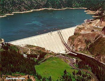 |
Clearwater River Clearwater River (Idaho) The Clearwater River is a river in north central Idaho, which flows westward from the Bitterroot Mountains along the Idaho-Montana border, and joins the Snake River at Lewiston. In October 1805, the Lewis and Clark Expedition descended the Clearwater River in dugout canoes, putting in at "Canoe... |
Clearwater County Clearwater County, Idaho Clearwater County is a county located in the U.S. state of Idaho. Established in 1911, the county was named after the Clearwater River. As of the 2000 Census the county had a population of 8,930 . The county seat is Orofino.... , Idaho Idaho Idaho is a state in the Rocky Mountain area of the United States. The state's largest city and capital is Boise. Residents are called "Idahoans". Idaho was admitted to the Union on July 3, 1890, as the 43rd state.... |
1972 | 46.5149°N 116.2968°W | Concrete gravity dam on Clearwater River Clearwater River (Idaho) The Clearwater River is a river in north central Idaho, which flows westward from the Bitterroot Mountains along the Idaho-Montana border, and joins the Snake River at Lewiston. In October 1805, the Lewis and Clark Expedition descended the Clearwater River in dugout canoes, putting in at "Canoe... in Idaho. Produces 460 MW of power. |
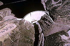
| Glen Canyon Dam Glen Canyon Dam Glen Canyon Dam is a concrete arch dam on the Colorado River in northern Arizona in the United States, just north of Page. The dam was built to provide hydroelectricity and flow regulation from the upper Colorado River Basin to the lower. Its reservoir is called Lake Powell, and is the second... |
710 feet (216 m) | 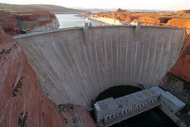 |
Colorado River Colorado River The Colorado River , is a river in the Southwestern United States and northwestern Mexico, approximately long, draining a part of the arid regions on the western slope of the Rocky Mountains. The watershed of the Colorado River covers in parts of seven U.S. states and two Mexican states... |
Coconino County Coconino County, Arizona -2010:Whereas according to the 2010 U.S. Census Bureau:*61.7% White*1.2% Black*27.3% Native American*1.4% Asian*0.1% Native Hawaiian or Pacific Islander*3.1% Two or more races*5.2% Other races*13.5% Hispanic or Latino -2000:... , Arizona Arizona Arizona ; is a state located in the southwestern region of the United States. It is also part of the western United States and the mountain west. The capital and largest city is Phoenix... |
1966 | 36.9374°N 111.4843°W | Concrete arch dam on Colorado River in Glen Canyon Glen Canyon Glen Canyon is a canyon that is located in southeastern and south central Utah and northwestern Arizona within the Vermilion Cliffs area. It was carved by the Colorado River.... . Similar in size to Hoover Dam, one of the most controversial dam projects of all time. |
| New Bullards Bar Dam New Bullards Bar Dam New Bullards Bar Dam is a dam in California on the North Yuba River and forms the New Bullards Bar Reservoir, which has a capacity of . It is located near the town of Dobbins in Yuba County. The dam is operated by the Yuba County Water Agency for irrigation, drinking water and hydroelectric power... |
645 feet (196.6 m) | 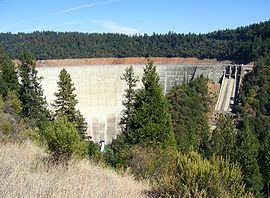 |
Yuba River Yuba River The Yuba River is a tributary of the Feather River in the Sacramento Valley of the U.S. state of California. It is one of the Feather's most important branches, providing about a third of its flow. The main stem of the river is about long, and its headwaters are split into North, Middle and South... |
Yuba County, California California California is a state located on the West Coast of the United States. It is by far the most populous U.S. state, and the third-largest by land area... |
1969 | 39.3921°N 121.1410°W | |
| Seven Oaks Dam Seven Oaks Dam The Seven Oaks Dam is located on the Santa Ana River, 4 miles northeast of Redlands, California. It was constructed by the United States Army Corps of Engineers as a flood control dam. The dam sits virtually on top of the San Andreas Fault and is designed to withstand a magnitude 8.0... |
632 feet (192.6 m) | Santa Ana River Santa Ana River The Santa Ana River is the largest river of Southern California in the United States. Its drainage basin spans four counties. It rises in the San Bernardino Mountains and flows past the cities of San Bernardino and Riverside, before cutting through the northern tip of the Santa Ana Mountains and... |
San Bernardino County, California California California is a state located on the West Coast of the United States. It is by far the most populous U.S. state, and the third-largest by land area... |
1999 | 34.0704°N 117.0552°W | Flood control dam on Santa Ana River. | |
| New Melones Dam New Melones Dam New Melones Dam is an earth and rock filled dam across the Stanislaus River creating New Melones Lake. Situated between Calaveras and Tuolumne County, California in the Sierra Nevada foothills near Jamestown, the dam was completed in 1979 replacing the old Melones Dam.-Background:The dam was... |
625 feet (190.5 m) | 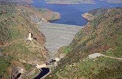 |
Stanislaus River Stanislaus River The Stanislaus River in California is one of the largest tributaries of the San Joaquin River. The river is long and has north, middle and south forks... |
Tuolumne County, California California California is a state located on the West Coast of the United States. It is by far the most populous U.S. state, and the third-largest by land area... |
1979 | 37.9471°N 120.5279°W | |
| Mossyrock Dam Mossyrock Dam Mossyrock Dam is a concrete arch-gravity dam on the Cowlitz River near Mossyrock in Lewis County, Washington. The reservoir created by the dam is called Riffe Lake and the primary purpose of the dam is hydroelectric production while flood control is secondary... |
606 feet (184.7 m) | Cowlitz River Cowlitz River The Cowlitz River is a river in the state of Washington in the United States, a tributary of the Columbia River. Its tributaries drain a large region including the slopes of Mount Rainier, Mount Adams, and Mount St. Helens.... |
Lewis County Lewis County, Washington Lewis County is a county located in the U.S. state of Washington. As of 2010, the population was 75,455. The county seat is at Chehalis, and its largest city is Centralia.... , Washington |
1968 | 46.5345°N 122.4262°W | ||
| Shasta Dam Shasta Dam Shasta Dam is an arch dam across the Sacramento River in the northern part of the U.S. state of California, at the north end of the Sacramento Valley. The dam mainly serves long-term water storage and flood control in its reservoir, Shasta Lake, and also generates hydroelectric power... |
602 feet (183.5 m) | Sacramento River Sacramento River The Sacramento River is an important watercourse of Northern and Central California in the United States. The largest river in California, it rises on the eastern slopes of the Klamath Mountains, and after a journey south of over , empties into Suisun Bay, an arm of the San Francisco Bay, and... |
Shasta County, California California California is a state located on the West Coast of the United States. It is by far the most populous U.S. state, and the third-largest by land area... |
1945 | 40.7184°N 122.4188°W | Concrete arch dam on Sacramento River Sacramento River The Sacramento River is an important watercourse of Northern and Central California in the United States. The largest river in California, it rises on the eastern slopes of the Klamath Mountains, and after a journey south of over , empties into Suisun Bay, an arm of the San Francisco Bay, and... in northern California. Forms Shasta Lake, one of the largest reservoirs in California. |
|
| New Don Pedro Dam New Don Pedro Dam New Don Pedro Dam is built across the Tuolumne River and creates Lake Don Pedro in the foothills of the Sierra Nevada mountain range in the U.S. state of California. The New Don Pedro Dam takes its name from Don Pedros Bar which was named after Pierre "Don Pedro" Sainsevain... |
585 feet (178.3 m) | Tuolumne River Tuolumne River The Tuolumne River is a California river that flows nearly from the central Sierra Nevada to the San Joaquin River in the Central Valley... |
Tuolumne County, California California California is a state located on the West Coast of the United States. It is by far the most populous U.S. state, and the third-largest by land area... |
1971 | 37.7127°N 120.4024°W |
Highest dams by state and region
- Pacific (Washington, OregonOregonOregon is a state in the Pacific Northwest region of the United States. It is located on the Pacific coast, with Washington to the north, California to the south, Nevada on the southeast and Idaho to the east. The Columbia and Snake rivers delineate much of Oregon's northern and eastern...
, CaliforniaCaliforniaCalifornia is a state located on the West Coast of the United States. It is by far the most populous U.S. state, and the third-largest by land area...
, AlaskaAlaskaAlaska is the largest state in the United States by area. It is situated in the northwest extremity of the North American continent, with Canada to the east, the Arctic Ocean to the north, and the Pacific Ocean to the west and south, with Russia further west across the Bering Strait...
, HawaiiHawaiiHawaii is the newest of the 50 U.S. states , and is the only U.S. state made up entirely of islands. It is the northernmost island group in Polynesia, occupying most of an archipelago in the central Pacific Ocean, southwest of the continental United States, southeast of Japan, and northeast of...
) - West (UtahUtahUtah is a state in the Western United States. It was the 45th state to join the Union, on January 4, 1896. Approximately 80% of Utah's 2,763,885 people live along the Wasatch Front, centering on Salt Lake City. This leaves vast expanses of the state nearly uninhabited, making the population the...
, ArizonaArizonaArizona ; is a state located in the southwestern region of the United States. It is also part of the western United States and the mountain west. The capital and largest city is Phoenix...
, New MexicoNew MexicoNew Mexico is a state located in the southwest and western regions of the United States. New Mexico is also usually considered one of the Mountain States. With a population density of 16 per square mile, New Mexico is the sixth-most sparsely inhabited U.S...
, NevadaNevadaNevada is a state in the western, mountain west, and southwestern regions of the United States. With an area of and a population of about 2.7 million, it is the 7th-largest and 35th-most populous state. Over two-thirds of Nevada's people live in the Las Vegas metropolitan area, which contains its...
, IdahoIdahoIdaho is a state in the Rocky Mountain area of the United States. The state's largest city and capital is Boise. Residents are called "Idahoans". Idaho was admitted to the Union on July 3, 1890, as the 43rd state....
, MontanaMontanaMontana is a state in the Western United States. The western third of Montana contains numerous mountain ranges. Smaller, "island ranges" are found in the central third of the state, for a total of 77 named ranges of the Rocky Mountains. This geographical fact is reflected in the state's name,...
, WyomingWyomingWyoming is a state in the mountain region of the Western United States. The western two thirds of the state is covered mostly with the mountain ranges and rangelands in the foothills of the Eastern Rocky Mountains, while the eastern third of the state is high elevation prairie known as the High...
, North DakotaNorth DakotaNorth Dakota is a state located in the Midwestern region of the United States of America, along the Canadian border. The state is bordered by Canada to the north, Minnesota to the east, South Dakota to the south and Montana to the west. North Dakota is the 19th-largest state by area in the U.S....
, OklahomaOklahomaOklahoma is a state located in the South Central region of the United States of America. With an estimated 3,751,351 residents as of the 2010 census and a land area of 68,667 square miles , Oklahoma is the 28th most populous and 20th-largest state...
, South DakotaSouth DakotaSouth Dakota is a state located in the Midwestern region of the United States. It is named after the Lakota and Dakota Sioux American Indian tribes. Once a part of Dakota Territory, South Dakota became a state on November 2, 1889. The state has an area of and an estimated population of just over...
, TexasTexasTexas is the second largest U.S. state by both area and population, and the largest state by area in the contiguous United States.The name, based on the Caddo word "Tejas" meaning "friends" or "allies", was applied by the Spanish to the Caddo themselves and to the region of their settlement in...
) - Midwest (WisconsinWisconsinWisconsin is a U.S. state located in the north-central United States and is part of the Midwest. It is bordered by Minnesota to the west, Iowa to the southwest, Illinois to the south, Lake Michigan to the east, Michigan to the northeast, and Lake Superior to the north. Wisconsin's capital is...
, MichiganMichiganMichigan is a U.S. state located in the Great Lakes Region of the United States of America. The name Michigan is the French form of the Ojibwa word mishigamaa, meaning "large water" or "large lake"....
, MissouriMissouriMissouri is a US state located in the Midwestern United States, bordered by Iowa, Illinois, Kentucky, Tennessee, Arkansas, Oklahoma, Kansas and Nebraska. With a 2010 population of 5,988,927, Missouri is the 18th most populous state in the nation and the fifth most populous in the Midwest. It...
, KansasKansasKansas is a US state located in the Midwestern United States. It is named after the Kansas River which flows through it, which in turn was named after the Kansa Native American tribe, which inhabited the area. The tribe's name is often said to mean "people of the wind" or "people of the south...
, MississippiMississippiMississippi is a U.S. state located in the Southern United States. Jackson is the state capital and largest city. The name of the state derives from the Mississippi River, which flows along its western boundary, whose name comes from the Ojibwe word misi-ziibi...
, AlabamaAlabamaAlabama is a state located in the southeastern region of the United States. It is bordered by Tennessee to the north, Georgia to the east, Florida and the Gulf of Mexico to the south, and Mississippi to the west. Alabama ranks 30th in total land area and ranks second in the size of its inland...
, LouisianaLouisianaLouisiana is a state located in the southern region of the United States of America. Its capital is Baton Rouge and largest city is New Orleans. Louisiana is the only state in the U.S. with political subdivisions termed parishes, which are local governments equivalent to counties...
, IllinoisIllinoisIllinois is the fifth-most populous state of the United States of America, and is often noted for being a microcosm of the entire country. With Chicago in the northeast, small industrial cities and great agricultural productivity in central and northern Illinois, and natural resources like coal,...
, IndianaIndianaIndiana is a US state, admitted to the United States as the 19th on December 11, 1816. It is located in the Midwestern United States and Great Lakes Region. With 6,483,802 residents, the state is ranked 15th in population and 16th in population density. Indiana is ranked 38th in land area and is...
, KentuckyKentuckyThe Commonwealth of Kentucky is a state located in the East Central United States of America. As classified by the United States Census Bureau, Kentucky is a Southern state, more specifically in the East South Central region. Kentucky is one of four U.S. states constituted as a commonwealth...
, TennesseeTennesseeTennessee is a U.S. state located in the Southeastern United States. It has a population of 6,346,105, making it the nation's 17th-largest state by population, and covers , making it the 36th-largest by total land area... - Southeast (GeorgiaGeorgia (U.S. state)Georgia is a state located in the southeastern United States. It was established in 1732, the last of the original Thirteen Colonies. The state is named after King George II of Great Britain. Georgia was the fourth state to ratify the United States Constitution, on January 2, 1788...
, FloridaFloridaFlorida is a state in the southeastern United States, located on the nation's Atlantic and Gulf coasts. It is bordered to the west by the Gulf of Mexico, to the north by Alabama and Georgia and to the east by the Atlantic Ocean. With a population of 18,801,310 as measured by the 2010 census, it...
, South CarolinaSouth CarolinaSouth Carolina is a state in the Deep South of the United States that borders Georgia to the south, North Carolina to the north, and the Atlantic Ocean to the east. Originally part of the Province of Carolina, the Province of South Carolina was one of the 13 colonies that declared independence...
, North CarolinaNorth CarolinaNorth Carolina is a state located in the southeastern United States. The state borders South Carolina and Georgia to the south, Tennessee to the west and Virginia to the north. North Carolina contains 100 counties. Its capital is Raleigh, and its largest city is Charlotte...
) - Northeast (VirginiaVirginiaThe Commonwealth of Virginia , is a U.S. state on the Atlantic Coast of the Southern United States. Virginia is nicknamed the "Old Dominion" and sometimes the "Mother of Presidents" after the eight U.S. presidents born there...
, West VirginiaWest VirginiaWest Virginia is a state in the Appalachian and Southeastern regions of the United States, bordered by Virginia to the southeast, Kentucky to the southwest, Ohio to the northwest, Pennsylvania to the northeast and Maryland to the east...
, PennsylvaniaPennsylvaniaThe Commonwealth of Pennsylvania is a U.S. state that is located in the Northeastern and Mid-Atlantic regions of the United States. The state borders Delaware and Maryland to the south, West Virginia to the southwest, Ohio to the west, New York and Ontario, Canada, to the north, and New Jersey to...
, DelawareDelawareDelaware is a U.S. state located on the Atlantic Coast in the Mid-Atlantic region of the United States. It is bordered to the south and west by Maryland, and to the north by Pennsylvania...
, MarylandMarylandMaryland is a U.S. state located in the Mid Atlantic region of the United States, bordering Virginia, West Virginia, and the District of Columbia to its south and west; Pennsylvania to its north; and Delaware to its east...
, ConnecticutConnecticutConnecticut is a state in the New England region of the northeastern United States. It is bordered by Rhode Island to the east, Massachusetts to the north, and the state of New York to the west and the south .Connecticut is named for the Connecticut River, the major U.S. river that approximately...
, MassachusettsMassachusettsThe Commonwealth of Massachusetts is a state in the New England region of the northeastern United States of America. It is bordered by Rhode Island and Connecticut to the south, New York to the west, and Vermont and New Hampshire to the north; at its east lies the Atlantic Ocean. As of the 2010...
, Rhode IslandRhode IslandThe state of Rhode Island and Providence Plantations, more commonly referred to as Rhode Island , is a state in the New England region of the United States. It is the smallest U.S. state by area...
, New YorkNew YorkNew York is a state in the Northeastern region of the United States. It is the nation's third most populous state. New York is bordered by New Jersey and Pennsylvania to the south, and by Connecticut, Massachusetts and Vermont to the east...
, New JerseyNew JerseyNew Jersey is a state in the Northeastern and Middle Atlantic regions of the United States. , its population was 8,791,894. It is bordered on the north and east by the state of New York, on the southeast and south by the Atlantic Ocean, on the west by Pennsylvania and on the southwest by Delaware...
, VermontVermontVermont is a state in the New England region of the northeastern United States of America. The state ranks 43rd in land area, , and 45th in total area. Its population according to the 2010 census, 630,337, is the second smallest in the country, larger only than Wyoming. It is the only New England...
, New HampshireNew HampshireNew Hampshire is a state in the New England region of the northeastern United States of America. The state was named after the southern English county of Hampshire. It is bordered by Massachusetts to the south, Vermont to the west, Maine and the Atlantic Ocean to the east, and the Canadian...
, MaineMaineMaine is a state in the New England region of the northeastern United States, bordered by the Atlantic Ocean to the east and south, New Hampshire to the west, and the Canadian provinces of Quebec to the northwest and New Brunswick to the northeast. Maine is both the northernmost and easternmost...
)
Pacific
| Dam | Height | River | State(s) | County(s) or location | Construction Date | Coordinates |
|---|---|---|---|---|---|---|
| Oroville Dam Oroville Dam Oroville Dam spans the Feather River about northeast of the city of Oroville, California. It forms Lake Oroville, which stores water for irrigation, flood control, municipal water supply and hydroelectricity generation in California's Sacramento Valley. The dam lies in the foothills of the Sierra... |
770 feet (234.7 m) | Feather River Feather River The Feather River is the principal tributary of the Sacramento River, in the Sacramento Valley of Northern California. The river's main stem is about long. Its length to its most distant headwater tributary is about . Its drainage basin is about... |
California California California is a state located on the West Coast of the United States. It is by far the most populous U.S. state, and the third-largest by land area... |
Butte County Butte County, California Butte County is a county located in the Central Valley of the US state of California, north of the state capital of Sacramento. As of the 2010 census, it had a population of 220,000. The county seat is Oroville. Butte County is the "Land of Natural Wealth and Beauty."Butte County is watered by the... |
1967 | 39.5387°N 121.4855°W |
| New Don Pedro Dam New Don Pedro Dam New Don Pedro Dam is built across the Tuolumne River and creates Lake Don Pedro in the foothills of the Sierra Nevada mountain range in the U.S. state of California. The New Don Pedro Dam takes its name from Don Pedros Bar which was named after Pierre "Don Pedro" Sainsevain... |
585 feet (178.3 m) | Tuolumne River Tuolumne River The Tuolumne River is a California river that flows nearly from the central Sierra Nevada to the San Joaquin River in the Central Valley... |
California California California is a state located on the West Coast of the United States. It is by far the most populous U.S. state, and the third-largest by land area... |
Tuolumne County, | 1971 | 37.7127°N 120.4024°W |
| Seven Oaks Dam Seven Oaks Dam The Seven Oaks Dam is located on the Santa Ana River, 4 miles northeast of Redlands, California. It was constructed by the United States Army Corps of Engineers as a flood control dam. The dam sits virtually on top of the San Andreas Fault and is designed to withstand a magnitude 8.0... |
550 feet (167.6 m) | Santa Ana River Santa Ana River The Santa Ana River is the largest river of Southern California in the United States. Its drainage basin spans four counties. It rises in the San Bernardino Mountains and flows past the cities of San Bernardino and Riverside, before cutting through the northern tip of the Santa Ana Mountains and... |
California California California is a state located on the West Coast of the United States. It is by far the most populous U.S. state, and the third-largest by land area... |
San Bernardino County | 1999 | 34.0704°N 117.0552°W |
| Grand Coulee Dam Grand Coulee Dam Grand Coulee Dam is a gravity dam on the Columbia River in the U.S. state of Washington built to produce hydroelectric power and provide irrigation. It was constructed between 1933 and 1942, originally with two power plants. A third power station was completed in 1974 to increase its energy... |
550 feet (167.6 m) | Columbia River Columbia River The Columbia River is the largest river in the Pacific Northwest region of North America. The river rises in the Rocky Mountains of British Columbia, Canada, flows northwest and then south into the U.S. state of Washington, then turns west to form most of the border between Washington and the state... |
Washington | Grant/Okanogan County | 1942 | 47.955833°N 118.981667°W |
| Mossyrock Dam Mossyrock Dam Mossyrock Dam is a concrete arch-gravity dam on the Cowlitz River near Mossyrock in Lewis County, Washington. The reservoir created by the dam is called Riffe Lake and the primary purpose of the dam is hydroelectric production while flood control is secondary... |
606 feet (184.7 m) | Cowlitz River Cowlitz River The Cowlitz River is a river in the state of Washington in the United States, a tributary of the Columbia River. Its tributaries drain a large region including the slopes of Mount Rainier, Mount Adams, and Mount St. Helens.... |
Washington | Lewis Lewis County, Washington Lewis County is a county located in the U.S. state of Washington. As of 2010, the population was 75,455. The county seat is at Chehalis, and its largest city is Centralia.... |
1968 | 46.5345°N 122.4262°W |
| Cougar Dam Cougar Dam Cougar Dam is a tall rockfill hydroelectric dam in the U.S. state of Oregon. It has a gated concrete spillway and a powerhouse with two turbines totaling 25 megawatts of electric power.... |
519 feet (158.2 m) | Mckenzie River McKenzie River The McKenzie River is a tributary of the Willamette River in western Oregon in the United States. It drains part of the Cascade Range east of Eugene and flows into the southernmost end of the Willamette Valley. It is named for Donald MacKenzie, a Scottish Canadian fur trader... South Fork |
Oregon Oregon Oregon is a state in the Pacific Northwest region of the United States. It is located on the Pacific coast, with Washington to the north, California to the south, Nevada on the southeast and Idaho to the east. The Columbia and Snake rivers delineate much of Oregon's northern and eastern... |
1964 | 44.1290°N 122.2403°W | |
| Oroville Dam Oroville Dam Oroville Dam spans the Feather River about northeast of the city of Oroville, California. It forms Lake Oroville, which stores water for irrigation, flood control, municipal water supply and hydroelectricity generation in California's Sacramento Valley. The dam lies in the foothills of the Sierra... |
770 feet (234.7 m) | Feather River Feather River The Feather River is the principal tributary of the Sacramento River, in the Sacramento Valley of Northern California. The river's main stem is about long. Its length to its most distant headwater tributary is about . Its drainage basin is about... |
California California California is a state located on the West Coast of the United States. It is by far the most populous U.S. state, and the third-largest by land area... |
Butte Butte County, California Butte County is a county located in the Central Valley of the US state of California, north of the state capital of Sacramento. As of the 2010 census, it had a population of 220,000. The county seat is Oroville. Butte County is the "Land of Natural Wealth and Beauty."Butte County is watered by the... |
1967 | 39.5387°N 121.4855°W |
| Blue Lake Dam Blue Lake (Alaska) Blue Lake, or Gajook Héen Yik.áayi, in the Tlingit language, is a long reservoir located east of the town of Sitka, on the west side of Baranof Island, in Alexander Archipelago of Southeast Alaska.-History:... |
342 feet (104.2 m) | Blue Lake Valley Creek | Alaska Alaska Alaska is the largest state in the United States by area. It is situated in the northwest extremity of the North American continent, with Canada to the east, the Arctic Ocean to the north, and the Pacific Ocean to the west and south, with Russia further west across the Bering Strait... |
Sitka | 1958 | 57.0616°N 135.1988°W |
West
| Dam | Height | River | State(s) | County(s) or location | Construction Date | Coordinates |
|---|---|---|---|---|---|---|
| Flaming Gorge Dam Flaming Gorge Dam The Flaming Gorge Dam is a concrete thin-arch dam in the Flaming Gorge of the Green River, a major tributary of the Colorado River, in the U.S. state of Utah. One of the largest dams in the American West, Flaming Gorge Dam forms the Flaming Gorge Reservoir, which extends into southern Wyoming,... |
502 feet (153 m) | Green River Green River (Utah) The Green River, located in the western United States, is the chief tributary of the Colorado River. The watershed of the river, known as the Green River Basin, covers parts of Wyoming, Utah, and Colorado. The Green River is long, beginning in the Wind River Mountains of Wyoming and flowing... |
Utah Utah Utah is a state in the Western United States. It was the 45th state to join the Union, on January 4, 1896. Approximately 80% of Utah's 2,763,885 people live along the Wasatch Front, centering on Salt Lake City. This leaves vast expanses of the state nearly uninhabited, making the population the... |
Daggett | 1968 | 40.9144°N 109.4215°W |
| Hoover Dam Hoover Dam Hoover Dam, once known as Boulder Dam, is a concrete arch-gravity dam in the Black Canyon of the Colorado River, on the border between the US states of Arizona and Nevada. It was constructed between 1931 and 1936 during the Great Depression and was dedicated on September 30, 1935, by President... |
726 feet (221.3 m) | Colorado River Colorado River The Colorado River , is a river in the Southwestern United States and northwestern Mexico, approximately long, draining a part of the arid regions on the western slope of the Rocky Mountains. The watershed of the Colorado River covers in parts of seven U.S. states and two Mexican states... |
Arizona Arizona Arizona ; is a state located in the southwestern region of the United States. It is also part of the western United States and the mountain west. The capital and largest city is Phoenix... , Nevada Nevada Nevada is a state in the western, mountain west, and southwestern regions of the United States. With an area of and a population of about 2.7 million, it is the 7th-largest and 35th-most populous state. Over two-thirds of Nevada's people live in the Las Vegas metropolitan area, which contains its... |
Mohave, Clark Clark County, Nevada -Demographics:As of the census of 2000, there were 1,375,765 people, 512,253 households, and 339,693 families residing within the MSA. The racial makeup of the MSA was 71.6% White , 9.1% Black, 5.7% Asian, 0.8% American Indian and 12.8% of other or mixed race. 22.0% were Hispanic of any race... |
1938 | 36.0160°N 114.7380°W |
| Navajo Dam Navajo Dam Navajo Dam is an earthen dam on the San Juan River, a tributary of the Colorado River, in northwestern New Mexico in the United States. The dam and its reservoir, Navajo Lake, lie in the arid western foothills of the Rocky Mountains about east of Farmington.... |
402 feet (122.5 m) | San Juan River | New Mexico New Mexico New Mexico is a state located in the southwest and western regions of the United States. New Mexico is also usually considered one of the Mountain States. With a population density of 16 per square mile, New Mexico is the sixth-most sparsely inhabited U.S... |
1962 | ||
| Dworshak Dam Dworshak Dam Dworshak Dam is a hydroelectric, concrete gravity dam in Clearwater County, Idaho, United States on the North Fork Clearwater River. The dam is located northwest of the city of Orofino, and east of Lewiston. The dam is the highest straight-axis concrete dam in the Western Hemisphere and the 22nd... |
717 feet (218.5 m) | Clearwater River Clearwater River (Idaho) The Clearwater River is a river in north central Idaho, which flows westward from the Bitterroot Mountains along the Idaho-Montana border, and joins the Snake River at Lewiston. In October 1805, the Lewis and Clark Expedition descended the Clearwater River in dugout canoes, putting in at "Canoe... |
Idaho Idaho Idaho is a state in the Rocky Mountain area of the United States. The state's largest city and capital is Boise. Residents are called "Idahoans". Idaho was admitted to the Union on July 3, 1890, as the 43rd state.... |
Clearwater Clearwater County, Idaho Clearwater County is a county located in the U.S. state of Idaho. Established in 1911, the county was named after the Clearwater River. As of the 2000 Census the county had a population of 8,930 . The county seat is Orofino.... |
1972 | 46.5149°N 116.2968°W |
| Yellowtail Dam Yellowtail Dam Yellowtail Dam is a dam across the Bighorn River in southwestern Montana in the United States. The mid-1960s era concrete arch dam serves to regulate the flow of the Bighorn for irrigation purposes and to generate hydroelectric power. The dam and its reservoir, Bighorn Lake, are owned by the U.S... |
525 feet (160 m) | Big Horn River | Montana Montana Montana is a state in the Western United States. The western third of Montana contains numerous mountain ranges. Smaller, "island ranges" are found in the central third of the state, for a total of 77 named ranges of the Rocky Mountains. This geographical fact is reflected in the state's name,... |
1968 | 45.3066°N 107.9581°W | |
| Buffalo Bill Dam Buffalo Bill Dam Buffalo Bill Dam is a concrete arch-gravity dam on the Shoshone River in the U.S. state of Wyoming. The dam is named after the famous old West figure William "Buffalo Bill" Cody who founded the nearby town of Cody and who owned much of the land now covered by the reservoir formed by the dam, which... |
353 feet (107.6 m) | Shoshone River Shoshone River The Shoshone River is long river in northern Wyoming in the United States. Its headwaters are in the Absaroka Range in Shoshone National Forest. It ends when it runs into the Big Horn River near Lovell, Wyoming. Cities it runs near or through are Cody, Powell, Byron, and Lovell. Near Cody, it... |
Wyoming Wyoming Wyoming is a state in the mountain region of the Western United States. The western two thirds of the state is covered mostly with the mountain ranges and rangelands in the foothills of the Eastern Rocky Mountains, while the eastern third of the state is high elevation prairie known as the High... |
Park | 1910 | 44.5016°N 109.1840°W |
| Hungry Horse Dam Hungry Horse Dam Hungry Horse Dam is an arch dam on the South Fork Flathead River in the Rocky Mountains of the U.S. state of Montana. It is located in Flathead National Forest, in Flathead County, about south of the west entrance to Glacier National Park, southeast of Columbia Falls, and northeast of Kalispell... |
564 feet (171.9 m) | South Fork Flathead River South Fork Flathead River The South Fork Flathead River is a major river in Northwestern Montana in the northwest United States. It is one of the three main forks of the Flathead River, a tributary of the Clark Fork River... |
Montana Montana Montana is a state in the Western United States. The western third of Montana contains numerous mountain ranges. Smaller, "island ranges" are found in the central third of the state, for a total of 77 named ranges of the Rocky Mountains. This geographical fact is reflected in the state's name,... |
Glacier National Park | 1953 | 48.3413°N 114.0131°W |
| Broken Bow Broken Bow Lake Broken Bow Lake is a reservoir in southeast Oklahoma, located on Mountain Fork River and north of the town of Broken Bow. It is one of the largest lakes within the state of Oklahoma, and a popular tourist destination for locals and visitors from neighboring Texas.The lake stretches... Dam |
225 feet (68.6 m) | Mountain Fork Mountain Fork Mountain Fork, also known as the Mountain Fork of the Little River, is a tributary of the Little River in western Arkansas and southeastern Oklahoma in the United States... |
Oklahoma Oklahoma Oklahoma is a state located in the South Central region of the United States of America. With an estimated 3,751,351 residents as of the 2010 census and a land area of 68,667 square miles , Oklahoma is the 28th most populous and 20th-largest state... |
McCurtain | 1970 |
Midwest
| Dam | Height | River | State(s) | County(s) or location | Construction Date | Coordinates |
|---|---|---|---|---|---|---|
| Wisconsin Wisconsin Wisconsin is a U.S. state located in the north-central United States and is part of the Midwest. It is bordered by Minnesota to the west, Iowa to the southwest, Illinois to the south, Lake Michigan to the east, Michigan to the northeast, and Lake Superior to the north. Wisconsin's capital is... |
||||||
| Michigan Michigan Michigan is a U.S. state located in the Great Lakes Region of the United States of America. The name Michigan is the French form of the Ojibwa word mishigamaa, meaning "large water" or "large lake".... |
||||||
| Missouri Missouri Missouri is a US state located in the Midwestern United States, bordered by Iowa, Illinois, Kentucky, Tennessee, Arkansas, Oklahoma, Kansas and Nebraska. With a 2010 population of 5,988,927, Missouri is the 18th most populous state in the nation and the fifth most populous in the Midwest. It... |
||||||
| Kansas Kansas Kansas is a US state located in the Midwestern United States. It is named after the Kansas River which flows through it, which in turn was named after the Kansa Native American tribe, which inhabited the area. The tribe's name is often said to mean "people of the wind" or "people of the south... |
||||||
| Mississippi Mississippi Mississippi is a U.S. state located in the Southern United States. Jackson is the state capital and largest city. The name of the state derives from the Mississippi River, which flows along its western boundary, whose name comes from the Ojibwe word misi-ziibi... |
||||||
| Alabama Alabama Alabama is a state located in the southeastern region of the United States. It is bordered by Tennessee to the north, Georgia to the east, Florida and the Gulf of Mexico to the south, and Mississippi to the west. Alabama ranks 30th in total land area and ranks second in the size of its inland... |
||||||
| Toledo Bend Dam Toledo Bend Reservoir Toledo Bend Reservoir is a reservoir on the Sabine River between Texas and Louisiana. The lake has an area of 185,000 acres , the largest man-made body of water in Texas, the largest in the South, and the fifth largest in the United States. The dam is capable of generating 92 megawatts of... |
110 feet (33.5 m) | Sabine River Sabine River (Texas-Louisiana) The Sabine River is a river, long, in the U.S. states of Texas and Louisiana. In its lower course, it forms part of the boundary between the two states and empties into Sabine Lake, an estuary of the Gulf of Mexico. The river formed part of the United States-Mexican international boundary during... |
Louisiana Louisiana Louisiana is a state located in the southern region of the United States of America. Its capital is Baton Rouge and largest city is New Orleans. Louisiana is the only state in the U.S. with political subdivisions termed parishes, which are local governments equivalent to counties... |
1969 | 39.1965°N 93.5721°W | |
| Illinois Illinois Illinois is the fifth-most populous state of the United States of America, and is often noted for being a microcosm of the entire country. With Chicago in the northeast, small industrial cities and great agricultural productivity in central and northern Illinois, and natural resources like coal,... |
||||||
| Indiana Indiana Indiana is a US state, admitted to the United States as the 19th on December 11, 1816. It is located in the Midwestern United States and Great Lakes Region. With 6,483,802 residents, the state is ranked 15th in population and 16th in population density. Indiana is ranked 38th in land area and is... |
||||||
| Kentucky Kentucky The Commonwealth of Kentucky is a state located in the East Central United States of America. As classified by the United States Census Bureau, Kentucky is a Southern state, more specifically in the East South Central region. Kentucky is one of four U.S. states constituted as a commonwealth... |
||||||
| Fontana Dam Fontana Dam Fontana Dam is a hydroelectric dam on the Little Tennessee River in Swain and Graham counties, North Carolina, USA. The dam is operated by the Tennessee Valley Authority, which built the dam in the early 1940s to accommodate the skyrocketing electricity demands in the Tennessee Valley at the... |
480 feet (146.3 m) | Little Tennessee River Little Tennessee River The Little Tennessee River is a tributary of the Tennessee River, approximately 135 miles long, in the Appalachian Mountains in the southeastern United States.-Geography:... |
Tennessee Tennessee Tennessee is a U.S. state located in the Southeastern United States. It has a population of 6,346,105, making it the nation's 17th-largest state by population, and covers , making it the 36th-largest by total land area... |
Appalachian Mountains Appalachian Mountains The Appalachian Mountains #Whether the stressed vowel is or ,#Whether the "ch" is pronounced as a fricative or an affricate , and#Whether the final vowel is the monophthong or the diphthong .), often called the Appalachians, are a system of mountains in eastern North America. The Appalachians... |
1944 | 35°27′08"N 83°48′17"W |
Southeast
| Dam | Height | River | State(s) | County(s) or location | Construction Date | Coordinates |
|---|---|---|---|---|---|---|
| Carters Dam Carters Dam Carters Dam is an earthen embankment dam located south of Chatsworth in Murray County and west of Ellijay in the U.S. state of Georgia. The dam is 445 ft tall and is situated above the mouth of the Coosawattee River. The drainage area is 376 square miles .The dam took 15 years to build... |
445 feet (135.6 m) | Coosawattee River Coosawattee River The Coosawattee River is a river located in the northwest part of the U.S. state of Georgia.The river begins at the confluence of the Ellijay River and Cartecay River in the city of Ellijay in Gilmer County. The river flows west through the foothills of the north Georgia mountains.In Murray... |
Georgia Georgia (U.S. state) Georgia is a state located in the southeastern United States. It was established in 1732, the last of the original Thirteen Colonies. The state is named after King George II of Great Britain. Georgia was the fourth state to ratify the United States Constitution, on January 2, 1788... |
Murray Murray County, Georgia Murray County is a county located in the U.S. state of Georgia. As of 2000, the population was 36,506. The 2007 Census Estimate showed a population of 40,664. The county seat is Chatsworth.It is part of the Dalton, Georgia, Metropolitan Statistical Area.... |
1977 | 34.6131°N 84.6707°W |
| Florida Florida Florida is a state in the southeastern United States, located on the nation's Atlantic and Gulf coasts. It is bordered to the west by the Gulf of Mexico, to the north by Alabama and Georgia and to the east by the Atlantic Ocean. With a population of 18,801,310 as measured by the 2010 census, it... |
||||||
| South Carolina South Carolina South Carolina is a state in the Deep South of the United States that borders Georgia to the south, North Carolina to the north, and the Atlantic Ocean to the east. Originally part of the Province of Carolina, the Province of South Carolina was one of the 13 colonies that declared independence... |
||||||
| Fontana Dam Fontana Dam Fontana Dam is a hydroelectric dam on the Little Tennessee River in Swain and Graham counties, North Carolina, USA. The dam is operated by the Tennessee Valley Authority, which built the dam in the early 1940s to accommodate the skyrocketing electricity demands in the Tennessee Valley at the... |
480 feet (146.3 m) | Little Tennessee River Little Tennessee River The Little Tennessee River is a tributary of the Tennessee River, approximately 135 miles long, in the Appalachian Mountains in the southeastern United States.-Geography:... |
North Carolina North Carolina North Carolina is a state located in the southeastern United States. The state borders South Carolina and Georgia to the south, Tennessee to the west and Virginia to the north. North Carolina contains 100 counties. Its capital is Raleigh, and its largest city is Charlotte... |
Swain | 1944 | 35.4523°N 83.8048°W |
Northeast
| Dam | Height | River | State(s) | County(s) or location | Construction Date | Coordinates |
|---|---|---|---|---|---|---|
| Smith Mountain Dam Smith Mountain Dam Smith Mountain Dam is concrete arch dam located on the Roanoke River in Virginia, creating Smith Mountain Lake. The dam was built by Appalachian Power between 1960 and 1963 for the purposes of hydroelectricity via pumped-storage hydroelectricity... |
227 feet (69.2 m) | Roanoke River Roanoke River The Roanoke River is a river in southern Virginia and northeastern North Carolina in the United States, 410 mi long. A major river of the southeastern United States, it drains a largely rural area of the coastal plain from the eastern edge of the Appalachian Mountains southeast across the Piedmont... |
Virginia Virginia The Commonwealth of Virginia , is a U.S. state on the Atlantic Coast of the Southern United States. Virginia is nicknamed the "Old Dominion" and sometimes the "Mother of Presidents" after the eight U.S. presidents born there... |
Franklin Franklin County, Virginia As of the census of 2000, there were 47,286 people, 18,963 households, and 13,918 families residing in the county. The population density was 68 people per square mile . There were 22,717 housing units at an average density of 33 per square mile... , Bedford Bedford County, Virginia As of the census of 2000, there were 60,371 people, 23,838 households, and 18,164 families residing in the county. The population density was 80 people per square mile . There were 26,841 housing units at an average density of 36 per square mile... , Roanoke Roanoke County, Virginia Roanoke County is a county located in the U.S. state of the Commonwealth of Virginia. It is part of the Roanoke Metropolitan Statistical Area and located within the Roanoke Region of Virginia. As of the 2000 census, the population was 85,778. As of 2010, the population was 92,376... , Pittsylvania Pittsylvania County, Virginia As of the census of 2000, there were 61,745 people, 24,684 households, and 18,216 families residing in the county. The population density was 64 people per square mile . There were 28,011 housing units at an average density of 29 per square mile... |
1963 | 37.0228°N 79.3208°W |
| Philpott Dam Philpott Dam Philpott Dam is a concrete, gravity dam on the Smith River in Franklin and Henry counties in the U.S. state of Virginia. It impounds Philpott Lake.Philpott Dam is located about 44 river miles above the mouth of the Smith River... |
220 feet (67.1 m) | Smith River Smith River (Virginia) The Smith River is a river in the U.S. states of Virginia and North Carolina. It is a tributary of the Dan River, which it joins at Eden, North Carolina... |
Virginia Virginia The Commonwealth of Virginia , is a U.S. state on the Atlantic Coast of the Southern United States. Virginia is nicknamed the "Old Dominion" and sometimes the "Mother of Presidents" after the eight U.S. presidents born there... |
Franklin Franklin County, Virginia As of the census of 2000, there were 47,286 people, 18,963 households, and 13,918 families residing in the county. The population density was 68 people per square mile . There were 22,717 housing units at an average density of 33 per square mile... , Henry Henry County, Virginia As of the census of 2000, there were 57,930 people, 23,910 households, and 16,952 families residing in the county. The population density was 152 people per square mile . There were 25,921 housing units at an average density of 68 per square mile... |
1953 | 36.7812°N 80.0275°W |
| West Virginia West Virginia West Virginia is a state in the Appalachian and Southeastern regions of the United States, bordered by Virginia to the southeast, Kentucky to the southwest, Ohio to the northwest, Pennsylvania to the northeast and Maryland to the east... |
||||||
| Kinzua Dam Kinzua Dam The Kinzua Dam, in the Allegheny National Forest in Warren County, Pennsylvania, is one of the largest dams in the United States east of the Mississippi River.... |
175 feet (53.3 m) | Allegheny River Allegheny River The Allegheny River is a principal tributary of the Ohio River; it is located in the Eastern United States. The Allegheny River joins with the Monongahela River to form the Ohio River at the "Point" of Point State Park in Downtown Pittsburgh, Pennsylvania... |
Pennsylvania Pennsylvania The Commonwealth of Pennsylvania is a U.S. state that is located in the Northeastern and Mid-Atlantic regions of the United States. The state borders Delaware and Maryland to the south, West Virginia to the southwest, Ohio to the west, New York and Ontario, Canada, to the north, and New Jersey to... |
Warren Warren County, Pennsylvania Warren County is a county located in the U.S. state of Pennsylvania. As of 2010, the population was 41,815. It was formed in 1800 from parts of Allegheny and Lycoming counties; attached to Crawford County until 1805 and then to Venango County until Warren was formally organized in 1819. Its county... |
1965 | 41.8378°N 79.0039°W |
| Delaware Delaware Delaware is a U.S. state located on the Atlantic Coast in the Mid-Atlantic region of the United States. It is bordered to the south and west by Maryland, and to the north by Pennsylvania... |
||||||
| Maryland Maryland Maryland is a U.S. state located in the Mid Atlantic region of the United States, bordering Virginia, West Virginia, and the District of Columbia to its south and west; Pennsylvania to its north; and Delaware to its east... |
||||||
| Connecticut Connecticut Connecticut is a state in the New England region of the northeastern United States. It is bordered by Rhode Island to the east, Massachusetts to the north, and the state of New York to the west and the south .Connecticut is named for the Connecticut River, the major U.S. river that approximately... |
||||||
| Massachusetts Massachusetts The Commonwealth of Massachusetts is a state in the New England region of the northeastern United States of America. It is bordered by Rhode Island and Connecticut to the south, New York to the west, and Vermont and New Hampshire to the north; at its east lies the Atlantic Ocean. As of the 2010... |
||||||
| Rhode Island Rhode Island The state of Rhode Island and Providence Plantations, more commonly referred to as Rhode Island , is a state in the New England region of the United States. It is the smallest U.S. state by area... |
||||||
| New Croton Dam New Croton Dam The New Croton Dam, part of the New York City water supply system, stretches across the Croton River near Croton-on-Hudson, New York, about north of New York City. Construction began in 1892 and was completed in 1906. Designed by Alphonse Fteley , this masonry dam is broad at its base and high... |
297 feet (90.5 m) | New York New York New York is a state in the Northeastern region of the United States. It is the nation's third most populous state. New York is bordered by New Jersey and Pennsylvania to the south, and by Connecticut, Massachusetts and Vermont to the east... |
||||
| Merril Creek Dam | 280 feet (85.3 m) | New Jersey New Jersey New Jersey is a state in the Northeastern and Middle Atlantic regions of the United States. , its population was 8,791,894. It is bordered on the north and east by the state of New York, on the southeast and south by the Atlantic Ocean, on the west by Pennsylvania and on the southwest by Delaware... |
||||
| Ball Mountain Dam | 265 feet (80.8 m) | Vermont Vermont Vermont is a state in the New England region of the northeastern United States of America. The state ranks 43rd in land area, , and 45th in total area. Its population according to the 2010 census, 630,337, is the second smallest in the country, larger only than Wyoming. It is the only New England... |
43°07′39"N 72°46′26"W | |||
| New Hampshire New Hampshire New Hampshire is a state in the New England region of the northeastern United States of America. The state was named after the southern English county of Hampshire. It is bordered by Massachusetts to the south, Vermont to the west, Maine and the Atlantic Ocean to the east, and the Canadian... |
||||||
| Maine Maine Maine is a state in the New England region of the northeastern United States, bordered by the Atlantic Ocean to the east and south, New Hampshire to the west, and the Canadian provinces of Quebec to the northwest and New Brunswick to the northeast. Maine is both the northernmost and easternmost... |
External links
- 10 Highest Dams in the United States (Archived 2009-10-31)
- U