
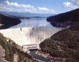
Hungry Horse Dam
Encyclopedia
Hungry Horse Dam is an arch dam
on the South Fork Flathead River
in the Rocky Mountains
of the U.S. state
of Montana
. It is located in Flathead National Forest
, in Flathead County
, about 15 miles (24.1 km) south of the west entrance to Glacier National Park, 9 miles (14.5 km) southeast of Columbia Falls
, and 20 miles (32.2 km) northeast of Kalispell
. The Hungry Horse project, dam, and powerplant are operated by the United States Bureau of Reclamation
.
, Clark Fork
, Pend Oreille River
, and Columbia River
. About a billion kilowatt–hours are generated annually at Hungry Horse Dam, while in an average year the release water will generate about 4.6 billion kilowatt–hours of power as it passes through the series of downstream powerplants.
Power generating facilities at Hungry Horse Dam are housed in a building constructed across the river channel at the downstream toe of the dam. The original design included four 71,250-kilowatt generators—a total of 285 megawatts installed capacity. The generator capacity was uprated in the 1990s to 107,000 kilowatts each for a total capacity of 428 megawatts.
Arch dam
An arch dam is a type of dam that is curved and commonly built with concrete. The arch dam is a structure that is designed to curve upstream so that the force of the water against it, known as hydrostatic pressure, presses against the arch, compressing and strengthening the structure as it pushes...
on the South Fork Flathead River
South Fork Flathead River
The South Fork Flathead River is a major river in Northwestern Montana in the northwest United States. It is one of the three main forks of the Flathead River, a tributary of the Clark Fork River...
in the Rocky Mountains
Rocky Mountains
The Rocky Mountains are a major mountain range in western North America. The Rocky Mountains stretch more than from the northernmost part of British Columbia, in western Canada, to New Mexico, in the southwestern United States...
of the U.S. state
U.S. state
A U.S. state is any one of the 50 federated states of the United States of America that share sovereignty with the federal government. Because of this shared sovereignty, an American is a citizen both of the federal entity and of his or her state of domicile. Four states use the official title of...
of Montana
Montana
Montana is a state in the Western United States. The western third of Montana contains numerous mountain ranges. Smaller, "island ranges" are found in the central third of the state, for a total of 77 named ranges of the Rocky Mountains. This geographical fact is reflected in the state's name,...
. It is located in Flathead National Forest
Flathead National Forest
The Flathead National Forest is a national forest in the western part of the U.S. state of Montana. The forest covers of which about 1 million acres is designated wilderness. It is named after the Flathead Indians who lived in the area. The forest is located in the Rocky Mountains with elevations...
, in Flathead County
Flathead County, Montana
-National protected areas:* Pacific Northwest National Scenic Trail * Flathead National Forest * Glacier National Park * Kootenai National Forest * Lolo National Forest * Lost Trail National Wildlife Refuge-Demographics:...
, about 15 miles (24.1 km) south of the west entrance to Glacier National Park, 9 miles (14.5 km) southeast of Columbia Falls
Columbia Falls, Montana
Columbia Falls is a city in Flathead County, Montana, United States. The population was 3,645 at the 2000 census.-Geography:Columbia Falls is located at ....
, and 20 miles (32.2 km) northeast of Kalispell
Kalispell, Montana
Kalispell is a city in and the county seat of Flathead County, Montana, United States. The 2010 census put Kalispell's population at 19,927 up 5,704 over 2000. At 40.1% this is the largest percentage of growth of any incorporated city in Montana. Kalispell is the largest city and commercial center...
. The Hungry Horse project, dam, and powerplant are operated by the United States Bureau of Reclamation
United States Bureau of Reclamation
The United States Bureau of Reclamation , and formerly the United States Reclamation Service , is an agency under the U.S...
.
Dimensions and statistics
At 564 feet (171.9 m) in height, the dam was the third largest dam, and second highest concrete dam, in the world at the time of its completion in 1953, with a volume of 3100000 cuyd. The dam's spillway is the highest morning glory structure in the world. The spillway is controlled by a 64 by ring gate.History
Construction of Hungry Horse Dam was authorized by the Act of June 5, 1944 (58 Stat. 270, Public Law 78-329). Construction begain in April 1948 and completed in July 16, 1953. The purposes of the Hungry Horse Project authorized by law are irrigation, flood control, navigation, streamflow regulation, hydroelectric generation, and other beneficial uses such as recreation. However, no irrigation facilities were built and the project has no irrigation obligations. Hydroelectric power generation is the primary purpose of the dam today. Flood control is the dam's other main purpose. The dam, reservoir, and surrounding area are used for recreation.Hydroelectric power generation
The project contributes to hydroelectric power generation not only at Hungry Horse Dam, but by storing and releasing water for use by downriver hydroelectric dams on the Flathead RiverFlathead River
The Flathead River, in the northwestern part of the U.S. state of Montana, originates in the Rocky Mountains near Glacier National Park and flows southwest into Flathead Lake, then after a journey of , empties into the Clark Fork. The river is part of the Columbia River drainage basin, as the Clark...
, Clark Fork
Clark Fork (river)
The Clark Fork is a river in the U.S. states of Montana and Idaho, approximately long. The largest river by volume in Montana, it drains an extensive region of the Rocky Mountains in western Montana and northern Idaho in the watershed of the Columbia River, flowing northwest through a long...
, Pend Oreille River
Pend Oreille River
The Pend Oreille River is a tributary of the Columbia River, approximately long, in northern Idaho and northeastern Washington in the United States, as well as southeastern British Columbia in Canada. In its passage through British Columbia its name is spelled Pend-d'Oreille River...
, and Columbia River
Columbia River
The Columbia River is the largest river in the Pacific Northwest region of North America. The river rises in the Rocky Mountains of British Columbia, Canada, flows northwest and then south into the U.S. state of Washington, then turns west to form most of the border between Washington and the state...
. About a billion kilowatt–hours are generated annually at Hungry Horse Dam, while in an average year the release water will generate about 4.6 billion kilowatt–hours of power as it passes through the series of downstream powerplants.
Power generating facilities at Hungry Horse Dam are housed in a building constructed across the river channel at the downstream toe of the dam. The original design included four 71,250-kilowatt generators—a total of 285 megawatts installed capacity. The generator capacity was uprated in the 1990s to 107,000 kilowatts each for a total capacity of 428 megawatts.