
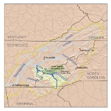
Little Tennessee River
Encyclopedia
The Little Tennessee River is a tributary of the Tennessee River
, approximately 135 miles (217 km) long, in the Appalachian Mountains
in the southeastern
United States
.
, in the Chattahoochee National Forest in northeast Georgia
's Rabun County
. After flowing north through the mountains past Dillard
into southwestern North Carolina
, it is joined by the Cullasaja River
at Franklin, then turns northwest, flowing through the Nantahala National Forest
along the north side of the Nantahala Mountains and past Lauada. It crosses into eastern Tennessee
and joins the Tennessee River
at Lenoir City
, 25 miles (40 km) southwest of Knoxville
.
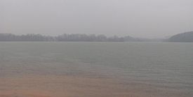
(TVA) system, forming a string of reservoirs in western North Carolina and eastern Tennessee down to its confluence with the Tennessee. Near the state line between North Carolina and Tennessee, it is impounded by the 480 feet (146 m) high Fontana Dam
, completed in 1944, forming Fontana Lake
along the southern boundary of Great Smoky Mountains National Park
. It is also impounded by Cheoah Dam
in North Carolina, and by Calderwood
and Chilhowee
dams in Tennessee. The reservoirs provide flood
control and hydroelectric power.
Calderwood and Cheoah Dams divert water through short tunnels slightly downstream of the dams themselves to hydroelectric generators. Chilhowee
has power generators built straight into the dam itself. Some water is also diverted from the nearby Santeetlah Dam
on the Cheoah River
to power another hydroelectric generator at the Santeetlah Powerhouse. This water is brought to the Little Tennessee River through 7 miles (11 km) of tunnels through the Great Smoky Mountains
. Chilhowee, Calderwood, and Cheoah Dams and the Santeetlah Powerhouse were originally built by Alcoa
to power the aluminum plant at Alcoa, Tennessee
. To ensure efficiency in operation, Alcoa coordinates the operation of its hydro system with TVA, making sure that reservoir and river water levels are safe for recreational use (primarily boating and fishing) and that proper flows of water continue down the river.
The final impoundment is Tellico Dam
, which is just above its mouth into the Tennessee River at Lenoir City, Tennessee
. It creates Tellico Reservoir
. The dam does not have its own hydroelectric generators but serves to increase the flow through those at nearby Fort Loudoun Dam
on the Tennessee by means of a canal
which diverts much of the flow of the Little Tennessee. The plan to build the dam was the subject of environmental controversy
during the 1970s regarding the snail darter
, an endangered species
. It was the first major legal challenge to the Endangered Species Act
.
The Little Tennessee River and its immediate watershed comprise one of the richest archaeological areas in the southeastern United States, containing substantial habitation sites dating back to as early as 7,500 B.C. Cyrus Thomas, who conducted a mound survey in the area for the Smithsonian Institution
in the 1880s, wrote that the Little Tennessee River was "undoubtedly the most interesting archaeological section in the entire Appalachian district."
Substantial Archaic period (8000-1000 B.C.) sites along the river include the Icehouse Bottom site and the Rose Island site, both located near the river's confluence with the Tellico River
. These sites were probably semi-permanent base camps, the inhabitants of which may have sought the chert
deposits on the bluffs above the river which they used to create tools.
Evidence of Woodland period
(1000 B.C. - 1000 A.D.) habitation has been uncovered at numerous sites along the Little Tennessee, most notably at Icehouse Bottom, Rose Island, Calloway Island (near the river's confluence with Toqua Creek), Thirty Acre Island (near the river's confluence with Nine Mile Creek) and Bacon Bend (between Toqua and Citico Beach). Excavations in the 1970s uncovered large Woodland-period burials on Rose Island and Calloway Island. Pottery fragments uncovered at Icehouse Bottom in the 1970s show evidence of interaction with the Hopewell people
of what is now Ohio.
Mississippian period
(c. 1000-1500 A.D.) sites in the Little Tennessee Valley include the Toqua site
(at the river's confluence with Toqua Creek), Tomotley
(adjacent to Toqua), Citico
(at the river's Citico Creek confluence), and Bussell Island
(at the mouth of the river). Toqua's Mississippian inhabitants constructed a 25 feet (7.6 m) platform mound overlooking a central plaza. By 1400, the village covered 4.8 acre (0.019424928 km²) surrounded by a clay-covered palisade.
 Several Cherokee
Middle towns, including Nikwasi
, Jore, and Cowee were located along the river's North Carolina section. The river was also home to most of the major Overhill Cherokee
towns, the most prominent of which included Chota
, Tanasi
, Toqua, Tomotley, Mialoquo
(near Rose Island), Chilhowee
(at the river's Abrams Creek confluence), Tallassee
(near modern Calderwood), Citico, and Tuskegee (adjacent to Fort Loudoun
).
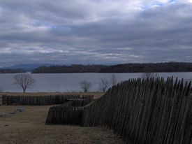
Euro-American traders were visiting the Overhill towns along the Little Tennessee by the late 17th century, and there is some evidence that Hernando De Soto
and Juan Pardo
passed through the Little Tennessee Valley in 1540 and 1567, respectively. In 1756 the English built Fort Loudoun, located at the river's confluence with the Tellico River. The fort has been reconstructed as an historic site. Two early American sites are located along the Little Tennessee— the Tellico Blockhouse
, an outpost at the river's Nine Mile Creek confluence, and Morganton
, a river port and ferry
town near modern Greenback
that thrived in the early 19th century. The Hazel Creek
section of the Great Smoky Mountains National Park, located on the north shore of the river's Fontana Lake impoundment, was home to a substantial Appalachian community in the late 19th and early 20th centuries.
Tennessee River
The Tennessee River is the largest tributary of the Ohio River. It is approximately 652 miles long and is located in the southeastern United States in the Tennessee Valley. The river was once popularly known as the Cherokee River, among other names...
, approximately 135 miles (217 km) long, in the Appalachian Mountains
Appalachian Mountains
The Appalachian Mountains #Whether the stressed vowel is or ,#Whether the "ch" is pronounced as a fricative or an affricate , and#Whether the final vowel is the monophthong or the diphthong .), often called the Appalachians, are a system of mountains in eastern North America. The Appalachians...
in the southeastern
Southeastern United States
The Southeastern United States, colloquially referred to as the Southeast, is the eastern portion of the Southern United States. It is one of the most populous regions in the United States of America....
United States
United States
The United States of America is a federal constitutional republic comprising fifty states and a federal district...
.
Geography
The Little Tennessee River rises in the Blue Ridge MountainsBlue Ridge Mountains
The Blue Ridge Mountains are a physiographic province of the larger Appalachian Mountains range. This province consists of northern and southern physiographic regions, which divide near the Roanoke River gap. The mountain range is located in the eastern United States, starting at its southern-most...
, in the Chattahoochee National Forest in northeast Georgia
Georgia (U.S. state)
Georgia is a state located in the southeastern United States. It was established in 1732, the last of the original Thirteen Colonies. The state is named after King George II of Great Britain. Georgia was the fourth state to ratify the United States Constitution, on January 2, 1788...
's Rabun County
Rabun County, Georgia
Rabun County is a county located in the U.S. state of Georgia. As of the 2000 census, the population was 15,050. The 2007 Census Estimate shows a population of 16,519...
. After flowing north through the mountains past Dillard
Dillard, Georgia
Dillard is a city in Rabun County, Georgia, United States. census, the city population was 198.-Geography:Dillard is located at .According to the United States Census Bureau, Dillard has a total area of , all of it land...
into southwestern North Carolina
North Carolina
North Carolina is a state located in the southeastern United States. The state borders South Carolina and Georgia to the south, Tennessee to the west and Virginia to the north. North Carolina contains 100 counties. Its capital is Raleigh, and its largest city is Charlotte...
, it is joined by the Cullasaja River
Cullasaja River
The Cullasaja River is a short river located entirely in Macon County, North Carolina. It is a tributary of the Little Tennessee River , into which it flows near the county seat of Franklin. It originates to the southeast, near Highlands, the county's only other town...
at Franklin, then turns northwest, flowing through the Nantahala National Forest
Nantahala National Forest
The Nantahala National Forest, established in 1920, is a national forest located in the American state of North Carolina. The word "Nantahala" is a Cherokee word meaning "Land of the Noonday Sun." The name is appropriate as, in some spots, the sun only reaches the floors of the deep gorges of the...
along the north side of the Nantahala Mountains and past Lauada. It crosses into eastern Tennessee
Tennessee
Tennessee is a U.S. state located in the Southeastern United States. It has a population of 6,346,105, making it the nation's 17th-largest state by population, and covers , making it the 36th-largest by total land area...
and joins the Tennessee River
Tennessee River
The Tennessee River is the largest tributary of the Ohio River. It is approximately 652 miles long and is located in the southeastern United States in the Tennessee Valley. The river was once popularly known as the Cherokee River, among other names...
at Lenoir City
Lenoir City, Tennessee
Lenoir City is a city in Loudon County, Tennessee, United States. Its population was 8,642 at the 2010 census. It is included in the Knoxville Metropolitan Area....
, 25 miles (40 km) southwest of Knoxville
Knoxville, Tennessee
Founded in 1786, Knoxville is the third-largest city in the U.S. state of Tennessee, U.S.A., behind Memphis and Nashville, and is the county seat of Knox County. It is the largest city in East Tennessee, and the second-largest city in the Appalachia region...
.
Impoundments
The lower river is impounded several places by sequential dams, some created as part of the Tennessee Valley AuthorityTennessee Valley Authority
The Tennessee Valley Authority is a federally owned corporation in the United States created by congressional charter in May 1933 to provide navigation, flood control, electricity generation, fertilizer manufacturing, and economic development in the Tennessee Valley, a region particularly affected...
(TVA) system, forming a string of reservoirs in western North Carolina and eastern Tennessee down to its confluence with the Tennessee. Near the state line between North Carolina and Tennessee, it is impounded by the 480 feet (146 m) high Fontana Dam
Fontana Dam
Fontana Dam is a hydroelectric dam on the Little Tennessee River in Swain and Graham counties, North Carolina, USA. The dam is operated by the Tennessee Valley Authority, which built the dam in the early 1940s to accommodate the skyrocketing electricity demands in the Tennessee Valley at the...
, completed in 1944, forming Fontana Lake
Fontana Lake
Fontana Lake is a reservoir impounded by Fontana Dam on the Little Tennessee River located in Graham and Swain counties in North Carolina. The lake forms part of the southern border of Great Smoky Mountains National Park and the northern border of part of the Nantahala National Forest. Depending on...
along the southern boundary of Great Smoky Mountains National Park
Great Smoky Mountains National Park
Great Smoky Mountains National Park is a United States National Park and UNESCO World Heritage Site that straddles the ridgeline of the Great Smoky Mountains, part of the Blue Ridge Mountains, which are a division of the larger Appalachian Mountain chain. The border between Tennessee and North...
. It is also impounded by Cheoah Dam
Cheoah Dam
The Cheoah Dam is a hydroelectric complex located in Graham and Swain counties, North Carolina on the Little Tennessee River between river miles 51 and 52. The Cheoah Development consists of a dam and powerhouse, the first of several constructed by the Tallassee Power Company, now Tapoco...
in North Carolina, and by Calderwood
Calderwood Dam
Calderwood Dam is a hydroelectric dam located along the Little Tennessee River in Blount and Monroe counties, Tennessee. Completed in 1930, the dam is owned and maintained by Tapoco, a subsidiary of the Aluminum Company of America , although the Tennessee Valley Authority controls the dam's...
and Chilhowee
Chilhowee Dam
Chilhowee Dam is a hydroelectric dam located in Blount and Monroe counties, Tennessee, between river mile 33 and 34 on the Little Tennessee River. Construction began in 1955 and was completed in 1957. The dam's reservoir covers approximately at normal full pool and has a drainage area of . The...
dams in Tennessee. The reservoirs provide flood
Flood
A flood is an overflow of an expanse of water that submerges land. The EU Floods directive defines a flood as a temporary covering by water of land not normally covered by water...
control and hydroelectric power.
Calderwood and Cheoah Dams divert water through short tunnels slightly downstream of the dams themselves to hydroelectric generators. Chilhowee
Calderwood Dam
Calderwood Dam is a hydroelectric dam located along the Little Tennessee River in Blount and Monroe counties, Tennessee. Completed in 1930, the dam is owned and maintained by Tapoco, a subsidiary of the Aluminum Company of America , although the Tennessee Valley Authority controls the dam's...
has power generators built straight into the dam itself. Some water is also diverted from the nearby Santeetlah Dam
Santeetlah Dam
Santeetlah Dam is a hydroelectric development on the Cheoah River in Graham County, North Carolina. The dam together with a pipeline/tunnel facility, and a powerhouse form the Santeetlah Development...
on the Cheoah River
Cheoah River
The Cheoah River is a tributary of the Little Tennessee River in North Carolina in the United States.It is located in Graham County in far western North Carolina, near Robbinsville, and is approximately 20 miles in length...
to power another hydroelectric generator at the Santeetlah Powerhouse. This water is brought to the Little Tennessee River through 7 miles (11 km) of tunnels through the Great Smoky Mountains
Great Smoky Mountains
The Great Smoky Mountains are a mountain range rising along the Tennessee–North Carolina border in the southeastern United States. They are a subrange of the Appalachian Mountains, and form part of the Blue Ridge Physiographic Province. The range is sometimes called the Smoky Mountains or the...
. Chilhowee, Calderwood, and Cheoah Dams and the Santeetlah Powerhouse were originally built by Alcoa
Alcoa
Alcoa Inc. is the world's third largest producer of aluminum, behind Rio Tinto Alcan and Rusal. From its operational headquarters in Pittsburgh, Pennsylvania, Alcoa conducts operations in 31 countries...
to power the aluminum plant at Alcoa, Tennessee
Alcoa, Tennessee
Alcoa is a city in Blount County, Tennessee, United States, south of Knoxville. Its population was 7,744 at the 2000 census. It is part of the Knoxville, Tennessee Metropolitan Statistical Area....
. To ensure efficiency in operation, Alcoa coordinates the operation of its hydro system with TVA, making sure that reservoir and river water levels are safe for recreational use (primarily boating and fishing) and that proper flows of water continue down the river.
The final impoundment is Tellico Dam
Tellico Dam
Tellico Dam is a dam built by the Tennessee Valley Authority in Loudon County, Tennessee on the Little Tennessee River just above the main stem of the Tennessee River. It impounds the Tellico Reservoir....
, which is just above its mouth into the Tennessee River at Lenoir City, Tennessee
Lenoir City, Tennessee
Lenoir City is a city in Loudon County, Tennessee, United States. Its population was 8,642 at the 2010 census. It is included in the Knoxville Metropolitan Area....
. It creates Tellico Reservoir
Tellico Reservoir
Tellico Reservoir, also known as Tellico Lake, is a reservoir in Tennessee, created by the Tennessee Valley Authority in 1979 upon the completion of Tellico Dam. The dam impounds the Little Tennessee River and the lower Tellico River...
. The dam does not have its own hydroelectric generators but serves to increase the flow through those at nearby Fort Loudoun Dam
Fort Loudoun Dam
Fort Loudoun Dam is a hydroelectric dam on the Tennessee River in Loudon County, Tennessee, in the southeastern United States. The dam is operated by the Tennessee Valley Authority , which built the dam in the early 1940s as part of a unified plan to provide electricity and flood control in the...
on the Tennessee by means of a canal
Canal
Canals are man-made channels for water. There are two types of canal:#Waterways: navigable transportation canals used for carrying ships and boats shipping goods and conveying people, further subdivided into two kinds:...
which diverts much of the flow of the Little Tennessee. The plan to build the dam was the subject of environmental controversy
Snail darter controversy
The snail darter controversy involved the delay of the construction of the Tellico Dam on the Little Tennessee River in 1973. On August 12, 1973, University of Tennessee biologist and professor David Etnier discovered the snail darter in the Little Tennessee River while doing research related to a...
during the 1970s regarding the snail darter
Snail darter
The snail darter is a small , rare fish found in the waters of East Tennessee. It is a variety of darter which feeds primarily on aquatic snails....
, an endangered species
Endangered species
An endangered species is a population of organisms which is at risk of becoming extinct because it is either few in numbers, or threatened by changing environmental or predation parameters...
. It was the first major legal challenge to the Endangered Species Act
Endangered Species Act
The Endangered Species Act of 1973 is one of the dozens of United States environmental laws passed in the 1970s. Signed into law by President Richard Nixon on December 28, 1973, it was designed to protect critically imperiled species from extinction as a "consequence of economic growth and...
.
Prehistoric sites
The Little Tennessee River and its immediate watershed comprise one of the richest archaeological areas in the southeastern United States, containing substantial habitation sites dating back to as early as 7,500 B.C. Cyrus Thomas, who conducted a mound survey in the area for the Smithsonian Institution
Smithsonian Institution
The Smithsonian Institution is an educational and research institute and associated museum complex, administered and funded by the government of the United States and by funds from its endowment, contributions, and profits from its retail operations, concessions, licensing activities, and magazines...
in the 1880s, wrote that the Little Tennessee River was "undoubtedly the most interesting archaeological section in the entire Appalachian district."
Substantial Archaic period (8000-1000 B.C.) sites along the river include the Icehouse Bottom site and the Rose Island site, both located near the river's confluence with the Tellico River
Tellico River
The Tellico River rises in the westernmost mountains of North Carolina, but it flows mainly through Monroe County, Tennessee. It is a major tributary of the Little Tennessee River and the namesake of Tellico Reservoir, a reservoir created by Tellico Dam, which impounds the lower reaches of the...
. These sites were probably semi-permanent base camps, the inhabitants of which may have sought the chert
Chert
Chert is a fine-grained silica-rich microcrystalline, cryptocrystalline or microfibrous sedimentary rock that may contain small fossils. It varies greatly in color , but most often manifests as gray, brown, grayish brown and light green to rusty red; its color is an expression of trace elements...
deposits on the bluffs above the river which they used to create tools.
Evidence of Woodland period
Woodland period
The Woodland period of North American pre-Columbian cultures was from roughly 1000 BCE to 1000 CE in the eastern part of North America. The term "Woodland Period" was introduced in the 1930s as a generic header for prehistoric sites falling between the Archaic hunter-gatherers and the...
(1000 B.C. - 1000 A.D.) habitation has been uncovered at numerous sites along the Little Tennessee, most notably at Icehouse Bottom, Rose Island, Calloway Island (near the river's confluence with Toqua Creek), Thirty Acre Island (near the river's confluence with Nine Mile Creek) and Bacon Bend (between Toqua and Citico Beach). Excavations in the 1970s uncovered large Woodland-period burials on Rose Island and Calloway Island. Pottery fragments uncovered at Icehouse Bottom in the 1970s show evidence of interaction with the Hopewell people
Hopewell culture
The Hopewell tradition is the term used to describe common aspects of the Native American culture that flourished along rivers in the northeastern and midwestern United States from 200 BCE to 500 CE. The Hopewell tradition was not a single culture or society, but a widely dispersed set of related...
of what is now Ohio.
Mississippian period
Mississippian culture
The Mississippian culture was a mound-building Native American culture that flourished in what is now the Midwestern, Eastern, and Southeastern United States from approximately 800 CE to 1500 CE, varying regionally....
(c. 1000-1500 A.D.) sites in the Little Tennessee Valley include the Toqua site
Toqua (Tennessee)
Toqua is a prehistoric and historic Native American site in Monroe County, Tennessee, located in the southeastern United States. Along with the Overhill Cherokee village for which the site was named, Toqua was home to a substantial pre-Cherokee town that thrived during the Mississippian period...
(at the river's confluence with Toqua Creek), Tomotley
Tomotley
Tomotley is a prehistoric and historic Native American site in Monroe County, Tennessee, in the southeastern United States. Occupied as early as the Archaic period, the Tomotley site had the most substantial periods of habitation during the Mississippian period, likely when the earthwork mounds...
(adjacent to Toqua), Citico
Citico (Tellico archaeological site)
Citico is a prehistoric and historic Native American site in Monroe County, Tennessee, in the southeastern United States. The site's namesake Cherokee village was the largest of the Overhill towns, housing an estimated population of 1,000 by the mid-18th century...
(at the river's Citico Creek confluence), and Bussell Island
Bussell Island
Bussell Island, formerly Lenoir Island, is an island located at the mouth of the Little Tennessee River near the U.S. city of Lenoir City, Tennessee. The island was inhabited by various Native American cultures for thousands of years before the arrival of early European explorers, and is currently...
(at the mouth of the river). Toqua's Mississippian inhabitants constructed a 25 feet (7.6 m) platform mound overlooking a central plaza. By 1400, the village covered 4.8 acre (0.019424928 km²) surrounded by a clay-covered palisade.
Historic sites
Cherokee
The Cherokee are a Native American people historically settled in the Southeastern United States . Linguistically, they are part of the Iroquoian language family...
Middle towns, including Nikwasi
Nikwasi
Nikwasi was an important Cherokee town located on the Little Tennessee River at the site of present-day Franklin, North Carolina....
, Jore, and Cowee were located along the river's North Carolina section. The river was also home to most of the major Overhill Cherokee
Overhill Cherokee
The term Overhill Cherokee refers to the former Cherokee settlements located in what is now Tennessee in the southeastern United States. The name was given by 18th century European traders and explorers who had to cross the Appalachian Mountains to reach these settlements when traveling from...
towns, the most prominent of which included Chota
Chota (Cherokee town)
Chota is a historic Overhill Cherokee site in Monroe County, Tennessee, in the southeastern United States. For much of its history, Chota was the most important of the Overhill towns, serving as the de facto capital of the Cherokee people from the late 1740s until 1788...
, Tanasi
Tanasi
Tanasi is a historic Overhill Cherokee village site in Monroe County, Tennessee, in the southeastern United States. The village is best known as the namesake for the state of Tennessee...
, Toqua, Tomotley, Mialoquo
Mialoquo
Mialoquo is a prehistoric and historic Native American site in Monroe County, Tennessee, in the southeastern United States. The site saw significant periods of occupation during the Mississippian period and later as a Cherokee refugee village...
(near Rose Island), Chilhowee
Chilhowee (Cherokee town)
Chilhowee was a prehistoric and historic Native American site in Blount County and Monroe County, Tennessee, in the southeastern United States...
(at the river's Abrams Creek confluence), Tallassee
Tallassee (Cherokee town)
Tallassee is a prehistoric and historic Native American site in Blount County and Monroe County, Tennessee, in the southeastern United States. Tallassee was the southernmost of a string of Overhill Cherokee villages that spanned the lower Little Tennessee River in the 18th century...
(near modern Calderwood), Citico, and Tuskegee (adjacent to Fort Loudoun
Fort Loudoun (Tennessee)
Fort Loudoun was a British colonial fort in present-day Monroe County, Tennessee, near the towns of the Overhill Cherokee. The fort was reconstructed during the Great Depression and was designated a National Historic Landmark in 1965.-History:...
).
Euro-American traders were visiting the Overhill towns along the Little Tennessee by the late 17th century, and there is some evidence that Hernando De Soto
Hernando de Soto (explorer)
Hernando de Soto was a Spanish explorer and conquistador who, while leading the first European expedition deep into the territory of the modern-day United States, was the first European documented to have crossed the Mississippi River....
and Juan Pardo
Juan Pardo (explorer)
Juan Pardo was a Spanish explorer and conquistador who was active in the later half of the sixteenth century. He led a Spanish expedition through what is now North and South Carolina and into eastern Tennessee. He established Fort San Felipe, South Carolina , and the village of Santa Elena on...
passed through the Little Tennessee Valley in 1540 and 1567, respectively. In 1756 the English built Fort Loudoun, located at the river's confluence with the Tellico River. The fort has been reconstructed as an historic site. Two early American sites are located along the Little Tennessee— the Tellico Blockhouse
Tellico Blockhouse
The Tellico Blockhouse was an early American outpost located along the Little Tennessee River in Vonore, Monroe County, Tennessee. Completed in 1794, the blockhouse operated until 1807 with the purpose of keeping the peace between nearby Overhill Cherokee towns and early Euro-American settlers in...
, an outpost at the river's Nine Mile Creek confluence, and Morganton
Morganton, Tennessee
Morganton was a community once located in Loudon County, Tennessee, in the southeastern United States. Although now submerged by Tellico Lake, during its heyday in the 19th century Morganton thrived as a flatboat port and regional business center...
, a river port and ferry
Ferry
A ferry is a form of transportation, usually a boat, but sometimes a ship, used to carry primarily passengers, and sometimes vehicles and cargo as well, across a body of water. Most ferries operate on regular, frequent, return services...
town near modern Greenback
Greenback, Tennessee
Greenback is a city in Loudon County, Tennessee, United States. Its population was at 1,064, according to the 2010 census. It is included in the Knoxville, Tennessee Metropolitan Statistical Area.-Geography:Greenback is located at...
that thrived in the early 19th century. The Hazel Creek
Hazel Creek (Great Smoky Mountains)
Hazel Creek is a tributary stream of the Little Tennessee River in the southwestern Great Smoky Mountains of North Carolina. The creek's bottomlands were home to several pioneer Appalachian communities and logging towns before its incorporation into the Great Smoky Mountains National Park...
section of the Great Smoky Mountains National Park, located on the north shore of the river's Fontana Lake impoundment, was home to a substantial Appalachian community in the late 19th and early 20th centuries.