
Shoshone River
Encyclopedia
The Shoshone River is 100 miles (160.9 km) long river in northern Wyoming
in the United States
. Its headwaters are in the Absaroka Range
in Shoshone National Forest
. It ends when it runs into the Big Horn River near Lovell, Wyoming
. Cities it runs near or through are Cody
, Powell
, Byron
, and Lovell
. Near Cody, it runs through a volcanically active region of fumaroles known as Colter's Hell
. This contributed to the river being named on old maps of Wyoming as the Stinking Water River. The current name was established in 1901 due to popular demand.
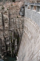
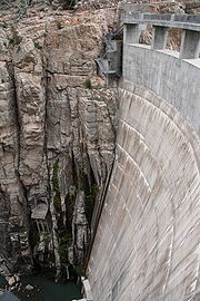 West of Cody the river is impounded in Shoshone Canyon by the Buffalo Bill Dam
, created as part of the Shoshone project
; one of the nations first water conservation projects. A number of hot springs along the Shoshone were drowned by the reservoir. From Buffalo Bill Reservoir the Shoshone splits into the North Fork, which follows a long canyon into the Absaroka Mountains to the vicinity of the east entrance of Yellowstone National Park
, and the South Fork, which originates at the southern end of the Absarokas.
Wyoming
Wyoming is a state in the mountain region of the Western United States. The western two thirds of the state is covered mostly with the mountain ranges and rangelands in the foothills of the Eastern Rocky Mountains, while the eastern third of the state is high elevation prairie known as the High...
in the United States
United States
The United States of America is a federal constitutional republic comprising fifty states and a federal district...
. Its headwaters are in the Absaroka Range
Absaroka Range
The Absaroka Range is a sub-range of the Rocky Mountains in the United States. The range stretches about 150 mi across the Montana-Wyoming border, forming the eastern boundary of Yellowstone National Park and the western side of the Bighorn Basin. The range borders the Beartooth Mountains...
in Shoshone National Forest
Shoshone National Forest
Shoshone National Forest is the first federally protected National Forest in the United States and covers nearly 2.5 million acres in the state of Wyoming. Originally a part of the Yellowstone Timberland Reserve, the forest was created by an act of Congress and signed into law by U.S....
. It ends when it runs into the Big Horn River near Lovell, Wyoming
Lovell, Wyoming
Lovell is a town in Big Horn County, Wyoming, United States. The population was 2,281 at the 2000 census.-Geography:Lovell is located at ....
. Cities it runs near or through are Cody
Cody, Wyoming
Cody is a city in Park County, Wyoming, United States. It is named after William Frederick Cody, primarily known as Buffalo Bill, from William Cody's part in the creation of the original town. The population was 9,520 at the 2010 census...
, Powell
Powell, Wyoming
Powell is a city in Park County, Wyoming, United States. The population was 5,373 at the 2000 census. Powell is an All-America City and home to Northwest College.-Geography:Powell is located at ....
, Byron
Byron, Wyoming
Byron is a town in Big Horn County, Wyoming, United States. The population was 557 at the 2000 census.-Geography:According to the United States Census Bureau, the town has a total area of 0.9 square miles , of which, 0.8 square miles of it is land and 0.1 square miles of it is...
, and Lovell
Lovell, Wyoming
Lovell is a town in Big Horn County, Wyoming, United States. The population was 2,281 at the 2000 census.-Geography:Lovell is located at ....
. Near Cody, it runs through a volcanically active region of fumaroles known as Colter's Hell
Colter's Hell
Colter's Hell is an area of fumaroles and hot springs on the Shoshone River near Cody in the US state of Wyoming. The thermal area covers about a square mile at the mouth of the Shoshone's canyon. Its thermal activity has declined ever since its description by mountain man John Colter, who passed...
. This contributed to the river being named on old maps of Wyoming as the Stinking Water River. The current name was established in 1901 due to popular demand.
Buffalo Bill Dam
Buffalo Bill Dam is a concrete arch-gravity dam on the Shoshone River in the U.S. state of Wyoming. The dam is named after the famous old West figure William "Buffalo Bill" Cody who founded the nearby town of Cody and who owned much of the land now covered by the reservoir formed by the dam, which...
, created as part of the Shoshone project
Shoshone project
The Shoshone Project is an irrigation project in the U.S. state of Wyoming. The project provides irrigation for approximately of crops in the Big Horn Basin, fulfilling the vision of local resident and developer Buffalo Bill Cody, who hoped to make the semi-arid basin into agricultural land...
; one of the nations first water conservation projects. A number of hot springs along the Shoshone were drowned by the reservoir. From Buffalo Bill Reservoir the Shoshone splits into the North Fork, which follows a long canyon into the Absaroka Mountains to the vicinity of the east entrance of Yellowstone National Park
Yellowstone National Park
Yellowstone National Park, established by the U.S. Congress and signed into law by President Ulysses S. Grant on March 1, 1872, is a national park located primarily in the U.S. state of Wyoming, although it also extends into Montana and Idaho...
, and the South Fork, which originates at the southern end of the Absarokas.
See also
- Mummy CaveMummy CaveMummy Cave is a rock shelter and archeological site in Park County, Wyoming, United States, near the eastern entrance to Yellowstone National Park. The site is adjacent to the concurrent U.S...
, an alcove carved in a cliff face by the North Fork of the Shoshone that has yielded evidence of 9000 years of occupation - ShoshoniteShoshoniteShoshonite is a basaltic rock, properly a potassic trachyandesite, composed of olivine, augite and plagioclase phenocrysts in a groundmass with calcic plagioclase and sanidine and some dark-colored volcanic glass. Shoshonite gives its name to the shoshonite series and grades into absarokite with...