
Fontana Dam
Encyclopedia
Fontana Dam is a hydroelectric dam on the Little Tennessee River
in Swain
and Graham
counties, North Carolina, USA. The dam is operated by the Tennessee Valley Authority
, which built the dam in the early 1940s to accommodate the skyrocketing electricity demands in the Tennessee Valley at the height of World War II
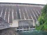
. At 480 feet (146.3 m) high, Fontana is the tallest dam in the Eastern United States, and at the time of its construction, it was the fourth tallest dam in the world. The dam impounds the 10230 acres (4,139.9 ha) Fontana Lake
, which spreads across a scenic stretch of the Little Tennessee along the southwestern boundary of the Great Smoky Mountains National Park
. The Appalachian Trail
crosses the top of the dam. Fontana is named for the now-inundated town of Fontana, a lumber and copper-mining hub once located at the mouth of Eagle Creek. The town's name was derived from the Italian word for "fountain."
to its mouth along the Tennessee River
opposite Lenoir City, Tennessee
. Fontana is located 61 miles (98.2 km) above the mouth of the Little Tennessee, in a remote area where the westward-flowing river bends briefly to the south. Fontana Dam is a 30 miles (48.3 km) drive from the two nearest cities — Maryville, Tennessee
to the west and Bryson City, North Carolina
to the east — although the small resort of Fontana Village has developed just south of the dam. The Great Smoky Mountains
rise to the north and the Yellow Creek Mountains (mostly protected by the Nantahala National Forest
) rise to the south. Fontana is the uppermost of five dams on the Little Tennessee River, with Cheoah Dam
being 10 miles (16.1 km) downstream, followed by Calderwood Dam
, Chilhowee Dam
, and Tellico Dam
.
 Along with a 29 miles (46.7 km) stretch of the Little Tennessee, Fontana Lake also extends across the lower 11 miles (17.7 km) of the Tuckasegee River (which flows southward from Cherokee
and Bryson City) and the lower 5 miles (8 km) or so of the Nantahala River
, extending into the scenic Nantahala Gorge. Several rapid-flowing mountain streams— some of which drop several thousand feet from the crest of the Great Smokies in just a few miles— empty into Fontana's north shore. The most notable of these streams — Eagle Creek and Hazel Creek — form substantial embayments just upstream from the dam.
North Carolina Highway 28 (which crosses a bridge downstream from the dam) provides the only major road access to the Fontana Dam area. At Deals Gap
, 11 miles (17.7 km) west of the dam, the road intersects U.S. Route 129
, which then continues westward to Maryville. East of the dam, NC-28 follows the lake's south shore for about 25 miles (40.2 km) before intersecting U.S. Route 74
. As part of the Fontana Project, the National Park Service
agreed to build a road along the lake's north shore, connecting the dam directly to Bryson City, although due to financial issues and environmental concerns this road was never completed, and remains one of the Fontana project's most enduring controversies.
. The dam has a flood storage capacity of 513965 acre.ft, and the combined capacity of its three generators is 293.6 megawatts. Fontana Lake has 238 miles (383 km) of shoreline and 10230 acres (4,139.9 ha) of water surface, and its surface elevation varies by 57 feet (17.4 m) annually.
 The Aluminum Company of America (ALCOA) began investigating the Little Tennessee Valley around 1910 in hopes finding a power source for the massive amounts of electricity needed at its aluminum production operations at nearby Alcoa, Tennessee
. In 1913, ALCOA purchased the Tallassee Power Company (now Tapoco
), and by 1930 the two entities had completed Cheoah and Calderwood dams, as well as Santeetlah Dam
on the Cheoah River
. By the mid-1930s, ALCOA had assessed the Fontana site and had purchased the initial 15000 acres (6,070.3 ha) for the dam's construction. In 1935, the Tennessee Valley Authority, which was concerned with the Little Tennessee's effect on flood control in the greater Tennessee Valley, began negotiating with ALCOA to assume control of the Fontana project. Although ALCOA preferred TVA build the dam, TVA was unable to get necessary funding for the project until the outbreak of World War II
in 1941, when emergency wartime initiatives called for a drastic increase in aluminum production. On August 14, 1941, TVA and ALCOA signed the "Fontana Agreement," which gave TVA possession of Fontana and control over the releases and output of Tapoco's Little Tennessee Valley dams, and in return guaranteed that ALCOA would be the primary benefactor of the dams' electrical output for at least twenty years. Congress authorized funding on December 17, 1941, and construction of Fontana Dam began on January 1, 1942.
The building of Fontana Dam and its reservoir required the purchase of 68292 acres (27,636.8 ha) of land, 5125 acres (2,074 ha) of which were forested and had to be cleared. 1,311 families, 1,047 graves, and over 60 miles (96.6 km) of roads had to be relocated. The towns of Fontana, Bushnell, Forney, and Judson
were completely inundated. The village of Welch Cove (later renamed Fontana Village) was constructed just south of the dam to house the project's workers, whose numbers had reached 5,000 by 1943 in spite of nationwide manpower shortages. Fontana Village is now a summer resort and still has some of the original buildings.
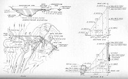
The design of the dam was unusual for TVA at the time. It was feared that the 2,818,000 yd³ (2,155,000 m³) of concrete required for the dam would create a structure so massive, that heat released during its setting would be trapped for years, and would eventually cause cracks to form. To aide the release of this heat, engineers divided the dam into contraction joints and outfitted them with grout pipes and cooling coils. The dam's spillway presented another problem, as engineers were worried that the water's 400 feet (121.9 m) drop would eventually cause erosion issues at the dam's foundation. A special spillway was thus designed that drains water out through two 34-foot (10.3 m) diameter spill pipes into a diversion tunnel equipped with a deflection system. The dam's design is largely the work of TVA Chief Architect Roland Wank
.
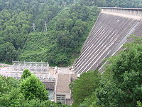
Fontana Dam was completed at a cost of $70,420,688.48 and the gates closed on November 11, 1944. Two generating units were placed in operation on January 20, 1945, in time to provide crucial energy for aluminum production in the closing months of World War II. Over 40000 acres (16,187.4 ha) along Fontana Lake's north shore were eventually transferred to the Great Smoky Mountains National Park, and several thousand acres along the south shore were transferred to the U.S. Forest Service.
, after gaining possession of Fontana's north shore tracts, reached an agreement with Swain County to replace the north shore road in the 1940s. By 1972, however, environmental concerns and funding issues had continuously stalled construction, and just 7.2 miles (11.6 km) of the road had been completed (just outside of Bryson City). In the 1970s, environmental concerns completely halted the road's progress, and locals nicknamed the unfinished 7.2 miles (11.6 km) road "The Road to Nowhere". After North Carolina's U.S. Senator Jesse Helms
secured funding for the road in 2000, the park service conducted an environmental impact study (released in 2007) and concluded that the road's construction would cause "major, adverse, long-term impacts to topography, geology, and soils" in the area. Proponents of the road argued that the environmental concerns were exaggerated. In 2007, Swain County accepted a $52 million cash settlement from the park service, and agreed to drop its demand for a new road along the North Shore.
Little Tennessee River
The Little Tennessee River is a tributary of the Tennessee River, approximately 135 miles long, in the Appalachian Mountains in the southeastern United States.-Geography:...
in Swain
Swain County, North Carolina
Swain County is a county located in the U.S. state of North Carolina. As of 2000, the population was 12,968. Its county seat is Bryson City.Swain County is home of the Nantahala River . The Nantahala is one of the most popular whitewater rafting rivers in the nation...
and Graham
Graham County, North Carolina
-Demographics:As of the census of 2000, there were 7,993 people, 3,354 households, and 2,411 families residing in the county. The population density was 27 people per square mile . There were 5,084 housing units at an average density of 17 per square mile...
counties, North Carolina, USA. The dam is operated by the Tennessee Valley Authority
Tennessee Valley Authority
The Tennessee Valley Authority is a federally owned corporation in the United States created by congressional charter in May 1933 to provide navigation, flood control, electricity generation, fertilizer manufacturing, and economic development in the Tennessee Valley, a region particularly affected...
, which built the dam in the early 1940s to accommodate the skyrocketing electricity demands in the Tennessee Valley at the height of World War II
World War II
World War II, or the Second World War , was a global conflict lasting from 1939 to 1945, involving most of the world's nations—including all of the great powers—eventually forming two opposing military alliances: the Allies and the Axis...
. At 480 feet (146.3 m) high, Fontana is the tallest dam in the Eastern United States, and at the time of its construction, it was the fourth tallest dam in the world. The dam impounds the 10230 acres (4,139.9 ha) Fontana Lake
Fontana Lake
Fontana Lake is a reservoir impounded by Fontana Dam on the Little Tennessee River located in Graham and Swain counties in North Carolina. The lake forms part of the southern border of Great Smoky Mountains National Park and the northern border of part of the Nantahala National Forest. Depending on...
, which spreads across a scenic stretch of the Little Tennessee along the southwestern boundary of the Great Smoky Mountains National Park
Great Smoky Mountains National Park
Great Smoky Mountains National Park is a United States National Park and UNESCO World Heritage Site that straddles the ridgeline of the Great Smoky Mountains, part of the Blue Ridge Mountains, which are a division of the larger Appalachian Mountain chain. The border between Tennessee and North...
. The Appalachian Trail
Appalachian Trail
The Appalachian National Scenic Trail, generally known as the Appalachian Trail or simply the AT, is a marked hiking trail in the eastern United States extending between Springer Mountain in Georgia and Mount Katahdin in Maine. It is approximately long...
crosses the top of the dam. Fontana is named for the now-inundated town of Fontana, a lumber and copper-mining hub once located at the mouth of Eagle Creek. The town's name was derived from the Italian word for "fountain."
Location
The Little Tennessee River flows for 135 miles (217.3 km) from its source in the mountains of northern GeorgiaGeorgia (U.S. state)
Georgia is a state located in the southeastern United States. It was established in 1732, the last of the original Thirteen Colonies. The state is named after King George II of Great Britain. Georgia was the fourth state to ratify the United States Constitution, on January 2, 1788...
to its mouth along the Tennessee River
Tennessee River
The Tennessee River is the largest tributary of the Ohio River. It is approximately 652 miles long and is located in the southeastern United States in the Tennessee Valley. The river was once popularly known as the Cherokee River, among other names...
opposite Lenoir City, Tennessee
Lenoir City, Tennessee
Lenoir City is a city in Loudon County, Tennessee, United States. Its population was 8,642 at the 2010 census. It is included in the Knoxville Metropolitan Area....
. Fontana is located 61 miles (98.2 km) above the mouth of the Little Tennessee, in a remote area where the westward-flowing river bends briefly to the south. Fontana Dam is a 30 miles (48.3 km) drive from the two nearest cities — Maryville, Tennessee
Maryville, Tennessee
Maryville is the county seat of Blount County, Tennessee, in the Southeastern United States. The city is located south of Knoxville. Maryville's population was 27,258 at the 2010 census. It is included in the Knoxville Metropolitan Area. Maryville has received a number of accolades for its...
to the west and Bryson City, North Carolina
Bryson City, North Carolina
Bryson City is a town in Swain County, North Carolina in the United States. The population was 1,353 as of 2009, a decrease of 4.1% since the 2000 census...
to the east — although the small resort of Fontana Village has developed just south of the dam. The Great Smoky Mountains
Great Smoky Mountains
The Great Smoky Mountains are a mountain range rising along the Tennessee–North Carolina border in the southeastern United States. They are a subrange of the Appalachian Mountains, and form part of the Blue Ridge Physiographic Province. The range is sometimes called the Smoky Mountains or the...
rise to the north and the Yellow Creek Mountains (mostly protected by the Nantahala National Forest
Nantahala National Forest
The Nantahala National Forest, established in 1920, is a national forest located in the American state of North Carolina. The word "Nantahala" is a Cherokee word meaning "Land of the Noonday Sun." The name is appropriate as, in some spots, the sun only reaches the floors of the deep gorges of the...
) rise to the south. Fontana is the uppermost of five dams on the Little Tennessee River, with Cheoah Dam
Cheoah Dam
The Cheoah Dam is a hydroelectric complex located in Graham and Swain counties, North Carolina on the Little Tennessee River between river miles 51 and 52. The Cheoah Development consists of a dam and powerhouse, the first of several constructed by the Tallassee Power Company, now Tapoco...
being 10 miles (16.1 km) downstream, followed by Calderwood Dam
Calderwood Dam
Calderwood Dam is a hydroelectric dam located along the Little Tennessee River in Blount and Monroe counties, Tennessee. Completed in 1930, the dam is owned and maintained by Tapoco, a subsidiary of the Aluminum Company of America , although the Tennessee Valley Authority controls the dam's...
, Chilhowee Dam
Chilhowee Dam
Chilhowee Dam is a hydroelectric dam located in Blount and Monroe counties, Tennessee, between river mile 33 and 34 on the Little Tennessee River. Construction began in 1955 and was completed in 1957. The dam's reservoir covers approximately at normal full pool and has a drainage area of . The...
, and Tellico Dam
Tellico Dam
Tellico Dam is a dam built by the Tennessee Valley Authority in Loudon County, Tennessee on the Little Tennessee River just above the main stem of the Tennessee River. It impounds the Tellico Reservoir....
.
Cherokee, North Carolina
Cherokee is a town in Swain County, North Carolina, USA, within the Qualla Boundary land trust. It is located in the Oconaluftee River Valley, near the intersection of U.S. Route 19 and U.S...
and Bryson City) and the lower 5 miles (8 km) or so of the Nantahala River
Nantahala River
The Nantahala River is a river in western North Carolina in the United States, within the Nantahala National Forest, and near the Great Smoky Mountains National Park. Two-lane U.S...
, extending into the scenic Nantahala Gorge. Several rapid-flowing mountain streams— some of which drop several thousand feet from the crest of the Great Smokies in just a few miles— empty into Fontana's north shore. The most notable of these streams — Eagle Creek and Hazel Creek — form substantial embayments just upstream from the dam.
North Carolina Highway 28 (which crosses a bridge downstream from the dam) provides the only major road access to the Fontana Dam area. At Deals Gap
Deals Gap, North Carolina
Deals Gap is a portion of U.S. Route 129 in Blount County, Tennessee, which also lends its name to a small unincorporated community and motorcycle resort situated in a gap in Swain County, North Carolina, United States. It is located along U.S. 129 at the Tennessee state line. The community has an...
, 11 miles (17.7 km) west of the dam, the road intersects U.S. Route 129
U.S. Route 129
U.S. Route 129 is an offshoot route of U.S. Route 29, which it intersects near Athens, Georgia. US 129 currently runs for 582 miles from Knoxville, Tennessee, to Chiefland, Florida, at U.S. Route 19 and U.S. Route 98. It passes through the states of Tennessee, North Carolina, Georgia and Florida...
, which then continues westward to Maryville. East of the dam, NC-28 follows the lake's south shore for about 25 miles (40.2 km) before intersecting U.S. Route 74
U.S. Route 74
U.S. Route 74 is an east–west United States highway that runs for from Cleveland, Tennessee to Wrightsville Beach, North Carolina.-Tennessee:Established in 1987, US-74 western terminus is exit 20 on I-75 in Cleveland...
. As part of the Fontana Project, the National Park Service
National Park Service
The National Park Service is the U.S. federal agency that manages all national parks, many national monuments, and other conservation and historical properties with various title designations...
agreed to build a road along the lake's north shore, connecting the dam directly to Bryson City, although due to financial issues and environmental concerns this road was never completed, and remains one of the Fontana project's most enduring controversies.
Capacity
Fontana Dam is 2,365 feet (721 m) long and 480 feet (146 m) high, making it the tallest dam in the Eastern United StatesUnited States
The United States of America is a federal constitutional republic comprising fifty states and a federal district...
. The dam has a flood storage capacity of 513965 acre.ft, and the combined capacity of its three generators is 293.6 megawatts. Fontana Lake has 238 miles (383 km) of shoreline and 10230 acres (4,139.9 ha) of water surface, and its surface elevation varies by 57 feet (17.4 m) annually.
Background and construction
Alcoa, Tennessee
Alcoa is a city in Blount County, Tennessee, United States, south of Knoxville. Its population was 7,744 at the 2000 census. It is part of the Knoxville, Tennessee Metropolitan Statistical Area....
. In 1913, ALCOA purchased the Tallassee Power Company (now Tapoco
Tapoco
Tapoco, originally Tallassee Power Company, is a generator and supplier of electric power. Tapoco is a division of APGI which in turn is owned by ALCOA Inc. The Tapoco Project serves to generate and supply hydroelectric power to ALCOA’s Tennessee Operations, an aluminum smelting and rolling mill...
), and by 1930 the two entities had completed Cheoah and Calderwood dams, as well as Santeetlah Dam
Santeetlah Dam
Santeetlah Dam is a hydroelectric development on the Cheoah River in Graham County, North Carolina. The dam together with a pipeline/tunnel facility, and a powerhouse form the Santeetlah Development...
on the Cheoah River
Cheoah River
The Cheoah River is a tributary of the Little Tennessee River in North Carolina in the United States.It is located in Graham County in far western North Carolina, near Robbinsville, and is approximately 20 miles in length...
. By the mid-1930s, ALCOA had assessed the Fontana site and had purchased the initial 15000 acres (6,070.3 ha) for the dam's construction. In 1935, the Tennessee Valley Authority, which was concerned with the Little Tennessee's effect on flood control in the greater Tennessee Valley, began negotiating with ALCOA to assume control of the Fontana project. Although ALCOA preferred TVA build the dam, TVA was unable to get necessary funding for the project until the outbreak of World War II
World War II
World War II, or the Second World War , was a global conflict lasting from 1939 to 1945, involving most of the world's nations—including all of the great powers—eventually forming two opposing military alliances: the Allies and the Axis...
in 1941, when emergency wartime initiatives called for a drastic increase in aluminum production. On August 14, 1941, TVA and ALCOA signed the "Fontana Agreement," which gave TVA possession of Fontana and control over the releases and output of Tapoco's Little Tennessee Valley dams, and in return guaranteed that ALCOA would be the primary benefactor of the dams' electrical output for at least twenty years. Congress authorized funding on December 17, 1941, and construction of Fontana Dam began on January 1, 1942.
The building of Fontana Dam and its reservoir required the purchase of 68292 acres (27,636.8 ha) of land, 5125 acres (2,074 ha) of which were forested and had to be cleared. 1,311 families, 1,047 graves, and over 60 miles (96.6 km) of roads had to be relocated. The towns of Fontana, Bushnell, Forney, and Judson
Judson, Swain County, North Carolina
Judson was a small town in Swain County, North Carolina. It was submerged when the Fontana Dam was built, creating the Fontana Lake reservoir. Some structures can be visited when the lake is at its yearly low....
were completely inundated. The village of Welch Cove (later renamed Fontana Village) was constructed just south of the dam to house the project's workers, whose numbers had reached 5,000 by 1943 in spite of nationwide manpower shortages. Fontana Village is now a summer resort and still has some of the original buildings.
The design of the dam was unusual for TVA at the time. It was feared that the 2,818,000 yd³ (2,155,000 m³) of concrete required for the dam would create a structure so massive, that heat released during its setting would be trapped for years, and would eventually cause cracks to form. To aide the release of this heat, engineers divided the dam into contraction joints and outfitted them with grout pipes and cooling coils. The dam's spillway presented another problem, as engineers were worried that the water's 400 feet (121.9 m) drop would eventually cause erosion issues at the dam's foundation. A special spillway was thus designed that drains water out through two 34-foot (10.3 m) diameter spill pipes into a diversion tunnel equipped with a deflection system. The dam's design is largely the work of TVA Chief Architect Roland Wank
Roland Wank
Roland A. Wank was a Hungarian modernist architect, best known for his work for the Tennessee Valley Authority in the United States.Wank was educated at the Royal Joseph Technical University in Budapest...
.
Fontana Dam was completed at a cost of $70,420,688.48 and the gates closed on November 11, 1944. Two generating units were placed in operation on January 20, 1945, in time to provide crucial energy for aluminum production in the closing months of World War II. Over 40000 acres (16,187.4 ha) along Fontana Lake's north shore were eventually transferred to the Great Smoky Mountains National Park, and several thousand acres along the south shore were transferred to the U.S. Forest Service.
North Shore Road controversy
The construction of Fontana Dam led to the flooding of most of North Carolina Highway 288, which connected Deals Gap and Bryson City. The National Park ServiceNational Park Service
The National Park Service is the U.S. federal agency that manages all national parks, many national monuments, and other conservation and historical properties with various title designations...
, after gaining possession of Fontana's north shore tracts, reached an agreement with Swain County to replace the north shore road in the 1940s. By 1972, however, environmental concerns and funding issues had continuously stalled construction, and just 7.2 miles (11.6 km) of the road had been completed (just outside of Bryson City). In the 1970s, environmental concerns completely halted the road's progress, and locals nicknamed the unfinished 7.2 miles (11.6 km) road "The Road to Nowhere". After North Carolina's U.S. Senator Jesse Helms
Jesse Helms
Jesse Alexander Helms, Jr. was a five-term Republican United States Senator from North Carolina who served as chairman of the Senate Foreign Relations Committee from 1995 to 2001...
secured funding for the road in 2000, the park service conducted an environmental impact study (released in 2007) and concluded that the road's construction would cause "major, adverse, long-term impacts to topography, geology, and soils" in the area. Proponents of the road argued that the environmental concerns were exaggerated. In 2007, Swain County accepted a $52 million cash settlement from the park service, and agreed to drop its demand for a new road along the North Shore.
External links
- Fontana Reservoir — official TVA site
- TVA historical information
- Fontana Dam Images
- Maps of the quadrangle