
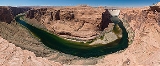
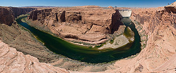
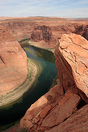
Glen Canyon
Encyclopedia
Canyon
A canyon or gorge is a deep ravine between cliffs often carved from the landscape by a river. Rivers have a natural tendency to reach a baseline elevation, which is the same elevation as the body of water it will eventually drain into. This forms a canyon. Most canyons were formed by a process of...
that is located in southeastern and south central Utah
Utah
Utah is a state in the Western United States. It was the 45th state to join the Union, on January 4, 1896. Approximately 80% of Utah's 2,763,885 people live along the Wasatch Front, centering on Salt Lake City. This leaves vast expanses of the state nearly uninhabited, making the population the...
and northwestern Arizona
Arizona
Arizona ; is a state located in the southwestern region of the United States. It is also part of the western United States and the mountain west. The capital and largest city is Phoenix...
within the Vermilion Cliffs
Vermilion Cliffs
The Vermilion Cliffs are the second "step" up in the five-step Grand Staircase of the Colorado Plateau. Reddish or vermilion-colored cliffs are found along U.S. Highway 89 and U.S. Highway 89A near Kanab, Utah . They extend from a location near Page, Arizona, west for a considerable distance, in...
area. It was carved by the Colorado River
Colorado River
The Colorado River , is a river in the Southwestern United States and northwestern Mexico, approximately long, draining a part of the arid regions on the western slope of the Rocky Mountains. The watershed of the Colorado River covers in parts of seven U.S. states and two Mexican states...
.
A reservoir, Lake Powell
Lake Powell
Lake Powell is a huge reservoir on the Colorado River, straddling the border between Utah and Arizona . It is the second largest man-made reservoir in the United States behind Lake Mead, storing of water when full...
, was created by the Glen Canyon Dam
Glen Canyon Dam
Glen Canyon Dam is a concrete arch dam on the Colorado River in northern Arizona in the United States, just north of Page. The dam was built to provide hydroelectricity and flow regulation from the upper Colorado River Basin to the lower. Its reservoir is called Lake Powell, and is the second...
. Lake Powell
Lake Powell
Lake Powell is a huge reservoir on the Colorado River, straddling the border between Utah and Arizona . It is the second largest man-made reservoir in the United States behind Lake Mead, storing of water when full...
emerged from a struggle over damming Dinosaur National Monument
Dinosaur National Monument
Dinosaur National Monument is a National Monument located on the southeast flank of the Uinta Mountains on the border between Colorado and Utah at the confluence of the Green and Yampa Rivers. Although most of the monument area is in Moffat County, Colorado, the Dinosaur Quarry is located in Utah...
. The Sierra Club
Sierra Club
The Sierra Club is the oldest, largest, and most influential grassroots environmental organization in the United States. It was founded on May 28, 1892, in San Francisco, California, by the conservationist and preservationist John Muir, who became its first president...
and its leader, David Brower, were instrumental in blocking the dam in Dinosaur. In exchange, they accepted a dam in Glen Canyon. Before the canyon was flooded, but after the struggle in Congress, Brower floated the canyon and realized what a tremendous resource it was. This experience transformed Brower's attitude towards environmental preservation, making him more radical and less likely to compromise. It was very similar to the experience of John Muir
John Muir
John Muir was a Scottish-born American naturalist, author, and early advocate of preservation of wilderness in the United States. His letters, essays, and books telling of his adventures in nature, especially in the Sierra Nevada mountains of California, have been read by millions...
with the Hetch Hetchy Reservoir
Hetch Hetchy Reservoir
Hetch Hetchy Reservoir is a reservoir in Yosemite National Park, about northeast from the city of Merced, California. The reservoir has a capacity of and is formed by the concrete gravity O'Shaughnessy Dam in Hetch Hetchy Valley on the Tuolumne River...
. For Brower, it steeled him for the battle over a dam in the Grand Canyon
Grand Canyon
The Grand Canyon is a steep-sided canyon carved by the Colorado River in the United States in the state of Arizona. It is largely contained within the Grand Canyon National Park, the 15th national park in the United States...
. Beginning in the late 1990s, the Sierra Club and other organizations renewed the call to drain Lake Powell in Lower Glen Canyon.
Pre-dam history and rescue archaeology
University of Utah
The University of Utah, also known as the U or the U of U, is a public, coeducational research university in Salt Lake City, Utah, United States. The university was established in 1850 as the University of Deseret by the General Assembly of the provisional State of Deseret, making it Utah's oldest...
and the Museum of Northern Arizona
Museum of Northern Arizona
The Museum of Northern Arizona is a museum in Flagstaff, Arizona, USA, that was established as a repository for Native American artifacts and natural history specimens from the Colorado Plateau.The museum was founded in 1928 by zoologist Dr. Harold S...
, using National Park research grants, planned an emergency excavation of Lower Glen Canyon, which was soon to be flooded by the new Glen Canyon Dam. Between 1958 and 1960, four investigative phases, combined with other surveys prior to 1957, discovered 250 sites. Beginning in 1958, the Lower Glen Canyon survey was finished.
Excavations
Excavations began during the summer of 1958 on 16 sites. A thesis emerged that prehistoric people living permanently on the highlands south of Glen Canyon, and on the Cummings Mesa, farmed the Lower Glen Canyon on a seasonal basis, and gathered raw materials. To prove this thesis of seasonal habitation, criteria such as architectural units, locations of trail systems, occurrence of ceremonial structures, prevalence of burials, and position of natural and cultural strata. Four types of sites are described in the survey classified as either open sites situated on rock terraces; talus sites on broken material below cliffs; shelter sites in protected areas under overhanging cliffs; and cliff sites beneath ledges or in caves and canyon walls. Open sites are the majority on both sides of the river. The majority of sites, mostly Navajo camps, feature lithic garbage or ceramics, or both. TalusScree
Scree, also called talus, is a term given to an accumulation of broken rock fragments at the base of crags, mountain cliffs, or valley shoulders. Landforms associated with these materials are sometimes called scree slopes or talus piles...
sites are rarely recorded.
Most of the cultural remains found are chipped stone tools (lithic materials), including projectile points, scrapers, drills, knives, choppers, and ground stone tools and manos (grinders). The collection of sherds are mostly Tusayan Gray Ware and Tusayan White Ware. Petroglyph
Petroglyph
Petroglyphs are pictogram and logogram images created by removing part of a rock surface by incising, picking, carving, and abrading. Outside North America, scholars often use terms such as "carving", "engraving", or other descriptions of the technique to refer to such images...
panels are found throughout Glen Canyon. “Pecked and incised figures depict mountain sheep, human figures, birds, human handprints and animal tracks. Geometric figures range from circles and spirals to highly complex rectilinear patterns. The human figures have triangular bodies. Painted figures have been reported for both sides of the river.... Petroglyph panels of such quality are lacking from the highland regions adjacent to Glen Canyon” (Long 61).
Prehistoric cultural periods
Studies indicate a chronology for the Lower Glen Canyon prehistory, “from pre-A.D. 1 to the 15th century and recorded history from 1776 to the present” (Long 61).- A Late Basketmaker II EraLate Basketmaker II EraThe Late Basketmaker II Era was a cultural period of Ancient Pueblo People when people began living in pit-houses, raised maize and squash, and were proficient basket makers and weavers...
(generally AD 50-500) is represented by several sites. Radiocarbon dates from charcoal material are from A.D. 250 to 440 (plus or minus 80 years). Basketmaker IIIBasketmaker III EraThe Basketmaker III Era, AD 500 to 750, also called the "Modified Basketmaker" period, was the third period in which Ancient Pueblo People were cultivating food, began making pottery and living in more sophisticated clusters of pit-house dwellings...
is not found in the Lower Glen Canyon, but is documented in Navajo Canyon, a large left bank tributary of the Colorado River, within the geographical area of the Lower Glen Canyon (Long 62). Basketmaker III introduces fired pottery, mostly Lino Black-on-gray and Lino Gray, and some small amounts of Lino Fugitive Red and Obelisk Gray. The Basketmaker cultureBasketmaker (culture)The Basketmaker culture of the Ancient Pueblo People began about 1500 BC and continued until about AD 500 with the beginning of the Pueblo I Era...
is believed to have lasted later than Pueblo I.
- Pueblo I EraPueblo I EraThe Pueblo I Era, from AD 750 to 900, was the first period in which Ancient Pueblo People began living in pueblo structures and realized an evolution in architecture, artistic expression, and water conservation...
(AD 750-900) remains are found at Rock Creek in Lower Glen Canyon, and in Navajo Canyon. The pottery types are Kana-a Black-on-white, Deadmans Black-on-red, and Kana-a Gray, made from deposits found in Lizard Alcove. Pueblo I is the best documented period of Navajo Canyon, beginning in 800 A.D, lasting 200 years. “Pueblo IIPueblo II EraThe Pueblo II Era, AD 900 to 1150, was the second pueblo period of the Ancient Pueblo People of the Four Corners region of the American southwest. During this period people lived in dwellings made of stone and mortar, enjoyed communal activities in kivas, built towers and water conversing dams,...
in Navajo Canyon is represented by the absence of Kana-a Black-on-white and the dominance of Black Mesa Black-on-white” (Long 62).
- Pueblo IIPueblo II EraThe Pueblo II Era, AD 900 to 1150, was the second pueblo period of the Ancient Pueblo People of the Four Corners region of the American southwest. During this period people lived in dwellings made of stone and mortar, enjoyed communal activities in kivas, built towers and water conversing dams,...
(AD 900-1100) and early Pueblo IIIPueblo III EraThe Pueblo III Era, AD 1150 to 1350, was the third period, also called the "Great Pueblo period" when Ancient Pueblo People lived in large cliff-dwelling, multi-storied pueblo, or cliff-side talus house communities...
is the best documented cultural area in Lower Glen Canyon corresponding with habitation on Cummings Mesa. Pottery includes mostly Tusayan varieties, Black-on-white, Black-on-red, and Red Wear Polychromes.
- HopiHopiThe Hopi are a federally recognized tribe of indigenous Native American people, who primarily live on the Hopi Reservation in northeastern Arizona. The Hopi area according to the 2000 census has a population of 6,946 people. Their Hopi language is one of the 30 of the Uto-Aztecan language...
people from the Jeddito area came into the canyons in the 14th century, represented by Yellow Wares, mostly Jeddito Black-on-yellow, and Jeddito plain.
Most of the ceramic material found in the main canyon was probably made in the highlands, although it is possible some pottery was manufactured in Lower Glen Canyon. Clay deposits are found along the river, and some crude pottery specimens, that may have been made there. Only four burials were found in Lower Glen Canyon at three sites. Trash dumps are not very common at most sites. This is more evidence to suggest the seasonal occupation of hunters and farmers.
Historic periods
Recorded history begins with the Dominguez-Escalante expedition in 1776.Cultural similarities are based on the presence, or absence, of certain types of ceramic wares. (Long 63). Group types of pottery include Kayenta (Tusayan and Tsegi Orange Ware), Virgin (San Juan Red and White Wares), with Fremont, and Mesa Verde or Anasazi types of White and Desert Gray Ware found mostly on the right bank of Colorado. Basketmaker II is characterized by a lack of pottery, and above ground and underground cists lined with slabs.

Kiva
A kiva is a room used by modern Puebloans for religious rituals, many of them associated with the kachina belief system. Among the modern Hopi and most other Pueblo peoples, kivas are square-walled and underground, and are used for spiritual ceremonies....
, a ceremonial structure, made mostly of masonry, featuring jacal walls of sticks and reeds set in mortar in a single row of masonry. The presence of metates are evidence that campsites with slab-lined hearths being inhabited for longer periods. Agricultural structures are not found in the main lower canyon, and no formalized fields are found in the main canyon because of alleviation and slope wash burying (Long, 66). Houses, when found, were mostly sandstone slab with mortar, having one to seven rooms. “Well constructed mealing bins which usually denote permanency were lacking in the Lower Glen Canyon. In contrast, on Cummings Mesa at Surprise Pueblo, there was one entire room devoted to mealing bins…” (Long 65). In the highlands, granaries were near or incorporated into permanent Pueblos, compared with smaller ones near temporary sites in the Canyon (Long 66). “Home Base” pueblos in the nearby highlands on Cummings Mesa and Paiute Mesa are believed to support the temporary farming and the hunting parties who used an extensive trail system in the main canyon, still in use today.
Natural resources for tool-making
“Stone tool manufacturing appears to have been an important industry for the entire Glen Canyon region, perhaps one of the major reasons for occupation” (Long 66). Cryptocrystalline rocks fill the PleistocenePleistocene
The Pleistocene is the epoch from 2,588,000 to 11,700 years BP that spans the world's recent period of repeated glaciations. The name pleistocene is derived from the Greek and ....
gravel beds on the Carmel platforms. Scattered lithic tools and materials indicate workshops of various sizes. There is a lack of siliceous material in the highlands, but tools are found there made from the gravel beds in the river.
There are very few ground stone artifacts, such as manos, metates, and scrapers, found in the main canyon, since these tools are mainly found in the highlands. In the main canyon, a large number of chipped implements, ranging from small arrowheads to large knives, are found. Finished tools, and possibly blanks taken to the mesa, were probably used for trade.
External links
- glencanyon.org information from the Glen Canyon Institute
- Glen Canyon Natural History Association
Further reading
- Crampton, C. Gregory. Ghosts of Glen Canyon: History Beneath Lake Powell, revised edition (2009). ISBN 978-0-87480-946-6
- Eliot Porter (Photographer), Daniel P Beard (Preface), David Brower (Foreword) (Eds., 1997). The Place No One Knew - Glen Canyon on the Colorado Publisher: Gibbs Smith, Publisher; Cmv edition (July 21, 2000). ISBN-13: 978-0879059712.
- Fowler, Don D. The Glen Canyon Country, (2011). ISBN 978-1-60781-134-3